Beinn an Duibhe

Hill, Mountain in Sutherland

Scotland

Beinn an Duibhe

The summit of Beinn an Duibhe Looking east across the Faraid peninsula to the distant Whiten Head.
The summit of Beinn an Duibhe Credit: Michael Earnshaw

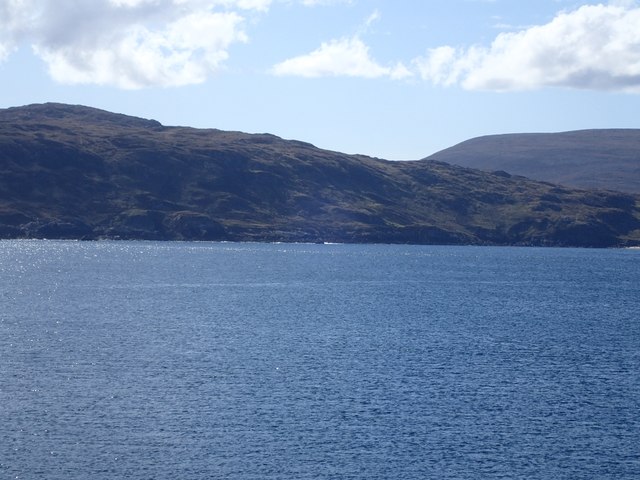
Beinn an Duibhe, located in Sutherland, Scotland, is a prominent hill/mountain rising to a height of 528 meters (1,732 feet). It forms part of the vast and rugged landscape of the Scottish Highlands, renowned for its natural beauty and stunning vistas.

Beinn an Duibhe is characterized by its distinctive shape, featuring a steep and rocky terrain that provides a challenging climb for outdoor enthusiasts. Its summit offers breathtaking panoramic views of the surrounding countryside, including the nearby Dornoch Firth and the rolling hills of Sutherland. On a clear day, it is even possible to see as far as the Moray Firth and the mountains of Wester Ross.

The hill/mountain is predominantly composed of Torridonian sandstone, a type of sedimentary rock that is characteristic of the region. This geology contributes to its rugged appearance and the presence of exposed rock formations along its slopes.

Hikers and mountaineers are drawn to Beinn an Duibhe for its rewarding ascent and the opportunity to immerse themselves in the unspoiled wilderness. The surrounding area is rich in flora and fauna, with heather, grasses, and mosses covering the lower slopes, and an array of bird species, including peregrine falcons and golden eagles, soaring overhead.

Beinn an Duibhe is a popular destination for outdoor activities, such as hillwalking, scrambling, and wildlife spotting. Its accessibility and proximity to other natural attractions make it an ideal location for those seeking an adventure in the Scottish Highlands.

If you have any feedback on the listing, please let us know in the comments section below.

Beinn an Duibhe Images

Images are sourced within 2km of 58.586948/-4.8405879 or Grid Reference NC3470. Thanks to Geograph Open Source API. All images are credited.

The summit of Beinn an Duibhe Looking east across the Faraid peninsula to the distant Whiten Head.
The summit of Beinn an Duibhe
Looking east across the Faraid peninsula to the distant Whiten Head.
North east slopes of Beinn an Duibhe Taken from the west side of Faraid Head
North east slopes of Beinn an Duibhe
Taken from the west side of Faraid Head
Sea and coast line to south east of Port Obhar Taken from the west side of Faraid Head
Sea and coast line to south east of Port Obhar
Taken from the west side of Faraid Head
UXB,  Unexploded NATO shell Unexploded NATO (blue) shell in an impact crater on the MOD NATO Naval firing range. The shell was fired from 12 miles offshore. Some of the soil inside & around the impact crater has been carbonised by the heat of the first exploding shell.
UXB, Unexploded NATO shell
Unexploded NATO (blue) shell in an impact crater on the MOD NATO Naval firing range. The shell was fired from 12 miles offshore. Some of the soil inside & around the impact crater has been carbonised by the heat of the first exploding shell.
Disused cargo container Disused cargo container strafed with built and shrapnel holes. Latitude 58°35'56.01"N longitude 4°51'47.26"W
Disused cargo container
Disused cargo container strafed with built and shrapnel holes. Latitude 58°35'56.01"N longitude 4°51'47.26"W
Sou'westerly view from the slopes of Sgribhis bheinn That's Loch Inshore and Fashven which rises to 460 metres that you see in the distance.
Sou'westerly view from the slopes of Sgribhis bheinn
That's Loch Inshore and Fashven which rises to 460 metres that you see in the distance.
Walker following the contour on the eastern slopes of Sgribhis bheinn Fashven is dominant in the centre picture and is 460 metres AMSL.
Walker following the contour on the eastern slopes of Sgribhis bheinn
Fashven is dominant in the centre picture and is 460 metres AMSL.
Port Odhar, Cape Wrath Bombing Range
Land Rover, Cape Wrath Range
Sunset from the bomb site. Cape Wrath Range.
Sunset from the bomb site.
Cape Wrath Range.
Old Milestone on Cape Wrath peninsula, Durness parish Stone post by the UC road, in parish of Durness (Highland District), Cape Wrath peninsula.

Inscription reads:-
8 {Within the drawing of a puffin}
(8 miles to Cape Wrath)

Surveyed, but GR estimated based on old maps.

Milestone Society National ID: HI_CWKD08
Old Milestone on Cape Wrath peninsula, Durness parish
Stone post by the UC road, in parish of Durness (Highland District), Cape Wrath peninsula. Inscription reads:- 8 {Within the drawing of a puffin} (8 miles to Cape Wrath) Surveyed, but GR estimated based on old maps. Milestone Society National ID: HI_CWKD08
Old Milestone by Daill, Durness Parish Milestone by the UC road, in parish of Durness (Highland District), Cape Wrath peninsula, on downhill to bridge, North side of road.

Inscription reads:-
9
(To Cape Wrath)

Surveyed

Milestone Society National ID: HI_CWKD09
Old Milestone by Daill, Durness Parish
Milestone by the UC road, in parish of Durness (Highland District), Cape Wrath peninsula, on downhill to bridge, North side of road. Inscription reads:- 9 (To Cape Wrath) Surveyed Milestone Society National ID: HI_CWKD09
Cape Wrath: the minibus plods on The journey to Cape Wrath, the northwest tip of mainland Britain, is not a straightforward one. It involves firstly the ferry across the Kyle of Durness, and then an 11-mile minibus ride on a dirt track across desolate military ranges.

Here, with admittedly approximate grid reference details, we have climbed from Achiemore and look through the minibus windscreen toward the continuing track.
Cape Wrath: the minibus plods on
The journey to Cape Wrath, the northwest tip of mainland Britain, is not a straightforward one. It involves firstly the ferry across the Kyle of Durness, and then an 11-mile minibus ride on a dirt track across desolate military ranges. Here, with admittedly approximate grid reference details, we have climbed from Achiemore and look through the minibus windscreen toward the continuing track.
Cape Wrath: passing Lochan nam Breac Buidhe The journey to Cape Wrath, the northwest tip of mainland Britain, is not a straightforward one. It involves firstly the ferry across the Kyle of Durness, and then an 11-mile minibus ride on a dirt track across desolate military ranges.

We are about a third of the way there now, and pass this small body of water on the south side of the track.
Cape Wrath: passing Lochan nam Breac Buidhe
The journey to Cape Wrath, the northwest tip of mainland Britain, is not a straightforward one. It involves firstly the ferry across the Kyle of Durness, and then an 11-mile minibus ride on a dirt track across desolate military ranges. We are about a third of the way there now, and pass this small body of water on the south side of the track.
Bombing range - BEWARE!! That's Loch Inshore and Inshore House which you see in the background.
Bombing range - BEWARE!!
That's Loch Inshore and Inshore House which you see in the background.
Ignorance is Bliss!! Bomb threat or no bomb threat, it's time to cool off.
Ignorance is Bliss!!
Bomb threat or no bomb threat, it's time to cool off.
Lochan Nam Breac Budhe Just look at the evidence of mass Red Deer visits to this lochan by noting the disturbed sand in the foreground. A human footprint on these shores is a rarity.
Lochan Nam Breac Budhe
Just look at the evidence of mass Red Deer visits to this lochan by noting the disturbed sand in the foreground. A human footprint on these shores is a rarity.
Larger beasts have been on these shores last night! Note the turmoil on the foreshore caused by the Red Deer on their nocturnal visit.
Larger beasts have been on these shores last night!
Note the turmoil on the foreshore caused by the Red Deer on their nocturnal visit.
Show me another place!

Beinn an Duibhe is located at Grid Ref: NC3470 (Lat: 58.586948, Lng: -4.8405879)

Unitary Authority: Highland

Police Authority: Highlands and Islands

What 3 Words

///howler.sooner.scorecard. Near Oldshoremore, Highland

Nearby Locations

Beinn an Duibhe

Related Wikis

Achiemore, Durness

Achiemore was a crofting community located on the Cape Wrath peninsula near the village of Durness in the Scottish county of Sutherland. The hamlet is...

Faraid Head

Faraid Head (Scottish Gaelic: An Fharaird) is a small peninsula on the northern coast of Sutherland, Highland, Scotland, located around 2 miles (3 kilometres...

Balnakeil

Balnakeil is a hamlet in the parish of Durness, Sutherland, Scottish Highlands, and is in the Scottish council area of Highland. It is on the north coast...

Kyle of Durness

Kyle of Durness is a coastal inlet on the north coast of Scotland in the county of Sutherland. It extends 5+1⁄2 miles (9 kilometres) inland from Balnakeil...

Nearby Amenities

Located within 500m of 58.586948,-4.8405879
Beinn an Duibhe
Ele: 221
Ele Ft: 726
Natural: peak
Source: OS7
Lat/Long: 58.5867292/-4.8417259
The data included in this document is from www.openstreetmap.org. The data is made available under ODbL.

Have you been to Beinn an Duibhe?

Leave your review of Beinn an Duibhe below (or comments, questions and feedback).