Sròn Liath

Hill, Mountain in Ross-shire

Scotland

Sròn Liath

Northern slope of Sron Liath The gentle slope north from Sron Liath descending to a broad col from which a broad ridge climbs to Am Faochagach, the central and most distant dome in the image.
Up to date OS mapping suggests something of a track following the ridge line; it wasn't there in 1993.
Northern slope of Sron Liath Credit: Trevor Littlewood

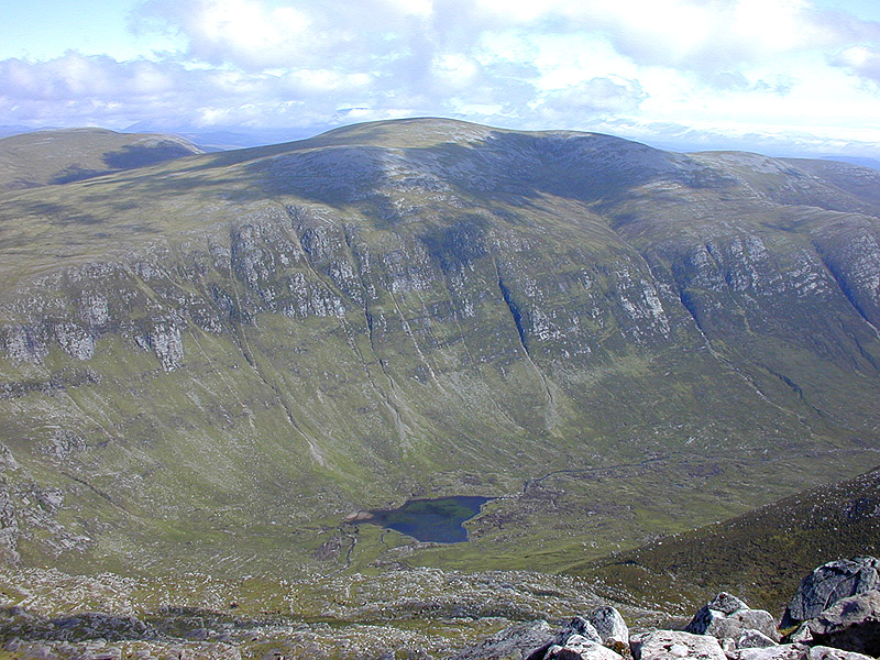
Sròn Liath is a prominent hill located in the county of Ross-shire, Scotland. It stands at an elevation of approximately 773 meters (2,536 feet) above sea level. The hill is part of the Torridon group, which is renowned for its rugged and stunning landscapes.

Situated in the Northwest Highlands, Sròn Liath offers breathtaking panoramic views of the surrounding area. Its distinctive shape, with its steep slopes and a rocky summit, adds to its allure. The hill is composed mainly of Torridonian sandstone, which gives it a reddish hue and adds to its geological significance.

Access to Sròn Liath is relatively straightforward, with several routes available for hikers and mountaineers. One of the most popular trails starts from the nearby village of Torridon, offering a challenging yet rewarding ascent. The path is well-marked and takes visitors through a variety of landscapes, from woodland and moorland to exposed rocky sections.

Upon reaching the summit, hikers are rewarded with breathtaking views of Loch Torridon, the surrounding Munros, and the Torridon Hills. On clear days, it is even possible to see the Isle of Skye in the distance. The hill is also home to a diverse range of flora and fauna, including heather, mosses, and various bird species.

Overall, Sròn Liath is a must-visit destination for outdoor enthusiasts seeking to explore the natural beauty and geological wonders of the Scottish Highlands.

If you have any feedback on the listing, please let us know in the comments section below.

Sròn Liath Images

Images are sourced within 2km of 57.744384/-4.8487606 or Grid Reference NH3076. Thanks to Geograph Open Source API. All images are credited.

Northern slope of Sron Liath The gentle slope north from Sron Liath descending to a broad col from which a broad ridge climbs to Am Faochagach, the central and most distant dome in the image.
Up to date OS mapping suggests something of a track following the ridge line; it wasn't there in 1993.
Northern slope of Sron Liath
The gentle slope north from Sron Liath descending to a broad col from which a broad ridge climbs to Am Faochagach, the central and most distant dome in the image. Up to date OS mapping suggests something of a track following the ridge line; it wasn't there in 1993.
Path up Am Faochagach
Track on Drochaid a’ Ghlas Tuill
Towards Am Faochagach
Allt an t-Seasgaich On slopes SW of Tom Ban Mor.
Allt an t-Seasgaich
On slopes SW of Tom Ban Mor.
Rocky moorland SE of Carn Dubh Looking across the west end of Loch Glascarnoch towards the Fannichs.
Rocky moorland SE of Carn Dubh
Looking across the west end of Loch Glascarnoch towards the Fannichs.
Moorland west of Tom Ban Mor Looking over the west end of Loch Glascarnoch towards the Fannichs.
Moorland west of Tom Ban Mor
Looking over the west end of Loch Glascarnoch towards the Fannichs.
Allt Airigh Cheiridh On moorland west of Tom Ban Mor.
Allt Airigh Cheiridh
On moorland west of Tom Ban Mor.
Moorland above Loch Glascarnoch Looking south east along the loch.
Moorland above Loch Glascarnoch
Looking south east along the loch.
Memorial cairn near summit of Tom Ban Mor above Loch Glascarnoch This small cairn stands on the southern flank of Tom Ban Mor and was built in memory of an accidental shooting. There is no description on the cairn.
Memorial cairn near summit of Tom Ban Mor above Loch Glascarnoch
This small cairn stands on the southern flank of Tom Ban Mor and was built in memory of an accidental shooting. There is no description on the cairn.
Cairn on summit of Sron Liath with view towards Creag Rainich, Strathvaich Forest
Allt na h-Uidhe A path keeps to the west side of the burn before heading off to the beallach.
Allt na h-Uidhe
A path keeps to the west side of the burn before heading off to the beallach.
Allt na h-Uidhe There are a few waterfalls on this burn.
Allt na h-Uidhe
There are a few waterfalls on this burn.
Allt na h-Uidhe The path to Am Faochagach follows the burn for the start of the ascent to the ridge.
Allt na h-Uidhe
The path to Am Faochagach follows the burn for the start of the ascent to the ridge.
Descending the Am Faochagach path towards Loch a Gharbhrain The Fannich Forest occupies the horizon.
Descending the Am Faochagach path towards Loch a Gharbhrain
The Fannich Forest occupies the horizon.
Tom Bàn Mòr Part of a ridge descending southwards from Am Faochagach in the Strathvaich Forest - looking across Loch Glascarnoch.
Tom Bàn Mòr
Part of a ridge descending southwards from Am Faochagach in the Strathvaich Forest - looking across Loch Glascarnoch.
On the flank of Meall Gorm Looking over the valley of the Allt Glas Toll Mor towards the beallach where  the normal path from Dirrie Mor first hits the ridge that leads to the Munro summit of Am Faochagach. The Fannichs lie beyond the beallach.
On the flank of Meall Gorm
Looking over the valley of the Allt Glas Toll Mor towards the beallach where the normal path from Dirrie Mor first hits the ridge that leads to the Munro summit of Am Faochagach. The Fannichs lie beyond the beallach.
Cairn on the Am Faochagach ridge From here the footpath leaves the tracked ridge to descend to the Dirrie Mor. In the background is Beinn Dhearg.
Cairn on the Am Faochagach ridge
From here the footpath leaves the tracked ridge to descend to the Dirrie Mor. In the background is Beinn Dhearg.
Show me another place!

Sròn Liath is located at Grid Ref: NH3076 (Lat: 57.744384, Lng: -4.8487606)

Unitary Authority: Highland

Police Authority: Highlands and Islands

What 3 Words

///width.brimmed.reserve. Near Achnasheen, Highland

Nearby Locations

Sròn Liath

Related Wikis

Am Faochagach

Am Faochagach (953 m) is a mountain in the Northwest Highlands of Scotland. It is located in Wester Ross, north of the main road to Ullapool. A rounded...

Loch Glascarnoch

Loch Glascarnoch is a 7-kilometre-long (4.3 mi) reservoir in the highlands of Scotland between Ullapool and Inverness. It is dammed on its eastern end...

Northern Scotland

Northern Scotland was an administrative division of Scotland used for police and fire services. It consisted of Highland, the Orkney Islands, the Shetland...

A835 road

The A835 is a road in the Scottish Highlands linking Inverness to Ullapool and the Far North of Scotland. == Route == The A835 starts at Tore on the Black...

Have you been to Sròn Liath?

Leave your review of Sròn Liath below (or comments, questions and feedback).