Barmore Hill

Hill, Mountain in Wigtownshire

Scotland

Barmore Hill

Road to Blairderry
Road to Blairderry Credit: David Baird

Barmore Hill is a prominent geographical feature located in Wigtownshire, Scotland. It is situated near the town of Stranraer and is part of the Southern Uplands range. The hill stands at an elevation of approximately 127 meters (417 feet) above sea level and offers stunning panoramic views of the surrounding countryside.

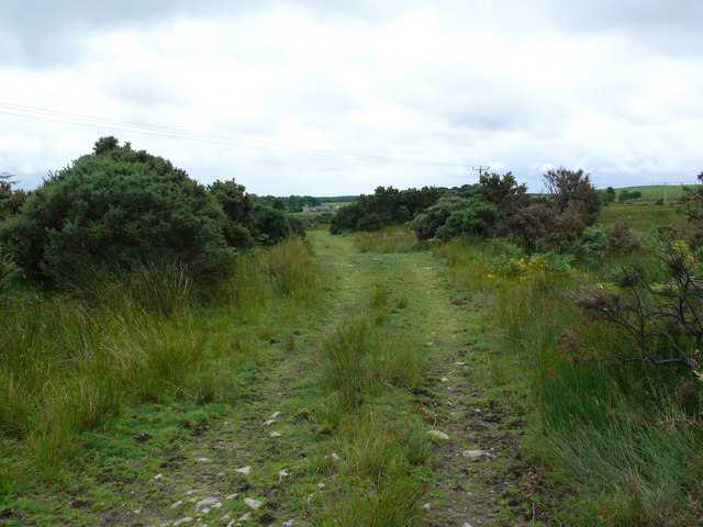
Barmore Hill is known for its distinctive shape and rugged terrain, with its slopes covered in heather, grass, and scattered rocks. It is a popular destination for hikers and outdoor enthusiasts, attracting visitors from both local and international areas.

The hill is easily accessible by foot, with several well-maintained trails leading to its summit. These trails vary in difficulty, catering to individuals of different fitness levels. For experienced hikers, Barmore Hill provides a challenging climb, while its gentle slopes and clear pathways make it suitable for casual walkers as well.

At the top of Barmore Hill, one can enjoy breathtaking views of the surrounding landscape, including the picturesque Loch Ryan and the Irish Sea. On clear days, it is possible to see as far as the Isle of Man and the Mull of Kintyre.

Aside from its natural beauty, Barmore Hill also holds historical significance. It is believed to have been a site of ancient settlements, with remnants of stone structures and burial mounds found in the vicinity.

Overall, Barmore Hill offers a unique and rewarding outdoor experience, combining natural beauty, historical interest, and stunning vistas that make it a must-visit destination for nature lovers and avid hikers alike.

If you have any feedback on the listing, please let us know in the comments section below.

Barmore Hill Images

Images are sourced within 2km of 54.911471/-4.6798787 or Grid Reference NX2860. Thanks to Geograph Open Source API. All images are credited.

Road to Blairderry
Road to Blairderry
Blairderry Farm from the slopes of Barwhil Looking to Blairderry (Blar doire - the field of the oak wood) over an area of clearfell from Barwhil (Barr chuill - hill of the hazels)
Blairderry Farm from the slopes of Barwhil
Looking to Blairderry (Blar doire - the field of the oak wood) over an area of clearfell from Barwhil (Barr chuill - hill of the hazels)
Farmland near Muil Farm The ridge is called Near Barbunny - barr buin duibh - the hill of the black bottom, or bog.
Farmland near Muil Farm
The ridge is called Near Barbunny - barr buin duibh - the hill of the black bottom, or bog.
The old military road near Kiltersan Built in the 18th century, it runs to the port at Portpatrick. It was constructed so that troops could be moved quickly to Ireland in times of trouble.
The old military road near Kiltersan
Built in the 18th century, it runs to the port at Portpatrick. It was constructed so that troops could be moved quickly to Ireland in times of trouble.
Kiltersan Kiltersan - Cill tarsuinn - means the chapel at the crossing, although the crossing of what isn't obvious.
Kiltersan
Kiltersan - Cill tarsuinn - means the chapel at the crossing, although the crossing of what isn't obvious.
Barlae Bridge The bridge carries the A75 over the Water of Tarf. Barlae comes from the gaelic barr laegh - the calves' hill.
Barlae Bridge
The bridge carries the A75 over the Water of Tarf. Barlae comes from the gaelic barr laegh - the calves' hill.
Water of Tarf from Barlae Bridge Looking south.
Water of Tarf from Barlae Bridge
Looking south.
Water of Tarf from Barlae Bridge Looking north
Water of Tarf from Barlae Bridge
Looking north
Muil farm and the A75 The work taking place behind the farm is in connection with a new water mains being run across the breadth of the county.
Muil farm and the A75
The work taking place behind the farm is in connection with a new water mains being run across the breadth of the county.
Field gate, moor and forestry near Muil farm
Kiltersan Farm from the Gargrie Taken at dusk. Kiltersan farm is in the middle distance. The hill on the horizon is the Knock of Luce.
Kiltersan Farm from the Gargrie
Taken at dusk. Kiltersan farm is in the middle distance. The hill on the horizon is the Knock of Luce.
Barskeoch Moss The moss has been recently burnt to encourage the spring growth. Drumlins rise from the surrounding moorland like green islands - the nearest one has the wonderful name of Blairnagobber, the field of the goats.
Barskeoch Moss
The moss has been recently burnt to encourage the spring growth. Drumlins rise from the surrounding moorland like green islands - the nearest one has the wonderful name of Blairnagobber, the field of the goats.
Stones of Kiltersan Looking due east along the Old Military Road.
Stones of Kiltersan
Looking due east along the Old Military Road.
Winter at Kiltersan
Winter at Kiltersan
Kiltersan Farm Looking towards Kiltersan Farm and reservoir from the Old Military Road
Kiltersan Farm
Looking towards Kiltersan Farm and reservoir from the Old Military Road
Knockbreck View from this hill, which is one of the highest in this grid, towards Barmore Farm.
Knockbreck
View from this hill, which is one of the highest in this grid, towards Barmore Farm.
Military Road This track forms part of the old military road and looks towards Kiltersan.
Military Road
This track forms part of the old military road and looks towards Kiltersan.
Knockbreck View north from this hill which is mainly open grasslands for sheep farming.
Knockbreck
View north from this hill which is mainly open grasslands for sheep farming.
Show me another place!

Barmore Hill is located at Grid Ref: NX2860 (Lat: 54.911471, Lng: -4.6798787)

Unitary Authority: Dumfries and Galloway

Police Authority: Dumfries and Galloway

What 3 Words

///across.investors.redouble. Near Newton Stewart, Dumfries & Galloway

Related Wikis

Barhapple Loch

Barhapple Loch is a small semicircular freshwater loch located in Wigtownshire, Dumfries and Galloway in Scotland. Barhapple Loch is principally known...

Kirkcowan railway station

Kirkcowan railway station served the village of Kirkcowan, Dumfries and Galloway, Scotland from 1861 to 1965 on the Portpatrick and Wigtownshire Joint...

Kirkcowan

Kirkcowan is an area about 15 miles in length, and from nearly two to nearly seven miles in breadth, comprising 30,580 acres, of which 7000 are arable...

Tarf Water, Wigtownshire

The Tarf Water is a river in the former county of Wigtownshire in south-west Scotland. It rises on the Ayrshire border (55.0048°N 4.7815°W / 55.0048;...

Nearby Amenities

Located within 500m of 54.911471,-4.6798787
Power: tower
Lat/Long: 54.9125456/-4.6861169
Power: tower
Lat/Long: 54.9152178/-4.6767068
Power: tower
Lat/Long: 54.913493/-4.682781
Power: pole
Lat/Long: 54.9148069/-4.6749696
Power: pole
Lat/Long: 54.9144493/-4.6762759
Power: pole
Lat/Long: 54.9141116/-4.6774346
Power: pole
Lat/Long: 54.9137/-4.6788266
Power: pole
Lat/Long: 54.9133793/-4.6800095
Power: pole
Lat/Long: 54.9130324/-4.6812487
Power: pole
Lat/Long: 54.9126639/-4.6825683
Power: pole
Lat/Long: 54.9123077/-4.6838477
Power: pole
Lat/Long: 54.9119577/-4.6850735
Power: pole
Lat/Long: 54.9115862/-4.6863636
Power: pole
Lat/Long: 54.91123/-4.6876779
Power: pole
Lat/Long: 54.9102089/-4.6843543
Power: pole
Lat/Long: 54.9107966/-4.6839876
Power: pole
Lat/Long: 54.911352/-4.6836423
Power: pole
Lat/Long: 54.9119878/-4.6832465
Power: pole
Lat/Long: 54.9131086/-4.6825402
Power: pole
Lat/Long: 54.9134142/-4.6823462
Power: pole
Lat/Long: 54.914129/-4.6819077
Power: pole
Lat/Long: 54.9105289/-4.6831281
Power: pole
Lat/Long: 54.9108557/-4.6818942
Power: pole
Lat/Long: 54.911129/-4.6808581
Power: pole
Lat/Long: 54.9114011/-4.6797968
Power: pole
Lat/Long: 54.9117937/-4.6782854
Power: pole
Lat/Long: 54.9122052/-4.67671
Power: pole
Lat/Long: 54.9126012/-4.6752122
Power: pole
Lat/Long: 54.9129982/-4.6736814
Power: pole
Lat/Long: 54.9114475/-4.6726605
Power: pole
Lat/Long: 54.9119927/-4.6730139
Power: pole
Lat/Long: 54.9125072/-4.6733649
Power: pole
Lat/Long: 54.9098159/-4.6858902
The data included in this document is from www.openstreetmap.org. The data is made available under ODbL.

Have you been to Barmore Hill?

Leave your review of Barmore Hill below (or comments, questions and feedback).