Crawhin Hill

Hill, Mountain in Renfrewshire

Scotland

Crawhin Hill

Near Rottenburn Bridge Near Rottenburn Bridge, on the Scenic Road between Greenock and Largs.
Near Rottenburn Bridge Credit: L J Cunningham

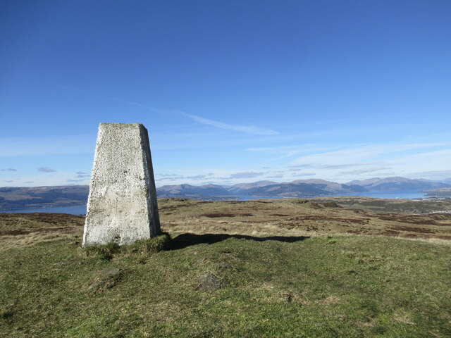
Crawhin Hill is a prominent hill located in the county of Renfrewshire, Scotland. Sitting at an elevation of 291 meters (955 feet), it is often considered a notable landmark in the area. The hill is situated in the southern part of Renfrewshire, near the village of Lochwinnoch.

Crawhin Hill is characterized by its gently sloping grassy terrain, making it a relatively easy climb for outdoor enthusiasts. The summit offers stunning panoramic views of the surrounding countryside, including the nearby Clyde Muirshiel Regional Park and the rolling hills of Renfrewshire. On clear days, the view stretches as far as the Isle of Arran and the Ailsa Craig in the Firth of Clyde.

The hill is a popular destination for walkers and hikers due to its accessibility and the picturesque scenery it offers. There are several well-marked trails leading to the summit, with the most common route starting from the village of Lochwinnoch. Along the way, visitors can expect to encounter a diverse range of flora and fauna, adding to the charm of the hill.

Crawhin Hill also holds historical significance, as it is believed to have been used as a hillfort during ancient times. Archaeological excavations have uncovered remnants of Iron Age settlements on the hill, including stone structures and pottery fragments.

Overall, Crawhin Hill is a beautiful natural landmark, offering visitors the opportunity to enjoy a leisurely hike and immerse themselves in the rich history and breathtaking scenery of Renfrewshire.

If you have any feedback on the listing, please let us know in the comments section below.

Crawhin Hill Images

Images are sourced within 2km of 55.903333/-4.8115619 or Grid Reference NS2471. Thanks to Geograph Open Source API. All images are credited.

Near Rottenburn Bridge Near Rottenburn Bridge, on the Scenic Road between Greenock and Largs.
Near Rottenburn Bridge
Near Rottenburn Bridge, on the Scenic Road between Greenock and Largs.
Old Largs Road Passing the trees at Garvock Hill.
Old Largs Road
Passing the trees at Garvock Hill.
North Rottenburn Just north of Rottenburn Bridge on the Old Largs Road from Greenock
North Rottenburn
Just north of Rottenburn Bridge on the Old Largs Road from Greenock
Firebreak Looking through forestry to Ferret of Keith.
Firebreak
Looking through forestry to Ferret of Keith.
Old Largs Road Nearing the top of the rise between Garvock Hill and Berry Hill to the south of Loch Thom.
Old Largs Road
Nearing the top of the rise between Garvock Hill and Berry Hill to the south of Loch Thom.
Unnamed glen off Old Largs Road North Rottenburn flows through this glen to the south of Loch Thom.
Unnamed glen off Old Largs Road
North Rottenburn flows through this glen to the south of Loch Thom.
Dunrod Well - Shielhill Glen Dunrod Well
Dunrod Well - Shielhill Glen
Dunrod Well
Shielhill and Dunrod Hill A hill farm above the Firth of Clyde near Inverkip.
Shielhill and Dunrod Hill
A hill farm above the Firth of Clyde near Inverkip.
Wind turbine below Dunrod Hill A single turbine just east of Shielhill.
Wind turbine below Dunrod Hill
A single turbine just east of Shielhill.
The summit of Hillside Hill A view from the rather tautologically named Hillside Hill, with Loch Thom visible below.
The summit of Hillside Hill
A view from the rather tautologically named Hillside Hill, with Loch Thom visible below.
Trig pillar on Dunrod Hill A trig with a view across the Firth of Clyde to the hills of the Cowal Peninsula.
Trig pillar on Dunrod Hill
A trig with a view across the Firth of Clyde to the hills of the Cowal Peninsula.
Between Dunrod Hill and Cauldron Hill A small moorland hill with rock outcrops on the moorland plateau above the Firth of Clyde.
Between Dunrod Hill and Cauldron Hill
A small moorland hill with rock outcrops on the moorland plateau above the Firth of Clyde.
Water-waster in sluice house, Greenock Cut A control mechanism for removing excess water from the Greenock Cut aqueduct.  For a fuller description, see <a href="https://www.geograph.org.uk/photo/1234617">NS2372 : Water-waster mechanism</a>.
Water-waster in sluice house, Greenock Cut
A control mechanism for removing excess water from the Greenock Cut aqueduct. For a fuller description, see NS2372 : Water-waster mechanism.
Dunrod Trigpoint in Renfrewshire A view of the trig point at the summit of Dunrod Hill in Renfrewshire, Scotland. Dunrod Hill (298m) can be climbed from Greenock Cut Visitor Centre and Daff Reservoir can be seen in the background.
Dunrod Trigpoint in Renfrewshire
A view of the trig point at the summit of Dunrod Hill in Renfrewshire, Scotland. Dunrod Hill (298m) can be climbed from Greenock Cut Visitor Centre and Daff Reservoir can be seen in the background.
Finger post sign in Leapmoor Forest Near the former Scottish Water treatment works building.
Finger post sign in Leapmoor Forest
Near the former Scottish Water treatment works building.
Shielhill Farm Donkeys at Shielhill Farm
Shielhill Farm
Donkeys at Shielhill Farm
Daff Reservoir from the Kelly Cut Path
Rotten Craigs Rotten Craigs
Rotten Craigs
Rotten Craigs
Show me another place!

Crawhin Hill is located at Grid Ref: NS2471 (Lat: 55.903333, Lng: -4.8115619)

Unitary Authority: Inverclyde

Police Authority: Renfrewshire and Inverclyde

What 3 Words

///unwraps.pens.solved. Near Inverkip, Inverclyde

Nearby Locations

Crawhin Hill

Related Wikis

Loch Thom

Loch Thom is a reservoir which since 1827 has provided a water supply to the town of Greenock in Inverclyde, Scotland. It is named after the civil engineer...

IBM railway station

IBM railway station (formerly known as IBM Halt) is a currently disused railway station on the Inverclyde Line, 25+1⁄2 miles (41 km) west of Glasgow Central...

Spango Valley

Spango Valley is a steep sided valley to the south-west of Greenock, Scotland. It runs approximately south west to north east for around 2.4 km (1.5 mi...

Ravenscraig railway station

Ravenscraig railway station was a railway station located south west of the town of Greenock, Inverclyde, Scotland, originally as part of the Greenock...

Nearby Amenities

Located within 500m of 55.903333,-4.8115619
Crawhin Hill
Ele: 235
Natural: peak
Lat/Long: 55.9033548/-4.8117902
Bench
Backrest: yes
Lat/Long: 55.9053617/-4.8155512
Bench
Backrest: yes
Lat/Long: 55.9068881/-4.8115884
Bench
Backrest: yes
Lat/Long: 55.9068656/-4.8116689
Bench
Backrest: yes
Lat/Long: 55.9068403/-4.811739
Bench
Backrest: yes
Lat/Long: 55.9056424/-4.8151054
The data included in this document is from www.openstreetmap.org. The data is made available under ODbL.

Have you been to Crawhin Hill?

Leave your review of Crawhin Hill below (or comments, questions and feedback).