Cairnwhin Hill

Hill, Mountain in Ayrshire

Scotland

Cairnwhin Hill

Thome Hill trig pillar, S8053 A very bleak and boggy location. The pillar was completed on 15th July 1954 costing £19.11s.6d.
Thome Hill trig pillar, S8053 Credit: Graeme Paterson

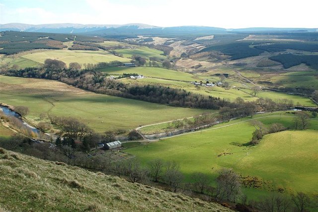
Cairnwhin Hill is a prominent hill located in Ayrshire, a historic county in southwest Scotland. Standing at an elevation of around 311 meters (1,020 feet), it offers breathtaking panoramic views of the surrounding countryside, making it a popular destination for hikers and nature enthusiasts.

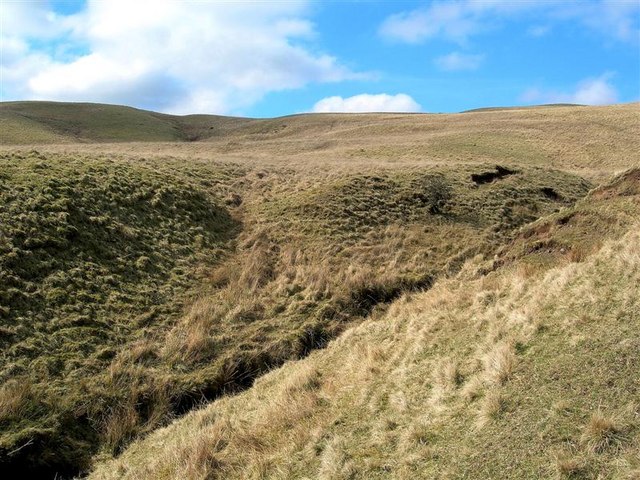
This hill is characterized by its distinctive conical shape and is situated within an area of rolling hills, lush green fields, and scattered woodlands. The terrain is predominantly composed of grassy slopes, with some rocky outcrops adding to its rugged appeal.

Cairnwhin Hill boasts a rich history, with evidence of prehistoric settlements and ancient burial sites found in the vicinity. The name "Cairnwhin" is derived from the Gaelic language, meaning "hill of the gorse," reflecting the presence of the yellow-flowered shrub that adorns its slopes during certain seasons.

For those interested in outdoor activities, Cairnwhin Hill offers various walking and hiking trails that suit different levels of fitness. The summit can be reached via a well-maintained path, providing a rewarding challenge for climbers. Along the way, visitors can enjoy the diverse flora and fauna, including heather, wildflowers, and various bird species that inhabit the area.

Overall, Cairnwhin Hill is a picturesque and historically significant landmark in Ayrshire, attracting visitors with its natural beauty, recreational opportunities, and cultural heritage. Whether it's exploring its ancient roots or simply admiring the stunning views, this hill offers an unforgettable experience for all who venture to its summit.

If you have any feedback on the listing, please let us know in the comments section below.

Cairnwhin Hill Images

Images are sourced within 2km of 55.181082/-4.7648294 or Grid Reference NX2490. Thanks to Geograph Open Source API. All images are credited.

Thome Hill trig pillar, S8053 A very bleak and boggy location. The pillar was completed on 15th July 1954 costing £19.11s.6d.
Thome Hill trig pillar, S8053
A very bleak and boggy location. The pillar was completed on 15th July 1954 costing £19.11s.6d.
Thome Hill monument Just NNE of trig, as shown on 1:25,000 map. No inscription other than a date, which appears to be 1960.
Thome Hill monument
Just NNE of trig, as shown on 1:25,000 map. No inscription other than a date, which appears to be 1960.
Tree-lined road in the Stinchar valley On the B734, Pinmore to Barr road, in effect little more than a country lane.
Tree-lined road in the Stinchar valley
On the B734, Pinmore to Barr road, in effect little more than a country lane.
Driveway to Minuntion in the Stinchar valley
Building work in the Stinchar valley Seen from the B734 Pinmore to Barr road.
Building work in the Stinchar valley
Seen from the B734 Pinmore to Barr road.
Corrugated iron barn at Merkland in the Stinchar valley Plenty of rosehips ready for picking!
Corrugated iron barn at Merkland in the Stinchar valley
Plenty of rosehips ready for picking!
River Stinchar at Kirkland
Balligmorrie in the Stinchar valley
Barn at Cairnwhin In the Stinchar valley.
Barn at Cairnwhin
In the Stinchar valley.
Kirkland In the Stinchar valley.
Kirkland
In the Stinchar valley.
Forest track in Lambdoughty Forest
Towards Traboyack
Towards Traboyack
Pool On Daldowie Hill Viewed from one of the shooting butts on a fine April morning.
Pool On Daldowie Hill
Viewed from one of the shooting butts on a fine April morning.
Burn Above Benan Farm This small burn flows down from the rough grazing on Benan Hill, later entering a narrow valley before reaching the River Stinchar.
Burn Above Benan Farm
This small burn flows down from the rough grazing on Benan Hill, later entering a narrow valley before reaching the River Stinchar.
Pool On Daldowie Hill A man-made pool, high above the Stinchar Valley.
Pool On Daldowie Hill
A man-made pool, high above the Stinchar Valley.
Hillside Tracks Sheep tracks on the grassy hillside above the Stinchar Valley.  Viewed in early April, before the new season's growth had started.
Hillside Tracks
Sheep tracks on the grassy hillside above the Stinchar Valley. Viewed in early April, before the new season's growth had started.
Hill Burn A small burn flowing down the side of Benan Hill, eventually reaching the River Stinchar.
Hill Burn
A small burn flowing down the side of Benan Hill, eventually reaching the River Stinchar.
Stinchar Valley View Looking down to the Stinchar Valley from the edge of Cantersty Hill.  Kirkland Farm is shown at the bend of the river at the foot of the slope.
Stinchar Valley View
Looking down to the Stinchar Valley from the edge of Cantersty Hill. Kirkland Farm is shown at the bend of the river at the foot of the slope.
Show me another place!

Cairnwhin Hill is located at Grid Ref: NX2490 (Lat: 55.181082, Lng: -4.7648294)

Unitary Authority: South Ayrshire

Police Authority: Ayrshire

What 3 Words

///startles.stumpy.youths. Near Girvan, South Ayrshire

Nearby Locations

Cairnwhin Hill

Related Wikis

Pinmore railway station

Pinmore railway station served the hamlet of Pinmore, South Ayrshire, Scotland from 1877 to 1965 on the Girvan and Portpatrick Junction Railway. ��2�...

Barr, Ayrshire

Barr is a village in the South West of Ayrshire, Scotland, approximately 8 miles (13 km) from the town of Girvan. There are various opinions as to the...

Pinwherry

Pinwherry is a hamlet in the civil parish of Colmonell, in the council area of South Ayrshire, Scotland. It is 8 miles south of Girvan. In 1961 it had...

Pinwherry railway station

Pinwherry railway station served the village of Pinwherry, South Ayrshire, Scotland from 1887 to 1965 on the Girvan and Portpatrick Junction Railway....

Nearby Amenities

Located within 500m of 55.181082,-4.7648294
Power: pole
Lat/Long: 55.185289/-4.7664646
The data included in this document is from www.openstreetmap.org. The data is made available under ODbL.

Have you been to Cairnwhin Hill?

Leave your review of Cairnwhin Hill below (or comments, questions and feedback).