Craigbickerae Hill

Hill, Mountain in Ayrshire

Scotland

Craigbickerae Hill

Driveway to Minuntion in the Stinchar valley
Driveway to Minuntion in the Stinchar valley Credit: Oliver Dixon

The requested URL returned error: 429 Too Many Requests

If you have any feedback on the listing, please let us know in the comments section below.

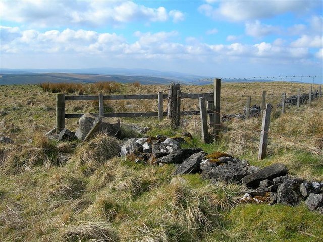
Craigbickerae Hill Images

Images are sourced within 2km of 55.192549/-4.7717369 or Grid Reference NX2392. Thanks to Geograph Open Source API. All images are credited.

Driveway to Minuntion in the Stinchar valley
Building work in the Stinchar valley Seen from the B734 Pinmore to Barr road.
Building work in the Stinchar valley
Seen from the B734 Pinmore to Barr road.
Corrugated iron barn at Merkland in the Stinchar valley Plenty of rosehips ready for picking!
Corrugated iron barn at Merkland in the Stinchar valley
Plenty of rosehips ready for picking!
River Stinchar at Kirkland
Barn at Cairnwhin In the Stinchar valley.
Barn at Cairnwhin
In the Stinchar valley.
Kirkland In the Stinchar valley.
Kirkland
In the Stinchar valley.
View From Benan Hill Looking down the rough grazing towards Tormitchell Quarry, in the next square.  The turbines in the distance belong to Hadyard Hill Wind Farm.
View From Benan Hill
Looking down the rough grazing towards Tormitchell Quarry, in the next square. The turbines in the distance belong to Hadyard Hill Wind Farm.
Pool On Daldowie Hill Viewed from one of the shooting butts on a fine April morning.
Pool On Daldowie Hill
Viewed from one of the shooting butts on a fine April morning.
Burn Above Benan Farm This small burn flows down from the rough grazing on Benan Hill, later entering a narrow valley before reaching the River Stinchar.
Burn Above Benan Farm
This small burn flows down from the rough grazing on Benan Hill, later entering a narrow valley before reaching the River Stinchar.
On The Edge Of Kirkdominae Hill Looking across rough and improved grazing land towards the Stinchar Valley.  The Hill is named after the ancient Kirkdominae Church, which was notorious for a somewhat lively annual fair.  (Source:  "Discovering Ayrshire" by John Strawhorn & Ken Andrew)
On The Edge Of Kirkdominae Hill
Looking across rough and improved grazing land towards the Stinchar Valley. The Hill is named after the ancient Kirkdominae Church, which was notorious for a somewhat lively annual fair. (Source: "Discovering Ayrshire" by John Strawhorn & Ken Andrew)
Not This Way! Most hill sheep move away when a walker approaches them, usually stopping soon for a look back.  These 5 stood there and watched me as I skirted Kirkdominae Hill and let me take the shot quite easily.  I expect that they would have moved if I had walked towards them.
Not This Way!
Most hill sheep move away when a walker approaches them, usually stopping soon for a look back. These 5 stood there and watched me as I skirted Kirkdominae Hill and let me take the shot quite easily. I expect that they would have moved if I had walked towards them.
Kirkdominae Hill View Improved grazing land in the Stinchar Valley.  The wind turbine in the distance is part of Hadyard Hill Wind Farm.
Kirkdominae Hill View
Improved grazing land in the Stinchar Valley. The wind turbine in the distance is part of Hadyard Hill Wind Farm.
Fences On Kirkland Hill This 3-way junction of fences, close to the top of the hill, is shown on the Explorer map.
Fences On Kirkland Hill
This 3-way junction of fences, close to the top of the hill, is shown on the Explorer map.
Kirkland Hill View Looking towards Hadyard Hill Wind Farm from the top of Kirkland Hill.  Viewed at the start of April.  Even at this stage of the season, the tussocky grass made slow walking conditions.
Kirkland Hill View
Looking towards Hadyard Hill Wind Farm from the top of Kirkland Hill. Viewed at the start of April. Even at this stage of the season, the tussocky grass made slow walking conditions.
On Kirkland Hill Last year's growth of tussocky grass on the top of Kirkland Hill.  Viewed at the beginning of April.
On Kirkland Hill
Last year's growth of tussocky grass on the top of Kirkland Hill. Viewed at the beginning of April.
Dyke & Fence On Kirkland Hill Commonly found in lower hill country, the old dry-stane dyke has fallen into disrepair and has been supplemented by a fence.
Dyke & Fence On Kirkland Hill
Commonly found in lower hill country, the old dry-stane dyke has fallen into disrepair and has been supplemented by a fence.
Rough Grazing On Benan Hill Walking conditions on this hill were quite tricky.  Apart from the tussocky nature of the vegetation, there were lots of small, wet holes - good ankle-twisting stuff!
Rough Grazing On Benan Hill
Walking conditions on this hill were quite tricky. Apart from the tussocky nature of the vegetation, there were lots of small, wet holes - good ankle-twisting stuff!
Dyke & Fence On Benan Hill An old dry-stane dyke and a modern fence near the top of Benan Hill.  Walking conditions on the land on the right, which had been grazed by cattle, were considerably easier than those on the rest of this hill.  Daldowie Hill, in another square, is shown in the distance on the left.
Dyke & Fence On Benan Hill
An old dry-stane dyke and a modern fence near the top of Benan Hill. Walking conditions on the land on the right, which had been grazed by cattle, were considerably easier than those on the rest of this hill. Daldowie Hill, in another square, is shown in the distance on the left.
Show me another place!

Craigbickerae Hill is located at Grid Ref: NX2392 (Lat: 55.192549, Lng: -4.7717369)

Unitary Authority: South Ayrshire

Police Authority: Ayrshire

What 3 Words

///irritable.boast.croaking. Near Girvan, South Ayrshire

Related Wikis

Pinmore railway station

Pinmore railway station served the hamlet of Pinmore, South Ayrshire, Scotland from 1877 to 1965 on the Girvan and Portpatrick Junction Railway. ��2�...

Barr, Ayrshire

Barr is a village in the South West of Ayrshire, Scotland, approximately 8 miles (13 km) from the town of Girvan. There are various opinions as to the...
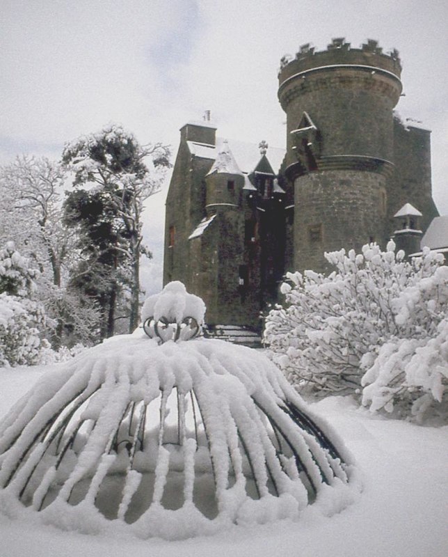
Penkill Castle

Penkill Castle is a 16th-century castle with later additions. It is around 1⁄2 mile (800 metres) south of Old Dailly, northeast of Girvan in south Ayrshire...

Pinwherry railway station

Pinwherry railway station served the village of Pinwherry, South Ayrshire, Scotland from 1887 to 1965 on the Girvan and Portpatrick Junction Railway....

Nearby Amenities

Located within 500m of 55.192549,-4.7717369
Power: pole
Lat/Long: 55.1883876/-4.7716844
Power: pole
Lat/Long: 55.1888013/-4.7706693
Power: pole
Lat/Long: 55.1892784/-4.7694204
Power: pole
Lat/Long: 55.1896787/-4.7684076
Power: pole
Lat/Long: 55.1900601/-4.7674656
Power: pole
Lat/Long: 55.1904644/-4.7664127
Power: pole
Lat/Long: 55.1908862/-4.7653362
Power: pole
Lat/Long: 55.1884428/-4.7688066
Power: pole
Lat/Long: 55.1905102/-4.7652252
The data included in this document is from www.openstreetmap.org. The data is made available under ODbL.

Have you been to Craigbickerae Hill?

Leave your review of Craigbickerae Hill below (or comments, questions and feedback).