Gallow Hill

Hill, Mountain in Wigtownshire

Scotland

Gallow Hill

New Square at Glenluce On the corner of Church Street and Main Street.
New Square at Glenluce Credit: Billy McCrorie

Gallow Hill is a prominent hill located in the region of Wigtownshire, Scotland. Situated near the town of Wigtown, it is a notable geographical feature that has significant historical and natural value.

Rising to a height of approximately 300 meters (984 feet), Gallow Hill offers stunning panoramic views of the surrounding landscape. Its position near the coast allows visitors to enjoy breathtaking vistas of the nearby Solway Firth and the Irish Sea. The hill is covered in lush green vegetation, with scattered trees and shrubs dotting its slopes.

Gallow Hill holds a significant place in history as it is believed to have been a site of execution during the times of the Scottish witch trials. The name "Gallow Hill" derives from the gallows that were once erected on its summit. It is said that accused witches were brought to this hill to face their punishment, adding a somber and eerie aspect to its historic significance.

Today, Gallow Hill serves as a popular destination for hikers and nature enthusiasts. Several well-marked trails lead visitors to the summit, where they can enjoy the breathtaking views and immerse themselves in the tranquility of the surrounding countryside. The hill's rich biodiversity also makes it a haven for birdwatchers and wildlife enthusiasts, with various species of birds and small mammals inhabiting its slopes.

Overall, Gallow Hill in Wigtownshire offers a unique blend of natural beauty and historical significance, making it a must-visit destination for those seeking both scenic views and a glimpse into Scotland's past.

If you have any feedback on the listing, please let us know in the comments section below.

Gallow Hill Images

Images are sourced within 2km of 54.885115/-4.7911511 or Grid Reference NX2158. Thanks to Geograph Open Source API. All images are credited.

New Square at Glenluce On the corner of Church Street and Main Street.
New Square at Glenluce
On the corner of Church Street and Main Street.
Church Street, Glenluce Viewed from Main Street.
Church Street, Glenluce
Viewed from Main Street.
Main Street, Glenluce Viewed from the junction with Bankfield Road.
Main Street, Glenluce
Viewed from the junction with Bankfield Road.
Main Street, Glenluce From the junction with Bankfield Road.
Main Street, Glenluce
From the junction with Bankfield Road.
Bankfield Road, Glenluce Viewed from the Main Street.
Bankfield Road, Glenluce
Viewed from the Main Street.
New Square, Glenluce The bottom tier viewed from Main Street.
New Square, Glenluce
The bottom tier viewed from Main Street.
Shelter at the New Square Glenluce Located on the corner of Church Street and the Main Street.
Shelter at the New Square Glenluce
Located on the corner of Church Street and the Main Street.
New Square, Glenluce Up at the second tier.
New Square, Glenluce
Up at the second tier.
New Square, Glenluce Up at the top tier.
New Square, Glenluce
Up at the top tier.
New Square, Glenluce At the top tier looking down towards the Main Street.
New Square, Glenluce
At the top tier looking down towards the Main Street.
Shelter at the New Square, Glenluce Looking down from the top tier towards Main Street.
Shelter at the New Square, Glenluce
Looking down from the top tier towards Main Street.
New Square, Glenluce Steps up to the top tier.
New Square, Glenluce
Steps up to the top tier.
Bridge over Lady Burn, Glenluce On Bankfield Road.
Bridge over Lady Burn, Glenluce
On Bankfield Road.
Bankfield Road, Glenluce Leading to Main Street.
Bankfield Road, Glenluce
Leading to Main Street.
Lady Burn, Glenluce Viewed from the road bridge on Bankfield Road.
Lady Burn, Glenluce
Viewed from the road bridge on Bankfield Road.
Lady Burn, Glenluce Viewed from the road bridge on Bankfield Road.
Lady Burn, Glenluce
Viewed from the road bridge on Bankfield Road.
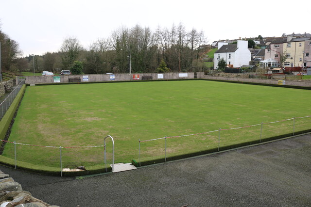
Bowling Green, Glenluce Viewed from School Road.
Bowling Green, Glenluce
Viewed from School Road.
Glenluce Bowling Club Viewed from School Road.
Glenluce Bowling Club
Viewed from School Road.
Show me another place!

Gallow Hill is located at Grid Ref: NX2158 (Lat: 54.885115, Lng: -4.7911511)

Unitary Authority: Dumfries and Galloway

Police Authority: Dumfries and Galloway

What 3 Words

///spoons.factoring.influence. Near Stranraer, Dumfries & Galloway

Nearby Locations

Gallow Hill

Related Wikis

Glenluce railway station

Glenluce station was a station open in 1862 on the former Port Road that was constructed on the Portpatrick and Wigtownshire Joint Railway. It served the...

Old Luce

Old Luce is a civil parish in Dumfries and Galloway, Scotland. It lies in the Machars peninsula, in the traditional county of Wigtownshire. The parish...

Glenluce

Glenluce (Scottish Gaelic: Clachan Ghlinn Lus) is a small village in the parish of Old Luce in Wigtownshire, Scotland.It contains a village shop,a caravan...

Castle of Park

The Castle of Park is a 16th-century L-plan tower house near Glenluce, in the historic county of Wigtownshire in Dumfries and Galloway, Scotland. It...

Nearby Amenities

Located within 500m of 54.885115,-4.7911511
Power: tower
Lat/Long: 54.8890763/-4.7901032
Power: tower
Lat/Long: 54.8870258/-4.7954727
Power: pole
Lat/Long: 54.8890713/-4.7930069
Power: pole
Lat/Long: 54.8892572/-4.7920977
Power: pole
Lat/Long: 54.8894362/-4.7912219
Power: pole
Lat/Long: 54.8895156/-4.7897159
Power: pole
Lat/Long: 54.8886779/-4.7918858
Power: pole
Lat/Long: 54.8882784/-4.7929023
Power: pole
Lat/Long: 54.8878981/-4.793935
Power: pole
Lat/Long: 54.8874892/-4.7949824
Power: pole
Lat/Long: 54.8871375/-4.7959332
Power: pole
Lat/Long: 54.8867464/-4.7969605
Power: pole
Lat/Long: 54.8862743/-4.7982091
Power: pole
Lat/Long: 54.8888576/-4.7900793
Power: pole
Lat/Long: 54.8883917/-4.791348
Power: pole
Lat/Long: 54.8879382/-4.7924718
Power: pole
Lat/Long: 54.8874738/-4.7937191
Power: pole
Lat/Long: 54.8870202/-4.7949046
Power: pole
Lat/Long: 54.8866191/-4.7959265
Power: pole
Lat/Long: 54.8860915/-4.7973159
Power: pole
Lat/Long: 54.8855931/-4.7986221
Power: pole
Lat/Long: 54.8809064/-4.7927523
Power: pole
Lat/Long: 54.8817258/-4.7922705
The data included in this document is from www.openstreetmap.org. The data is made available under ODbL.

Have you been to Gallow Hill?

Leave your review of Gallow Hill below (or comments, questions and feedback).