Cnoc Thormaid

Hill, Mountain in Sutherland

Scotland

Cnoc Thormaid

Lochan in possible Scourie dyke This part of the north west highlands is famous for its eponymous dykes. Confusingly the dykes here are horizontal depressions in the landscape rather than walls. Softer rock injected into a more resistant type has been eroded faster forming the long grooves across the countryside. See  <a href="https://www.geograph.org.uk/photo/7297313">NC1841 : Possible Scourie dyke</a> for an alternative view. The islands beyond are in Badcall Bay.
Lochan in possible Scourie dyke Credit: AlastairG

Cnoc Thormaid, also known as Ben Thormaid or Ben Thomaidh, is a prominent hill located in the county of Sutherland in the Scottish Highlands. Standing at an elevation of 293 meters (961 feet), it is classified as a Marilyn, a term used to describe hills or mountains with a prominence of at least 150 meters (492 feet).

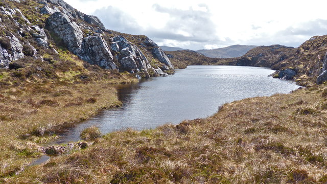
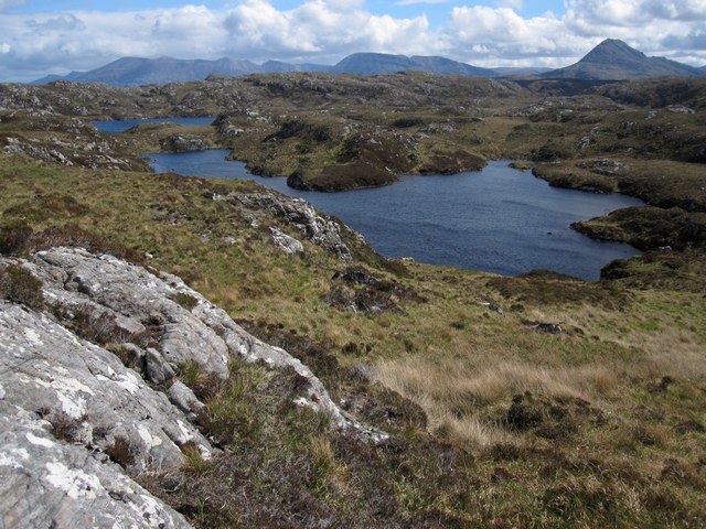
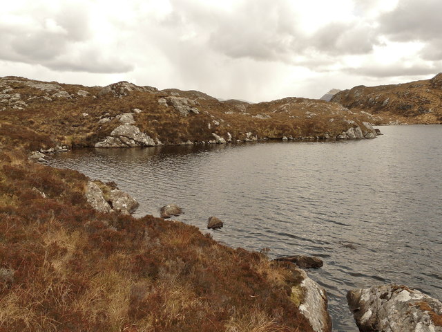
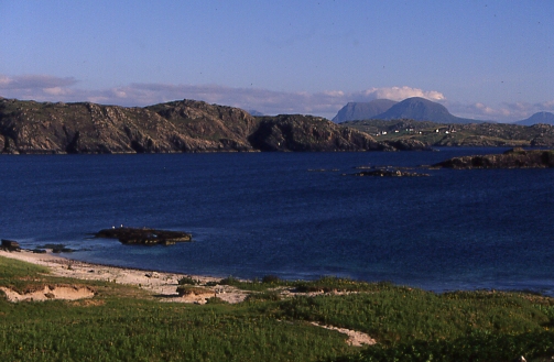
Situated near the village of Tongue, Cnoc Thormaid offers breathtaking panoramic views of the surrounding landscape. The hill is characterized by its rocky terrain, with heather and grass covering its slopes. At the summit, a trig point can be found, providing a marker for surveying and navigation purposes.

Access to Cnoc Thormaid is relatively straightforward, with a well-defined path leading up from the village of Tongue. The ascent is moderate, making it suitable for walkers of various abilities. The hill can be explored in approximately 2-3 hours, depending on one's pace and the amount of time spent enjoying the views.

The area surrounding Cnoc Thormaid is rich in natural beauty and wildlife. Visitors may encounter various bird species, including golden eagles and buzzards, as well as red deer and other mammals. The hill is also a popular spot for nature enthusiasts and photographers, offering ample opportunities to capture the stunning scenery.

Overall, Cnoc Thormaid is a captivating hill in Sutherland, attracting both locals and tourists alike. Its accessibility and remarkable views make it a popular destination for outdoor enthusiasts seeking a memorable experience in the Scottish Highlands.

If you have any feedback on the listing, please let us know in the comments section below.

Cnoc Thormaid Images

Images are sourced within 2km of 58.333364/-5.0940428 or Grid Reference NC1842. Thanks to Geograph Open Source API. All images are credited.

Lochan in possible Scourie dyke This part of the north west highlands is famous for its eponymous dykes. Confusingly the dykes here are horizontal depressions in the landscape rather than walls. Softer rock injected into a more resistant type has been eroded faster forming the long grooves across the countryside. See  <a href="https://www.geograph.org.uk/photo/7297313">NC1841 : Possible Scourie dyke</a> for an alternative view. The islands beyond are in Badcall Bay.
Lochan in possible Scourie dyke
This part of the north west highlands is famous for its eponymous dykes. Confusingly the dykes here are horizontal depressions in the landscape rather than walls. Softer rock injected into a more resistant type has been eroded faster forming the long grooves across the countryside. See NC1841 : Possible Scourie dyke for an alternative view. The islands beyond are in Badcall Bay.
Possible Scourie dyke The lochan in <a href="https://www.geograph.org.uk/photo/7297297">NC1841 : Lochan in possible Scourie dyke</a> seen from the west showing the distinctive steep sided edges of the gap.
Possible Scourie dyke
The lochan in NC1841 : Lochan in possible Scourie dyke seen from the west showing the distinctive steep sided edges of the gap.
Scourie dyke features The narrow, steep sided gully is charcteristic of Scourie dykes. This one is deep enough for the skyline notch to be shown on the larger scale OS map.
Scourie dyke features
The narrow, steep sided gully is charcteristic of Scourie dykes. This one is deep enough for the skyline notch to be shown on the larger scale OS map.
Approaching the Black Rock fishing beat This view is towards the exit burn of the most northerly loch in the Lochain na Creige Duibhe chain. This is one of the more remote fishing beats of the Scourie and District Angling Club. The view is from the eastern end of the gully shown in <a href="https://www.geograph.org.uk/photo/7297313">NC1841 : Possible Scourie dyke</a>. Ben Stack is the obvious conical background hill.
Approaching the Black Rock fishing beat
This view is towards the exit burn of the most northerly loch in the Lochain na Creige Duibhe chain. This is one of the more remote fishing beats of the Scourie and District Angling Club. The view is from the eastern end of the gully shown in NC1841 : Possible Scourie dyke. Ben Stack is the obvious conical background hill.
Lochain na Creige Duibhe This is the most southerly lochan in the Lochain na Creige Duibhe group. The eponymous crag is the background cliff. The shallow lochan contains water lilies as well as reeds which appear in the spring.
Lochain na Creige Duibhe
This is the most southerly lochan in the Lochain na Creige Duibhe group. The eponymous crag is the background cliff. The shallow lochan contains water lilies as well as reeds which appear in the spring.
Sutherland moorland Many lochans dot this landscape in the north west of Scotland.
Sutherland moorland
Many lochans dot this landscape in the north west of Scotland.
Lochan on Mnatha fishing beat This is the same lochan shown in <a href="https://www.geograph.org.uk/photo/2202611">NC2043 : Near Loch na Mnatha</a>. It is often the case that these small lochans can hold surprises for the angler
Lochan on Mnatha fishing beat
This is the same lochan shown in NC2043 : Near Loch na Mnatha. It is often the case that these small lochans can hold surprises for the angler
Loch Coill' a' Ghorm Locha This shows some of the wild country between Scourie and Ben Stack, the conical hill on the right.  The other background hills are the ridge of Foinaven on the left and Arkle in the centre.
Loch Coill' a' Ghorm Locha
This shows some of the wild country between Scourie and Ben Stack, the conical hill on the right. The other background hills are the ridge of Foinaven on the left and Arkle in the centre.
Loch na h-Airigh Slèibhe through a Scourie dyke Usually the rocks of volcanic intrusions are harder than the rock into which they are forced.  In the case of the Scourie dykes, the volcanic basalt is softer than the surrounding gneiss. This results in the basalt being eroded faster than the gneiss producing linear depressions in the landscape. The straight-sided trench running out into the loch is characteristic of these dykes.
Loch na h-Airigh Slèibhe through a Scourie dyke
Usually the rocks of volcanic intrusions are harder than the rock into which they are forced. In the case of the Scourie dykes, the volcanic basalt is softer than the surrounding gneiss. This results in the basalt being eroded faster than the gneiss producing linear depressions in the landscape. The straight-sided trench running out into the loch is characteristic of these dykes.
Loch an h-Airigh Slèibhe A view down the loch from the end of the Scourie dyke feature shown in <a href="https://www.geograph.org.uk/photo/2766912">NC1843 : Loch na h-Airigh Slèibhe through a Scourie dyke</a>
Loch an h-Airigh Slèibhe
A view down the loch from the end of the Scourie dyke feature shown in NC1843 : Loch na h-Airigh Slèibhe through a Scourie dyke
Assynt waymarker To the right of centre is an oar stuck into the peat as a waymarker for anglers making their way to some of the more remote lochs. See also <a href="https://www.geograph.org.uk/photo/4475453">NC1741 : Disappearing  Assynt waymarker</a>
Assynt waymarker
To the right of centre is an oar stuck into the peat as a waymarker for anglers making their way to some of the more remote lochs. See also NC1741 : Disappearing Assynt waymarker
Loch nan Uidh A wonderful spring day to be in the hills. As always, Ben Stack is unmistakable in the distance.
Loch nan Uidh
A wonderful spring day to be in the hills. As always, Ben Stack is unmistakable in the distance.
The course of Allt Loch na h-Airigh Slèibhe by Scourie The drainage here is rather complicated with three burns uniting within a hundred metres of each other just downstream of the dark nick of the nearest burn.
The course of Allt Loch na h-Airigh Slèibhe by Scourie
The drainage here is rather complicated with three burns uniting within a hundred metres of each other just downstream of the dark nick of the nearest burn.
Loch Bad an t-Seasgaich outlet burn This burn drains Loch Bad an t-Seasgaich in the middle of which, four grid squares meet.
Loch Bad an t-Seasgaich outlet burn
This burn drains Loch Bad an t-Seasgaich in the middle of which, four grid squares meet.
Loch Bad an t-Seasgaich Another of the four grid squares which meet in the middle of this loch ( <a href="https://www.geograph.org.uk/photo/2954942">NC1842 : Loch Bad an t-Seasgaich outlet burn</a> )
Loch Bad an t-Seasgaich
Another of the four grid squares which meet in the middle of this loch ( NC1842 : Loch Bad an t-Seasgaich outlet burn )
Loch Bad an t-Seasgaich The NC19 easting passes through the small promontory on the north shore of Loch Bad an t-Seasgaich. See also <a href="https://www.geograph.org.uk/photo/2954952">NC1843 : Loch Bad an t-Seasgaich</a>
Loch Bad an t-Seasgaich
The NC19 easting passes through the small promontory on the north shore of Loch Bad an t-Seasgaich. See also NC1843 : Loch Bad an t-Seasgaich
Loch Bad an t-Seasgaich Another square from the banks of the loch. See also <a href="https://www.geograph.org.uk/photo/2954952">NC1843 : Loch Bad an t-Seasgaich</a>  and  <a href="https://www.geograph.org.uk/photo/2954966">NC1943 : Loch Bad an t-Seasgaich</a>.
Loch Bad an t-Seasgaich
Another square from the banks of the loch. See also NC1843 : Loch Bad an t-Seasgaich and NC1943 : Loch Bad an t-Seasgaich.
Loch Bad an t-Seasgaich To complete the four grid squares on the banks of the loch! See also <a href="https://www.geograph.org.uk/photo/2954986">NC1942 : Loch Bad an t-Seasgaich</a> <a href="https://www.geograph.org.uk/photo/2954952">NC1843 : Loch Bad an t-Seasgaich</a> <a href="https://www.geograph.org.uk/photo/2954966">NC1943 : Loch Bad an t-Seasgaich</a>
Loch Bad an t-Seasgaich
To complete the four grid squares on the banks of the loch! See also NC1942 : Loch Bad an t-Seasgaich NC1843 : Loch Bad an t-Seasgaich NC1943 : Loch Bad an t-Seasgaich
Show me another place!

Cnoc Thormaid is located at Grid Ref: NC1842 (Lat: 58.333364, Lng: -5.0940428)

Unitary Authority: Highland

Police Authority: Highlands and Islands

What 3 Words

///spindles.innovate.defend. Near Oldshoremore, Highland

Related Wikis

Badcall, Scourie

Badcall comprises two remote hamlets, called Lower Badcall and Upper Badcall. Upper Badcall, a crofting township, is the larger of the two and is situated...

Scourie

Scourie (Scottish Gaelic: Sgobhairigh), historically spelled "Scoury", is a village on the north west coast of Scotland, about halfway between Ullapool...

Scourie F.C.

Scourie Football Club were a senior association football club from the village of Scourie in the Scottish Highlands. They competed in the North Caledonian...

Calbha Mòr

Calbha Mòr is a tidal islet in Eddrachillis Bay, Sutherland, Scotland. == Geography == Calbha Mòr lies north of the Kylesku Bridge and west of the Duartmore...

Have you been to Cnoc Thormaid?

Leave your review of Cnoc Thormaid below (or comments, questions and feedback).