Cnoc a' Ghlinnein

Hill, Mountain in Sutherland

Scotland

Cnoc a' Ghlinnein

One of the many waterfalls on the Allt an Tiaghaich The fine walk up to Loch a' Ghlinnein from Little Assynt follows the Allt an Tiaghaich. After crossing a flat grassy area between the road and the burn, the route takes you through a gorge before emerging onto a wider area with a series of waterfalls and inviting pools before the final pull up to the loch - highly recommended.
One of the many waterfalls on the Allt an Tiaghaich Credit: AlastairG

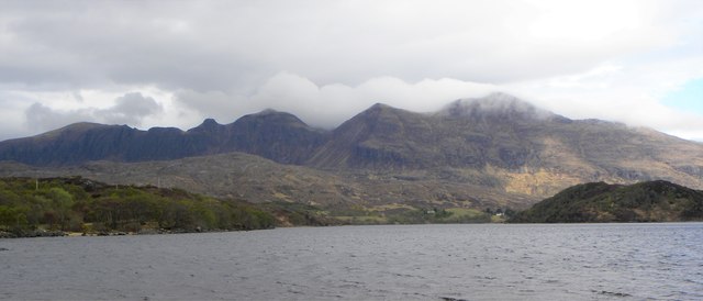
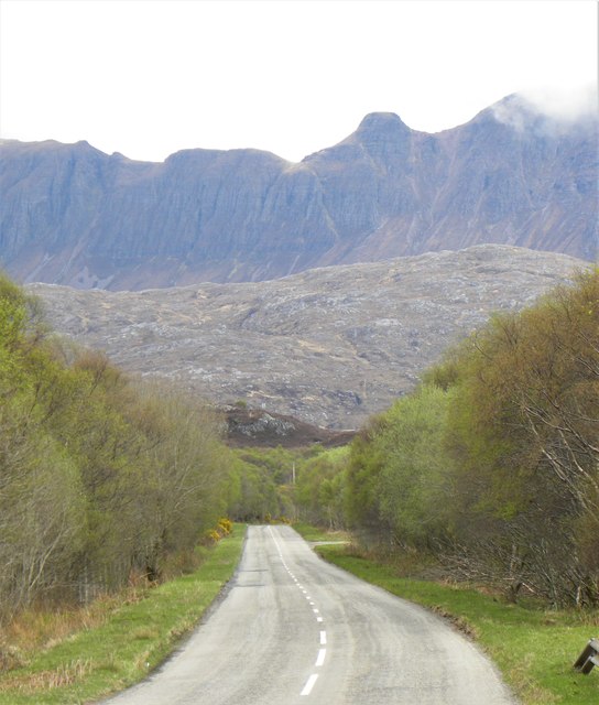
Cnoc a' Ghlinnein is a hill located in the remote and rugged landscape of Sutherland, Scotland. Standing at an impressive height of 699 meters (2293 feet), it offers stunning panoramic views of the surrounding countryside, including the nearby Ben Hope, the most northerly Munro in Scotland.

The hill is known for its challenging terrain, with steep slopes and rocky outcrops making it a popular destination for experienced hikers and climbers looking for a more challenging ascent. The summit of Cnoc a' Ghlinnein is marked by a cairn, providing a rewarding goal for those who reach the top.

The hill is surrounded by wild and unspoiled natural beauty, with heather-covered moorland and scattered lochs adding to its scenic appeal. Wildlife is abundant in the area, with red deer, golden eagles, and mountain hares frequently spotted in the vicinity.

Overall, Cnoc a' Ghlinnein offers outdoor enthusiasts a chance to experience the raw and untamed beauty of the Scottish Highlands, making it a must-visit destination for those seeking adventure in a truly remote and breathtaking landscape.

If you have any feedback on the listing, please let us know in the comments section below.

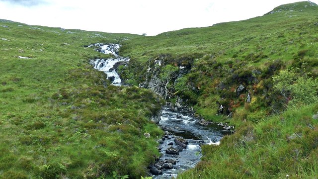
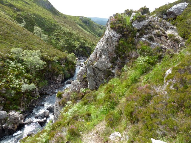
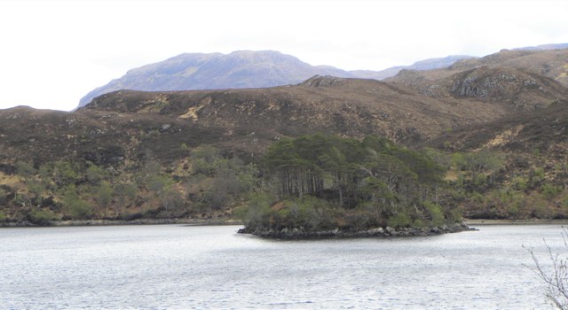
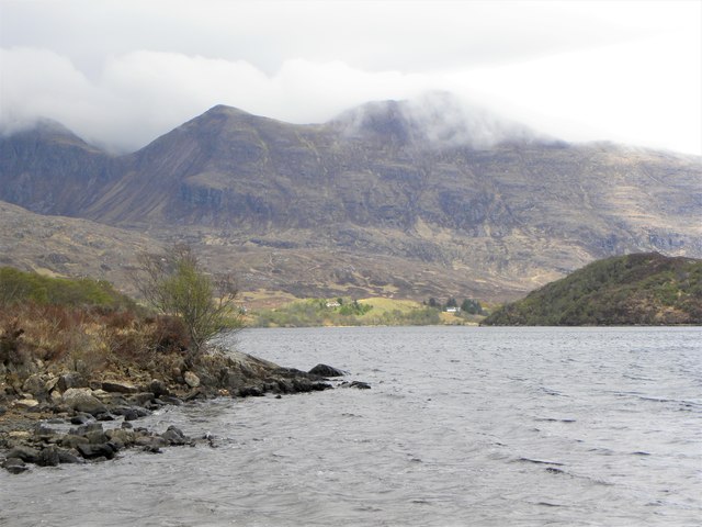
Cnoc a' Ghlinnein Images

Images are sourced within 2km of 58.166088/-5.1123494 or Grid Reference NC1723. Thanks to Geograph Open Source API. All images are credited.

One of the many waterfalls on the Allt an Tiaghaich The fine walk up to Loch a' Ghlinnein from Little Assynt follows the Allt an Tiaghaich. After crossing a flat grassy area between the road and the burn, the route takes you through a gorge before emerging onto a wider area with a series of waterfalls and inviting pools before the final pull up to the loch - highly recommended.
One of the many waterfalls on the Allt an Tiaghaich
The fine walk up to Loch a' Ghlinnein from Little Assynt follows the Allt an Tiaghaich. After crossing a flat grassy area between the road and the burn, the route takes you through a gorge before emerging onto a wider area with a series of waterfalls and inviting pools before the final pull up to the loch - highly recommended.
The upper reaches of the Allt an Tiaghaich This is the view looking upstream to the waterfall at the exit of the Allt an Tiaghaich from Loch a'Ghlinnein.
The upper reaches of the Allt an Tiaghaich
This is the view looking upstream to the waterfall at the exit of the Allt an Tiaghaich from Loch a'Ghlinnein.
Missing footbridges on the Allt an Tiaghaich This is where the burn leaves Loch a' Ghlinnein. One version of the OS map shows footbridges connecting the island shown here with both banks of the burn. There was no sign of any bridge on a recent visit. Since the path follows the right bank of the burn, you have to find two crossing points which will allow you to get on to the island then get off again to reach the left bank of the burn should you wish to fish the west side of Loch a' Ghlinnein. Wellies and trekking poles are very useful here!
Missing footbridges on the Allt an Tiaghaich
This is where the burn leaves Loch a' Ghlinnein. One version of the OS map shows footbridges connecting the island shown here with both banks of the burn. There was no sign of any bridge on a recent visit. Since the path follows the right bank of the burn, you have to find two crossing points which will allow you to get on to the island then get off again to reach the left bank of the burn should you wish to fish the west side of Loch a' Ghlinnein. Wellies and trekking poles are very useful here!
Loch a'Ghlinnein This is the view from where the burn leaves the loch. On the approach from the north, the loch isn't seen until you climb the last few feet beside the waterfall, when it suddenly appears rather like an Assynt infinity pool!
Loch a'Ghlinnein
This is the view from where the burn leaves the loch. On the approach from the north, the loch isn't seen until you climb the last few feet beside the waterfall, when it suddenly appears rather like an Assynt infinity pool!
Burn connecting Loch Fèith an Leòthaid and Loch a' Ghlinnein The burn isn't named on the OS map but it is a very attractive kilometre-long piece of water with several waterfalls and rapids to keep the attention of the walker and make him forget he's going uphill.
Burn connecting Loch Fèith an Leòthaid and Loch a' Ghlinnein
The burn isn't named on the OS map but it is a very attractive kilometre-long piece of water with several waterfalls and rapids to keep the attention of the walker and make him forget he's going uphill.
Assynt hill burn This connects Loch Fèith an Leòthaid with Loch a' Ghlinnein.
Assynt hill burn
This connects Loch Fèith an Leòthaid with Loch a' Ghlinnein.
Loch a' Ghlinnein feeder burn This burn keeps Loch a' Ghlinnein topped up. Its delta can be seen just to the right of centre.  The view is from the same spot as <a href="https://www.geograph.org.uk/photo/5017045">NC1723 : Assynt hill burn</a>
Loch a' Ghlinnein feeder burn
This burn keeps Loch a' Ghlinnein topped up. Its delta can be seen just to the right of centre. The view is from the same spot as NC1723 : Assynt hill burn
Loch Fèith an Leòthaid, Assynt The unnamed burn leaves Loch Fèith an Leòthaid on its way to Loch a' Ghlinnein and on to the River Inver. Canisp on the right and Beinn Reidh on the left frame the loch.
Loch Fèith an Leòthaid, Assynt
The unnamed burn leaves Loch Fèith an Leòthaid on its way to Loch a' Ghlinnein and on to the River Inver. Canisp on the right and Beinn Reidh on the left frame the loch.
Allt an Tiaghaich gorge, Assynt The narrowest part of the gorge is marked by a small crag which has to be climbed over to continue along the path.
Allt an Tiaghaich gorge, Assynt
The narrowest part of the gorge is marked by a small crag which has to be climbed over to continue along the path.
Allt an Tiaghaich gorge crux, Assynt This is the crag referred to in <a href="https://www.geograph.org.uk/photo/5017078">NC1623 : Allt an Tiaghaich gorge, Assynt</a>. The footpath can be seen crossing the crag at the top right of the photograph. Perhaps this has the greatest exposure but further up the gorge the path is probably more dangerous as parts of the underlying peat have broken away leaving gaps which can sometimes be hidden by heather or bracken.
Allt an Tiaghaich gorge crux, Assynt
This is the crag referred to in NC1623 : Allt an Tiaghaich gorge, Assynt. The footpath can be seen crossing the crag at the top right of the photograph. Perhaps this has the greatest exposure but further up the gorge the path is probably more dangerous as parts of the underlying peat have broken away leaving gaps which can sometimes be hidden by heather or bracken.
Eilean an Sgudain A small tree covered island in Loch Assynt. The OS map shows extensive tree cover on the hilly land on the far shore, but that doesn't exist apart from the usual stunted birch and willow.
Eilean an Sgudain
A small tree covered island in Loch Assynt. The OS map shows extensive tree cover on the hilly land on the far shore, but that doesn't exist apart from the usual stunted birch and willow.
Along Loch Assynt Looking north east along the loch towards Quinag.
Along Loch Assynt
Looking north east along the loch towards Quinag.
Loch Assynt A gravelly spit of land on the west side of Loch Assynt gives the chance for views along the loch towards the cloud capped peaks of Quinag.
Loch Assynt
A gravelly spit of land on the west side of Loch Assynt gives the chance for views along the loch towards the cloud capped peaks of Quinag.
The A837 by Loch Assynt A fine road running eastwards from Lochinver and re-engineered in the 1970's. Not a lot of traffic about on this occasion. The telephoto shot brings the frowning cliffs of Quinag into close view.
The A837 by Loch Assynt
A fine road running eastwards from Lochinver and re-engineered in the 1970's. Not a lot of traffic about on this occasion. The telephoto shot brings the frowning cliffs of Quinag into close view.
The River Inver Looking downstream from a footbridge at a point where the river slows and widens.
The River Inver
Looking downstream from a footbridge at a point where the river slows and widens.
Footbridge over the River Inver The stanchions and handrails are well past their best, whilst the deck is also the worse for wear. Still, it's a lot better than some footbridges I have crossed in the Highlands over the decades.
Footbridge over the River Inver
The stanchions and handrails are well past their best, whilst the deck is also the worse for wear. Still, it's a lot better than some footbridges I have crossed in the Highlands over the decades.
Road at Little Assynt On the Loch an t-Sabhail path as it nears the Field car park.
Road at Little Assynt
On the Loch an t-Sabhail path as it nears the Field car park.
Lochan an Iasgaich
Lochan an Iasgaich
Show me another place!

Cnoc a' Ghlinnein is located at Grid Ref: NC1723 (Lat: 58.166088, Lng: -5.1123494)

Unitary Authority: Highland

Police Authority: Highlands and Islands

What 3 Words

///suits.palace.snitch. Near Inchnadamph, Highland

Nearby Locations

Cnoc a' Ghlinnein

Related Wikis

Loch Leitir Easaidh

Loch Leitir Easaidh is a small shallow irregular shaped freshwater lochan that flows directly into the northwestern end of Loch Assynt in Assynt, Sutherland...

Assynt Castle

Assynt Castle was a castle, located on Eilean Assynt located in Loch Assynt, Highland in Scotland. == History == The Murray of Culbin family held lands...

Loch Beannach, Assynt

Loch Beannach is a small v-shaped loch, located 2 miles to the west of Loch Assynt and 3 miles northeast of Lochinver within the Assynt area of Sutherland...

Loch Assynt

Loch Assynt (Scottish Gaelic: Loch Asaint) is a freshwater loch in Sutherland, Scotland, 8 kilometres (5.0 mi) north-east of Lochinver. Situated in a spectacular...

Nearby Amenities

Located within 500m of 58.166088,-5.1123494
Cnoc a' Ghlinnein
Ele: 329
Ele Ft: 1081
Natural: peak
Lat/Long: 58.1681699/-5.1085502
The data included in this document is from www.openstreetmap.org. The data is made available under ODbL.

Have you been to Cnoc a' Ghlinnein?

Leave your review of Cnoc a' Ghlinnein below (or comments, questions and feedback).