Higher Denham

Settlement in Buckinghamshire

England

Higher Denham

Red Box, Yellow Van, Tilehouse Way A street scene in Denham Green.
Red Box, Yellow Van, Tilehouse Way Credit: Des Blenkinsopp

Higher Denham is a picturesque village located in the county of Buckinghamshire, England. Situated approximately 30 miles northwest of London, it falls within the South Bucks district. The village is nestled in the Chiltern Hills, offering stunning views of the surrounding countryside.

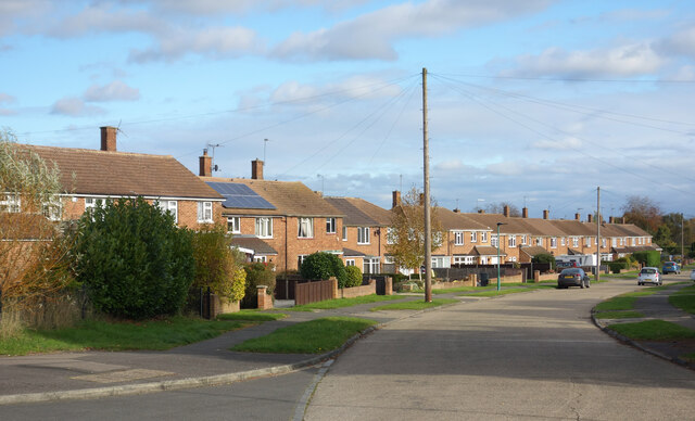
Higher Denham is a quiet and tranquil residential area, known for its charming character and close-knit community. The village is primarily made up of traditional English cottages and larger, more modern houses. The architecture reflects the area's rich history, with some buildings dating back to the 17th century.

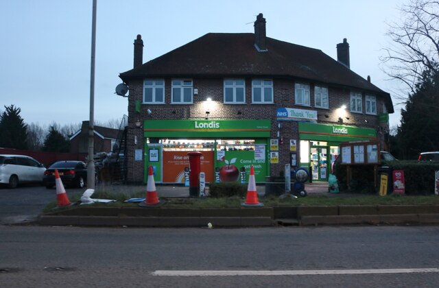
The village benefits from a range of local amenities, including a well-regarded primary school, a community center, a post office, and a local pub. Additionally, the neighboring town of Gerrards Cross is just a short distance away and provides a wider selection of shops, restaurants, and leisure facilities.

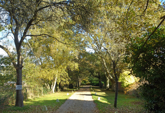
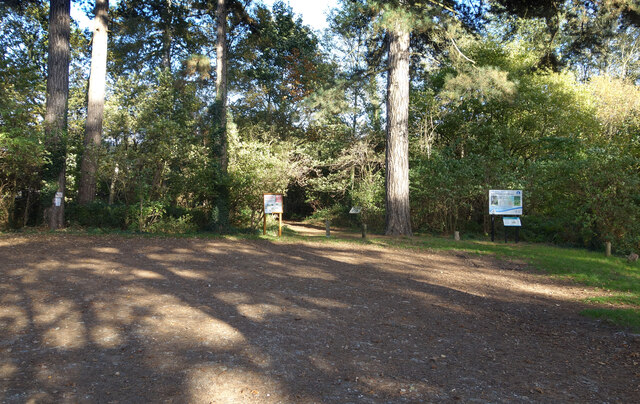
For nature enthusiasts, Higher Denham offers plenty of outdoor activities. The Chiltern Hills, designated an Area of Outstanding Natural Beauty, provide ample opportunities for hiking, cycling, and horseback riding. The area is also home to several nature reserves, including Denham Country Park, which features woodland, meadows, and a large lake.

Transport links are excellent, with easy access to the M40 and M25 motorways. The nearest railway station is Denham, providing regular services to London Marylebone in under 30 minutes.

Overall, Higher Denham offers a peaceful and idyllic countryside setting, while still providing convenient access to nearby towns and the bustling city of London.

If you have any feedback on the listing, please let us know in the comments section below.

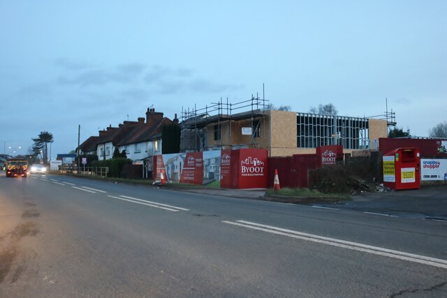
Higher Denham Images

Images are sourced within 2km of 51.578217/-0.518572 or Grid Reference TQ0287. Thanks to Geograph Open Source API. All images are credited.

Red Box, Yellow Van, Tilehouse Way A street scene in Denham Green.
Red Box, Yellow Van, Tilehouse Way
A street scene in Denham Green.
Tilehouse Way, Denham Green
Well Used Footpath In good condition and with the appearance of being in frequent use, a footpath beside the railway goes between the houses in Higher Denham and Denham Green. Farmland on this side of the line and a golf course on the other separate the two communities.
Well Used Footpath
In good condition and with the appearance of being in frequent use, a footpath beside the railway goes between the houses in Higher Denham and Denham Green. Farmland on this side of the line and a golf course on the other separate the two communities.
Denham Golf Club Station Opened in 1912 as a facility for the nearby golf club, the name has stayed. A suggestion in the 1950s to rename it Higher Denham after the small community nearby got turned down.
It would be interesting to know how many golfers, if any, still use the station.
Other people do. Over 30,000 a year at the last survey.  <span class="nowrap"><a title="https://en.wikipedia.org/wiki/Denham_Golf_Club_railway_station" rel="nofollow ugc noopener" href="https://en.wikipedia.org/wiki/Denham_Golf_Club_railway_station">Link</a><img style="margin-left:2px;" alt="External link" title="External link - shift click to open in new window" src="https://s1.geograph.org.uk/img/external.png" width="10" height="10"/></span>
Denham Golf Club Station
Opened in 1912 as a facility for the nearby golf club, the name has stayed. A suggestion in the 1950s to rename it Higher Denham after the small community nearby got turned down. It would be interesting to know how many golfers, if any, still use the station. Other people do. Over 30,000 a year at the last survey. LinkExternal link
Middle Road, Higher Denham A lot of thought went into naming the streets in the small community of Higher Denham on its hillside site.
Upper, Middle and Lower roads follow the contours of the valley side, while just round the corner from here the steeper Side Road follows the slope.
Middle Road, Higher Denham
A lot of thought went into naming the streets in the small community of Higher Denham on its hillside site. Upper, Middle and Lower roads follow the contours of the valley side, while just round the corner from here the steeper Side Road follows the slope.
Lower Road, Higher Denham A lot of thought went into naming the streets in the small community of Higher Denham on its hillside site.
Upper, Middle and Lower roads follow the contours of the valley side, while just a short way behind me here the steeper Side Road follows the slope.
Lower Road, Higher Denham
A lot of thought went into naming the streets in the small community of Higher Denham on its hillside site. Upper, Middle and Lower roads follow the contours of the valley side, while just a short way behind me here the steeper Side Road follows the slope.
Denham Golf Course "Denham Golf Club was founded in 1910 when the course was constructed and existing farm buildings dating back to the 16th Century were converted into a clubhouse." - club site.
Nice autumn colours on a clump of trees near the club house.
Denham Golf Course
"Denham Golf Club was founded in 1910 when the course was constructed and existing farm buildings dating back to the 16th Century were converted into a clubhouse." - club site. Nice autumn colours on a clump of trees near the club house.
Entrance to Denham Golf Club
Over The Misbourne Road A leafy private road with prosperous housing. Also a public bridleway.
Over The Misbourne Road
A leafy private road with prosperous housing. Also a public bridleway.
Mirrie Lane, Denham An unsurfaced private road to three or four houses on the edge of Denham Airfield.
Mirrie Lane, Denham
An unsurfaced private road to three or four houses on the edge of Denham Airfield.
Hangars at Denham Aerodrome According to Wikipedia <span class="nowrap"><a title="https://en.wikipedia.org/wiki/Denham_Aerodrome#History" rel="nofollow ugc noopener" href="https://en.wikipedia.org/wiki/Denham_Aerodrome#History">Link</a><img style="margin-left:2px;" alt="External link" title="External link - shift click to open in new window" src="https://s1.geograph.org.uk/img/external.png" width="10" height="10"/></span> there are records of flying from here since the 1900s. The airfield was used in both world wars and is still busy with training, filming and helicopter maintenance.
Hangars at Denham Aerodrome
According to Wikipedia LinkExternal link there are records of flying from here since the 1900s. The airfield was used in both world wars and is still busy with training, filming and helicopter maintenance.
Northmoor Hill Wood A woodland nature reserve, part of the Colne Valley Regional Park. <span class="nowrap"><a title="https://www.woodlandtrust.org.uk/visiting-woods/woods/northmoor-hill-wood/" rel="nofollow ugc noopener" href="https://www.woodlandtrust.org.uk/visiting-woods/woods/northmoor-hill-wood/">Link</a><img style="margin-left:2px;" alt="External link" title="External link - shift click to open in new window" src="https://s1.geograph.org.uk/img/external.png" width="10" height="10"/></span>
Northmoor Hill Wood
A woodland nature reserve, part of the Colne Valley Regional Park. LinkExternal link
Farmland by Marish Lane This is a very Town and Country area, with tracts of rural farmland side by side with 20th century suburban development.
Farmland by Marish Lane
This is a very Town and Country area, with tracts of rural farmland side by side with 20th century suburban development.
Pond in the Woods A secluded pond along Marish Lane.
Pond in the Woods
A secluded pond along Marish Lane.
Marish Lane An unsurfaced woodland bridleway.
Marish Lane
An unsurfaced woodland bridleway.
Over The Misbourne A private road called Over The Misbourne, a river which it does indeed cross, about where the fence ends mid picture.
It also goes over the M25, but that somehow doesn't sound quite as appealing.
Over The Misbourne
A private road called Over The Misbourne, a river which it does indeed cross, about where the fence ends mid picture. It also goes over the M25, but that somehow doesn't sound quite as appealing.
Londis on Oxford Road, Denham Londis is short for London Independent Supermarkets
Londis on Oxford Road, Denham
Londis is short for London Independent Supermarkets
Oxford Road, Denham
Oxford Road, Denham
Show me another place!

Higher Denham is located at Grid Ref: TQ0287 (Lat: 51.578217, Lng: -0.518572)

Unitary Authority: Buckinghamshire

Police Authority: Thames Valley

What 3 Words

///deputy.month.dome. Near Denham, Buckinghamshire

Related Wikis

Denham Golf Club railway station

Denham Golf Club railway station is a railway station near the villages of Baker's Wood and Denham, Buckinghamshire, England. The station is on the Chiltern...

Old Rectory Meadows

Old Rectory Meadows is a 7.9-hectare (20-acre) Site of Special Scientific Interest in Denham in Buckinghamshire.This site on the bank of the River Misbourne...

Baker's Wood

Baker's Wood is a hamlet 2 miles west of Denham (where at the 2011 Census the population was included) off the A40 in Buckinghamshire, England. The hamlet...
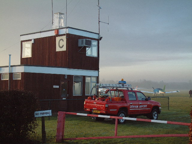
Denham Aerodrome

Denham Aerodrome (ICAO: EGLD) is an operational general aviation aerodrome located 1.5 NM (2.8 km; 1.7 mi) east of Gerrards Cross, near Denham, Buckinghamshire...

Nearby Amenities

Located within 500m of 51.578217,-0.518572
Denham Golf Club
Naptan AtcoCode: 9100DENHMGC
Network: National Rail
Network Website: https://www.nationalrail.co.uk/stations/dgc/
Network Wikidata: Q26334
Operator: Chiltern Railways
Public Transport: station
Railway: station
Ref Crs: DGC
Wheelchair: no
Wikidata: Q2521362
Wikipedia: en:Denham Golf Club railway station
Lat/Long: 51.5806166/-0.5181943
Power: tower
Lat/Long: 51.574938/-0.5136833
Power: tower
Lat/Long: 51.575573/-0.5177869
Power: tower
Lat/Long: 51.5763145/-0.5225299
Barrier: stile
Lat/Long: 51.5754353/-0.5197711
Higher Denham
Place: village
Lat/Long: 51.5786031/-0.5185016
Direction: 170
Generator Method: photovoltaic
Generator Output Electricity: yes
Generator Solar Modules: 270
Generator Source: solar
Generator Type: solar_photovoltaic_panel
Location: roof
Power: generator
Tilt: 10
Lat/Long: 51.5787493/-0.5250985
Direction: 170
Generator Method: photovoltaic
Generator Output Electricity: yes
Generator Solar Modules: 269
Generator Source: solar
Generator Type: solar_photovoltaic_panel
Location: roof
Power: generator
Tilt: 10
Lat/Long: 51.5785551/-0.5250945
Direction: 170
Generator Method: photovoltaic
Generator Output Electricity: yes
Generator Solar Modules: 6
Generator Source: solar
Generator Type: solar_photovoltaic_panel
Location: roof
Power: generator
Lat/Long: 51.5786728/-0.5246225
Direction: 170
Generator Method: photovoltaic
Generator Output Electricity: yes
Generator Solar Modules: 8
Generator Source: solar
Generator Type: solar_photovoltaic_panel
Location: roof
Power: generator
Lat/Long: 51.5787137/-0.524477
Fixme: survey to check for tilt & direction
Generator Method: photovoltaic
Generator Output Electricity: yes
Generator Solar Modules: 16
Generator Source: solar
Generator Type: solar_photovoltaic_panel
Location: roof
Power: generator
Tilt: no
Lat/Long: 51.5798022/-0.5220443
Direction: 280
Generator Method: photovoltaic
Generator Output Electricity: yes
Generator Solar Modules: 16
Generator Source: solar
Generator Type: solar_photovoltaic_panel
Location: roof
Power: generator
Lat/Long: 51.5798221/-0.5224032
Direction: 200
Generator Method: photovoltaic
Generator Output Electricity: yes
Generator Solar Modules: 20
Generator Source: solar
Generator Type: solar_photovoltaic_panel
Location: roof
Power: generator
Lat/Long: 51.5741926/-0.5157788
Direction: 200
Generator Method: photovoltaic
Generator Output Electricity: yes
Generator Solar Modules: 16
Generator Source: solar
Generator Type: solar_photovoltaic_panel
Location: roof
Power: generator
Lat/Long: 51.574917/-0.523229
Bus Stop
Community Centre
Physically Present: no
Public Transport: platform
Lat/Long: 51.578552/-0.5160296
Access: yes
Leisure: pitch
Lit: no
Sport: basketball
Lat/Long: 51.5781392/-0.5146656
Denham PCP 4
Colour: green
Man Made: street_cabinet
Operator: Openreach
Operator Wikidata: Q7096543
Ref: 4
Street Cabinet: telecom
Telecom: connection_point
Telecom Medium: copper
Utility: telecom
Lat/Long: 51.579547/-0.515933
Defibrillator
Access: yes
Booth: KX100
Covered: booth
Defibrillator Location: inside old phone box, Upper Road, Higher Denham
Disused Amenity: telephone
Emergency: defibrillator
Man Made: telephone_box
Ref GB The Circuit: FD0AF408-D098-4316-8744-AFE800A6A6F6
Lat/Long: 51.5802933/-0.5169928
Power: substation
Lat/Long: 51.5803289/-0.5169562
The data included in this document is from www.openstreetmap.org. The data is made available under ODbL.

Have you been to Higher Denham?

Leave your review of Higher Denham below (or comments, questions and feedback).