Am Baile Meadhanach

Settlement in Inverness-shire

Scotland

Am Baile Meadhanach

Sconser Pier and Ferry
Sconser Pier and Ferry Credit: N Chadwick

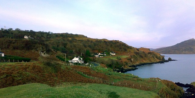
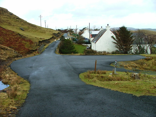
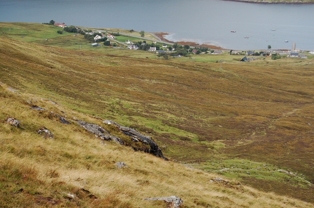
Am Baile Meadhanach is a small village located in Inverness-shire, Scotland. It is nestled in the picturesque Scottish Highlands, surrounded by lush green hills and breathtaking landscapes. The village is situated approximately 15 miles southwest of Inverness, the capital of the Highlands.

Am Baile Meadhanach is known for its tranquility and natural beauty, making it an ideal destination for nature enthusiasts and those seeking a peaceful retreat. The village offers a variety of outdoor activities, including hiking, fishing, and wildlife spotting. The nearby Glen Affric, one of Scotland's most stunning glens, is a popular spot for outdoor enthusiasts and offers spectacular views of mountains, lochs, and ancient Caledonian forests.

In terms of amenities, Am Baile Meadhanach has a small but friendly community. The village has a local grocery store, a pub, and a post office, providing essential services to its residents and visitors. The locals are known for their warm hospitality and welcoming nature, ensuring that visitors feel at home during their stay.

For those interested in history and culture, the area surrounding Am Baile Meadhanach offers numerous historical landmarks and attractions. Urquhart Castle, located on the banks of Loch Ness, is a short drive away and provides a glimpse into Scotland's rich medieval heritage. Additionally, the village is within reach of the famous Culloden Battlefield, where the historic Battle of Culloden took place in 1746.

Overall, Am Baile Meadhanach is a hidden gem in the Scottish Highlands, offering a perfect blend of natural beauty, outdoor activities, and Scottish charm.

If you have any feedback on the listing, please let us know in the comments section below.

Am Baile Meadhanach Images

Images are sourced within 2km of 57.33196/-6.109529 or Grid Reference NG5234. Thanks to Geograph Open Source API. All images are credited.

Sconser Pier and Ferry
Pier, slipway and ferry at Sconser The ferry waiting to travel to Raasay as it was on the morning of 23 August 1995 when to make the crossing to the island with three people in the car, we paid £16.50. There was room for three cars, a coal lorry and very little more. Little has changed in the view since that time: the current ferry is larger and so of course will be the cost involved!
The location at the far shore of Loch Sligachan is not of course the island of Raasay but ground which rises to Ben Lee.
Pier, slipway and ferry at Sconser
The ferry waiting to travel to Raasay as it was on the morning of 23 August 1995 when to make the crossing to the island with three people in the car, we paid £16.50. There was room for three cars, a coal lorry and very little more. Little has changed in the view since that time: the current ferry is larger and so of course will be the cost involved! The location at the far shore of Loch Sligachan is not of course the island of Raasay but ground which rises to Ben Lee.
Camas a' Mhòr-bheòil Looking north from the beach towards Ben Tianavaig.
Camas a' Mhòr-bheòil
Looking north from the beach towards Ben Tianavaig.
Moorings at Sconser Looking over Loch Sligachan from the Sconser/Raasay ferry terminal to the eastern end of Ben Lee.
Moorings at Sconser
Looking over Loch Sligachan from the Sconser/Raasay ferry terminal to the eastern end of Ben Lee.
Pier at Sconser/Sgonnsair Adjacent to the Raasay ferry terminal on Loch Sligachan.
Pier at Sconser/Sgonnsair
Adjacent to the Raasay ferry terminal on Loch Sligachan.
The Raasay ferry, 'Hallaig' Arriving at Sconser/Sgonnsair. Apparently the world’s first sea-going, roll-on/roll-off, vehicle and passenger diesel electric hybrid ship - and very smooth and quiet it is.
The Raasay ferry, 'Hallaig'
Arriving at Sconser/Sgonnsair. Apparently the world’s first sea-going, roll-on/roll-off, vehicle and passenger diesel electric hybrid ship - and very smooth and quiet it is.
Approaching Sconser/Sgonnsair On the ferry 'Hallaig' from Raasay.
Approaching Sconser/Sgonnsair
On the ferry 'Hallaig' from Raasay.
Southwards from An Aird Looking across the tombolo and Balmeanach Bay towards Glamaig.
Southwards from An Aird
Looking across the tombolo and Balmeanach Bay towards Glamaig.
Loch an Amadain Looking north from An Aird towards Ben Tianavaig, with The Storr in the far distance.
Loch an Amadain
Looking north from An Aird towards Ben Tianavaig, with The Storr in the far distance.
Shoreline rocks, An Aird
Peinachorrain Almost the end of the Braes road.
Looking across the mouth of Loch Sligachan, showing the spit Rubha an Tòrra Mhòir and Sgeir Dhubh.
The hill in the background is Meall a' Mhaoil, with Sconser Quarry visible.
Peinachorrain
Almost the end of the Braes road. Looking across the mouth of Loch Sligachan, showing the spit Rubha an Tòrra Mhòir and Sgeir Dhubh. The hill in the background is Meall a' Mhaoil, with Sconser Quarry visible.
Balmeanach Looking south over Balmeanach Bay, to the headland Tòrr Mòr (in the centre).
The hill to the left is Meall a' Mhaoil, with Sconser Quarry just visible.
The red hills are beyond.
Balmeanach
Looking south over Balmeanach Bay, to the headland Tòrr Mòr (in the centre). The hill to the left is Meall a' Mhaoil, with Sconser Quarry just visible. The red hills are beyond.
Shore at the Braes Looking north from above the beach towards Ben Tianavaig.
Camas a' Mhòr-bheòil extends to the right (east).
Sheep are grazing the steep slopes.
Shore at the Braes
Looking north from above the beach towards Ben Tianavaig. Camas a' Mhòr-bheòil extends to the right (east). Sheep are grazing the steep slopes.
Rubha an Tòrra Mhòir Looking ashore from the Isle of Raasay ferry.
Rubha an Tòrra Mhòir
Looking ashore from the Isle of Raasay ferry.
Peinachorrain and the eastern slope of Ben Lee Looking across the shingle spit of Rubha an Tòrra Mhòir from the Isle of Raasay ferry.
Peinachorrain and the eastern slope of Ben Lee
Looking across the shingle spit of Rubha an Tòrra Mhòir from the Isle of Raasay ferry.
Balmeanach Bay The north side of the bay is a low-lying spit, and in the background are the lava cliffs north of Portree.
Balmeanach Bay
The north side of the bay is a low-lying spit, and in the background are the lava cliffs north of Portree.
Cautionary signs at Sconser Ferry Terminal
Sconser Pier: early April 2018
Show me another place!

Am Baile Meadhanach is located at Grid Ref: NG5234 (Lat: 57.33196, Lng: -6.109529)

Unitary Authority: Highland

Police Authority: Highlands and Islands

Also known as: Balmeanach

What 3 Words

///walls.edgy.liner. Near Portree, Highland

Related Wikis

Gedintailor

Gedintailor (Scottish Gaelic: Gead an t-Sailleir) is a crofting village, lying on the shores of the Narrows of Raasay on the east coast of the island of...

Peinachorran

Peinchorran (Scottish Gaelic: Peighinn a' Chorrain; Peinachorrain on Ordnance Survey maps) is a remote settlement, lying at the end of the B883 road, on...

Sconser

Sconser (Scottish Gaelic: Sgonnsair) is a small crofting township on the island of Skye, in Scotland, situated on the south shore of Loch Sligachan. The...

Ollach

Ollach (in Scottish Gaelic, An t-Olach) is a remote settlement, made up of Lower Ollach and Upper Ollach, lying on B883 road, south of Portree, Isle of...

Nearby Amenities

Located within 500m of 57.33196,-6.109529
Source: PGS
Lat/Long: 57.328157/-6.1057773
Source: PGS
Lat/Long: 57.328687/-6.1057462
Source: PGS
Lat/Long: 57.3287497/-6.1066697
Source: PGS
Lat/Long: 57.3304445/-6.1072211
Source: PGS
Lat/Long: 57.3308159/-6.106968
Source: PGS
Lat/Long: 57.3311945/-6.1069603
Source: PGS
Lat/Long: 57.3317604/-6.1069795
Source: PGS
Lat/Long: 57.3326224/-6.106233
Source: PGS
Lat/Long: 57.3329116/-6.105878
Source: PGS
Lat/Long: 57.3337572/-6.1055361
Source: PGS
Lat/Long: 57.3339189/-6.1058928
Source: PGS
Lat/Long: 57.3341724/-6.1064672
Source: PGS
Lat/Long: 57.3352416/-6.1067525
Source: PGS
Lat/Long: 57.3357976/-6.1060134
Passing Place
Lat/Long: 57.3305351/-6.1093493
Balmeanach
Name Gd: Am Baile Meadhanach
Place: hamlet
Lat/Long: 57.3330346/-6.1102012
Power: pole
Lat/Long: 57.3283978/-6.1140794
Power: pole
Lat/Long: 57.3290406/-6.1145246
Power: pole
Lat/Long: 57.3298992/-6.1151281
Power: pole
Lat/Long: 57.330474/-6.1155438
Power: pole
Lat/Long: 57.3309605/-6.1159059
Power: pole
Lat/Long: 57.3319971/-6.1166248
Power: pole
Lat/Long: 57.3326892/-6.1170968
Power: pole
Lat/Long: 57.3350851/-6.1141813
Power: pole
Lat/Long: 57.3343613/-6.1142505
Power: pole
Lat/Long: 57.3332958/-6.1142886
Passing Place
Lat/Long: 57.3295431/-6.1092836
Power: pole
Lat/Long: 57.3327554/-6.1143793
Power: pole
Lat/Long: 57.3319414/-6.1138
Power: pole
Lat/Long: 57.3309404/-6.1131071
Power: pole
Lat/Long: 57.3304344/-6.1127345
Power: pole
Lat/Long: 57.3296911/-6.1121886
Power: pole
Lat/Long: 57.3291182/-6.1120518
Power: pole
Lat/Long: 57.3284731/-6.1118757
Power: pole
Lat/Long: 57.3294695/-6.111158
Power: pole
Lat/Long: 57.3292267/-6.1100692
Power: pole
Lat/Long: 57.3294396/-6.1094593
Power: pole
Lat/Long: 57.3278461/-6.1116966
Power: pole
Lat/Long: 57.3274972/-6.1105569
Power: pole
Lat/Long: 57.334978/-6.1118575
Power: pole
Lat/Long: 57.3337649/-6.1116595
Power: pole
Lat/Long: 57.3326383/-6.1101282
Power: pole
Lat/Long: 57.3317096/-6.1098618
Power: pole
Lat/Long: 57.3312107/-6.1096056
Power: pole
Lat/Long: 57.33419/-6.1132083
Power: pole
Lat/Long: 57.3340847/-6.1125969
Power: pole
Lat/Long: 57.3339582/-6.1122388
Power: pole
Lat/Long: 57.3348617/-6.1126086
Power: pole
Lat/Long: 57.3351005/-6.1111399
Passing Place
Lat/Long: 57.3285921/-6.1086363
Access Cattle: no
Barrier: cattle_grid
Lat/Long: 57.3284085/-6.1084322
Turning Circle
Lat/Long: 57.3347768/-6.1107011
Passing Place
Lat/Long: 57.3350416/-6.11155
The data included in this document is from www.openstreetmap.org. The data is made available under ODbL.

Have you been to Am Baile Meadhanach?

Leave your review of Am Baile Meadhanach below (or comments, questions and feedback).