Brown Hill

Hill, Mountain in Wigtownshire

Scotland

Brown Hill

Looking Over The Main Water of Luce Dalnigap Farm on the other side.
Looking Over The Main Water of Luce Credit: Jon Alexander

Brown Hill is a prominent hill located in the region of Wigtownshire, in southwest Scotland. Rising to an elevation of approximately 1,240 feet (378 meters), it offers breathtaking panoramic views of the surrounding landscape. The hill is situated near the small village of Monreith, just a few miles from the coast of the North Atlantic Ocean.

With its distinctive brownish hue, Brown Hill gets its name from the color of the heather and grass that covers its slopes. It is primarily composed of granite and stands as a notable landmark in the area. The hill is accessible via various footpaths and trails, making it a popular destination for hikers and nature enthusiasts.

The summit of Brown Hill provides awe-inspiring vistas of the surrounding countryside, including the nearby Galloway Hills and the picturesque coastline. On a clear day, it is even possible to catch a glimpse of the Isle of Man in the distance.

The hill is home to a diverse range of flora and fauna, with heather, grasses, and wildflowers carpeting its slopes. Birdwatchers may spot a variety of species, including red grouse, skylarks, and peregrine falcons soaring above.

Brown Hill offers opportunities for outdoor activities such as hillwalking, photography, and wildlife observation. Its tranquil and unspoiled surroundings make it an ideal spot for those seeking a peaceful retreat amidst the natural beauty of Wigtownshire.

If you have any feedback on the listing, please let us know in the comments section below.

Brown Hill Images

Images are sourced within 2km of 54.984605/-4.9130195 or Grid Reference NX1369. Thanks to Geograph Open Source API. All images are credited.
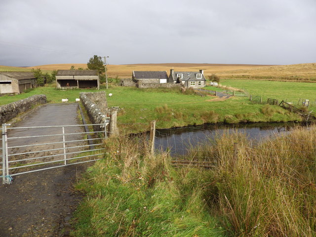
Looking Over The Main Water of Luce Dalnigap Farm on the other side.
Looking Over The Main Water of Luce
Dalnigap Farm on the other side.
Penwhirn Reservoir near Stranraer Penwhirn Reservoir is the source of the drinking water for the Stranraer area. It was formed from the Penwhirn Burn in the 1950's and the water treatment plant established in 1955.
Penwhirn Reservoir near Stranraer
Penwhirn Reservoir is the source of the drinking water for the Stranraer area. It was formed from the Penwhirn Burn in the 1950's and the water treatment plant established in 1955.
Track to Loch Ree This is the only access to the fishing loch of Loch Ree which lies some 2 km from the Innermessan to Penwhirn road
Track to Loch Ree
This is the only access to the fishing loch of Loch Ree which lies some 2 km from the Innermessan to Penwhirn road
Diddles Hill A singularly featureless stretch of extremely damp, tussocky moorland
Diddles Hill
A singularly featureless stretch of extremely damp, tussocky moorland
Moorland off the New Luce to Penwhirn road
Penwhirn Filter Station Established in 1955 (although the buildings in view are newer than that) in conjunction with the Penwhirn Reservoir to supply water to the Stranraer district.
Penwhirn Filter Station
Established in 1955 (although the buildings in view are newer than that) in conjunction with the Penwhirn Reservoir to supply water to the Stranraer district.
Main Water of Luce Defunct bridge was shown as open on the 1995 Landranger map.
Main Water of Luce
Defunct bridge was shown as open on the 1995 Landranger map.
High Mark, near Stranraer This former farmhouse is now a holiday cottage.
High Mark, near Stranraer
This former farmhouse is now a holiday cottage.
Dalnigap Farm, near Stranraer
Diddles Hill The van is parked at the nearest access for the 2Km trek into the fishing loch of Loch Ree.
Diddles Hill
The van is parked at the nearest access for the 2Km trek into the fishing loch of Loch Ree.
Penwhirn Reservoir Constructed in the 1950s to supply the Stranraer district with drinking water. Extensive forestry plantations extend from the northern shore.
Penwhirn Reservoir
Constructed in the 1950s to supply the Stranraer district with drinking water. Extensive forestry plantations extend from the northern shore.
Moorland road from New Luce to Penwhirn
Wash water holding tanks at Penwhirn Part of the installation below Penwhirn Reservoir to supply the Stranraer district with drinking water.
Wash water holding tanks at Penwhirn
Part of the installation below Penwhirn Reservoir to supply the Stranraer district with drinking water.
Bridge over Penwhirn Burn Just below Penwhirn Reservoir. The road to the right follows the Water of Luce to terminate at Lagafater Lodge [<a href="https://www.geograph.org.uk/gridref/NX1376">NX1376</a>].
Bridge over Penwhirn Burn
Just below Penwhirn Reservoir. The road to the right follows the Water of Luce to terminate at Lagafater Lodge [NX1376].
Monumental architecture at Penwhirn Filter Station Built in 1955 to provide the Stranraer district with drinking water.
Monumental architecture at Penwhirn Filter Station
Built in 1955 to provide the Stranraer district with drinking water.
Fields near Cairnerzean Looking down into the valley of the Water of Luce
Fields near Cairnerzean
Looking down into the valley of the Water of Luce
Old roadside quarry near Pularyan
Excavations at Pularyan Not too sure what is going on here.
Excavations at Pularyan
Not too sure what is going on here.
Show me another place!

Brown Hill is located at Grid Ref: NX1369 (Lat: 54.984605, Lng: -4.9130195)

Unitary Authority: Dumfries and Galloway

Police Authority: Dumfries and Galloway

What 3 Words

///awards.multiply.reinvest. Near Cairnryan, Dumfries & Galloway

Nearby Locations

Brown Hill

Related Wikis

Loups of Dalnigap

Loups of Dalnigap is a waterfall of Scotland. It sits below Dalnigap House, in the South of the Lagafater Estate. == See also == Waterfalls of Scotland...

Penwhirn Reservoir

Penwhirn Reservoir, is a reservoir in Dumfries and Galloway, Scotland, approximately 3.5 miles (6 km) east of Cairnryan. The reservoir was built in the...

Glenwhilly railway station

Glenwhilly railway station served the area of Glenwhilly, Dumfries and Galloway, Scotland from 1887 to 1965 on the Girvan and Portpatrick Junction Railway...

Inch, Dumfries and Galloway

Inch is a civil parish in Dumfries and Galloway, southwest Scotland. It lies on the shore of Loch Ryan, in the traditional county of Wigtownshire.The...

New Luce railway station

New Luce railway station served the village of New Luce, Dumfries and Galloway, Scotland from 1887 to 1965 on the Girvan and Portpatrick Junction Railway...

New Luce

New Luce (Scottish Gaelic: Baile Ùr Ghlinn Lus) is a civil parish in Dumfries and Galloway, south-west Scotland. It lies in the traditional county of Wigtownshire...

The Lagafater Estate

Lagafater is a 7000-acre (2832.8 ha) former sporting estate near New Luce in Dumfries and Galloway, Scotland. Since 1910 it has been in the family of its...

Cairnryan

Cairnryan (Scots: The Cairn; Scottish Gaelic: Càrn Rìoghain or Machair an Sgithich) is a village in the historical county of Wigtownshire, Dumfries and...

Nearby Amenities

Located within 500m of 54.984605,-4.9130195
Dunnerum
Place: locality
Source: OSODSV
Lat/Long: 54.9860747/-4.9128132
Dalhabboch Bridge
Place: locality
Source: OSODSV
Lat/Long: 54.9856976/-4.9172093
Power: pole
Lat/Long: 54.9846234/-4.9164315
Power: pole
Lat/Long: 54.985208/-4.9163635
Power: pole
Lat/Long: 54.9860796/-4.9166241
Power: pole
Lat/Long: 54.9867032/-4.9168001
Power: pole
Lat/Long: 54.9873147/-4.9169645
Power: pole
Lat/Long: 54.9879707/-4.9171593
Power: pole
Lat/Long: 54.9805767/-4.9137858
Power: pole
Lat/Long: 54.981098/-4.9145276
Power: pole
Lat/Long: 54.9817837/-4.9155207
Power: pole
Lat/Long: 54.982301/-4.9162954
Power: pole
Lat/Long: 54.98279/-4.9169645
Power: pole
Lat/Long: 54.9833181/-4.9177955
Power: pole
Lat/Long: 54.9837828/-4.918481
Power: pole
Lat/Long: 54.9807383/-4.9155559
The data included in this document is from www.openstreetmap.org. The data is made available under ODbL.

Have you been to Brown Hill?

Leave your review of Brown Hill below (or comments, questions and feedback).