Mynydd-bach

Hill, Mountain in Pembrokeshire

Wales

Mynydd-bach

Stile and path towards Foel Cwmcerwyn
Stile and path towards Foel Cwmcerwyn Credit: Alan Hughes

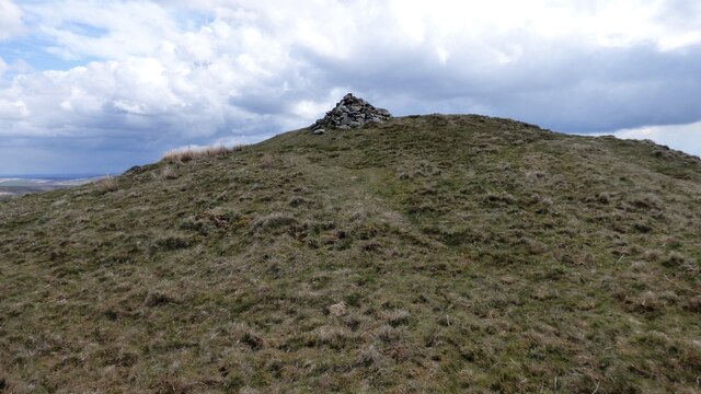
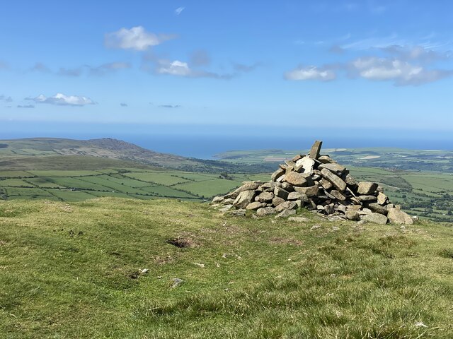
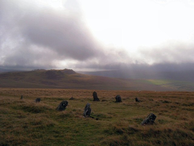
Mynydd-bach, located in the county of Pembrokeshire, Wales, is a prominent hill or mountain that offers stunning natural beauty and recreational opportunities for visitors and locals alike. With an elevation of approximately 314 meters (1,030 feet), it stands as one of the higher peaks in the region and provides breathtaking panoramic views of the surrounding countryside.

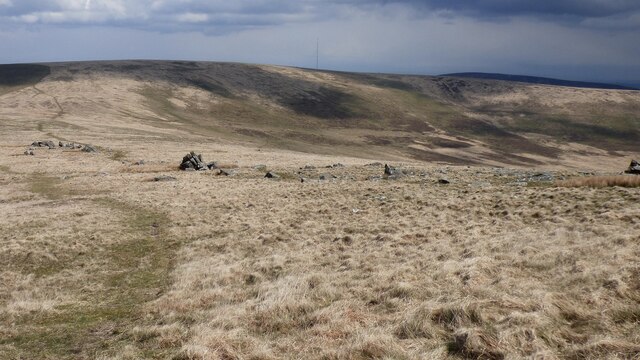
The hill is characterized by its diverse landscape, featuring grassy slopes, rocky outcrops, and patches of heather. It is home to a variety of flora and fauna, including wildflowers, birds, and small mammals, making it a popular destination for nature enthusiasts and wildlife photographers.

There are numerous walking trails and footpaths that lead to the summit of Mynydd-bach, catering to both casual strollers and more experienced hikers. These routes offer a range of difficulty levels, allowing visitors to choose the one that suits their preferences and abilities. Along the way, walkers can enjoy the tranquil atmosphere and immerse themselves in the peacefulness of the surrounding countryside.

From the summit, on a clear day, one can admire breathtaking views of the Pembrokeshire Coast National Park, Cardigan Bay, and even the Preseli Hills in the distance. The hill is particularly renowned for its stunning sunsets, attracting photographers and nature lovers who seek to capture the golden hues painting the sky.

Overall, Mynydd-bach in Pembrokeshire is a natural gem that offers a memorable outdoor experience, combining scenic beauty, wildlife encounters, and recreational opportunities for all who venture to explore it.

If you have any feedback on the listing, please let us know in the comments section below.

Mynydd-bach Images

Images are sourced within 2km of 51.958795/-4.7424942 or Grid Reference SN1132. Thanks to Geograph Open Source API. All images are credited.

Stile and path towards Foel Cwmcerwyn
Path towards Foel Cwmcerwyn
Foel Feddau Prehistoric Cairn A pile of stones sitting on the cairn is of recent date <span class="nowrap"><a title="https://www.megalithic.co.uk/article.php?sid=4335" rel="nofollow ugc noopener" href="https://www.megalithic.co.uk/article.php?sid=4335">Link</a><img style="margin-left:2px;" alt="External link" title="External link - shift click to open in new window" src="https://s1.geograph.org.uk/img/external.png" width="10" height="10"/></span>
Foel Feddau Prehistoric Cairn
A pile of stones sitting on the cairn is of recent date LinkExternal link
Cerrigmarchogion rock outcrops A line of rock outcrops of non-spotted dolerite in Pembrokeshire <span class="nowrap"><a title="https://www.megalithic.co.uk/article.php?sid=35338" rel="nofollow ugc noopener" href="https://www.megalithic.co.uk/article.php?sid=35338">Link</a><img style="margin-left:2px;" alt="External link" title="External link - shift click to open in new window" src="https://s1.geograph.org.uk/img/external.png" width="10" height="10"/></span>
Cerrigmarchogion rock outcrops
A line of rock outcrops of non-spotted dolerite in Pembrokeshire LinkExternal link
Preseli skies The sky mattered to the prehistoric people who lived and worshipped on these hills. 

Carn Menyn near left; Carn Sian and Carn Bica on the horizon.
Preseli skies
The sky mattered to the prehistoric people who lived and worshipped on these hills. Carn Menyn near left; Carn Sian and Carn Bica on the horizon.
Carn Goedog The spotted dolerite tor of Carn Goedog on Mynydd Preseli, claimed by Parker Pearson and others to be the site of a Neolithic "bluestone monolith quarry" with links to Stonehenge.  This is disputed by, among others, Brian John, who believes that the bluestones may have reached Stonehenge by glacial movement.
Carn Goedog
The spotted dolerite tor of Carn Goedog on Mynydd Preseli, claimed by Parker Pearson and others to be the site of a Neolithic "bluestone monolith quarry" with links to Stonehenge. This is disputed by, among others, Brian John, who believes that the bluestones may have reached Stonehenge by glacial movement.
Path to Carn Breseb
Path to Carn Breseb
Bedd Arthur - Arthur’s Grave Ancient monument, possibly a prehistoric burial site.

<span class="nowrap"><a title="https://en.wikipedia.org/wiki/Bedd_Arthur" rel="nofollow ugc noopener" href="https://en.wikipedia.org/wiki/Bedd_Arthur">Link</a><img style="margin-left:2px;" alt="External link" title="External link - shift click to open in new window" src="https://s1.geograph.org.uk/img/external.png" width="10" height="10"/></span>
Bedd Arthur - Arthur’s Grave
Ancient monument, possibly a prehistoric burial site. LinkExternal link
Cairn at Foel Feddau It is just possible to make out the burial mounds which give this hill its name.
Cairn at Foel Feddau
It is just possible to make out the burial mounds which give this hill its name.
Rocky outcrops on Cerrigmarchogion
Path across the Preseli hills Heading towards Carn Bica and Carn Sian.
Path across the Preseli hills
Heading towards Carn Bica and Carn Sian.
Poached peat and rough grass clumps Surprisingly uncomfortable walking on the slopes of Carn Sian.
Poached peat and rough grass clumps
Surprisingly uncomfortable walking on the slopes of Carn Sian.
Ordnance Survey Cut Mark This OS cut mark can be found on the boulder east side of the track. It marks a point 924.3ft above mean sea level.
Ordnance Survey Cut Mark
This OS cut mark can be found on the boulder east side of the track. It marks a point 924.3ft above mean sea level.
Ordnance Survey Pivot This OS pivot can be found on the boulder west side of the track. It marks a point 976.3ft above mean sea level.
Ordnance Survey Pivot
This OS pivot can be found on the boulder west side of the track. It marks a point 976.3ft above mean sea level.
Ordnance Survey Rivet This OS rivet can be found on the boulder SE side of the path. It marks a point 1129.4ft above mean sea level.
Ordnance Survey Rivet
This OS rivet can be found on the boulder SE side of the path. It marks a point 1129.4ft above mean sea level.
Ordnance Survey Rivet This OS rivet can be found on the boulder SE side of the path. It marks a point 1073.3ft above mean sea level.
Ordnance Survey Rivet
This OS rivet can be found on the boulder SE side of the path. It marks a point 1073.3ft above mean sea level.
Beddarthur in the Preseli Hills, Wales Allegedly the burial place of King Arthur.
Beddarthur in the Preseli Hills, Wales
Allegedly the burial place of King Arthur.
The standing stones of Bedd Arthur
Show me another place!

Mynydd-bach is located at Grid Ref: SN1132 (Lat: 51.958795, Lng: -4.7424942)

Unitary Authority: Pembrokeshire

Police Authority: Dyfed Powys

What 3 Words

///opened.passenger.detective. Near Crymych, Pembrokeshire

Nearby Locations

Mynydd-bach

Related Wikis

Bedd Arthur

Bedd Arthur ("Arthur's Grave") is a possibly Neolithic hengiform monument megalithic site in the Preseli Hills in the Welsh county of Pembrokeshire. Thirteen...

Preseli Mountains

The Preseli Mountains (English: , prə-SEL-ee; Welsh: Mynyddoedd y Preseli or Y Preselau), also known as the Preseli Hills, or just the Preselis, is a range...

Foel Cwmcerwyn

Foel Cwmcerwyn is the highest point of the Preseli Hills and of Pembrokeshire. It lies within the borders of the Pembrokeshire Coast National Park although...

Brynberian

Brynberian is a small village in north Pembrokeshire, Wales, in the foothills of the Preseli Mountains in the Pembrokeshire Coast National Park. It is...

Carn Menyn

Carn Menyn is a grouping of craggy rock outcrops or tors in the Preseli Hills in the Welsh county of Pembrokeshire. == Name and location == The name means...

Penbanc

Penbanc is a 19th-century thatched Pembrokeshire longhouse (tŷ hir in Welsh) about 1.5 kilometres (0.9 miles) northwest of the hamlet of Brynberian in...

Mynachlog-ddu

Mynachlog-ddu (SN143306) is a village, parish and community in the Preseli Hills, Pembrokeshire, Wales. The community includes the parish of Llangolman...

Crosswell

Crosswell (Welsh: Ffynnon-groes) is a hamlet on the B4329 road in the community of Eglwyswrw, Pembrokeshire, Wales, in the parish of Meline. It is 7 miles...

Have you been to Mynydd-bach?

Leave your review of Mynydd-bach below (or comments, questions and feedback).