An Creachan

Hill, Mountain in Argyllshire

Scotland

An Creachan

Eastern slopes of Cruach Mhòr
Eastern slopes of Cruach Mhòr Credit: Alan Reid

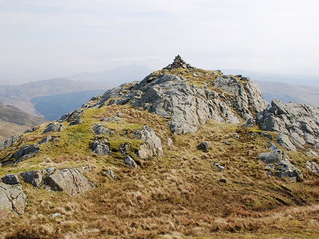
An Creachan is a prominent hill located in Argyllshire, Scotland. Standing at an elevation of 807 meters (2,648 feet), it is a popular destination for hikers and outdoor enthusiasts.

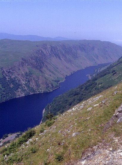
The hill is situated in the southern part of the Argyll Forest Park, near the banks of Loch Awe. It offers breathtaking panoramic views of the surrounding landscape, including the picturesque loch and the lush greenery of the park. On a clear day, visitors can even catch a glimpse of the distant mountains.

The ascent to the summit of An Creachan is relatively moderate, making it accessible to hikers of various levels of experience. The trail is well-marked and maintained, ensuring a safe and enjoyable journey for all. Along the way, hikers can expect to encounter diverse flora and fauna, including birch and oak trees, as well as a variety of bird species.

At the top of An Creachan, hikers are rewarded with magnificent vistas in all directions. The views stretch as far as the eye can see, encompassing the surrounding peaks, valleys, and lochs. It is a truly awe-inspiring sight that leaves visitors with a sense of tranquility and appreciation for the natural beauty of the Scottish Highlands.

Whether for a challenging hike or a peaceful walk in nature, An Creachan offers a memorable experience for anyone seeking to immerse themselves in the stunning landscapes of Argyllshire.

If you have any feedback on the listing, please let us know in the comments section below.

An Creachan Images

Images are sourced within 2km of 56.269782/-5.1484423 or Grid Reference NN0513. Thanks to Geograph Open Source API. All images are credited.

Eastern slopes of Cruach Mhòr
Forest, Salachry Extensive Forestry Commission plantations above Glen Aray.
Forest, Salachry
Extensive Forestry Commission plantations above Glen Aray.
A headwater of the Allt Blarghour A small burn, sometimes running under the peat, which is trying to drain the plateau between Loch Awe and Glen Aray. The water is destined for Loch Awe. A' Chruach, a rocky spur off Cruach Mhòr can be seen as a high point against the mist.
The moors here are still used for sheep farming. Plenty of deer too. The only birds encountered up here on a bleak day were a pair of stonechat and some red grouse.
A headwater of the Allt Blarghour
A small burn, sometimes running under the peat, which is trying to drain the plateau between Loch Awe and Glen Aray. The water is destined for Loch Awe. A' Chruach, a rocky spur off Cruach Mhòr can be seen as a high point against the mist. The moors here are still used for sheep farming. Plenty of deer too. The only birds encountered up here on a bleak day were a pair of stonechat and some red grouse.
A boggy watershed Blanket peat near Cruach Mhic Eoich. Between the point of view and the drier hills on the skyline runs the Alltan Airigh Mhic Choinnich, bound for Glen Aray and Loch Fyne. Behind me, any water that escapes the flat peatlands, will end up in the  Allt Blarghour, Loch Awe and eventually Loch Etive. The webbed feet, looking for something new to do could find the Argyll watershed an interesting challenge.
A boggy watershed
Blanket peat near Cruach Mhic Eoich. Between the point of view and the drier hills on the skyline runs the Alltan Airigh Mhic Choinnich, bound for Glen Aray and Loch Fyne. Behind me, any water that escapes the flat peatlands, will end up in the Allt Blarghour, Loch Awe and eventually Loch Etive. The webbed feet, looking for something new to do could find the Argyll watershed an interesting challenge.
Forest edge, Alltan Airigh Mhic Choinnich The edge of a large Forestry Commission block. The appalling Ordnance Survey cartography, AKA the purple plague*, shows that a lot of the moor here is also owned by the FC, but was mercifully left unplanted. Most of the square is an open sheep walk.

*I do hope that when you are reading this, the obtrusive purple is absent from the map. Its purpose according to the reply to a complaint about loss of contour data is to encourage map users not to go on to privately owned land.  What relevance this has to Scotland is a complete mystery. One thing is certain - there is NO access to the FC land to the southeast of here. It is choked in spiky trees with few gaps, let alone paths or clearings.
Forest edge, Alltan Airigh Mhic Choinnich
The edge of a large Forestry Commission block. The appalling Ordnance Survey cartography, AKA the purple plague*, shows that a lot of the moor here is also owned by the FC, but was mercifully left unplanted. Most of the square is an open sheep walk. *I do hope that when you are reading this, the obtrusive purple is absent from the map. Its purpose according to the reply to a complaint about loss of contour data is to encourage map users not to go on to privately owned land. What relevance this has to Scotland is a complete mystery. One thing is certain - there is NO access to the FC land to the southeast of here. It is choked in spiky trees with few gaps, let alone paths or clearings.
Forest edge below An Creachan Freedom of movement is somewhat curtailed here with a steep hillside on one side and a pathless young spruce plantation on the other. The ground is rocky, but was very easy to cross. I soon picked up a quad bike track which helped too.
The deer fence was now rotted and ruined, and there were red deer within the forest.
Forest edge below An Creachan
Freedom of movement is somewhat curtailed here with a steep hillside on one side and a pathless young spruce plantation on the other. The ground is rocky, but was very easy to cross. I soon picked up a quad bike track which helped too. The deer fence was now rotted and ruined, and there were red deer within the forest.
Forest edge below Creag Dubh Most of the square is a Sitka spruce plantation. This area near the edge, beyond the decaying deer fence is too marshy to plant and has been left open. It was also hard to cross on foot.
Forest edge below Creag Dubh
Most of the square is a Sitka spruce plantation. This area near the edge, beyond the decaying deer fence is too marshy to plant and has been left open. It was also hard to cross on foot.
Forest edge below Creag Dubh Following a quad bike track along the decaying fence which used to keep the deer out of a 1980's Forestry Commission plantation. Most of the square is still open, and is part of a sheep farm.
Forest edge below Creag Dubh
Following a quad bike track along the decaying fence which used to keep the deer out of a 1980's Forestry Commission plantation. Most of the square is still open, and is part of a sheep farm.
Forest above Kilmun (Glen Aray) Dusk above Glen Aray at the edge of a large 1980s planted Sitka plantation. The deer fence is decayed, and red deer can be seen inside the enclosure. A glimpse of Loch Fyne in the distance.
Forest above Kilmun (Glen Aray)
Dusk above Glen Aray at the edge of a large 1980s planted Sitka plantation. The deer fence is decayed, and red deer can be seen inside the enclosure. A glimpse of Loch Fyne in the distance.
Moorland A couple of miles of peat hags and heather separate the photographer from Cruach Mhor in the distance.
Moorland
A couple of miles of peat hags and heather separate the photographer from Cruach Mhor in the distance.
Peat bog A typical boggy depression on this area of moorland.
Peat bog
A typical boggy depression on this area of moorland.
Geograph sheep rescue This sheep was totally bogged at the hindquarters and would have been food for the ravens if I hadn't chanced upon it.
Geograph sheep rescue
This sheep was totally bogged at the hindquarters and would have been food for the ravens if I hadn't chanced upon it.
Unnamed lochan Cruach Bheag and Cruach Mhor in the background.
Unnamed lochan
Cruach Bheag and Cruach Mhor in the background.
Moorland pool Probably not even big enough to be a lochan, but a beautiful and serene spot on a day like today.
Moorland pool
Probably not even big enough to be a lochan, but a beautiful and serene spot on a day like today.
Cruach Bheag Cruach Bheag is the closer, and lower, summit. Cruach Mhor stands behind.
Cruach Bheag
Cruach Bheag is the closer, and lower, summit. Cruach Mhor stands behind.
Moorland burn At the foot of the slopes leading up to Cruach Mhor, very little peat has formed in this spot.
Moorland burn
At the foot of the slopes leading up to Cruach Mhor, very little peat has formed in this spot.
Red deer hinds Two of a group of five which were quietly grazing in a peat hole when I appeared over the horizon.
Red deer hinds
Two of a group of five which were quietly grazing in a peat hole when I appeared over the horizon.
Cruach Mhor Approaching the prominent peak of Cruach Mhor from the south-west.
Cruach Mhor
Approaching the prominent peak of Cruach Mhor from the south-west.
Show me another place!

An Creachan is located at Grid Ref: NN0513 (Lat: 56.269782, Lng: -5.1484423)

Unitary Authority: Argyll and Bute

Police Authority: Argyll and West Dunbartonshire

What 3 Words

///herring.baker.hired. Near Inveraray, Argyll & Bute

Nearby Locations

Creag Dhubh An Creachan

Related Wikis

Cruach Mhor (Argyll and Bute)

Cruach Mhor is a 589 metres (1,932 ft) mountain in Argyll and Bute in Scotland. == References ==

Beochlich

Beochlich (the Living Stone) is the name of a hydro electric project (taken from the burn of the same name) to the south-east of Loch Awe, and 9 km north...

Battle of Red Ford

The Battle of Red Ford or Battle of the String of Lorne was a battle in 1294 or else after September 1296 between Clan Campbell and Clan MacDougall in...

Inveraray Castle

Inveraray Castle (pronounced invə-REHRUH or invə-REHREH; Scottish Gaelic Caisteal Inbhir Aora [ˈkʰaʃtʲəl̪ˠ iɲɪɾʲˈɯːɾə]) is a country house near Inveraray...

Douglas Water, Loch Fyne

The Douglas Water (Scottish Gaelic: Dùghlas) is a river in Argyll in the southwest Scottish Highlands. It emerges from the northeastern end of the diminutive...

Loch Awe

Loch Awe (Scottish Gaelic: Loch Obha; also sometimes anglicised as Lochawe, Lochaw, or Lochow) is a large body of freshwater in Argyll and Bute, Scottish...

Inveraray Bell Tower

The Duke's Tower, also known as Inveraray Bell Tower, is the detached bell tower of All Saints' Church, Inveraray, Argyll and Bute, Scotland. Standing...

Inveraray

Inveraray ( or ; Scottish Gaelic: Inbhir Aora pronounced [iɲɪɾʲˈɯːɾə] meaning "mouth of the Aray") is a town in Argyll and Bute, Scotland. It is on the...

Have you been to An Creachan?

Leave your review of An Creachan below (or comments, questions and feedback).