Meall Each

Hill, Mountain in Ross-shire

Scotland

Meall Each

Slioch from the path by Loch an Sgeireach Taken while walking the Cape Wrath Trail.
Slioch from the path by Loch an Sgeireach Credit: Gary Dickson

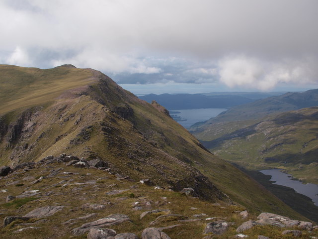
Meall Each is a prominent hill located in Ross-shire, in the Scottish Highlands. Rising to an elevation of approximately 806 meters (2,644 feet), it is classified as a Corbett, which is a term used to describe mountains in Scotland between 2,500 and 3,000 feet in height.

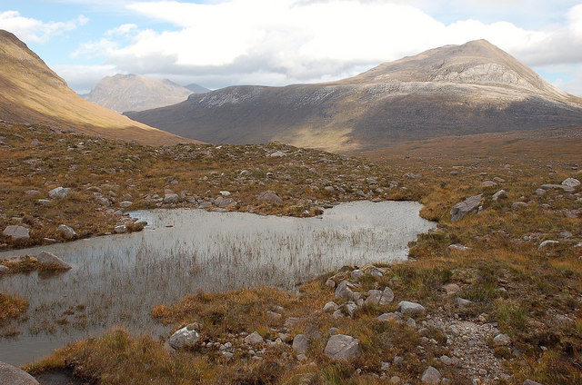
Situated in the northern part of Ross-shire, Meall Each offers breathtaking panoramic views of the surrounding countryside. Its position provides an excellent vantage point to observe the stunning landscapes of the Scottish Highlands, including the nearby mountain ranges and expansive glens.

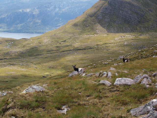
The hill is characterized by its rugged terrain, featuring steep slopes and rocky outcrops. However, there are also grassy areas that offer more accessible routes for hiking and climbing enthusiasts. The ascent to the summit can be challenging, but the rewarding views make it a popular destination for outdoor enthusiasts seeking a moderate to strenuous hiking experience.

Meall Each is also home to a diverse range of flora and fauna. The lower slopes are covered in heather, while higher altitudes feature hardy grasses and mosses. The hill provides a habitat for various bird species, including golden eagles, peregrine falcons, and ptarmigans.

Overall, Meall Each is a magnificent natural landmark in Ross-shire, offering visitors an opportunity to immerse themselves in the stunning beauty of the Scottish Highlands and experience the thrill of conquering a challenging yet rewarding mountain ascent.

If you have any feedback on the listing, please let us know in the comments section below.

Meall Each Images

Images are sourced within 2km of 57.652688/-5.317781 or Grid Reference NH0267. Thanks to Geograph Open Source API. All images are credited.

Slioch from the path by Loch an Sgeireach Taken while walking the Cape Wrath Trail.
Slioch from the path by Loch an Sgeireach
Taken while walking the Cape Wrath Trail.
Ruin at Smiorasair, on the NE side of Loch Maree The ruin at Smiorasair is in a small glen on the NE side of Loch Maree. It is on the footpath between Kinlochewe and Letterewe, situated below Slioch and adjacent to a waterfall. There are ruined walls and enclosures associated with the ruin.
Ruin at Smiorasair, on the NE side of Loch Maree
The ruin at Smiorasair is in a small glen on the NE side of Loch Maree. It is on the footpath between Kinlochewe and Letterewe, situated below Slioch and adjacent to a waterfall. There are ruined walls and enclosures associated with the ruin.
Ruin at Smiorasair, on the NE side of Loch Maree Ruin at Smiorasair, on the side of Loch Maree. The ruin is on the footpath between Kinlochewe and Letterewe. The ruin has associated low boundary walls and is near to the waterfall (at the top right of the image).
Ruin at Smiorasair, on the NE side of Loch Maree
Ruin at Smiorasair, on the side of Loch Maree. The ruin is on the footpath between Kinlochewe and Letterewe. The ruin has associated low boundary walls and is near to the waterfall (at the top right of the image).
Slioch from 80m above  Cromasaig An aerial shot taken from 80m above Cromasaig with DJI3 4k Drone. View north to Slioch with Kinlochewe village at base of mountains. Moine Thrust passes through Glen.
Slioch from 80m above Cromasaig
An aerial shot taken from 80m above Cromasaig with DJI3 4k Drone. View north to Slioch with Kinlochewe village at base of mountains. Moine Thrust passes through Glen.
Burn and dead tree below Sgurr Dubh Sgurr Dubh, seen behind at right, is part of the Slioch massif.
Burn and dead tree below Sgurr Dubh
Sgurr Dubh, seen behind at right, is part of the Slioch massif.
Col between Sgurr Dubh and Meall Each The majority of walkers climbing Slioch will gain this col before going round below Sgurr Dubh - behind the photographer - into the Coire na Sleaghaich. The picture looks roughly east across the col, with peaks of the Fannichs range in the distance.
Col between Sgurr Dubh and Meall Each
The majority of walkers climbing Slioch will gain this col before going round below Sgurr Dubh - behind the photographer - into the Coire na Sleaghaich. The picture looks roughly east across the col, with peaks of the Fannichs range in the distance.
Looking down Coire na Sleaghaich Most ascents of Slioch will pass through this corrie. The highest parts of the mountain lie behind the photographer and the picture looks down the Coire na Sleaghaich, past the shoulder of Sgurr Dubh, towards the summit of Beinn a Mhuinidh beyond.
Looking down Coire na Sleaghaich
Most ascents of Slioch will pass through this corrie. The highest parts of the mountain lie behind the photographer and the picture looks down the Coire na Sleaghaich, past the shoulder of Sgurr Dubh, towards the summit of Beinn a Mhuinidh beyond.
Ridge between Slioch and Sgurr an Tuill Bhain From the summit of Sgurr an Tuill Bhain, the picture looks roughly west along the ridge that joins this summit to the north, highest top of Slioch. This ridge becomes quite well-defined in the middle, as seen in <a href="https://www.geograph.org.uk/photo/1684107">NH0168 : "Wait for me, mum..."</a>. Loch Maree lies beyond.
Ridge between Slioch and Sgurr an Tuill Bhain
From the summit of Sgurr an Tuill Bhain, the picture looks roughly west along the ridge that joins this summit to the north, highest top of Slioch. This ridge becomes quite well-defined in the middle, as seen in NH0168 : "Wait for me, mum...". Loch Maree lies beyond.
Looking across Coire na Sleaghaich The picture looks south from the summit of Sgurr an Tuill Bhain across Slioch's big corrie, the Coire na Sleaghaich. Slioch's trig point and actual summit are just off the right of the picture.
Looking across Coire na Sleaghaich
The picture looks south from the summit of Sgurr an Tuill Bhain across Slioch's big corrie, the Coire na Sleaghaich. Slioch's trig point and actual summit are just off the right of the picture.
Feral goats above Coire na Sleaghaich I came across these goats on the lower slopes of Sgurr an Tuill Bhain, east and south of the summit. They seem to be commonplace around Loch Maree and were actually the second party I met on a day traversing Slioch. The left-hand one has lost a horn.
Feral goats above Coire na Sleaghaich
I came across these goats on the lower slopes of Sgurr an Tuill Bhain, east and south of the summit. They seem to be commonplace around Loch Maree and were actually the second party I met on a day traversing Slioch. The left-hand one has lost a horn.
Rowan and old wall The remnants of an old wall can be seen heading downhill away from the rowan. Rowans are often found growing by ruined dwelling places - I believe they were thought to ward off malign influences. Cliffs of Beinn a' Mhuinidh are seen behind, across Gleann Bianasdail.
Rowan and old wall
The remnants of an old wall can be seen heading downhill away from the rowan. Rowans are often found growing by ruined dwelling places - I believe they were thought to ward off malign influences. Cliffs of Beinn a' Mhuinidh are seen behind, across Gleann Bianasdail.
Beinn a' Mhùinidh from Loch Maree Bonaid Dhonn, the imposing prow of the mountain, seen from the shore of the loch.
Beinn a' Mhùinidh from Loch Maree
Bonaid Dhonn, the imposing prow of the mountain, seen from the shore of the loch.
Stone circle, Slioch
The Bonaid Dhonn The abrupt precipitous nose of Beinn a' Mhùinidh, seen from across Loch Maree. The name means Brown Bonnet in English.
The Bonaid Dhonn
The abrupt precipitous nose of Beinn a' Mhùinidh, seen from across Loch Maree. The name means Brown Bonnet in English.
Rocks and knolls near summit of Beinn a' Mhùinidh Rockiness just north of the summit of Beinn a' Mhùinidh.
Slioch is the Munro occupying the centre section of the image; to the right of it and further away are the two remote Munros, A' Mhaighdean and Ruadh Stac Mòr.
Rocks and knolls near summit of Beinn a' Mhùinidh
Rockiness just north of the summit of Beinn a' Mhùinidh. Slioch is the Munro occupying the centre section of the image; to the right of it and further away are the two remote Munros, A' Mhaighdean and Ruadh Stac Mòr.
Abhainn an Fhasaigh and Loch Maree The Abhainn an Fhasaigh about to descend from its course through Gleann Bianasdail towards Loch Maree.
Abhainn an Fhasaigh and Loch Maree
The Abhainn an Fhasaigh about to descend from its course through Gleann Bianasdail towards Loch Maree.
The foot of Gleann Bianasdail With falls on the Abhainn an Fhasaigh visible, and the ramparts of Beinn a' Mhùinidh towering above.
The foot of Gleann Bianasdail
With falls on the Abhainn an Fhasaigh visible, and the ramparts of Beinn a' Mhùinidh towering above.
The Abhainn an Fhasaigh above the footbridge Dropping into a miniature ravine. Sgùrr Dubh of Slioch is the mountain in the background.
The Abhainn an Fhasaigh above the footbridge
Dropping into a miniature ravine. Sgùrr Dubh of Slioch is the mountain in the background.
Show me another place!

Meall Each is located at Grid Ref: NH0267 (Lat: 57.652688, Lng: -5.317781)

Unitary Authority: Highland

Police Authority: Highlands and Islands

What 3 Words

///washable.rebirth.sparkles. Near Kinlochewe, Highland

Related Wikis

Slioch

Slioch (Scottish Gaelic: Sleaghach) is a mountain in the Scottish Highlands situated in Wester Ross, eight kilometres north of the village of Kinlochewe...

Taagan

Taagan (Scottish Gaelic: Na Tathagan) is a hamlet in Ross and Cromarty, in the Highland council area of Scotland. It is situated about 2 km north west...

Lochan Fada, Letterewe

Lochan Fada (The long long) is a large remote and deep freshwater loch that is located three miles north-east of Loch Maree in Wester Ross in the Northwest...

Anancaun

Anancaun (Scottish Gaelic: Àth nan Ceann) is a small hamlet located in Ross-shire, Scotland, within the Scottish council area of Highland. == References ==

Cape Wrath Trail

Cape Wrath Trail is a hiking route that runs through the Scottish Highlands and along the west coast of Scotland. It is approximately 200 miles (321 km...

Kinlochewe

Kinlochewe (Scottish Gaelic: Ceann Loch Iù or Iùbh) is a village in Wester Ross in the Northwest Highlands of Scotland. It is in the parish of Gairloch...

Beinn Tarsuinn (Munro)

Beinn Tarsuinn (934 m) is a mountain in the Northwest Highlands of Wester Ross, Scotland. It lies in the heart of the remote Dundonnell and Fisherfield...

Meall a' Ghiubhais

Meall a' Ghiubhais (887 m) is a mountain in the Northwest Highlands, Scotland. It lies in Wester Ross, close to the village of Kinlochewe. The mountain...

Have you been to Meall Each?

Leave your review of Meall Each below (or comments, questions and feedback).