Cnoc Loch Bad an Sgalaig

Hill, Mountain in Ross-shire

Scotland

Cnoc Loch Bad an Sgalaig

Dubh Loch from the summit of Mullach nan Cadhaichean In the background are the hills of the Letterewe Forest.
Dubh Loch from the summit of Mullach nan Cadhaichean Credit: Michael Earnshaw

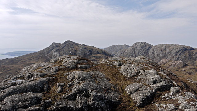
Cnoc Loch Bad an Sgalaig is a prominent hill located in Ross-shire, in the Highlands of Scotland. It stands at an elevation of approximately 678 meters (2,224 feet) above sea level and is known for its stunning landscape and panoramic views.

The hill is part of the larger mountain range known as the Scottish Highlands, which is renowned for its rugged beauty and diverse ecosystems. Cnoc Loch Bad an Sgalaig is situated near the village of Aultbea and is surrounded by vast moorlands, lochs, and dense forests, creating a picturesque setting.

The ascent to the summit of Cnoc Loch Bad an Sgalaig is challenging but rewarding, offering hikers and mountaineers the opportunity to experience the breathtaking scenery of the region. From the top, visitors can enjoy sweeping views of the surrounding mountains, glens, and shimmering lochs, such as Loch Bad an Sgalaig itself.

The hill is also home to a wide variety of wildlife, including red deer, mountain hares, and golden eagles, making it a popular destination for nature enthusiasts and wildlife photographers. The diverse flora and fauna found in the area further contribute to its ecological significance.

Cnoc Loch Bad an Sgalaig is a destination that offers outdoor enthusiasts a chance to immerse themselves in the beauty of the Scottish Highlands, with its rugged terrain, stunning vistas, and abundant wildlife. Whether it's hiking, photography, or simply enjoying the tranquility of the surroundings, this hill provides a memorable experience for all who visit.

If you have any feedback on the listing, please let us know in the comments section below.

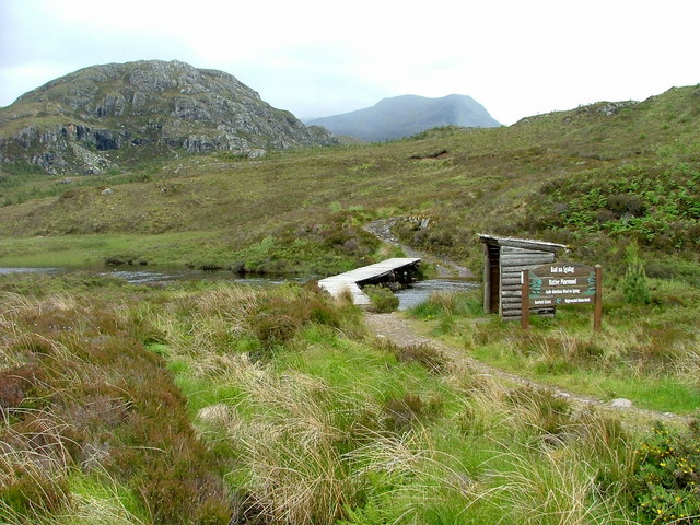
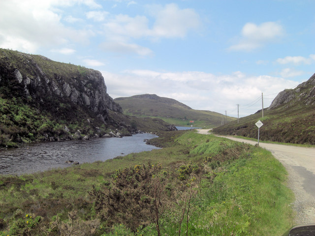
Cnoc Loch Bad an Sgalaig Images

Images are sourced within 2km of 57.679886/-5.6176805 or Grid Reference NG8471. Thanks to Geograph Open Source API. All images are credited.

Dubh Loch from the summit of Mullach nan Cadhaichean In the background are the hills of the Letterewe Forest.
Dubh Loch from the summit of Mullach nan Cadhaichean
In the background are the hills of the Letterewe Forest.
Dubh Loch
Dubh Loch
Sandstone outcrop above Dubh Loch One of a number of these outcrops in mostly grassy moorland with fairly recent native woodland planting.
Sandstone outcrop above Dubh Loch
One of a number of these outcrops in mostly grassy moorland with fairly recent native woodland planting.
Native woodland planting above Dubh Loch Part of a large scale native tree planting to try and regenerate native woodland.  The seeds for the trees were collected on Loch Maree islands and Beinn Eighe nature reserve.
Native woodland planting above Dubh Loch
Part of a large scale native tree planting to try and regenerate native woodland. The seeds for the trees were collected on Loch Maree islands and Beinn Eighe nature reserve.
Inlet on Dubh Loch
Inlet on Dubh Loch
Allt a' Gharbh Choire The river runs into Dubh Loch.
Allt a' Gharbh Choire
The river runs into Dubh Loch.
Heading for Am Feur-Loch On the track from Loch na h-Oidhche, as it heads downhill before levelling out by the loch. Taken before the regeneration project for this spot was started.
Heading for Am Feur-Loch
On the track from Loch na h-Oidhche, as it heads downhill before levelling out by the loch. Taken before the regeneration project for this spot was started.
Lone derelict cottage Taken from a layby on the A832.
Looking across Loch Bad an Sgalaig.
Lone derelict cottage
Taken from a layby on the A832. Looking across Loch Bad an Sgalaig.
Road beside Loch Bad an Sgalaig The A832 which has passing places on this stretch.
Road beside Loch Bad an Sgalaig
The A832 which has passing places on this stretch.
Loch Bad an Sgalaig Dam This loch was dammed in 1949 to power the Kerry Falls power station.
Loch Bad an Sgalaig Dam
This loch was dammed in 1949 to power the Kerry Falls power station.
Footbridge and path to Bad na Sgalag native pinewood The water is the outflow from Am Feur-Loch.
Footbridge and path to Bad na Sgalag native pinewood
The water is the outflow from Am Feur-Loch.
Am Feur-Loch
Am Feur-Loch
Outflow from Am Feur-Loch The water in the far distance is Loch Bad an Sgalaig.
Outflow from Am Feur-Loch
The water in the far distance is Loch Bad an Sgalaig.
A832 runs beside Am Feur-Loch Feur-Loch is grassy loch?
A832 runs beside Am Feur-Loch
Feur-Loch is grassy loch?
Dam across Loch Bad an Sgalaig outfall The loch of the clump of the farm worker is the rather convoluted name of this body of water. The outflow becomes the River Kerry but damming the loch has inundated much of the original waterfall and made it one with Dubh Loch to the south.
Dam across Loch Bad an Sgalaig outfall
The loch of the clump of the farm worker is the rather convoluted name of this body of water. The outflow becomes the River Kerry but damming the loch has inundated much of the original waterfall and made it one with Dubh Loch to the south.
Loch Bad an Sgalaig Near Gairloch, a derelict lochside cottage.
Loch Bad an Sgalaig
Near Gairloch, a derelict lochside cottage.
Loch Bad an Sgalaig Looking across the loch. There are marked footpaths leading into the hills.
Loch Bad an Sgalaig
Looking across the loch. There are marked footpaths leading into the hills.
Meall Aundrary Meall Aundrary is a prominent if low hill to the north of the A832 near to Loch Bad an Sgalaig; it has two tops of a similar height, the image being recorded from the higher of them. The hills beyond are Sithean Mor and An Groban the rocky nature of which is typical of the low hills between Loch Gairloch and the head of Loch Maree.
Meall Aundrary
Meall Aundrary is a prominent if low hill to the north of the A832 near to Loch Bad an Sgalaig; it has two tops of a similar height, the image being recorded from the higher of them. The hills beyond are Sithean Mor and An Groban the rocky nature of which is typical of the low hills between Loch Gairloch and the head of Loch Maree.
Show me another place!

Cnoc Loch Bad an Sgalaig is located at Grid Ref: NG8471 (Lat: 57.679886, Lng: -5.6176805)

Unitary Authority: Highland

Police Authority: Highlands and Islands

What 3 Words

///beaters.panicking.shoebox. Near Gairloch, Highland

Nearby Locations

Cnoc Loch Bad an Sgalaig

Related Wikis

Kerry Falls Hydro-Electric Scheme

Kerry Falls Hydro-Electric Scheme, sometimes known as Gairloch is a small-scale hydro-electric power station, built by the North of Scotland Hydro-Electric...

Fairy Lochs

The Fairy Lochs is a recent English name for Na Lochan Sgeireach and are a small group of freshwater lochans approximately 2 mi (3.2 km) south-east of...

Loch Bràigh Horrisdale

Loch Bràigh Horrisdale is a small, irregular shaped, freshwater loch in Wester Ross, in the north west of Scotland. The loch lies approximately 2 mi (3...

Charlestown, Wester Ross

Charlestown is a small hamlet, making up one of the settlements which are collectively called Gairloch, and located directly south of the main village...

Have you been to Cnoc Loch Bad an Sgalaig?

Leave your review of Cnoc Loch Bad an Sgalaig below (or comments, questions and feedback).