Cnoc Loch Losguinn

Hill, Mountain in Argyllshire

Scotland

Cnoc Loch Losguinn

Towards ruin below Cruach Eoghainn
Towards ruin below Cruach Eoghainn Credit: Chris Wimbush

Cnoc Loch Losguinn is a prominent hill located in Argyllshire, Scotland. Situated in the western part of the country, it forms part of the breathtaking landscape of the Scottish Highlands. With an elevation of approximately 625 meters (2,050 feet), it stands as a notable landmark in the region.

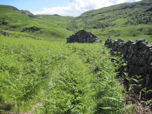
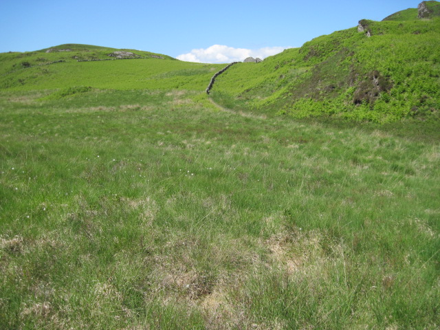
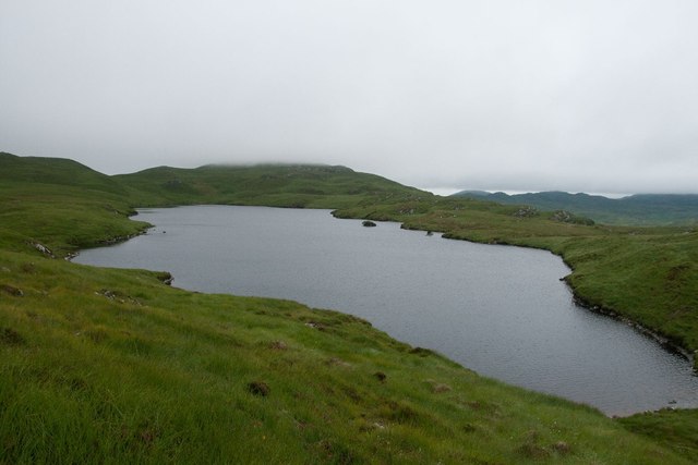
The hill is characterized by its distinct shape, featuring a gently sloping ascent leading to a rounded summit. The surrounding terrain is predominantly rough and rugged, offering a challenging yet rewarding climb for outdoor enthusiasts. Cnoc Loch Losguinn provides stunning panoramic views of the surrounding countryside, including picturesque lochs, rolling hills, and distant mountain ranges.

The area surrounding the hill is rich in natural beauty and offers ample opportunities for outdoor activities such as hiking, wildlife observation, and photography. The hill is home to a variety of flora and fauna, including heather, mosses, and various bird species.

Access to Cnoc Loch Losguinn is relatively straightforward, with a well-defined footpath leading to the summit. However, it is essential for visitors to be well-prepared and equipped with appropriate hiking gear, as the weather conditions in the Scottish Highlands can be unpredictable and change rapidly.

Cnoc Loch Losguinn is not only a popular destination for outdoor enthusiasts but also serves as a valuable site for scientific research and conservation efforts. Its unique geological formations and diverse ecosystems make it an important area of interest for geologists, ecologists, and nature enthusiasts alike.

If you have any feedback on the listing, please let us know in the comments section below.

Cnoc Loch Losguinn Images

Images are sourced within 2km of 56.115121/-5.7125002 or Grid Reference NR6997. Thanks to Geograph Open Source API. All images are credited.

Towards ruin below Cruach Eoghainn
Gleann nam Muc towards ruin
Burn below Beinn Bhiorgaig towards Glentrosdale River
Glen Trosdale with Cruach na Seilcheig above Taken from deck of PS Waverley in Gulf of Corryvreckan.

Glen Trosdale is the very obvious gash in the hillside
Glen Trosdale with Cruach na Seilcheig above
Taken from deck of PS Waverley in Gulf of Corryvreckan. Glen Trosdale is the very obvious gash in the hillside
Grassy moorland rising to Cruach na Seilcheig Cruach na Seilcheig is a minor summit of northern Jura; it's seen here from the south, beside a stream, where the name Glaca Mine appears on larger scale maps but does not seem to refer to the watercourse itself.
Grassy moorland rising to Cruach na Seilcheig
Cruach na Seilcheig is a minor summit of northern Jura; it's seen here from the south, beside a stream, where the name Glaca Mine appears on larger scale maps but does not seem to refer to the watercourse itself.
Moorland with rock outcrops north from Cruach na Seilcheig The northern end of the Isle of Jura is a mass of low hills with rock outcrops set among moorland. The view here is to the north from the highest point among those hills out over the Gulf of Corryvreckan to the island of Scarba.
Moorland with rock outcrops north from Cruach na Seilcheig
The northern end of the Isle of Jura is a mass of low hills with rock outcrops set among moorland. The view here is to the north from the highest point among those hills out over the Gulf of Corryvreckan to the island of Scarba.
Moorland north of Cruach na Seilcheig Cruach na Seilcheig is the highest of the low hills occupying the northern end of Jura. The view here is not from the summit of the hill but a rise to the south-east a few metres lower where there's a trig point. The island of Scarba off the north coast of Jura is seen beyond the Gulf of Corryvreckan.
Moorland north of Cruach na Seilcheig
Cruach na Seilcheig is the highest of the low hills occupying the northern end of Jura. The view here is not from the summit of the hill but a rise to the south-east a few metres lower where there's a trig point. The island of Scarba off the north coast of Jura is seen beyond the Gulf of Corryvreckan.
Moorland north of Cnoc Loch Losguinn Cnoc Loch Losguinn is a minor hill feature of the remote moorland at the north end of Jura. The view is to islands further north with Mull far distant, Scarba the large feature at the right side of the image and the small, low isle of Eileach an Naoimh beyond the turmoil of disturbed water that is the Corryvreckan.
Moorland north of Cnoc Loch Losguinn
Cnoc Loch Losguinn is a minor hill feature of the remote moorland at the north end of Jura. The view is to islands further north with Mull far distant, Scarba the large feature at the right side of the image and the small, low isle of Eileach an Naoimh beyond the turmoil of disturbed water that is the Corryvreckan.
Allt Garbh
Allt Garbh
Allt Garbh
Allt Garbh
Glentrosdale River
Glentrosdale River
Beul Leathad towards Allt Garbh
Loch Losguinn from Beul Leathad
Towards Glentrosdale
Loch na Conaire, Jura A pair of Red-throated Divers were breeding on this loch.
Loch na Conaire, Jura
A pair of Red-throated Divers were breeding on this loch.
Allt Garbh, Jura
Allt Garbh, Jura
Allt Garbh, Jura
Allt Garbh, Jura
Bridge across Allt Garbh, Jura
Show me another place!

Cnoc Loch Losguinn is located at Grid Ref: NR6997 (Lat: 56.115121, Lng: -5.7125002)

Unitary Authority: Argyll and Bute

Police Authority: Argyll and West Dunbartonshire

What 3 Words

///adjuster.accusing.battle. Near Lochgilphead, Argyll & Bute

Related Wikis

Barnhill, Jura

Barnhill is a farmhouse in the north of the island of Jura in the Scottish Inner Hebrides overlooking the Sound of Jura. It stands on the site of a larger...

Kinuachdrachd

Kinuachdrachd or Kinuachdrach is a place about 22 miles from Craighouse on the island of Jura, in the council area of Argyll and Bute, Scotland. It comprises...

Jura, Scotland

Jura ( JOOR-ə; Scottish Gaelic: Diùra) is an island in the Inner Hebrides of Scotland, adjacent to and northeast of Islay. With an area of 36,692 hectares...

Gulf of Corryvreckan

The Gulf of Corryvreckan (from the Gaelic Coire Bhreacain, meaning 'cauldron of the speckled seas' or 'cauldron of the plaid'), also called the Strait...

Nearby Amenities

Located within 500m of 56.115121,-5.7125002
Beul Leathad
Ele: 235
Natural: peak
Source: OS_OpenData_StreetView
Source Ele: Scotisch Popular Historic
Lat/Long: 56.1106766/-5.713149
Cnoc Loch Losguinn
Ele: 235
Natural: peak
Source: OS_OpenData_StreetView
Source Ele: Scotisch Popular Historic
Lat/Long: 56.1151502/-5.7127246
Gleann Dorch
Place: locality
Source: OS_OpenData_StreetView
Lat/Long: 56.1125609/-5.7178424
The data included in this document is from www.openstreetmap.org. The data is made available under ODbL.

Have you been to Cnoc Loch Losguinn?

Leave your review of Cnoc Loch Losguinn below (or comments, questions and feedback).