Corra-bheinn

Hill, Mountain in Argyllshire

Scotland

Corra-bheinn

Glen More On the A849
Glen More Credit: Andrew Abbott

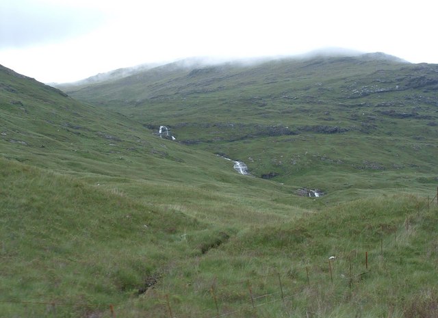
Corra-bheinn is a prominent hill located in the scenic region of Argyllshire in western Scotland. Rising to an elevation of 704 meters (2,310 feet), it is classified as a Corbett, a term used to denote Scottish hills between 2,500 and 3,000 feet.

Situated near the village of Lochgilphead, Corra-bheinn boasts breathtaking vistas of the surrounding landscape. Its position on the Cowal Peninsula provides visitors with panoramic views of Loch Fyne, one of Scotland's largest and most picturesque sea lochs. On clear days, the summit of Corra-bheinn offers a remarkable vantage point to observe the neighboring islands of Islay, Jura, and Gigha.

The ascent to Corra-bheinn is a challenging but rewarding experience for hillwalkers and hikers. The route follows a path that winds through moorland, heather, and rocky terrain, offering a diverse range of landscapes to explore. Visitors may encounter various species of wildlife, including red deer, golden eagles, and peregrine falcons, adding to the allure of the climb.

Corra-bheinn's location within the Argyll Forest Park, a designated area of outstanding natural beauty, ensures that the hill remains relatively unspoiled and provides a tranquil setting for outdoor enthusiasts. The surrounding parkland features ancient woodlands, cascading waterfalls, and serene lochs, making it an ideal destination for nature lovers.

Whether you seek a challenging hike or simply wish to immerse yourself in the tranquility of the Scottish countryside, Corra-bheinn in Argyllshire offers a captivating experience that showcases the beauty of this picturesque region.

If you have any feedback on the listing, please let us know in the comments section below.

Corra-bheinn Images

Images are sourced within 2km of 56.419318/-5.936363 or Grid Reference NM5732. Thanks to Geograph Open Source API. All images are credited.

Glen More On the A849
Glen More
On the A849
A849 in Glen More Heading east.
A849 in Glen More
Heading east.
Old bridge on the A849 in Glen More
A849 looking towards Ben More
Old road bridge in Glen More At Teanga Brideig
Old road bridge in Glen More
At Teanga Brideig
Old road bridge at Teanga Brìdeig
Old road bridge over Allt Ghillecaluim
Heading down the road to Fionnphort Dramatic mountains all around, the highest in Mull. Ben More (966m) to the left, A'Chioch (867m) under a little cloud and Beinn Fhada (702m) on the right
Heading down the road to Fionnphort
Dramatic mountains all around, the highest in Mull. Ben More (966m) to the left, A'Chioch (867m) under a little cloud and Beinn Fhada (702m) on the right
Allt Ghilecaluim Needs a bit more rain to make the waterfall more impressive.
Allt Ghilecaluim
Needs a bit more rain to make the waterfall more impressive.
Bridge on the Gearr Abhainn The bridge that carried the old Glen More road - now redundant.
Bridge on the Gearr Abhainn
The bridge that carried the old Glen More road - now redundant.
Allt Ghillecaluim Bridge over the Allt Ghillecaluim in Glen More. The road has been rebuilt, but still as a single track road.
Allt Ghillecaluim
Bridge over the Allt Ghillecaluim in Glen More. The road has been rebuilt, but still as a single track road.
Allt Ghillecaluim and Beinn a' Mheadhoin Burn running through steep grassland, basic rocks provide good growing conditions on much of Mull.  Beinn a'Mheadhoin on the right.
Allt Ghillecaluim and Beinn a' Mheadhoin
Burn running through steep grassland, basic rocks provide good growing conditions on much of Mull. Beinn a'Mheadhoin on the right.
Mountain stream The stream is about to go down the last steep drop before arriving at the flat ground where Glen More widens and flattens as it reaches the sea (which can just be seen to the right hand side).
Mountain stream
The stream is about to go down the last steep drop before arriving at the flat ground where Glen More widens and flattens as it reaches the sea (which can just be seen to the right hand side).
Golden Hillside A mid-winter's view of the hillside of Guibean Uluvailt lit up by the low sun.
Golden Hillside
A mid-winter's view of the hillside of Guibean Uluvailt lit up by the low sun.
Coir' an t-Sailein This is the coire on the western side of Cruachan Dearg (704m), of which the snow topped summit can just be seen.
Coir' an t-Sailein
This is the coire on the western side of Cruachan Dearg (704m), of which the snow topped summit can just be seen.
Winter sun at head of Sleibhte-Coire Nearing the high point on the right of way to Loch na Keil. The path is a bit  of a quagmire at this time of year (perhaps it always is). The sharp summit of A' Choich can be seen to the left and Beinn Fhada to the right.
Winter sun at head of Sleibhte-Coire
Nearing the high point on the right of way to Loch na Keil. The path is a bit of a quagmire at this time of year (perhaps it always is). The sharp summit of A' Choich can be seen to the left and Beinn Fhada to the right.
Summit of Cruachan Dearg The view from the summit of the "Graham" (well, actually half a Graham as it is a twin with its neighbour Corra-Bheinn as both are the same height - 704m -  and there is only about an 80m drop between them). The nearest water is Loch Ba and beyond that you can see the sea (the Sound of Mull), then Ardnamurchan and in the distance (top left just below the clouds) can be seen the Isle of Rum.
Summit of Cruachan Dearg
The view from the summit of the "Graham" (well, actually half a Graham as it is a twin with its neighbour Corra-Bheinn as both are the same height - 704m - and there is only about an 80m drop between them). The nearest water is Loch Ba and beyond that you can see the sea (the Sound of Mull), then Ardnamurchan and in the distance (top left just below the clouds) can be seen the Isle of Rum.
Grassy col The grassy col to the right is between Corra-bheinn and Beinn a'Mheadhoin. New plantation can be seen in the distance in Liath Dhoire.
Grassy col
The grassy col to the right is between Corra-bheinn and Beinn a'Mheadhoin. New plantation can be seen in the distance in Liath Dhoire.
Show me another place!

Corra-bheinn is located at Grid Ref: NM5732 (Lat: 56.419318, Lng: -5.936363)

Unitary Authority: Argyll and Bute

Police Authority: Argyll and West Dunbartonshire

What 3 Words

///highly.outcasts.renews. Near Lochbuie, Argyll & Bute

Nearby Locations

Corra-bheinn

Related Wikis

Ben More (Mull)

Ben More (Scottish Gaelic: Beinn Mhòr, meaning "great mountain") is the highest mountain and only Munro (mountains in Scotland that reach an elevation...

Isle of Mull

The Isle of Mull (Scottish Gaelic: An t-Eilean Muileach [əɲ ˈtʲʰelan ˈmuləx]) or just Mull (Scots pronunciation: [mʌl]; Scottish Gaelic: Muile [ˈmulə]...

Loch Bà (Mull)

Loch Bà is a freshwater loch, about 5 km long, in the centre of the Isle of Mull, in Scotland. It is drained by the River Bà, flowing into Loch na Keal...

Beinn Talaidh

Beinn Talaidh (762 m) is a peak on the Isle of Mull, Scotland, located in the mountainous centre of the Island. The mountain is shaped like a symmetrical...

Aird of Kinloch

Aird of Kinloch (Gaelic:An Àird) is a rocky outcrop between Loch Scridain and Loch Beg on the Isle of Mull, Argyll and Bute, Scotland. == References ==

Ben Buie

Ben Buie (717 m) is a mountain in the south of the Isle of Mull, Scotland. A rocky mountain, it has steep and rugged slopes, especially on its eastern...

Pennyghael

Pennyghael (Scottish Gaelic: Peighinn nan Gàidheal) is a small village in the Ross of Mull, Argyll and Bute, Scotland. It is located along the A849 road...

Creach-Beinn (Mull)

Creach-Beinn (698 m) is a mountain in the south of the Isle of Mull, Scotland. It rises above the northern shore of Loch Spelve. A rocky mountain with...

Nearby Amenities

Located within 500m of 56.419318,-5.936363
Corra-bheinn
Corbett: no
Ele: 704
Graham: yes
Marilyn: yes
Munro: no
Natural: peak
Prominence: 316
Source: NPE
Wikidata: Q20594568
Lat/Long: 56.419647/-5.9357075
The data included in this document is from www.openstreetmap.org. The data is made available under ODbL.

Have you been to Corra-bheinn?

Leave your review of Corra-bheinn below (or comments, questions and feedback).