Ballimore

Settlement in Argyllshire

Scotland

Ballimore

Shore at Otter Ferry On the east side of Loch Fyne.
Shore at Otter Ferry Credit: Alan Reid

Ballimore is a small village located on the western coast of Scotland, in the historic county of Argyllshire. Situated in the picturesque region of Argyll and Bute, it is nestled between the stunning Loch Sween to the north and the rolling hills of Knapdale to the south. The village is a hidden gem, offering a peaceful and idyllic setting for residents and visitors alike.

With a population of around 150, Ballimore retains a close-knit community feel. The village features a charming collection of traditional stone houses, many of which date back several centuries. The surrounding landscape is dominated by lush green fields and woodlands, providing a rich tapestry of natural beauty.

Ballimore benefits from its proximity to Loch Sween, which offers a range of recreational activities such as fishing, sailing, and kayaking. The loch is also home to a diverse array of wildlife, including seals, otters, and numerous bird species, making it a haven for nature enthusiasts.

Although small, Ballimore boasts a few essential amenities, including a local pub and a village shop. For more extensive services and facilities, residents can easily access nearby towns such as Lochgilphead, which is approximately 10 miles away.

Overall, Ballimore is an enchanting and tranquil village that offers a peaceful escape from the hustle and bustle of modern life. Its natural beauty and strong sense of community make it a delightful place to live or visit for those seeking a slower pace of life amidst the stunning Scottish countryside.

If you have any feedback on the listing, please let us know in the comments section below.
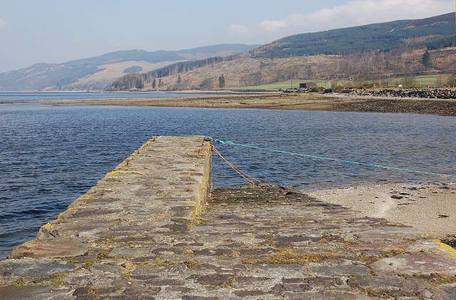
Ballimore Images

Images are sourced within 2km of 55.994722/-5.3367847 or Grid Reference NR9283. Thanks to Geograph Open Source API. All images are credited.

Shore at Otter Ferry On the east side of Loch Fyne.
Shore at Otter Ferry
On the east side of Loch Fyne.
Quay on Loch Fyne at Otter Ferry
The Shore of Loch Fyne At Otter Ferry.
The Shore of Loch Fyne
At Otter Ferry.
Evening Light Over Loch Fyne
The Shore of Loch Fyne At Otter Ferry it was neither shingle nor sand, but thousands of small shells.
The Shore of Loch Fyne
At Otter Ferry it was neither shingle nor sand, but thousands of small shells.
The shore road to Ballimore
Ballimore, Otter Ferry
Rubha an Eheurain
Rubha an Eheurain
A touch of spring by Loch Fyne
Old Milestone by the B8000, Otter Ferry, Loch Fyne Stone post by the B8000, in parish of Kilfinan (Cowal District), Otter Ferry, South end of village, by wall.

Inscription reads:-
TO
DUNOON
22

Surveyed

Milestone Society National ID: AB_DNOF22
Old Milestone by the B8000, Otter Ferry, Loch Fyne
Stone post by the B8000, in parish of Kilfinan (Cowal District), Otter Ferry, South end of village, by wall. Inscription reads:- TO DUNOON 22 Surveyed Milestone Society National ID: AB_DNOF22
Old Milepost by the B8000, north of Auchnaha, Kilfinan parish Dunoon plate by the B8000, in parish of Kilfinan (Argyll and Bute District), North of Auchnaha, roadside against wall.

Inscription reads:-
{<-hand}
TIGHNABRUAICH
11 MILES
{diamond}

Surveyed

Milestone Society National ID: AB_TGOF11
Old Milepost by the B8000, north of Auchnaha, Kilfinan parish
Dunoon plate by the B8000, in parish of Kilfinan (Argyll and Bute District), North of Auchnaha, roadside against wall. Inscription reads:- {<-hand} TIGHNABRUAICH 11 MILES {diamond} Surveyed Milestone Society National ID: AB_TGOF11
Loch Fyne beyond old pier at Otter Ferry Since this image was recorded, (05/10/2000), a new pier has been built adjacent to this, out of view to the left of the view. Gordon Brown&amp;#039;s image shows both old and new - &lt;a title=&quot;https://www.geograph.org.uk/photo/2152142&quot; href=&quot;https://www.geograph.org.uk/photo/2152142&quot;&gt;Link&lt;/a&gt;.
(From a copied, Fujichrome transparency.)
Loch Fyne beyond old pier at Otter Ferry
Since this image was recorded, (05/10/2000), a new pier has been built adjacent to this, out of view to the left of the view. Gordon Brown's image shows both old and new - Link. (From a copied, Fujichrome transparency.)
The remains of Loch Fyne anti-submarine boom The boom would have protected the upper reaches of Loch Fyne, a sea loch with considerable inland reach.  It has been postulated that this was the remains of an engine room, or more likely, a store for the site.  It has been largely destroyed by demolition or the placement of large boulders for sea-defence on top of it.  The Canmore entry &lt;span class=&quot;nowrap&quot;&gt;&lt;a title=&quot;https://canmore.org.uk/site/205007/otter-ferry-loch-fyne-anti-submarine-boom&quot; rel=&quot;nofollow ugc noopener&quot; href=&quot;https://canmore.org.uk/site/205007/otter-ferry-loch-fyne-anti-submarine-boom&quot;&gt;Link&lt;/a&gt;&lt;img style=&quot;margin-left:2px;&quot; alt=&quot;External link&quot; title=&quot;External link - shift click to open in new window&quot; src=&quot;https://s1.geograph.org.uk/img/external.png&quot; width=&quot;10&quot; height=&quot;10&quot;/&gt;&lt;/span&gt; has photographs of the structure in April 2013.  Further information can be noted in the Secret Scotland entry at &lt;span class=&quot;nowrap&quot;&gt;&lt;a title=&quot;https://www.secretscotland.org.uk/index.php/Secrets/LochFyneBoom&quot; rel=&quot;nofollow ugc noopener&quot; href=&quot;https://www.secretscotland.org.uk/index.php/Secrets/LochFyneBoom&quot;&gt;Link&lt;/a&gt;&lt;img style=&quot;margin-left:2px;&quot; alt=&quot;External link&quot; title=&quot;External link - shift click to open in new window&quot; src=&quot;https://s1.geograph.org.uk/img/external.png&quot; width=&quot;10&quot; height=&quot;10&quot;/&gt;&lt;/span&gt;

This photograph was taken during the Coronavirus (COVID-19) pandemic of 2020.
The remains of Loch Fyne anti-submarine boom
The boom would have protected the upper reaches of Loch Fyne, a sea loch with considerable inland reach. It has been postulated that this was the remains of an engine room, or more likely, a store for the site. It has been largely destroyed by demolition or the placement of large boulders for sea-defence on top of it. The Canmore entry LinkExternal link has photographs of the structure in April 2013. Further information can be noted in the Secret Scotland entry at LinkExternal link This photograph was taken during the Coronavirus (COVID-19) pandemic of 2020.
The remains of Loch Fyne anti-submarine boom: stairs and boulders A view of the remains of stairs at the structure.

The boom would have protected the upper reaches of Loch Fyne, a sea loch with considerable inland reach.  It has been postulated that this was the remains of an engine room, or more likely, a store for the site.  It has been largely destroyed by demolition or the placement of large boulders for sea-defence on top of it.  The Canmore entry &lt;span class=&quot;nowrap&quot;&gt;&lt;a title=&quot;https://canmore.org.uk/site/205007/otter-ferry-loch-fyne-anti-submarine-boom&quot; rel=&quot;nofollow ugc noopener&quot; href=&quot;https://canmore.org.uk/site/205007/otter-ferry-loch-fyne-anti-submarine-boom&quot;&gt;Link&lt;/a&gt;&lt;img style=&quot;margin-left:2px;&quot; alt=&quot;External link&quot; title=&quot;External link - shift click to open in new window&quot; src=&quot;https://s1.geograph.org.uk/img/external.png&quot; width=&quot;10&quot; height=&quot;10&quot;/&gt;&lt;/span&gt; has photographs of the structure in April 2013.  Further information can be noted in the Secret Scotland entry at &lt;span class=&quot;nowrap&quot;&gt;&lt;a title=&quot;https://www.secretscotland.org.uk/index.php/Secrets/LochFyneBoom&quot; rel=&quot;nofollow ugc noopener&quot; href=&quot;https://www.secretscotland.org.uk/index.php/Secrets/LochFyneBoom&quot;&gt;Link&lt;/a&gt;&lt;img style=&quot;margin-left:2px;&quot; alt=&quot;External link&quot; title=&quot;External link - shift click to open in new window&quot; src=&quot;https://s1.geograph.org.uk/img/external.png&quot; width=&quot;10&quot; height=&quot;10&quot;/&gt;&lt;/span&gt;

This photograph was taken during the Coronavirus (COVID-19) pandemic of 2020.
The remains of Loch Fyne anti-submarine boom: stairs and boulders
A view of the remains of stairs at the structure. The boom would have protected the upper reaches of Loch Fyne, a sea loch with considerable inland reach. It has been postulated that this was the remains of an engine room, or more likely, a store for the site. It has been largely destroyed by demolition or the placement of large boulders for sea-defence on top of it. The Canmore entry LinkExternal link has photographs of the structure in April 2013. Further information can be noted in the Secret Scotland entry at LinkExternal link This photograph was taken during the Coronavirus (COVID-19) pandemic of 2020.
The remains of Loch Fyne anti-submarine boom from above The remains of the concrete structure can be noted to the bottom right of shot as the Oitir, a spit, extends out into Loch Fyne beyond.

The boom would have protected the upper reaches of Loch Fyne, a sea loch with considerable inland reach.  It has been postulated that this was the remains of an engine room, or more likely, a store for the site.  It has been largely destroyed by demolition or the placement of large boulders for sea-defence on top of it.  The Canmore entry &lt;span class=&quot;nowrap&quot;&gt;&lt;a title=&quot;https://canmore.org.uk/site/205007/otter-ferry-loch-fyne-anti-submarine-boom&quot; rel=&quot;nofollow ugc noopener&quot; href=&quot;https://canmore.org.uk/site/205007/otter-ferry-loch-fyne-anti-submarine-boom&quot;&gt;Link&lt;/a&gt;&lt;img style=&quot;margin-left:2px;&quot; alt=&quot;External link&quot; title=&quot;External link - shift click to open in new window&quot; src=&quot;https://s1.geograph.org.uk/img/external.png&quot; width=&quot;10&quot; height=&quot;10&quot;/&gt;&lt;/span&gt; has photographs of the structure in April 2013.  Further information can be noted in the Secret Scotland entry at &lt;span class=&quot;nowrap&quot;&gt;&lt;a title=&quot;https://www.secretscotland.org.uk/index.php/Secrets/LochFyneBoom&quot; rel=&quot;nofollow ugc noopener&quot; href=&quot;https://www.secretscotland.org.uk/index.php/Secrets/LochFyneBoom&quot;&gt;Link&lt;/a&gt;&lt;img style=&quot;margin-left:2px;&quot; alt=&quot;External link&quot; title=&quot;External link - shift click to open in new window&quot; src=&quot;https://s1.geograph.org.uk/img/external.png&quot; width=&quot;10&quot; height=&quot;10&quot;/&gt;&lt;/span&gt;

This photograph was taken during the Coronavirus (COVID-19) pandemic of 2020.
The remains of Loch Fyne anti-submarine boom from above
The remains of the concrete structure can be noted to the bottom right of shot as the Oitir, a spit, extends out into Loch Fyne beyond. The boom would have protected the upper reaches of Loch Fyne, a sea loch with considerable inland reach. It has been postulated that this was the remains of an engine room, or more likely, a store for the site. It has been largely destroyed by demolition or the placement of large boulders for sea-defence on top of it. The Canmore entry LinkExternal link has photographs of the structure in April 2013. Further information can be noted in the Secret Scotland entry at LinkExternal link This photograph was taken during the Coronavirus (COVID-19) pandemic of 2020.
Oitir and the remains of Loch Fyne anti-submarine boom The remains of the concrete structure can be seen in the foreground.  Oitir is the spit which reaches out into Loch Fyne, seen here on an outgoing tide.

The boom would have protected the upper reaches of Loch Fyne, a sea loch with considerable inland reach.  It has been postulated that this was the remains of an engine room, or more likely, a store for the site.  It has been largely destroyed by demolition or the placement of large boulders for sea-defence on top of it.  The Canmore entry &lt;span class=&quot;nowrap&quot;&gt;&lt;a title=&quot;https://canmore.org.uk/site/205007/otter-ferry-loch-fyne-anti-submarine-boom&quot; rel=&quot;nofollow ugc noopener&quot; href=&quot;https://canmore.org.uk/site/205007/otter-ferry-loch-fyne-anti-submarine-boom&quot;&gt;Link&lt;/a&gt;&lt;img style=&quot;margin-left:2px;&quot; alt=&quot;External link&quot; title=&quot;External link - shift click to open in new window&quot; src=&quot;https://s1.geograph.org.uk/img/external.png&quot; width=&quot;10&quot; height=&quot;10&quot;/&gt;&lt;/span&gt; has photographs of the structure in April 2013.  Further information can be noted in the Secret Scotland entry at &lt;span class=&quot;nowrap&quot;&gt;&lt;a title=&quot;https://www.secretscotland.org.uk/index.php/Secrets/LochFyneBoom&quot; rel=&quot;nofollow ugc noopener&quot; href=&quot;https://www.secretscotland.org.uk/index.php/Secrets/LochFyneBoom&quot;&gt;Link&lt;/a&gt;&lt;img style=&quot;margin-left:2px;&quot; alt=&quot;External link&quot; title=&quot;External link - shift click to open in new window&quot; src=&quot;https://s1.geograph.org.uk/img/external.png&quot; width=&quot;10&quot; height=&quot;10&quot;/&gt;&lt;/span&gt;

This photograph was taken during the Coronavirus (COVID-19) pandemic of 2020.
Oitir and the remains of Loch Fyne anti-submarine boom
The remains of the concrete structure can be seen in the foreground. Oitir is the spit which reaches out into Loch Fyne, seen here on an outgoing tide. The boom would have protected the upper reaches of Loch Fyne, a sea loch with considerable inland reach. It has been postulated that this was the remains of an engine room, or more likely, a store for the site. It has been largely destroyed by demolition or the placement of large boulders for sea-defence on top of it. The Canmore entry LinkExternal link has photographs of the structure in April 2013. Further information can be noted in the Secret Scotland entry at LinkExternal link This photograph was taken during the Coronavirus (COVID-19) pandemic of 2020.
Storm damage near Otter Ferry Several huge trees had fallen across the road at this point.
Storm damage near Otter Ferry
Several huge trees had fallen across the road at this point.
Loch Fyne at Otter Ferry Seen from in front of The Oystercatcher.
Loch Fyne at Otter Ferry
Seen from in front of The Oystercatcher.
Show me another place!

Ballimore is located at Grid Ref: NR9283 (Lat: 55.994722, Lng: -5.3367847)

Unitary Authority: Argyll and Bute

Police Authority: Argyll and West Dunbartonshire

What 3 Words

///segments.abundance.drove. Near Ardrishaig, Argyll & Bute

Nearby Locations

Ballimore

Related Wikis

Otter Ferry

Otter Ferry (Scottish Gaelic: An Oitir) is a settlement on the Cowal peninsula in Argyll and Bute, Scotland, formerly the site of a ferry across Loch Fyne...

Kilfinan

Kilfinan is a hamlet on the Cowal peninsula in Argyll and Bute, Scotland. Located on the eastern side of Loch Fyne, the hamlet is 4 miles (6.4 km) northwest...

Loch Gilp

Loch Gilp (Scottish Gaelic: Loch Gilb) is a small inlet on Loch Fyne which gives its name to Lochgilphead. The Crinan Canal extends from the loch across...
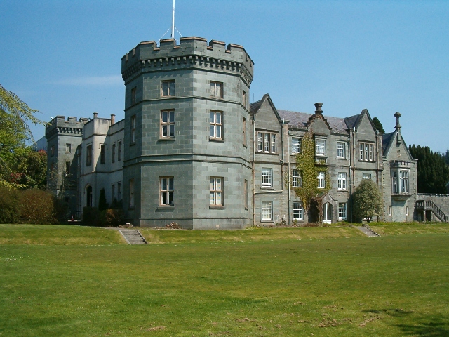
Kilmory Castle

Kilmory Castle, also known as Kilmory House, is a large 19th century house located just to the south of Lochgilphead, in old county Argyll, on the west...

Nearby Amenities

Located within 500m of 55.994722,-5.3367847
Source: PGS
Lat/Long: 55.998435/-5.3341455
Source: PGS
Lat/Long: 55.997984/-5.3343622
Source: PGS
Lat/Long: 55.997175/-5.335581
Source: PGS
Lat/Long: 55.998429/-5.3368024
Source: PGS
Lat/Long: 55.997861/-5.3368342
Source: PGS
Lat/Long: 55.997464/-5.3370742
Source: PGS
Lat/Long: 55.997195/-5.3379346
Created By: dmgroom_coastlines
Source: PGS
Lat/Long: 55.996593/-5.338955
Source: PGS
Lat/Long: 55.996523/-5.3397043
Source: PGS
Lat/Long: 55.996395/-5.3401613
Source: PGS
Lat/Long: 55.996169/-5.3406828
Source: PGS
Lat/Long: 55.995893/-5.3410809
Source: PGS
Lat/Long: 55.99579/-5.3413717
Source: PGS
Lat/Long: 55.995594/-5.3415847
Source: PGS
Lat/Long: 55.995297/-5.3417558
Source: PGS
Lat/Long: 55.995011/-5.3419115
Source: PGS
Lat/Long: 55.994729/-5.3420628
Source: PGS
Lat/Long: 55.994455/-5.3420049
Source: PGS
Lat/Long: 55.993964/-5.3419782
Source: PGS
Lat/Long: 55.9930899/-5.3419418
Source: PGS
Lat/Long: 55.99211/-5.3421009
Rubha an Eheurain
Place: locality
Source Name: OS_OpenData_StreetView
Lat/Long: 55.9982275/-5.3364509
The data included in this document is from www.openstreetmap.org. The data is made available under ODbL.

Have you been to Ballimore?

Leave your review of Ballimore below (or comments, questions and feedback).