Cnoc na Creige Rainich

Hill, Mountain in Ross-shire

Scotland

Cnoc na Creige Rainich

Great Bernera bridges The new bridge under construction and the old white bridge.
Great Bernera bridges Credit: Catherine Morgan

Cnoc na Creige Rainich is a prominent hill located in Ross-shire, Scotland. It is situated in the northwest Highlands, near the village of Achnasheen. With an elevation of approximately 535 meters (1,755 feet), it stands as an imposing feature in the surrounding landscape.

The hill is known for its distinctive rocky terrain, characterized by scattered boulders and outcrops. Its name, Cnoc na Creige Rainich, translates to "Hill of the Ferny Rocks" in Gaelic, which accurately reflects its geological composition. The rocks are primarily composed of Torridonian sandstone, formed during the Precambrian period, making them millions of years old.

Cnoc na Creige Rainich offers stunning panoramic views of the surrounding area. From its summit, one can appreciate the breathtaking vistas of the expansive Loch Maree to the west, as well as the rugged peaks of the Torridon mountains to the north. On a clear day, the distant Isle of Skye can also be seen from the hilltop.

The hill is a popular destination for hikers and outdoor enthusiasts. Several walking trails provide access to Cnoc na Creige Rainich, ranging from moderate to challenging difficulty levels. The ascent offers a rewarding experience, with opportunities to observe local wildlife, including red deer, mountain hares, and golden eagles.

Overall, Cnoc na Creige Rainich is a remarkable natural feature in Ross-shire, with its rocky landscape, stunning views, and recreational opportunities attracting visitors from near and far.

If you have any feedback on the listing, please let us know in the comments section below.

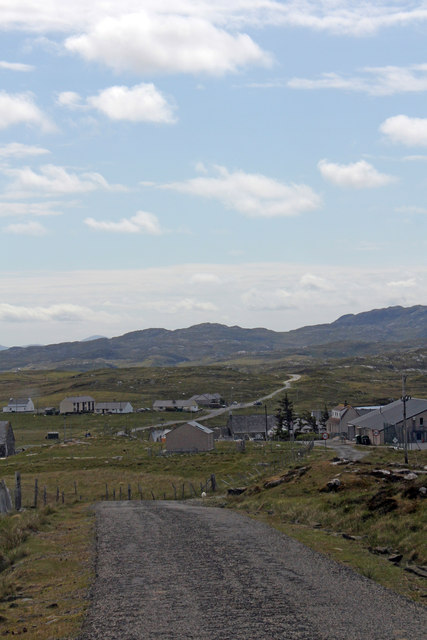
Cnoc na Creige Rainich Images

Images are sourced within 2km of 58.213117/-6.8338782 or Grid Reference NB1635. Thanks to Geograph Open Source API. All images are credited.

Great Bernera bridges The new bridge under construction and the old white bridge.
Great Bernera bridges
The new bridge under construction and the old white bridge.
Moorland and loch on Great Bernera The loch is unnamed on the map, but the Allt Loch an Fheoir flows into it, so this must be Loch an Fheoir.

The houses in the distance are on the road south of Bhalasaigh.
Moorland and loch on Great Bernera
The loch is unnamed on the map, but the Allt Loch an Fheoir flows into it, so this must be Loch an Fheoir. The houses in the distance are on the road south of Bhalasaigh.
"The Bridge Across the Atlantic" Bernera Bridge is one of several bridges which claim to span the Atlantic Ocean. This one connects the Lewis mainland with the island of Great Bernera / Bearnaraigh. Note the standing stones on the far side of the bridge.
<span class="nowrap"><a title="http://www.uigandbernera.com/" rel="nofollow ugc noopener" href="http://www.uigandbernera.com/">Link</a><img style="margin-left:2px;" alt="External link" title="External link - shift click to open in new window" src="https://s1.geograph.org.uk/img/external.png" width="10" height="10"/></span>
"The Bridge Across the Atlantic"
Bernera Bridge is one of several bridges which claim to span the Atlantic Ocean. This one connects the Lewis mainland with the island of Great Bernera / Bearnaraigh. Note the standing stones on the far side of the bridge. LinkExternal link
War Memorial, Breacleit The memorial stands on a mound at the crossroads in the centre of Breacleit / Breaclete, the capital of Great Bernera / Bearnaraigh. On the skyline is the Bernera Community Centre.
<span class="nowrap"><a title="http://www.uigandbernera.com/" rel="nofollow ugc noopener" href="http://www.uigandbernera.com/">Link</a><img style="margin-left:2px;" alt="External link" title="External link - shift click to open in new window" src="https://s1.geograph.org.uk/img/external.png" width="10" height="10"/></span>
War Memorial, Breacleit
The memorial stands on a mound at the crossroads in the centre of Breacleit / Breaclete, the capital of Great Bernera / Bearnaraigh. On the skyline is the Bernera Community Centre. LinkExternal link
Breacleit, Bernera Summer flowers, church and school in the village centre.
<span class="nowrap"><a title="http://www.uigandbernera.com/" rel="nofollow ugc noopener" href="http://www.uigandbernera.com/">Link</a><img style="margin-left:2px;" alt="External link" title="External link - shift click to open in new window" src="https://s1.geograph.org.uk/img/external.png" width="10" height="10"/></span>
Breacleit, Bernera
Summer flowers, church and school in the village centre. LinkExternal link
Loch Ionail Freshwater loch on the island of Great Bernera / Bearnaraigh.
<span class="nowrap"><a title="http://www.uigandbernera.com/" rel="nofollow ugc noopener" href="http://www.uigandbernera.com/">Link</a><img style="margin-left:2px;" alt="External link" title="External link - shift click to open in new window" src="https://s1.geograph.org.uk/img/external.png" width="10" height="10"/></span>
Loch Ionail
Freshwater loch on the island of Great Bernera / Bearnaraigh. LinkExternal link
Tob Bhalasaigh Tidal lagoon with a mix of rare seaweeds on Great Bernera / Bearnaraigh.
<span class="nowrap"><a title="http://www.uigandbernera.com/" rel="nofollow ugc noopener" href="http://www.uigandbernera.com/">Link</a><img style="margin-left:2px;" alt="External link" title="External link - shift click to open in new window" src="https://s1.geograph.org.uk/img/external.png" width="10" height="10"/></span>
Tob Bhalasaigh
Tidal lagoon with a mix of rare seaweeds on Great Bernera / Bearnaraigh. LinkExternal link
Valasay Bridge Carrying the single track road across an outlet of the tidal lagoon, Tob Bhalasaigh on Great Bernera / Bearnaraigh.
<span class="nowrap"><a title="http://www.uigandbernera.com/" rel="nofollow ugc noopener" href="http://www.uigandbernera.com/">Link</a><img style="margin-left:2px;" alt="External link" title="External link - shift click to open in new window" src="https://s1.geograph.org.uk/img/external.png" width="10" height="10"/></span>
Valasay Bridge
Carrying the single track road across an outlet of the tidal lagoon, Tob Bhalasaigh on Great Bernera / Bearnaraigh. LinkExternal link
Shoreline at Tob Bhalasaigh Rocks and heather at the edge of the tidal lagoon in Valasay.
<span class="nowrap"><a title="http://www.uigandbernera.com/" rel="nofollow ugc noopener" href="http://www.uigandbernera.com/">Link</a><img style="margin-left:2px;" alt="External link" title="External link - shift click to open in new window" src="https://s1.geograph.org.uk/img/external.png" width="10" height="10"/></span>
Shoreline at Tob Bhalasaigh
Rocks and heather at the edge of the tidal lagoon in Valasay. LinkExternal link
Bernera Bridge Opened in 1953 and connecting Lewis with Great Bernera / Bearnaraigh.
<span class="nowrap"><a title="http://www.uigandbernera.com/" rel="nofollow ugc noopener" href="http://www.uigandbernera.com/">Link</a><img style="margin-left:2px;" alt="External link" title="External link - shift click to open in new window" src="https://s1.geograph.org.uk/img/external.png" width="10" height="10"/></span>
Bernera Bridge
Opened in 1953 and connecting Lewis with Great Bernera / Bearnaraigh. LinkExternal link
Sea Kayakers by Port a Chruidh Kayakers who have come from Miavaig / Miabhaig and are heading eastwards, having just passed below Bernera Bridge. The mainland of Lewis is on the far side of the 1953 bridge.
<span class="nowrap"><a title="http://www.uigandbernera.com/" rel="nofollow ugc noopener" href="http://www.uigandbernera.com/">Link</a><img style="margin-left:2px;" alt="External link" title="External link - shift click to open in new window" src="https://s1.geograph.org.uk/img/external.png" width="10" height="10"/></span>
Sea Kayakers by Port a Chruidh
Kayakers who have come from Miavaig / Miabhaig and are heading eastwards, having just passed below Bernera Bridge. The mainland of Lewis is on the far side of the 1953 bridge. LinkExternal link
Lewisian Gneiss Pink, folded Lewisian gneiss at the north end of Bernera Bridge. These are amongst the oldest rocks in the world.
<span class="nowrap"><a title="http://www.uigandbernera.com/" rel="nofollow ugc noopener" href="http://www.uigandbernera.com/">Link</a><img style="margin-left:2px;" alt="External link" title="External link - shift click to open in new window" src="https://s1.geograph.org.uk/img/external.png" width="10" height="10"/></span>
Lewisian Gneiss
Pink, folded Lewisian gneiss at the north end of Bernera Bridge. These are amongst the oldest rocks in the world. LinkExternal link
Stone Circle by Bernera Bridge Ancient stone circle on a mound above the north end of the bridge. the stones are part of the famous Callanish complex of standing stones.
Stone Circle by Bernera Bridge
Ancient stone circle on a mound above the north end of the bridge. the stones are part of the famous Callanish complex of standing stones.
Cleitir Stone Circle Calanais VIII - four standing stones above Bernera Bridge and the sound separating the island from Lewis.
Cleitir Stone Circle
Calanais VIII - four standing stones above Bernera Bridge and the sound separating the island from Lewis.
Breacleit church and war memorial Breacleit (or Breaclete) is the largest settlement on Great Bernera, an island off the west coast of Lewis attached to that larger island by a bridge. The little church seen here looks to date from the late C19th or early C20th. To its right can be seen the Bernera War Memorial <span class="nowrap"><a title="http://warmemscot.s4.bizhat.com/viewtopic.php?t=323" rel="nofollow ugc noopener" href="http://warmemscot.s4.bizhat.com/viewtopic.php?t=323">Link</a><img style="margin-left:2px;" alt="External link" title="External link - shift click to open in new window" src="https://s1.geograph.org.uk/img/external.png" width="10" height="10"/></span> 
Behind the church can be seen a little of Loch Breacleit.
Breacleit church and war memorial
Breacleit (or Breaclete) is the largest settlement on Great Bernera, an island off the west coast of Lewis attached to that larger island by a bridge. The little church seen here looks to date from the late C19th or early C20th. To its right can be seen the Bernera War Memorial LinkExternal link Behind the church can be seen a little of Loch Breacleit.
The road to Tacleit For anyone who enjoys driving, this is rather a wonderful sight - a well-maintained twisty lane through open countryside with wonderful views.
The lane leads to the settlement of Tacleit from the village of Breacleit on Great Bernera.
The road to Tacleit
For anyone who enjoys driving, this is rather a wonderful sight - a well-maintained twisty lane through open countryside with wonderful views. The lane leads to the settlement of Tacleit from the village of Breacleit on Great Bernera.
View to the mountains of Harris The massive bulk of the mountains of North Harris command the view southwest from Breacleit on Great Bernera.
View to the mountains of Harris
The massive bulk of the mountains of North Harris command the view southwest from Breacleit on Great Bernera.
Road into Breacleit from Bostadh
Show me another place!

Cnoc na Creige Rainich is located at Grid Ref: NB1635 (Lat: 58.213117, Lng: -6.8338782)

Unitary Authority: Na h-Eileanan an Iar

Police Authority: Highlands and Islands

What 3 Words

///establish.wrist.sliding. Near Carloway, Na h-Eileanan Siar

Related Wikis

Dun Bharabhat, Great Bernera

Dun Bharabhat (or Dun Baravat) is an Iron Age galleried dun or "semi-broch" situated on the island of Great Bernera near Lewis in Scotland (grid reference...

Callanish VIII

The Callanish VIII stone setting is one of many megalithic structures around the better-known (and larger) Calanais I on the west coast of the Isle of...

Breaclete

Breacleit (or Roulanish; Scottish Gaelic: Breacleit; Old Norse: Breiðiklettr) is the central village on Great Bernera in the Outer Hebrides, Scotland....

Great Bernera

Great Bernera (; Scottish Gaelic: Beàrnaraigh Mòr), often known just as Bernera (Scottish Gaelic: Beàrnaraigh), is an island and community in the Outer...

Fuaigh Mòr

Fuaigh Mòr (sometimes anglicised as Vuia Mor) is an island in the Outer Hebrides of Scotland. It is off the west coast of Lewis near Great Bernera in...

Ceabhaigh

Ceabhaigh is a small island in an arm of Loch Ròg on the west coast of Lewis in the Outer Hebrides of Scotland. It is about 25 hectares (62 acres) in extent...

Loch Ròg

Loch Ròg or Loch Roag is a large sea loch on the west coast of Lewis, Outer Hebrides. It is broadly divided into East Loch Roag and West Loch Roag with...

Bernera Riot

The Bernera Riot occurred in 1874, on the island of Great Bernera, in Scotland in response to the Highland Clearances. The use of the term 'Bernera Riot...

Related Videos

Great Bernera, Iron Age House

Great Bernera, Iron Age House, Bosta Beach. Outer Hebrides, Scotland.

The Isle of Great Bernera

Great Bernera is a small island off the coast of a bigger island, the isle of Lewis. Recently, I've been staying on the isle of Lewis ...

A Hebridean Odyssey: Part 15 - Lewis: Great Bernera

This video is the fifteenth in a series that documents a trip taken in May 2022, in which we visited 16 of the Hebridean islands.

Island Of Great Bernera On History Visit To The Outer Hebrides Of Scotland

Tour Scotland short travel video clip, with Scottish music, of the Island Of Great Bernera on ancestry, genealogy, history visit to the ...

Nearby Amenities

Located within 500m of 58.213117,-6.8338782
Passing Place
Lat/Long: 58.214121/-6.8322119
Passing Place
Lat/Long: 58.2105431/-6.8285376
Passing Place
Lat/Long: 58.2129161/-6.8315433
Passing Place
Lat/Long: 58.2116781/-6.8298007
Barrier: cattle_grid
Source: Bing
Lat/Long: 58.2171945/-6.8345321
Passing Place
Lat/Long: 58.2169365/-6.8343584
Power: pole
Lat/Long: 58.2174609/-6.8360973
Power: pole
Lat/Long: 58.21677/-6.8355569
Power: pole
Lat/Long: 58.2161195/-6.8350646
Power: pole
Lat/Long: 58.2153794/-6.8345039
Power: pole
Lat/Long: 58.2146804/-6.8339451
Power: pole
Lat/Long: 58.2138532/-6.8333206
Power: pole
Lat/Long: 58.2130131/-6.832668
Power: pole
Lat/Long: 58.2125052/-6.832144
Power: pole
Lat/Long: 58.2117035/-6.8313507
Power: pole
Lat/Long: 58.2110969/-6.8311222
Power: pole
Lat/Long: 58.2100684/-6.8307593
Power: pole
Lat/Long: 58.2091779/-6.8304579
Power: pole
Lat/Long: 58.2110822/-6.8297802
Power: pole
Lat/Long: 58.211053/-6.8290024
Power: pole
Lat/Long: 58.2110249/-6.8277131
Power: pole
Lat/Long: 58.2110135/-6.8268195
Power: pole
Lat/Long: 58.2105943/-6.8273734
The data included in this document is from www.openstreetmap.org. The data is made available under ODbL.

Have you been to Cnoc na Creige Rainich?

Leave your review of Cnoc na Creige Rainich below (or comments, questions and feedback).