Beinn Fuathabhal
Hill, Mountain in Ross-shire
Scotland
Beinn Fuathabhal
Beinn Fuathabhal is a prominent hill located in Ross-shire, in the northern part of the Scottish Highlands. It stands at an impressive height of around 901 meters (2,956 feet) and is part of the rugged landscape of the Northwest Highlands Geopark.
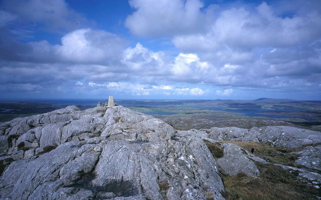
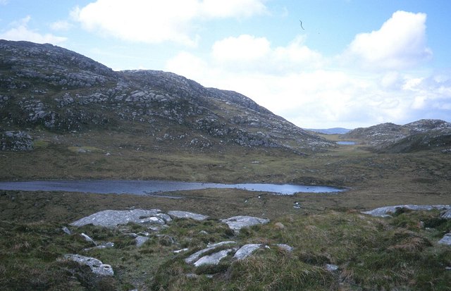
The hill is characterized by its distinctive conical shape and steep slopes, covered in heather and grasses. Its summit is marked by a trig point, offering breathtaking panoramic views of the surrounding area, including the picturesque Loch Broom to the west and the stunning mountains of Coigach and Assynt to the north.
Beinn Fuathabhal is a popular destination for hikers and mountaineers, who are attracted by its challenging terrain and stunning vistas. There are various routes to reach the summit, with the most common approach starting from the village of Ullapool to the southeast. The ascent involves a steep and rocky climb, requiring a good level of fitness and experience in hillwalking.
The hill is also renowned for its rich biodiversity. It is home to a variety of bird species, including golden eagles, peregrine falcons, and red grouse, making it a favorite spot for birdwatching enthusiasts. The surrounding moorland habitat supports a range of plant species, such as heather, sphagnum moss, and bog cotton.
Overall, Beinn Fuathabhal offers a challenging and rewarding outdoor experience, combining stunning natural beauty, diverse wildlife, and breathtaking views of the Scottish Highlands.
If you have any feedback on the listing, please let us know in the comments section below.
Beinn Fuathabhal Images
Images are sourced within 2km of 58.179291/-6.8318131 or Grid Reference NB1631. Thanks to Geograph Open Source API. All images are credited.
Beinn Fuathabhal is located at Grid Ref: NB1631 (Lat: 58.179291, Lng: -6.8318131)
Unitary Authority: Na h-Eileanan an Iar
Police Authority: Highlands and Islands
What 3 Words
///calm.spenders.dispensed. Near Carloway, Na h-Eileanan Siar
Nearby Locations
Related Wikis

Callanish VIII
The Callanish VIII stone setting is one of many megalithic structures around the better-known (and larger) Calanais I on the west coast of the Isle of...

Dun Bharabhat, Great Bernera
Dun Bharabhat (or Dun Baravat) is an Iron Age galleried dun or "semi-broch" situated on the island of Great Bernera near Lewis in Scotland (grid reference...

Fuaigh Beag
Fuaigh Beag or Vuia Be(a)g is an island in the Outer Hebrides. It is off the west coast of Lewis near Great Bernera in Loch Roag. Its name means "little...
Loch Ròg
Loch Ròg or Loch Roag is a large sea loch on the west coast of Lewis, Outer Hebrides. It is broadly divided into East Loch Roag and West Loch Roag with...
Eilean Chearstaidh
Eilean Kearstay (Scottish Gaelic: Eilean Chearstaigh) is an uninhabited island in Loch Roag in the Outer Hebrides of Scotland. It lies south east of Great...
Fuaigh Mòr
Fuaigh Mòr (sometimes anglicised as Vuia Mor) is an island in the Outer Hebrides of Scotland. It is off the west coast of Lewis near Great Bernera in...
Ceabhaigh
Ceabhaigh is a small island in an arm of Loch Ròg on the west coast of Lewis in the Outer Hebrides of Scotland. It is about 25 hectares (62 acres) in extent...

Callanish Stones
The Callanish Stones (or "Callanish I": Scottish Gaelic: Clachan Chalanais or Tursachan Chalanais) are an arrangement of standing stones placed in a cruciform...
Have you been to Beinn Fuathabhal?
Leave your review of Beinn Fuathabhal below (or comments, questions and feedback).