Cnoc an Ois

Hill, Mountain in Ross-shire

Scotland

Cnoc an Ois

A slipway in Loch Miabhaig
A slipway in Loch Miabhaig Credit: Alan Reid

Cnoc an Ois is a hill located in Ross-shire, Scotland. It is part of the larger mountain range known as the Northwest Highlands. The hill stands at an elevation of approximately 1,057 feet (322 meters) above sea level.

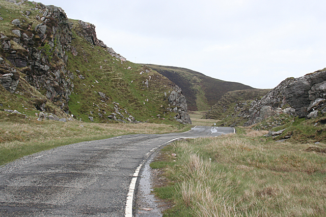
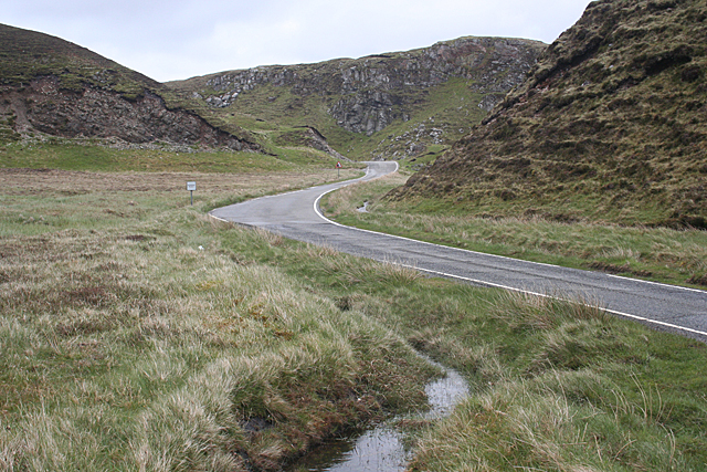
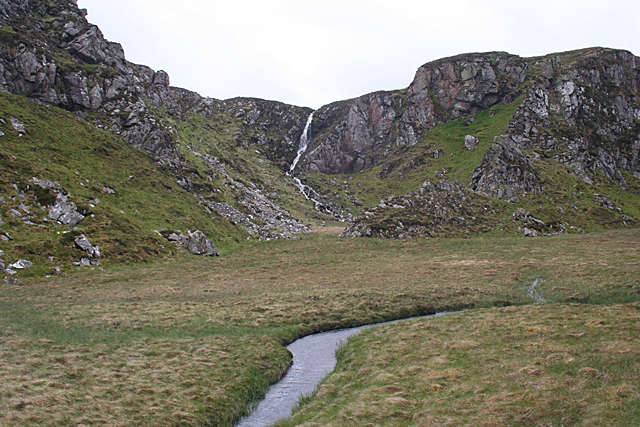
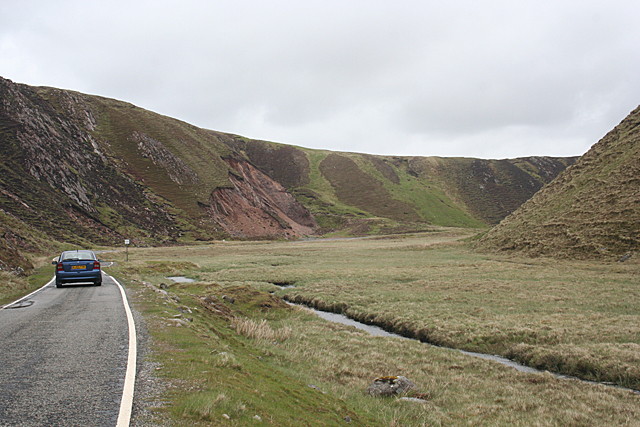
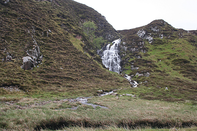
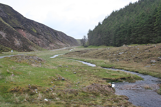
Cnoc an Ois is known for its rugged terrain and stunning views of the surrounding landscape. The hill is covered in heather and grasses, with rocky outcrops scattered throughout. Hikers and outdoor enthusiasts frequent the area to take in the natural beauty and challenge themselves with the steep slopes and rocky paths.

The hill is also home to a variety of wildlife, including red deer, mountain hares, and various bird species. The area is considered a haven for nature lovers and photographers looking to capture the beauty of the Scottish Highlands.

Visitors to Cnoc an Ois can enjoy a peaceful and remote setting, with the opportunity to explore the hill on foot or by bike. The hill is easily accessible from nearby towns and villages, making it a popular destination for day trips and outdoor adventures.

If you have any feedback on the listing, please let us know in the comments section below.

Cnoc an Ois Images

Images are sourced within 2km of 58.204072/-6.9785949 or Grid Reference NB0734. Thanks to Geograph Open Source API. All images are credited.

A slipway in Loch Miabhaig
Gleann Bhaltois (Glen Valtos) 1 Gleann Bhaltois is a spectacular example of a glacial meltwater channel. At the end of the last Ice Age, about 10,000 years ago, there is thought to have been a lake where Uig Bay now lies, dammed by ice to the west. The outlet from the lake was at the head of what is now Gleann Bhaltois, and carved a deep steep-sided glen, exploiting a fault line in the rocks. This is taken from the col at the top of the glen, looking down along the B8011 road which now occupies it.
Gleann Bhaltois (Glen Valtos) 1
Gleann Bhaltois is a spectacular example of a glacial meltwater channel. At the end of the last Ice Age, about 10,000 years ago, there is thought to have been a lake where Uig Bay now lies, dammed by ice to the west. The outlet from the lake was at the head of what is now Gleann Bhaltois, and carved a deep steep-sided glen, exploiting a fault line in the rocks. This is taken from the col at the top of the glen, looking down along the B8011 road which now occupies it.
Gleann Bhaltois (Glen Valtos) 2 Gleann Bhaltois is a spectacular example of a glacial meltwater channel. At the end of the last Ice Age, about 10,000 years ago, there is thought to have been a lake where Uig Bay now lies, dammed by ice to the west. The outlet from the lake was at the head of what is now Gleann Bhaltois, and carved a deep steep-sided glen, exploiting a fault line in the rocks. However the upper part of the glen follows a more sinuous course. The single-track B8011 road with passing places now winds through the glen.
Gleann Bhaltois (Glen Valtos) 2
Gleann Bhaltois is a spectacular example of a glacial meltwater channel. At the end of the last Ice Age, about 10,000 years ago, there is thought to have been a lake where Uig Bay now lies, dammed by ice to the west. The outlet from the lake was at the head of what is now Gleann Bhaltois, and carved a deep steep-sided glen, exploiting a fault line in the rocks. However the upper part of the glen follows a more sinuous course. The single-track B8011 road with passing places now winds through the glen.
Gleann Bhaltois (Glen Valtos) 3 Gleann Bhaltois is a spectacular example of a glacial meltwater channel. At the end of the last Ice Age, about 10,000 years ago, there is thought to have been a lake where Uig Bay now lies, dammed by ice to the west. The outlet from the lake was at the head of what is now Gleann Bhaltois, and carved a deep steep-sided glen, exploiting a fault line in the rocks. A classic and diagnostic feature of a meltwater channels is that it contains a stream much too small to have carved it in the first place.
Gleann Bhaltois (Glen Valtos) 3
Gleann Bhaltois is a spectacular example of a glacial meltwater channel. At the end of the last Ice Age, about 10,000 years ago, there is thought to have been a lake where Uig Bay now lies, dammed by ice to the west. The outlet from the lake was at the head of what is now Gleann Bhaltois, and carved a deep steep-sided glen, exploiting a fault line in the rocks. A classic and diagnostic feature of a meltwater channels is that it contains a stream much too small to have carved it in the first place.
Gleann Bhaltois (Glen Valtos) 4 Gleann Bhaltois is a spectacular example of a glacial meltwater channel. At the end of the last Ice Age, about 10,000 years ago, there is thought to have been a lake where Uig Bay now lies, dammed by ice to the west. The outlet from the lake was at the head of what is now Gleann Bhaltois, and carved a deep steep-sided glen, exploiting a fault line in the rocks.
Gleann Bhaltois (Glen Valtos) 4
Gleann Bhaltois is a spectacular example of a glacial meltwater channel. At the end of the last Ice Age, about 10,000 years ago, there is thought to have been a lake where Uig Bay now lies, dammed by ice to the west. The outlet from the lake was at the head of what is now Gleann Bhaltois, and carved a deep steep-sided glen, exploiting a fault line in the rocks.
Gleann Bhaltois (Glen Valtos) 5 Gleann Bhaltois is a spectacular example of a glacial meltwater channel. At the end of the last Ice Age, about 10,000 years ago, there is thought to have been a lake where Uig Bay now lies, dammed by ice to the west. The outlet from the lake was at the head of what is now Gleann Bhaltois, and carved a deep steep-sided glen, exploiting a fault line in the rocks. Following several wet days, a waterfall is draining the moor above.
Gleann Bhaltois (Glen Valtos) 5
Gleann Bhaltois is a spectacular example of a glacial meltwater channel. At the end of the last Ice Age, about 10,000 years ago, there is thought to have been a lake where Uig Bay now lies, dammed by ice to the west. The outlet from the lake was at the head of what is now Gleann Bhaltois, and carved a deep steep-sided glen, exploiting a fault line in the rocks. Following several wet days, a waterfall is draining the moor above.
Gleann Bhaltois (Glen Valtos) 6 Gleann Bhaltois is a spectacular example of a glacial meltwater channel. At the end of the last Ice Age, about 10,000 years ago, there is thought to have been a lake where Uig Bay now lies, dammed by ice to the west. The outlet from the lake was at the head of what is now Gleann Bhaltois, and carved a deep steep-sided glen, exploiting a fault line in the rocks. At this point, the glen steps down from its winding upper course through a rock fall to the much straighter lower course.
Gleann Bhaltois (Glen Valtos) 6
Gleann Bhaltois is a spectacular example of a glacial meltwater channel. At the end of the last Ice Age, about 10,000 years ago, there is thought to have been a lake where Uig Bay now lies, dammed by ice to the west. The outlet from the lake was at the head of what is now Gleann Bhaltois, and carved a deep steep-sided glen, exploiting a fault line in the rocks. At this point, the glen steps down from its winding upper course through a rock fall to the much straighter lower course.
Gleann Bhaltois (Glen Valtos) 7 Gleann Bhaltois is a spectacular example of a glacial meltwater channel. At the end of the last Ice Age, about 10,000 years ago, there is thought to have been a lake where Uig Bay now lies, dammed by ice to the west. The outlet from the lake was at the head of what is now Gleann Bhaltois, and carved a deep steep-sided glen, exploiting a fault line in the rocks. From this point, the glen follows the straight line of the fault. The classic and diagnostic feature of a meltwater channel, well seen in this view, is that the stream it contains is too small to have carved it in the first place.
Gleann Bhaltois (Glen Valtos) 7
Gleann Bhaltois is a spectacular example of a glacial meltwater channel. At the end of the last Ice Age, about 10,000 years ago, there is thought to have been a lake where Uig Bay now lies, dammed by ice to the west. The outlet from the lake was at the head of what is now Gleann Bhaltois, and carved a deep steep-sided glen, exploiting a fault line in the rocks. From this point, the glen follows the straight line of the fault. The classic and diagnostic feature of a meltwater channel, well seen in this view, is that the stream it contains is too small to have carved it in the first place.
Gleann Bhaltois (Glen Valtos) 7 Gleann Bhaltois is a spectacular example of a glacial meltwater channel. At the end of the last Ice Age, about 10,000 years ago, there is thought to have been a lake where Uig Bay now lies, dammed by ice to the west. The outlet from the lake was at the head of what is now Gleann Bhaltois, and carved a deep steep-sided glen, exploiting a fault line in the rocks.
Gleann Bhaltois (Glen Valtos) 7
Gleann Bhaltois is a spectacular example of a glacial meltwater channel. At the end of the last Ice Age, about 10,000 years ago, there is thought to have been a lake where Uig Bay now lies, dammed by ice to the west. The outlet from the lake was at the head of what is now Gleann Bhaltois, and carved a deep steep-sided glen, exploiting a fault line in the rocks.
Miabhaig harbour pontoon View from RIB afloat to pontoon at Miabhaig, Ceann A Tuath Na Hearadh (North Harris).  Compare to <a href="https://www.geograph.org.uk/photo/575251">NB0934 : Miabhaig Jetty</a> taken by Dave Fergusson on 1 Oct 2007.
Miabhaig harbour pontoon
View from RIB afloat to pontoon at Miabhaig, Ceann A Tuath Na Hearadh (North Harris). Compare to NB0934 : Miabhaig Jetty taken by Dave Fergusson on 1 Oct 2007.
If you are ever up this way... RIB moored alongside Miabhaig pontoon <a href="https://www.geograph.org.uk/photo/2429707">NB0934 : Miabhaig harbour pontoon</a> on Ceann A Tuath Na Hearadah (North Harris) from which we enjoyed a great trip.  (No financial benefit in anyway to me from posting this; simply a community service.)
If you are ever up this way...
RIB moored alongside Miabhaig pontoon NB0934 : Miabhaig harbour pontoon on Ceann A Tuath Na Hearadah (North Harris) from which we enjoyed a great trip. (No financial benefit in anyway to me from posting this; simply a community service.)
Tràigh na Clibhe on the Isle of Lewis This beautiful north-facing beach, Tràigh na Clibhe, is popular with surfers (two are just visible beyond the lone figure). It is protected on both sides by 50 foot high cliffs (not in view here, but see <a title="https://www.geograph.org.uk/photo/1618866" href="https://www.geograph.org.uk/photo/1618866">Link</a> )
Tràigh na Clibhe on the Isle of Lewis
This beautiful north-facing beach, Tràigh na Clibhe, is popular with surfers (two are just visible beyond the lone figure). It is protected on both sides by 50 foot high cliffs (not in view here, but see Link )
Tràigh na Clibhe On the skyline is the low headland which marks the left edge of Tràigh na Clibhe beach. This north-facing beach is also protected on both sides by 50 foot high cliffs (not in view here, but see <a title="https://www.geograph.org.uk/photo/1618866" href="https://www.geograph.org.uk/photo/1618866">Link</a> ). In the hinterland is the village of Cliobh (Cliff) to the south and the town of Bhaltos (Valtos) to the east, providing several alternative names for this popular beach.
Tràigh na Clibhe
On the skyline is the low headland which marks the left edge of Tràigh na Clibhe beach. This north-facing beach is also protected on both sides by 50 foot high cliffs (not in view here, but see Link ). In the hinterland is the village of Cliobh (Cliff) to the south and the town of Bhaltos (Valtos) to the east, providing several alternative names for this popular beach.
Pontoon at Miabhaig Where Seatrek offer a variety of adventurous seaborne trips around Lewis and Harris as well as to distant St Kilda.
 <span class="nowrap"><a title="http://www.seatrek.co.uk/" rel="nofollow ugc noopener" href="http://www.seatrek.co.uk/">Link</a><img style="margin-left:2px;" alt="External link" title="External link - shift click to open in new window" src="https://s1.geograph.org.uk/img/external.png" width="10" height="10"/></span>
Pontoon at Miabhaig
Where Seatrek offer a variety of adventurous seaborne trips around Lewis and Harris as well as to distant St Kilda. LinkExternal link
Boats at Miabhaig Fishing boat and a more adventurous RIB at Seatrek's jetty on Loch Miabhaig, a sea loch.
<span class="nowrap"><a title="http://www.seatrek.co.uk/" rel="nofollow ugc noopener" href="http://www.seatrek.co.uk/">Link</a><img style="margin-left:2px;" alt="External link" title="External link - shift click to open in new window" src="https://s1.geograph.org.uk/img/external.png" width="10" height="10"/></span>
Boats at Miabhaig
Fishing boat and a more adventurous RIB at Seatrek's jetty on Loch Miabhaig, a sea loch. LinkExternal link
Miavaig / Miabhaig Village Crofting and fishing village on the shore of Loch Miabhaig.
Miavaig / Miabhaig Village
Crofting and fishing village on the shore of Loch Miabhaig.
Miabhaig, Loch Rog an Iar The crofting / fishing village is located at the western head of the sea loch, West Loch Roag. Note the rafts in the middle of the loch.
Miabhaig, Loch Rog an Iar
The crofting / fishing village is located at the western head of the sea loch, West Loch Roag. Note the rafts in the middle of the loch.
Show me another place!

Cnoc an Ois is located at Grid Ref: NB0734 (Lat: 58.204072, Lng: -6.9785949)

Unitary Authority: Na h-Eileanan an Iar

Police Authority: Highlands and Islands

What 3 Words

///teach.illogical.facelift. Near Carloway, Na h-Eileanan Siar

Related Wikis

Cliff, Lewis

Cliff (Scottish Gaelic: Cliobh) is a small settlement on the Isle of Lewis, in the Outer Hebrides, Scotland. Cliff is within the parish of Uig. The settlement...

Camas Uig

Camas Uig (Uig Bay) is a bay on the west coast of the Isle of Lewis, in the Outer Hebrides of Scotland. The Lewis Chessmen were discovered in the dunes...

Kneep

Kneep (Scottish Gaelic: Cnìp) is a village on the Isle of Lewis, in the Outer Hebrides, Scotland. Kneep is within the parish of Uig.Various archaeological...

Timsgarry

Timsgarry (Scottish Gaelic: Tuimisgearraidh) is a village on the Isle of Lewis, in the Outer Hebrides, Scotland. Timsgarry is home to the Baile na Cille...

Nearby Amenities

Located within 500m of 58.204072,-6.9785949
Passing Place
Lat/Long: 58.2019519/-6.9822562
Power: pole
Lat/Long: 58.2043407/-6.9705446
Power: pole
Lat/Long: 58.2042999/-6.9716545
Power: pole
Lat/Long: 58.2042472/-6.9727393
Power: pole
Lat/Long: 58.2041755/-6.974202
Power: pole
Lat/Long: 58.2041172/-6.9752505
Power: pole
Lat/Long: 58.2040034/-6.9774588
Power: pole
Lat/Long: 58.2039521/-6.9785287
Power: pole
Lat/Long: 58.2037772/-6.9798089
Power: pole
Lat/Long: 58.2035958/-6.9813012
Power: pole
Lat/Long: 58.2034377/-6.9824487
Power: pole
Lat/Long: 58.2032847/-6.983479
Power: pole
Lat/Long: 58.2031132/-6.9848226
Power: pole
Lat/Long: 58.2029336/-6.9860936
Passing Place
Lat/Long: 58.2022674/-6.9812594
The data included in this document is from www.openstreetmap.org. The data is made available under ODbL.

Have you been to Cnoc an Ois?

Leave your review of Cnoc an Ois below (or comments, questions and feedback).