Sìdhean Mòr

Hill, Mountain in Ross-shire

Scotland

Sìdhean Mòr

Gob Geòdha nam Bradan
Gob Geòdha nam Bradan Credit: Sandy Gerrard

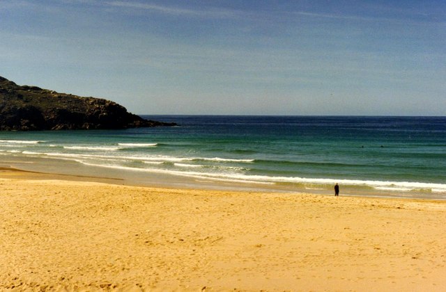
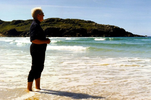
Sìdhean Mòr, located in Ross-shire, Scotland, is a prominent hill/mountain that stands as an imposing natural landmark in the region. With a height of approximately 723 meters (2,372 feet), it offers breathtaking panoramic views of the surrounding landscape. Sìdhean Mòr is part of the Torridon Hills, a mountain range renowned for its rugged beauty and dramatic scenery.

The mountain is characterized by its steep slopes, rocky terrain, and a distinctive pointed peak. Its geological composition consists primarily of Torridonian sandstone, which gives it a unique reddish hue. Sìdhean Mòr is a popular hiking destination for outdoor enthusiasts, offering various challenging routes and rewarding experiences for climbers and walkers alike.

The hill/mountain is also home to a diverse range of flora and fauna. Its lower slopes are covered in heather, while higher elevations are adorned with mountain grasses and mosses. Wildlife such as red deer, golden eagles, and ptarmigan can often be spotted in the area, adding to the natural beauty and allure of Sìdhean Mòr.

The summit of Sìdhean Mòr provides panoramic vistas of lochs, glens, and other neighboring peaks, including Liathach and Beinn Eighe. On clear days, it is even possible to see the Isle of Skye in the distance. The mountain's commanding presence, combined with its stunning landscapes and rich biodiversity, make Sìdhean Mòr a captivating destination for nature lovers and adventurers seeking to explore the Scottish Highlands.

If you have any feedback on the listing, please let us know in the comments section below.
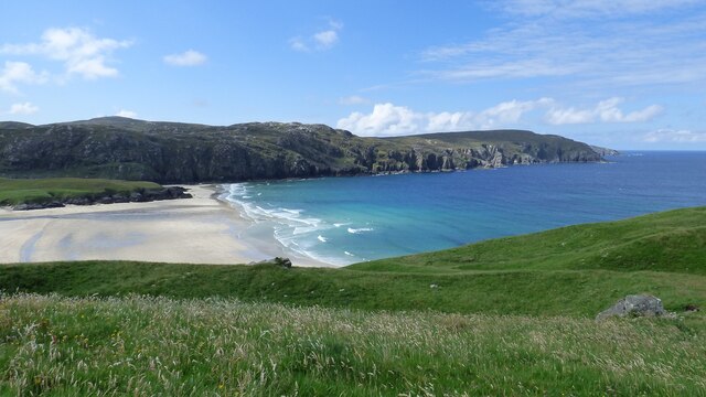
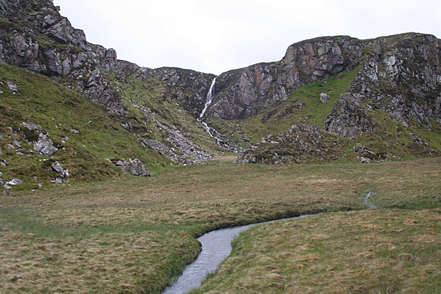
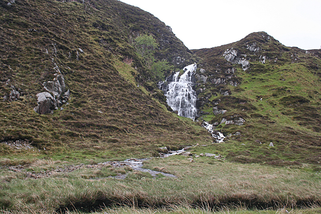
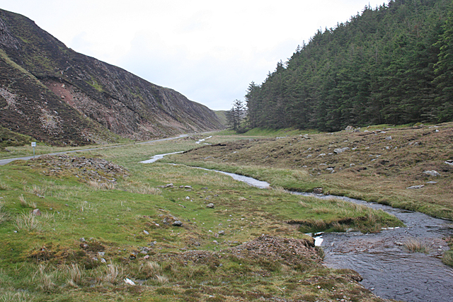
Sìdhean Mòr Images

Images are sourced within 2km of 58.217351/-6.9818223 or Grid Reference NB0736. Thanks to Geograph Open Source API. All images are credited.

Gob Geòdha nam Bradan
Sheepfold at Tobha Mòr
Sheepfold and boundary wall near Tobha Mòr
Gleann Bhaltois (Glen Valtos) 3 Gleann Bhaltois is a spectacular example of a glacial meltwater channel. At the end of the last Ice Age, about 10,000 years ago, there is thought to have been a lake where Uig Bay now lies, dammed by ice to the west. The outlet from the lake was at the head of what is now Gleann Bhaltois, and carved a deep steep-sided glen, exploiting a fault line in the rocks. A classic and diagnostic feature of a meltwater channels is that it contains a stream much too small to have carved it in the first place.
Gleann Bhaltois (Glen Valtos) 3
Gleann Bhaltois is a spectacular example of a glacial meltwater channel. At the end of the last Ice Age, about 10,000 years ago, there is thought to have been a lake where Uig Bay now lies, dammed by ice to the west. The outlet from the lake was at the head of what is now Gleann Bhaltois, and carved a deep steep-sided glen, exploiting a fault line in the rocks. A classic and diagnostic feature of a meltwater channels is that it contains a stream much too small to have carved it in the first place.
Gleann Bhaltois (Glen Valtos) 5 Gleann Bhaltois is a spectacular example of a glacial meltwater channel. At the end of the last Ice Age, about 10,000 years ago, there is thought to have been a lake where Uig Bay now lies, dammed by ice to the west. The outlet from the lake was at the head of what is now Gleann Bhaltois, and carved a deep steep-sided glen, exploiting a fault line in the rocks. Following several wet days, a waterfall is draining the moor above.
Gleann Bhaltois (Glen Valtos) 5
Gleann Bhaltois is a spectacular example of a glacial meltwater channel. At the end of the last Ice Age, about 10,000 years ago, there is thought to have been a lake where Uig Bay now lies, dammed by ice to the west. The outlet from the lake was at the head of what is now Gleann Bhaltois, and carved a deep steep-sided glen, exploiting a fault line in the rocks. Following several wet days, a waterfall is draining the moor above.
Gleann Bhaltois (Glen Valtos) 6 Gleann Bhaltois is a spectacular example of a glacial meltwater channel. At the end of the last Ice Age, about 10,000 years ago, there is thought to have been a lake where Uig Bay now lies, dammed by ice to the west. The outlet from the lake was at the head of what is now Gleann Bhaltois, and carved a deep steep-sided glen, exploiting a fault line in the rocks. At this point, the glen steps down from its winding upper course through a rock fall to the much straighter lower course.
Gleann Bhaltois (Glen Valtos) 6
Gleann Bhaltois is a spectacular example of a glacial meltwater channel. At the end of the last Ice Age, about 10,000 years ago, there is thought to have been a lake where Uig Bay now lies, dammed by ice to the west. The outlet from the lake was at the head of what is now Gleann Bhaltois, and carved a deep steep-sided glen, exploiting a fault line in the rocks. At this point, the glen steps down from its winding upper course through a rock fall to the much straighter lower course.
Gleann Bhaltois (Glen Valtos) 7 Gleann Bhaltois is a spectacular example of a glacial meltwater channel. At the end of the last Ice Age, about 10,000 years ago, there is thought to have been a lake where Uig Bay now lies, dammed by ice to the west. The outlet from the lake was at the head of what is now Gleann Bhaltois, and carved a deep steep-sided glen, exploiting a fault line in the rocks. From this point, the glen follows the straight line of the fault. The classic and diagnostic feature of a meltwater channel, well seen in this view, is that the stream it contains is too small to have carved it in the first place.
Gleann Bhaltois (Glen Valtos) 7
Gleann Bhaltois is a spectacular example of a glacial meltwater channel. At the end of the last Ice Age, about 10,000 years ago, there is thought to have been a lake where Uig Bay now lies, dammed by ice to the west. The outlet from the lake was at the head of what is now Gleann Bhaltois, and carved a deep steep-sided glen, exploiting a fault line in the rocks. From this point, the glen follows the straight line of the fault. The classic and diagnostic feature of a meltwater channel, well seen in this view, is that the stream it contains is too small to have carved it in the first place.
Gleann Bhaltois (Glen Valtos) 7 Gleann Bhaltois is a spectacular example of a glacial meltwater channel. At the end of the last Ice Age, about 10,000 years ago, there is thought to have been a lake where Uig Bay now lies, dammed by ice to the west. The outlet from the lake was at the head of what is now Gleann Bhaltois, and carved a deep steep-sided glen, exploiting a fault line in the rocks.
Gleann Bhaltois (Glen Valtos) 7
Gleann Bhaltois is a spectacular example of a glacial meltwater channel. At the end of the last Ice Age, about 10,000 years ago, there is thought to have been a lake where Uig Bay now lies, dammed by ice to the west. The outlet from the lake was at the head of what is now Gleann Bhaltois, and carved a deep steep-sided glen, exploiting a fault line in the rocks.
Tràigh na Clibhe on the Isle of Lewis This beautiful north-facing beach, Tràigh na Clibhe, is popular with surfers (two are just visible beyond the lone figure). It is protected on both sides by 50 foot high cliffs (not in view here, but see <a title="https://www.geograph.org.uk/photo/1618866" href="https://www.geograph.org.uk/photo/1618866">Link</a> )
Tràigh na Clibhe on the Isle of Lewis
This beautiful north-facing beach, Tràigh na Clibhe, is popular with surfers (two are just visible beyond the lone figure). It is protected on both sides by 50 foot high cliffs (not in view here, but see Link )
Tràigh na Clibhe On the skyline is the low headland which marks the left edge of Tràigh na Clibhe beach. This north-facing beach is also protected on both sides by 50 foot high cliffs (not in view here, but see <a title="https://www.geograph.org.uk/photo/1618866" href="https://www.geograph.org.uk/photo/1618866">Link</a> ). In the hinterland is the village of Cliobh (Cliff) to the south and the town of Bhaltos (Valtos) to the east, providing several alternative names for this popular beach.
Tràigh na Clibhe
On the skyline is the low headland which marks the left edge of Tràigh na Clibhe beach. This north-facing beach is also protected on both sides by 50 foot high cliffs (not in view here, but see Link ). In the hinterland is the village of Cliobh (Cliff) to the south and the town of Bhaltos (Valtos) to the east, providing several alternative names for this popular beach.
Miavaig / Miabhaig Village Crofting and fishing village on the shore of Loch Miabhaig.
Miavaig / Miabhaig Village
Crofting and fishing village on the shore of Loch Miabhaig.
Glen Valtos / Gleann Bhaltois Steep-sided and narrow glen, with a rare wood for Lewis, running between Miabhaig and Uig.
Glen Valtos / Gleann Bhaltois
Steep-sided and narrow glen, with a rare wood for Lewis, running between Miabhaig and Uig.
Traigh na Clibhe North-west facing bay, backed by sand dunes, north of Cliobh.
Traigh na Clibhe
North-west facing bay, backed by sand dunes, north of Cliobh.
Bhaltos / Valtos Community of crofts, fishermen's houses and holiday homes on Pabbay Sound / Caolas Phabaigh.
Bhaltos / Valtos
Community of crofts, fishermen's houses and holiday homes on Pabbay Sound / Caolas Phabaigh.
Gleann Bhaltois Glen following geological fault line.
Gleann Bhaltois
Glen following geological fault line.
Tràigh na Clibhe
Tràigh na Clibhe
Fleeced! Fleeces hanging on fence of cottage at Bhaltos.
Fleeced!
Fleeces hanging on fence of cottage at Bhaltos.
Traigh na Clibhe Beautiful sandy beach and clear blue water at Clibhe.
Traigh na Clibhe
Beautiful sandy beach and clear blue water at Clibhe.
Show me another place!

Sìdhean Mòr is located at Grid Ref: NB0736 (Lat: 58.217351, Lng: -6.9818223)

Unitary Authority: Na h-Eileanan an Iar

Police Authority: Highlands and Islands

What 3 Words

///library.distorts.braked. Near Carloway, Na h-Eileanan Siar

Related Wikis

Cliff, Lewis

Cliff (Scottish Gaelic: Cliobh) is a small settlement on the Isle of Lewis, in the Outer Hebrides, Scotland. Cliff is within the parish of Uig. The settlement...

Kneep

Kneep (Scottish Gaelic: Cnìp) is a village on the Isle of Lewis, in the Outer Hebrides, Scotland. Kneep is within the parish of Uig.Various archaeological...

Camas Uig

Camas Uig (Uig Bay) is a bay on the west coast of the Isle of Lewis, in the Outer Hebrides of Scotland. The Lewis Chessmen were discovered in the dunes...

Loch na Berie

Loch Na Berie is a broch in the Outer Hebrides of Scotland, located approximately 400 yards from the shore, and is thought to have been located on an island...

Nearby Amenities

Located within 500m of 58.217351,-6.9818223
The data included in this document is from www.openstreetmap.org. The data is made available under ODbL.

Have you been to Sìdhean Mòr?

Leave your review of Sìdhean Mòr below (or comments, questions and feedback).