Crow Down

Downs, Moorland in Kent Ashford

England

Crow Down

Ordnance Survey Flush Bracket G1846 This can be found on the wall of Springfield House - a private dwelling - adjacent to Springfield Stores.
For more detail see : <span class="nowrap"><a title="http://www.bench-marks.org.uk/bm13606" rel="nofollow ugc noopener" href="http://www.bench-marks.org.uk/bm13606">Link</a><img style="margin-left:2px;" alt="External link" title="External link - shift click to open in new window" src="https://s1.geograph.org.uk/img/external.png" width="10" height="10"/></span>
Ordnance Survey Flush Bracket G1846 Credit: Peter Wood

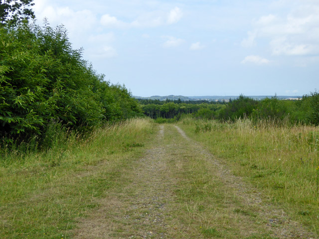
Crow Down is a picturesque area located in Kent, England, known for its stunning natural beauty and diverse range of landscapes. Situated in the heart of the Kent Downs, Crow Down is a prime example of the region's unique combination of downs and moorland.

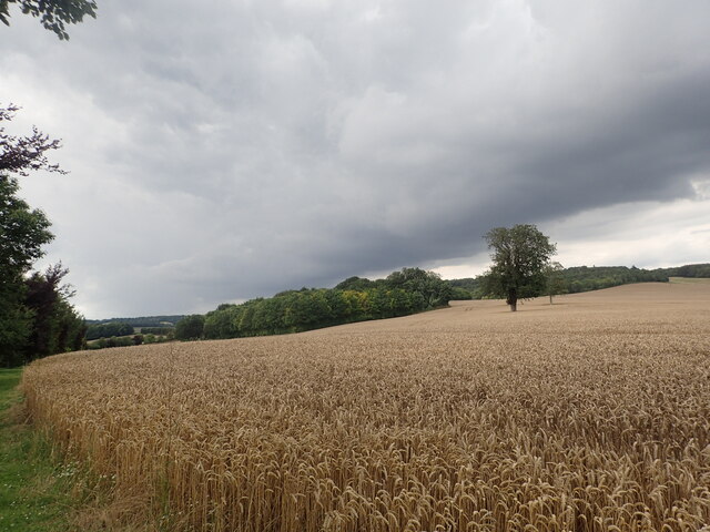
Covering an extensive area, Crow Down boasts rolling hills covered with lush green grass, providing a haven for a variety of plant and animal species. The downs are characterized by their open and expansive views, offering visitors breathtaking panoramas of the surrounding countryside. The moorland areas, on the other hand, are home to a more rugged terrain, with heather-covered hills and rocky outcrops.

The diverse ecology of Crow Down is a result of its rich and varied soil types, which support a wide range of plant life, including wildflowers, grasses, and shrubs. This, in turn, attracts a plethora of bird species, making it a haven for birdwatchers and nature enthusiasts. Visitors may spot the likes of skylarks, stonechats, and kestrels, among others.

The area is also popular for outdoor activities such as hiking, cycling, and horseback riding, with numerous trails and paths winding through the downs and moorland. These activities provide an opportunity for visitors to explore the natural beauty of Crow Down up close and immerse themselves in its tranquil ambiance.

In summary, Crow Down in Kent is a captivating destination that showcases the beauty of the Kent Downs and moorland landscapes. With its diverse flora and fauna, breathtaking views, and recreational opportunities, it offers visitors a unique and enriching experience in nature.

If you have any feedback on the listing, please let us know in the comments section below.

Crow Down Images

Images are sourced within 2km of 51.205488/0.89326202 or Grid Reference TR0249. Thanks to Geograph Open Source API. All images are credited.

Ordnance Survey Flush Bracket G1846 This can be found on the wall of Springfield House - a private dwelling - adjacent to Springfield Stores.
For more detail see : <span class="nowrap"><a title="http://www.bench-marks.org.uk/bm13606" rel="nofollow ugc noopener" href="http://www.bench-marks.org.uk/bm13606">Link</a><img style="margin-left:2px;" alt="External link" title="External link - shift click to open in new window" src="https://s1.geograph.org.uk/img/external.png" width="10" height="10"/></span>
Ordnance Survey Flush Bracket G1846
This can be found on the wall of Springfield House - a private dwelling - adjacent to Springfield Stores. For more detail see : LinkExternal link
Church Lane entering Challock Lees Looking north-eastward.
Church Lane entering Challock Lees
Looking north-eastward.
Bungalow on Buck Street, Challock
Track, King's Wood Through Forestry Commission woodland.
Track, King's Wood
Through Forestry Commission woodland.
Path, Kings Wood Through Forestry Commission woodland.
Path, Kings Wood
Through Forestry Commission woodland.
Track, King's Wood Through Forestry Commission woodland.
Track, King's Wood
Through Forestry Commission woodland.
Old Milestone by the A251, Buck Street, Challock Metal plate attached to stone post by the A251, in parish of Challock (Ashford District), Buck Street, South of Blind Lane, in ferns behind path, on West side of road. Faversham iron plate, erected by the Faversham to Hythe & Canterbury turnpike trust in the 19th century. 

Inscription reads:-
FAVERSHAM
7 MILES
ASHFORD
6 MILES
Rivet benchmark on top.

Grade II listed.  
List Entry Number: 1246645 <span class="nowrap"><a title="https://historicengland.org.uk/listing/the-list/list-entry/1246645" rel="nofollow ugc noopener" href="https://historicengland.org.uk/listing/the-list/list-entry/1246645">Link</a><img style="margin-left:2px;" alt="External link" title="External link - shift click to open in new window" src="https://s1.geograph.org.uk/img/external.png" width="10" height="10"/></span>

Milestone Society National ID: KE_FVAF07
Old Milestone by the A251, Buck Street, Challock
Metal plate attached to stone post by the A251, in parish of Challock (Ashford District), Buck Street, South of Blind Lane, in ferns behind path, on West side of road. Faversham iron plate, erected by the Faversham to Hythe & Canterbury turnpike trust in the 19th century. Inscription reads:- FAVERSHAM 7 MILES ASHFORD 6 MILES Rivet benchmark on top. Grade II listed. List Entry Number: 1246645 LinkExternal link Milestone Society National ID: KE_FVAF07
Old Toll House by Buck Street, Challock Toll House in the parish of Challock (Ashford District), Tollgate Cottage, Buck Street (A251), TN25 4AR.

To be surveyed

Milestone Society National ID: KE.CHA
Old Toll House by Buck Street, Challock
Toll House in the parish of Challock (Ashford District), Tollgate Cottage, Buck Street (A251), TN25 4AR. To be surveyed Milestone Society National ID: KE.CHA
King's Wood, Challock Track north east of the main car park.
King's Wood, Challock
Track north east of the main car park.
Heather blooming in King's Wood, Challock A clearing in the wood near the main car park.
Heather blooming in King's Wood, Challock
A clearing in the wood near the main car park.
Path in King's Wood, Challock
Approaching storm seen from the North Downs Way The North Downs Way here passes through Eastwell Park, just to the north of the ruined St Mary's Church and Eastwell Lake. The imminent-looking storm did not arrive for some time.
Approaching storm seen from the North Downs Way
The North Downs Way here passes through Eastwell Park, just to the north of the ruined St Mary's Church and Eastwell Lake. The imminent-looking storm did not arrive for some time.
The Pavilion Looking towards The Pavilion, a building attached to Eastwell Manor, now a hotel.
The Pavilion
Looking towards The Pavilion, a building attached to Eastwell Manor, now a hotel.
Church End, Challock Topiary in the front garden of the Grade II listed house situated next to Challock Church..
Church End, Challock
Topiary in the front garden of the Grade II listed house situated next to Challock Church..
Churchyard of St. Cosmas and St. Damian Church, Challock The church is open to visitors who come to see the stunning displays of snowdrops in the surrounding churchyard.
Churchyard of St. Cosmas and St. Damian Church, Challock
The church is open to visitors who come to see the stunning displays of snowdrops in the surrounding churchyard.
Churchyard of St. Cosmas and St. Damian, Challock The church is open to visitors who come to see the stunning displays of snowdrops in the surrounding churchyard.
Churchyard of St. Cosmas and St. Damian, Challock
The church is open to visitors who come to see the stunning displays of snowdrops in the surrounding churchyard.
Snowdrops, churchyard of St. Cosmas and St. Damian, Challock The church is open to visitors who come to see the stunning displays of snowdrops in the surrounding churchyard.
Snowdrops, churchyard of St. Cosmas and St. Damian, Challock
The church is open to visitors who come to see the stunning displays of snowdrops in the surrounding churchyard.
Angel at St. Cosmas and St. Damian's Churchyard On top of the gravestone marking the Bridgeland family grave.
Angel at St. Cosmas and St. Damian's Churchyard
On top of the gravestone marking the Bridgeland family grave.
Show me another place!

Crow Down is located at Grid Ref: TR0249 (Lat: 51.205488, Lng: 0.89326202)

Administrative County: Kent

District: Ashford

Police Authority: Kent

What 3 Words

///seating.hockey.homelands. Near Wye, Kent

Nearby Locations

Crow Down Well Wood

Related Wikis

Stour Music Festival

The Stour Music Festival is a festival of early music held in the Stour valley, Kent, England, founded by countertenor Alfred Deller in 1962. The principal...

All Saints' Church, Boughton Aluph

All Saints' Church is a 13th-century pilgrims' Grade I listed church in Boughton Aluph near Ashford, Kent. It is part of the Church of England.Built in...

Boughton Aluph

Boughton Aluph (pronounced Bawton Alluf) is a village and civil parish in the Borough of Ashford in Kent, England, and is about 5 miles (8 km) north of...

Boughton Aluph and Eastwell

Boughton Aluph and Eastwell are two civil parishes in the Borough of Ashford in Kent, England sharing a joint parish council. They include three settlements...

Have you been to Crow Down?

Leave your review of Crow Down below (or comments, questions and feedback).