Bircham Heath

Downs, Moorland in Norfolk King's Lynn and West Norfolk

England

Bircham Heath

Peddars Way and pig sties
Peddars Way and pig sties Credit: Jonathan Thacker

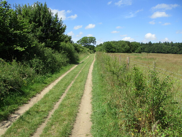
Bircham Heath is a small village located in the county of Norfolk, England. Situated on the edge of the Norfolk Downs, it is surrounded by picturesque countryside, offering residents and visitors stunning views of rolling hills and lush green fields. The village is also close to several areas of moorland, providing opportunities for outdoor activities such as hiking and birdwatching.

The village itself is characterized by its quaint and charming atmosphere, with a mix of traditional brick and thatched-roof cottages. It is home to a close-knit community, with a population of around 500 people. The village center features a few essential amenities, including a local pub and a small convenience store.

Bircham Heath is well-connected to nearby towns and cities, with the A148 road passing through the village, providing convenient access to the wider Norfolk region. The village is located approximately 10 miles from the popular coastal town of Hunstanton, known for its sandy beaches and seaside attractions.

The surrounding area offers a wealth of natural beauty, with numerous walking trails and nature reserves to explore. The Norfolk Downs, in particular, provide a haven for wildlife enthusiasts, with an abundance of rare plants and animals to discover. The nearby moorland areas also attract a variety of bird species, making it a popular destination for birdwatchers.

Overall, Bircham Heath is a charming village that offers a peaceful and idyllic setting for residents and visitors alike, with its stunning countryside views and easy access to both the Norfolk Downs and nearby moorland areas.

If you have any feedback on the listing, please let us know in the comments section below.

Bircham Heath Images

Images are sourced within 2km of 52.836509/0.62337884 or Grid Reference TF7629. Thanks to Geograph Open Source API. All images are credited.

Peddars Way and pig sties
Walking the Peddars Way
Peddars Way near Anmer
Farm track and pig sties, Bircham Heath
Prepared field and plantations near Houghton
Road through woodland near Houghton Hall
Grass field and bowl barrow, Harpley Common The bowl barrow is one of svereal in the vicinity <span class="nowrap"><a title="https://historicengland.org.uk/listing/the-list/list-entry/1010574?section=official-list-entry" rel="nofollow ugc noopener" href="https://historicengland.org.uk/listing/the-list/list-entry/1010574?section=official-list-entry">Link</a><img style="margin-left:2px;" alt="External link" title="External link - shift click to open in new window" src="https://s1.geograph.org.uk/img/external.png" width="10" height="10"/></span>
Grass field and bowl barrow, Harpley Common
The bowl barrow is one of svereal in the vicinity LinkExternal link
Peddars Way, Harpley Common
Harpley Common
Harpley Common
Woodland, Harpley Common
Bell barrow on Harpley Common One of several round barrows in the vicinity <span class="nowrap"><a title="https://historicengland.org.uk/listing/the-list/list-entry/1010577?section=official-list-entry" rel="nofollow ugc noopener" href="https://historicengland.org.uk/listing/the-list/list-entry/1010577?section=official-list-entry">Link</a><img style="margin-left:2px;" alt="External link" title="External link - shift click to open in new window" src="https://s1.geograph.org.uk/img/external.png" width="10" height="10"/></span>
Bell barrow on Harpley Common
One of several round barrows in the vicinity LinkExternal link
Peddars Way, Harpley Common
A Glimpse of Norfolk Near Anmer.
A Glimpse of Norfolk
Near Anmer.
Tumulus spotted on the Peddars Way Also see <span class="nowrap"><a title="https://en.wikipedia.org/wiki/Tumulus" rel="nofollow ugc noopener" href="https://en.wikipedia.org/wiki/Tumulus">Link</a><img style="margin-left:2px;" alt="External link" title="External link - shift click to open in new window" src="https://s1.geograph.org.uk/img/external.png" width="10" height="10"/></span>
Tumulus spotted on the Peddars Way
Also see LinkExternal link
The B1153 where it crosses the Peddars Way B roads are numbered distributor roads, which have lower traffic densities than the main trunk roads, or A roads. B roads can range from dual carriageways to single track roads with passing places. They almost always have 3- and 4-digit designations.
The B1153 where it crosses the Peddars Way
B roads are numbered distributor roads, which have lower traffic densities than the main trunk roads, or A roads. B roads can range from dual carriageways to single track roads with passing places. They almost always have 3- and 4-digit designations.
Gate to path across a field to Bunker's Hill
Approaching Bunker's Hill from the Peddars Way The Peddars Way is a long distance footpath in Norfolk. It is 46 miles long and follows the route of a Roman road. It has been suggested by more than one writer that it was not created by the Romans but was an ancient trackway, a branch or extension of the Icknield Way, used and remodelled by the Romans. The name is said to be derived from the Latin pedester – on foot.  It starts at Knettishall Heath in Suffolk (near the Norfolk-Suffolk border, about 4 miles east of Thetford), and it links with the Norfolk Coast Path at Holme-next-the-Sea.
Combined with the Norfolk Coast Path, it forms the Peddars Way & Norfolk Coast Path National Trail, one of 15 National Trails in England and Wales, and the two paths together run for 97 miles.
Wikipedia: <span class="nowrap"><a title="http://en.wikipedia.org/wiki/Peddars_Way" rel="nofollow ugc noopener" href="http://en.wikipedia.org/wiki/Peddars_Way">Link</a><img style="margin-left:2px;" alt="External link" title="External link - shift click to open in new window" src="https://s1.geograph.org.uk/img/external.png" width="10" height="10"/></span>
Approaching Bunker's Hill from the Peddars Way
The Peddars Way is a long distance footpath in Norfolk. It is 46 miles long and follows the route of a Roman road. It has been suggested by more than one writer that it was not created by the Romans but was an ancient trackway, a branch or extension of the Icknield Way, used and remodelled by the Romans. The name is said to be derived from the Latin pedester – on foot. It starts at Knettishall Heath in Suffolk (near the Norfolk-Suffolk border, about 4 miles east of Thetford), and it links with the Norfolk Coast Path at Holme-next-the-Sea. Combined with the Norfolk Coast Path, it forms the Peddars Way & Norfolk Coast Path National Trail, one of 15 National Trails in England and Wales, and the two paths together run for 97 miles. Wikipedia: LinkExternal link
Show me another place!

Bircham Heath is located at Grid Ref: TF7629 (Lat: 52.836509, Lng: 0.62337884)

Administrative County: Norfolk

District: King's Lynn and West Norfolk

Police Authority: Norfolk

What 3 Words

///across.eternity.adjusting. Near Dersingham, Norfolk

Related Wikis

Bagthorpe, Norfolk

Bagthorpe is a village and former civil parish, now in the parish of Bagthorpe with Barmer, in the King's Lynn and West Norfolk district, in the county...

Houghton Hall

Houghton Hall ( HOW-tən) is a country house in the parish of Houghton in Norfolk, England. It is the residence of David Cholmondeley, 7th Marquess of Cholmondeley...

Anmer

Anmer is a small village and civil parish in the English county of Norfolk. It is around 12 miles (19 km) north-east of the town of King's Lynn and 35...
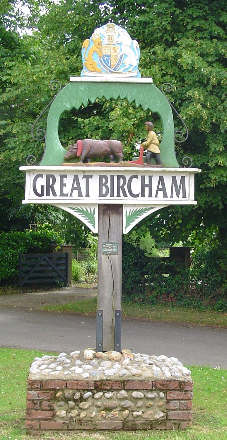
Great Bircham

Great Bircham is the largest of the three villages that make up the civil parish of Bircham, in the west of the English county of Norfolk. The village...

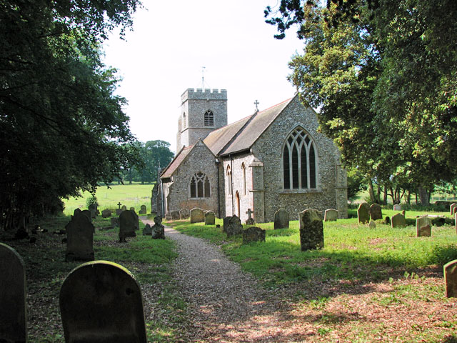
St Mary the Virgin's Church, Great Bircham

St Mary's Church, Great Bircham dates from the 12th-century, and is a Grade I listed parish church in the Church of England Diocese of Norwich in Great...

St Martin at Tours' Church, Houghton

St Martin at Tours' Church is an active Church of England parish church in the village of Houghton, Norfolk, England. It is a Grade I listed building...

Anmer Hall

Anmer Hall is a Georgian country house in the village of Anmer in Norfolk, England. Built in the 19th century, it was acquired by the Sandringham Estate...

Bircham

Bircham is a civil parish in the English county of Norfolk. It includes the three villages of Great Bircham, Bircham Newton and Bircham Tofts. The parish...

Related Videos

Bircham Windmill, North Norfolk, England

Our day trip to Bircham Windmill while on holiday in North Norfolk, England.

Nearby Amenities

Located within 500m of 52.836509,0.62337884
Barrier: kissing_gate
Bicycle: no
Foot: yes
Lat/Long: 52.8325045/0.6201967
The data included in this document is from www.openstreetmap.org. The data is made available under ODbL.

Have you been to Bircham Heath?

Leave your review of Bircham Heath below (or comments, questions and feedback).