First Ristoft Field

Downs, Moorland in Norfolk King's Lynn and West Norfolk

England

First Ristoft Field

Layby on Lynn Road, Walpole Cross Keys
Layby on Lynn Road, Walpole Cross Keys Credit: David Howard

First Ristoft Field, also known as Norfolk Downs or Moorland, is a vast expanse of open land located in Norfolk, England. Stretching over several square miles, this field is characterized by its rolling hills, meadows, and heathland, making it a picturesque and diverse natural landscape.

The field is home to a variety of plant and animal species, offering a rich biodiversity. The meadows are adorned with vibrant wildflowers, including poppies, daisies, and buttercups, while the heathland is covered with heather and gorse. This diverse vegetation attracts a wide range of wildlife, such as rabbits, hares, foxes, and various bird species, including skylarks and kestrels.

First Ristoft Field is a popular destination for nature enthusiasts, hikers, and photographers. Its undulating terrain provides stunning panoramic views of the surrounding countryside, and its peaceful atmosphere makes it an ideal spot for relaxation and contemplation. The field is crisscrossed by several footpaths and trails, allowing visitors to explore its natural beauty at their own pace.

The field also has historical significance, with remnants of ancient settlements and burial mounds scattered across its landscape. Archaeological excavations have revealed artifacts dating back thousands of years, providing valuable insights into the region's past.

First Ristoft Field is a cherished natural gem in Norfolk, offering visitors a chance to connect with nature, explore its rich history, and revel in the beauty of its diverse landscapes.

If you have any feedback on the listing, please let us know in the comments section below.

First Ristoft Field Images

Images are sourced within 2km of 52.75065/0.23706308 or Grid Reference TF5119. Thanks to Geograph Open Source API. All images are credited.

Layby on Lynn Road, Walpole Cross Keys
Lynn Road, Walpole Cross Keys
To Kings Lynn 8 Old milestone near to Walpole Cross Keys, Norfolk. For close up view see <a title="https://www.geograph.org.uk/photo/2780037" href="https://www.geograph.org.uk/photo/2780037">Link</a>
To Kings Lynn 8
Old milestone near to Walpole Cross Keys, Norfolk. For close up view see Link
Old Milestone Old milestone near to Walpole Cross Keys, Norfolk. For overall view see <a title="https://www.geograph.org.uk/photo/2780027" href="https://www.geograph.org.uk/photo/2780027">Link</a>
Old Milestone
Old milestone near to Walpole Cross Keys, Norfolk. For overall view see Link
Houses at Walpole Cross Keys Though nothing special I was struck by the height of the chimneys of these houses.
Houses at Walpole Cross Keys
Though nothing special I was struck by the height of the chimneys of these houses.
Cottages at Walpole Cross Keys Much altered and extended.
Cottages at Walpole Cross Keys
Much altered and extended.
Junction of Centenary Way and King John Bank Near the A17.
Junction of Centenary Way and King John Bank
Near the A17.
A17 at Norfolk county boundary sign
A17 south of Walpole Cross Keys
A17 at Station Road South junction
A17 eastbound nears Market Lane junction
The disused Woolpack Inn in Walpole Cross Keys Looking northward from the road.
The disused Woolpack Inn in Walpole Cross Keys
Looking northward from the road.
Ordnance Survey Flush Bracket G1503 This can be found on the wall of a private dwelling in Walpole Cross Keys.
For more detail see : <span class="nowrap"><a title="http://www.bench-marks.org.uk/bm12012" rel="nofollow ugc noopener" href="http://www.bench-marks.org.uk/bm12012">Link</a><img style="margin-left:2px;" alt="External link" title="External link - shift click to open in new window" src="https://s1.geograph.org.uk/img/external.png" width="10" height="10"/></span>
Ordnance Survey Flush Bracket G1503
This can be found on the wall of a private dwelling in Walpole Cross Keys. For more detail see : LinkExternal link
County boundary at Walpole on A17, 1956 View NW, towards Sutton Bridge (see notice-board), entering Lincolnshire (Holland) from Norfolk. The Midland & Great Northern Joint (South Lynn - Sutton Bridge section) main line ran parallel here, just to the left; the house was probably for the crossing-keeper. The modern, dual-carriage A17 was built on the former track-bed.
County boundary at Walpole on A17, 1956
View NW, towards Sutton Bridge (see notice-board), entering Lincolnshire (Holland) from Norfolk. The Midland & Great Northern Joint (South Lynn - Sutton Bridge section) main line ran parallel here, just to the left; the house was probably for the crossing-keeper. The modern, dual-carriage A17 was built on the former track-bed.
Walpole: A17 and M&GN Joint Railway, 1956 View eastward as <a href="https://www.geograph.org.uk/photo/4595395">TF5019 : County boundary at Walpole on A17, 1956</a>, towards South Lynn and King's Lynn, at the turning (left) for Wingland. The modern dual-carriageway A17 now runs along the course of the former railway (closed 3/59). My - then new - Morris Oxford is in the centre.
Walpole: A17 and M&GN Joint Railway, 1956
View eastward as TF5019 : County boundary at Walpole on A17, 1956, towards South Lynn and King's Lynn, at the turning (left) for Wingland. The modern dual-carriageway A17 now runs along the course of the former railway (closed 3/59). My - then new - Morris Oxford is in the centre.
Road junction, Grange Road, Wingland The road ahead stretches off like an arrow into Wingland Marsh. The road to the left leads up to the river bank at Sutton Bridge.
Road junction, Grange Road, Wingland
The road ahead stretches off like an arrow into Wingland Marsh. The road to the left leads up to the river bank at Sutton Bridge.
Boundary post No. 8 Marked as "BP" on the OS 1:25000 map, this post marks the boundary between Lincolnshire (on the left) and Norfolk (on the right).
Boundary post No. 8
Marked as "BP" on the OS 1:25000 map, this post marks the boundary between Lincolnshire (on the left) and Norfolk (on the right).
Drain to Cross Stiles Bank The ripples on the drain are a result of the vigorous northerly wind that was blowing all day.
Drain to Cross Stiles Bank
The ripples on the drain are a result of the vigorous northerly wind that was blowing all day.
Show me another place!

First Ristoft Field is located at Grid Ref: TF5119 (Lat: 52.75065, Lng: 0.23706308)

Administrative County: Norfolk

District: King's Lynn and West Norfolk

Police Authority: Norfolk

What 3 Words

///moss.exhaled.lamenting. Near Sutton Bridge, Lincolnshire

Related Wikis

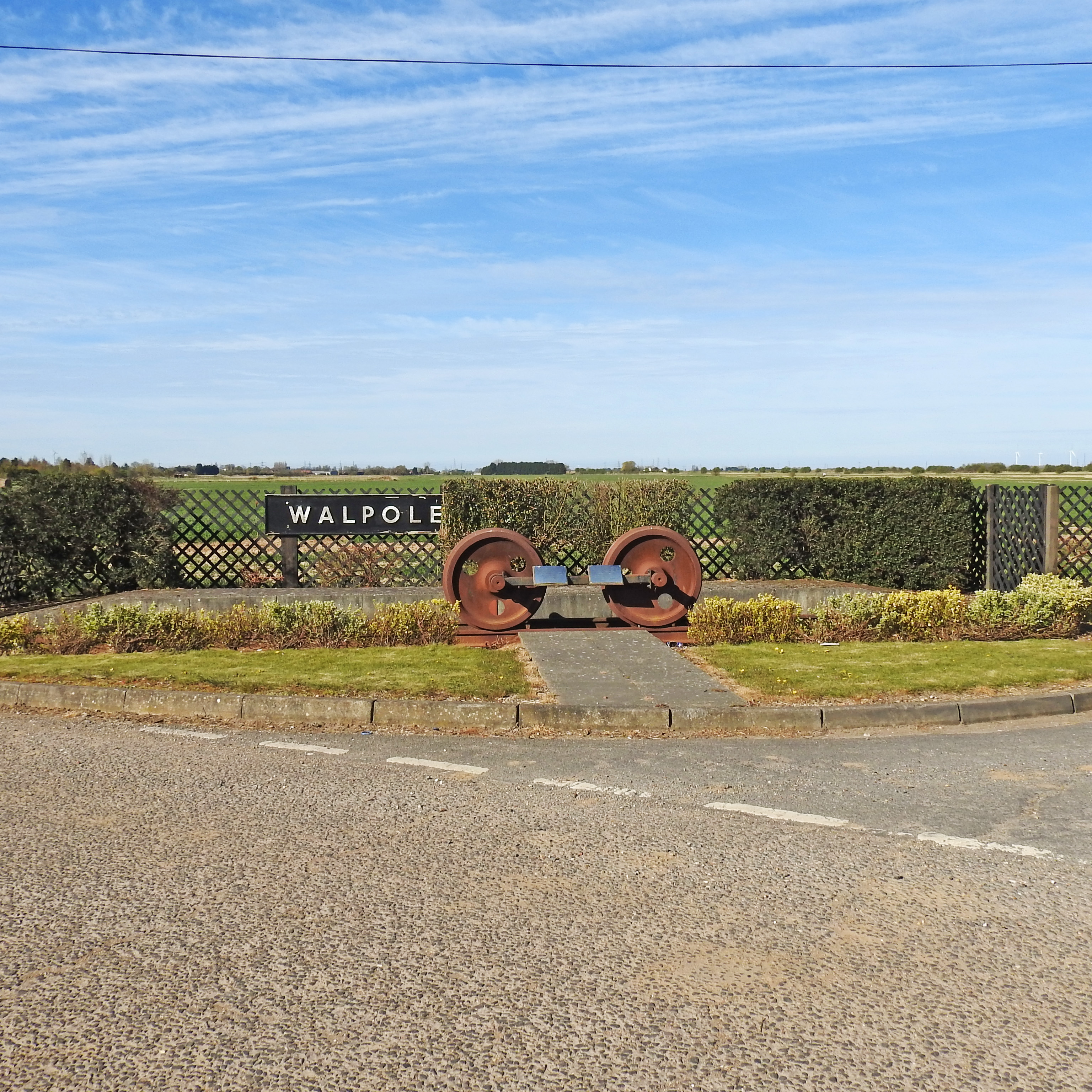
Walpole railway station (England)

Walpole railway station was a station in Norfolk. It is now disused. First opened in 1866, it was part of the Midland and Great Northern Joint Railway...

Walpole Cross Keys

Walpole Cross Keys is a village and civil parish in the English county of Norfolk. It covers an area of 4.03 km2 (1.56 sq mi) and had a population of 469...

St Andrew's Church, Walpole

St Andrew's Church is a redundant Anglican church in the village of Walpole, Norfolk, England. It is recorded in the National Heritage List for England...

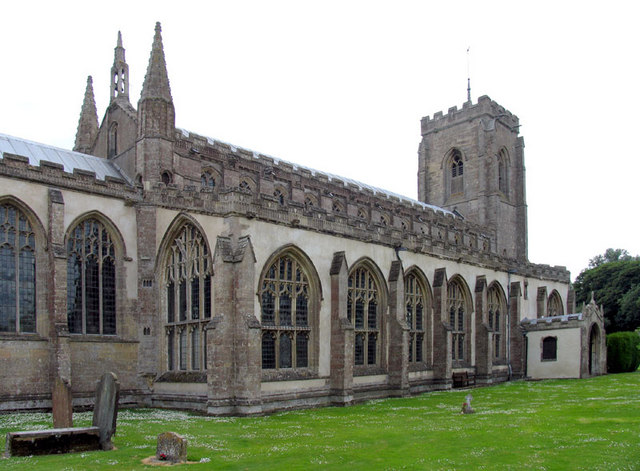
St Peter's Church, Walpole St Peter

St Peter's Church is an active Anglican parish church in Walpole St Peter, Norfolk, England. One of the largest churches in the county, it is known as...

Nearby Amenities

Located within 500m of 52.75065,0.23706308
Parking
Ele: -0.8354492
Fee: no
Parking: layby
Lat/Long: 52.7517731/0.2400652
Noexit: yes
Lat/Long: 52.7537319/0.2339261
Crown Farm
Place: farm
Lat/Long: 52.7487154/0.2342409
Walpole Road Crossing
Historic Place: locality
Lat/Long: 52.7536209/0.233924
First Ristoft Field
Place: locality
Lat/Long: 52.751543/0.2369566
Pingle Lane Crossing
Historic Railway: level_crossing
Lat/Long: 52.7517064/0.2400484
Walpole Road Crossing
Historic Railway: level_crossing
Lat/Long: 52.7536059/0.2339409
The data included in this document is from www.openstreetmap.org. The data is made available under ODbL.

Have you been to First Ristoft Field?

Leave your review of First Ristoft Field below (or comments, questions and feedback).