Millhouse Fen

Downs, Moorland in Bedfordshire

England

Millhouse Fen

John o' Gaunt pub, Sutton, Beds on the High Street.
John o' Gaunt pub, Sutton, Beds Credit: Rodney Burton

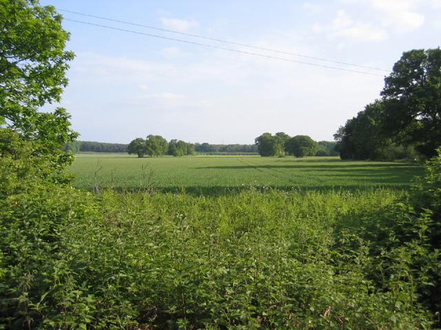
Millhouse Fen is a nature reserve located in Bedfordshire, England, known for its diverse wildlife and stunning landscapes. Situated on the outskirts of the village of Millhouse, the fen is a unique blend of downs and moorland, offering visitors a tranquil and picturesque setting to explore.

The fen is home to a variety of plant and animal species, including rare birds such as the Eurasian bittern and the marsh harrier. Visitors can also spot butterflies, dragonflies, and other insects flitting amongst the wildflowers and grasses that grow abundantly in the reserve.

The fen is crisscrossed with walking trails that meander through the marshes and wetlands, allowing visitors to immerse themselves in the natural beauty of the area. The reserve is also a popular spot for birdwatching, with several well-placed hides offering fantastic views of the birdlife that calls Millhouse Fen home.

Overall, Millhouse Fen is a must-visit destination for nature lovers and outdoor enthusiasts looking to experience the beauty and tranquility of Bedfordshire's countryside.

If you have any feedback on the listing, please let us know in the comments section below.

Millhouse Fen Images

Images are sourced within 2km of 52.113553/-0.24018684 or Grid Reference TL2047. Thanks to Geograph Open Source API. All images are credited.

John o' Gaunt pub, Sutton, Beds on the High Street.
John o' Gaunt pub, Sutton, Beds
on the High Street.
All Saints' church, Sutton, Beds situated north of Church Road, built in the Early English and Decorated styles.
All Saints' church, Sutton, Beds
situated north of Church Road, built in the Early English and Decorated styles.
Ford and bridge, Sutton, Beds A medieval twin-arched packhorse bridge over Potton Brook, a tributary of the River Ivel, where High Street meets Church Road.
Ford and bridge, Sutton, Beds
A medieval twin-arched packhorse bridge over Potton Brook, a tributary of the River Ivel, where High Street meets Church Road.
Medieval packhorse bridge, Sutton, Beds now serving as a footbridge over the Potton Brook.
Medieval packhorse bridge, Sutton, Beds
now serving as a footbridge over the Potton Brook.
High Street, Sutton, Beds
Biggleswade Road, Sutton, Beds approaching the bend on the B1040 at Watermill Bridge.
Biggleswade Road, Sutton, Beds
approaching the bend on the B1040 at Watermill Bridge.
Turnpike Farm, Sutton, Beds on the B1040 Biggleswade Road.
Turnpike Farm, Sutton, Beds
on the B1040 Biggleswade Road.
Winter wheat, Sutton, Beds on Fen Farm SW of Carthagena Road.
Winter wheat, Sutton, Beds
on Fen Farm SW of Carthagena Road.
Lupin crop, Sutton, Beds on sandy soils (Frilford series – argillic brown sands); view from Carthgena Road towards the wooded Greensand ridge.
Lupin crop, Sutton, Beds
on sandy soils (Frilford series – argillic brown sands); view from Carthgena Road towards the wooded Greensand ridge.
Entrance to bridleway, Sutton/Potton, Beds from Carthagena Road towards Galley Hill, forming the parish boundary.
Entrance to bridleway, Sutton/Potton, Beds
from Carthagena Road towards Galley Hill, forming the parish boundary.
Sandy Heath TV Transmitter Sandy Heath TV transmitter (lots of information here: <span class="nowrap"><a title="http://tx.mb21.co.uk/gallery/gallerypage.php?txid=840" rel="nofollow ugc noopener" href="http://tx.mb21.co.uk/gallery/gallerypage.php?txid=840">Link</a><img style="margin-left:2px;" alt="External link" title="External link - shift click to open in new window" src="https://s1.geograph.org.uk/img/external.png" width="10" height="10"/></span> and here <span class="nowrap"><a title="https://www.thebigtower.com/live/SandyHeath/Index.htm" rel="nofollow ugc noopener" href="https://www.thebigtower.com/live/SandyHeath/Index.htm">Link</a><img style="margin-left:2px;" alt="External link" title="External link - shift click to open in new window" src="https://s1.geograph.org.uk/img/external.png" width="10" height="10"/></span> ) with Sandy Quarry in the foreground.
Sandy Heath TV Transmitter
Sandy Heath TV transmitter (lots of information here: LinkExternal link and here LinkExternal link ) with Sandy Quarry in the foreground.
Disused sand quarry The old sand quarry workings just to the south of the Sandy Heath transmitter.
Disused sand quarry
The old sand quarry workings just to the south of the Sandy Heath transmitter.
Big foot Portobello Farm through the trees
Big foot
Portobello Farm through the trees
Bricklayers Arms, Potton
Sutton Ford and Packhorse Bridge, Bedfordshire Sutton Ford and bridge as seen from the west.
Sutton Ford and Packhorse Bridge, Bedfordshire
Sutton Ford and bridge as seen from the west.
Sutton Ford and Packhorse Bridge, Bedfordshire Sutton Ford and bridge as seen from the east.  This bridge was built in the 13th century.  It was extensively repaired by Bedfordshire Council in 1986 and is a scheduled ancient monument.
Sutton Ford and Packhorse Bridge, Bedfordshire
Sutton Ford and bridge as seen from the east. This bridge was built in the 13th century. It was extensively repaired by Bedfordshire Council in 1986 and is a scheduled ancient monument.
Sutton Ford and Packhorse Bridge, Bedfordshire Sutton Ford and bridge. This bridge was built in the 13th century. It was extensively repaired by Bedfordshire Council in 1986 and is a scheduled ancient monument.
Sutton Ford and Packhorse Bridge, Bedfordshire
Sutton Ford and bridge. This bridge was built in the 13th century. It was extensively repaired by Bedfordshire Council in 1986 and is a scheduled ancient monument.
Show me another place!

Millhouse Fen is located at Grid Ref: TL2047 (Lat: 52.113553, Lng: -0.24018684)

Unitary Authority: Central Bedfordshire

Police Authority: Bedfordshire

What 3 Words

///axed.fooling.estimated. Near Sutton, Bedfordshire

Nearby Locations

Millhouse Fen

Related Wikis

Church of All Saints, Sutton, Bedfordshire

Church of All Saints is a Grade I listed church in Sutton, Bedfordshire, England. It became a listed building on 31 October 1966. == See also == Grade...

Sutton, Bedfordshire

Sutton is a rural village and civil parish in the Central Bedfordshire district of Bedfordshire, England. It lies 11 miles (18 km) east of Bedford. At...

John O'Gaunt Golf Club

John O'Gaunt Golf Club is a golf club, located two-and-a-half miles to the north-east of Biggleswade, Bedfordshire, England, just north of the village...

Sandy Warren

Sandy Warren is a 16.4-hectare (41-acre) biological Site of Special Scientific Interest in Sandy in Bedfordshire. It is part of The Lodge, a nature reserve...

Nearby Amenities

Located within 500m of 52.113553,-0.24018684
Power: tower
Source: Bing
Lat/Long: 52.1101425/-0.2447679
The data included in this document is from www.openstreetmap.org. The data is made available under ODbL.

Have you been to Millhouse Fen?

Leave your review of Millhouse Fen below (or comments, questions and feedback).