The Green

Downs, Moorland in Lincolnshire North Kesteven

England

The Green

Church of St Andrew, Folkingham Listed Grade I; from the 12th century. The dedication, to St Andrew, is particularly common in this area (see very good information boards inside church).
Church of St Andrew, Folkingham Credit: Tim Heaton

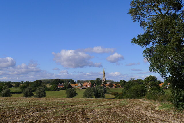
The Green is a picturesque and idyllic area located in Lincolnshire, England, known for its stunning natural landscapes and diverse ecosystems. It encompasses both downs and moorland, providing a unique blend of terrain and habitats for wildlife and outdoor enthusiasts.

The downs in The Green are characterized by their rolling hills and expansive grasslands, offering breathtaking panoramic views of the surrounding countryside. These open spaces are home to a variety of plant species, including wildflowers and grasses, creating a vibrant and colorful landscape during the warmer months. The downs also provide an important habitat for several bird species, such as skylarks and meadow pipits, making it a popular destination for birdwatching.

The moorland in The Green is a stark contrast to the downs, with its rugged terrain and heather-covered hills. This area is known for its unique flora and fauna, including rare orchids and mosses. Moorland birds, such as grouse and curlews, can also be spotted here, adding to the area's natural beauty and biodiversity.

The Green offers numerous opportunities for outdoor activities and exploration. Visitors can enjoy hiking or walking along the various trails that traverse the downs and moorland, taking in the breathtaking views and immersing themselves in nature. The area is also popular for cycling, horse riding, and picnicking.

Overall, The Green in Lincolnshire is a haven for nature lovers and outdoor enthusiasts, showcasing the region's stunning natural beauty and providing a tranquil escape from the hustle and bustle of everyday life.

If you have any feedback on the listing, please let us know in the comments section below.

The Green Images

Images are sourced within 2km of 52.901677/-0.42658355 or Grid Reference TF0534. Thanks to Geograph Open Source API. All images are credited.

Church of St Andrew, Folkingham Listed Grade I; from the 12th century. The dedication, to St Andrew, is particularly common in this area (see very good information boards inside church).
Church of St Andrew, Folkingham
Listed Grade I; from the 12th century. The dedication, to St Andrew, is particularly common in this area (see very good information boards inside church).
The Cross Britain Way leaving Folkingham Proceeding west through Folkingham's playing field
The Cross Britain Way leaving Folkingham
Proceeding west through Folkingham's playing field
The Cross Britain Way heading west over the Kesteven Uplands 'Uplands' perhaps a relative term after the Way has traversed the Fens.
The Cross Britain Way heading west over the Kesteven Uplands
'Uplands' perhaps a relative term after the Way has traversed the Fens.
Crossing a headwater tributary of the Ouse Mere Lode The Cross Britain Way between Folkingham and Pickworth
Crossing a headwater tributary of the Ouse Mere Lode
The Cross Britain Way between Folkingham and Pickworth
Church Lane between Pickworth and Walcot A quiet road
Church Lane between Pickworth and Walcot
A quiet road
Ford approaching Walcot Crossing a headwater tributary of Ouse Mere Lode
Ford approaching Walcot
Crossing a headwater tributary of Ouse Mere Lode
Road junction, Walcot A 17th century barn at Manor Farm behind the fingerpost
Road junction, Walcot
A 17th century barn at Manor Farm behind the fingerpost
Church of St Nicholas, Walcot Grade I listed.
Dating from the 12th century onwards, and restored in 1907 & 1926.
It has a 2 stage west tower with a tall crocketed broached spire from 14th Century. The tower arch is also from this period. Entered through a 17th C door in the south porch, the nave arcades are 13th C. but rest on even older bases. The font is Norman but recut in 18th C. The clerestory windows are 15th Century. The carved pew ends are 500 years old.
There is a double hagioscope. In the south aisle is a C13 trefoil headed piscina. The roof is a 14th C braced tie beam.
Church of St Nicholas, Walcot
Grade I listed. Dating from the 12th century onwards, and restored in 1907 & 1926. It has a 2 stage west tower with a tall crocketed broached spire from 14th Century. The tower arch is also from this period. Entered through a 17th C door in the south porch, the nave arcades are 13th C. but rest on even older bases. The font is Norman but recut in 18th C. The clerestory windows are 15th Century. The carved pew ends are 500 years old. There is a double hagioscope. In the south aisle is a C13 trefoil headed piscina. The roof is a 14th C braced tie beam.
The road from Walcot to Folkingham
Walcot from the south The tall, 14th century spire of St Nicholas easily visible
Walcot from the south
The tall, 14th century spire of St Nicholas easily visible
The road from Folkingham to Walcot
Village Cross, The Green, Newton Listed Grade II 'buildings': a 19th century cross and, behind, the late 18th century Laundry Cottage <span class="nowrap"><a title="https://historicengland.org.uk/listing/the-list/map-search?clearresults=true?clearresults=True#?search=TF04723626" rel="nofollow ugc noopener" href="https://historicengland.org.uk/listing/the-list/map-search?clearresults=true?clearresults=True#?search=TF04723626">Link</a><img style="margin-left:2px;" alt="External link" title="External link - shift click to open in new window" src="https://s1.geograph.org.uk/img/external.png" width="10" height="10"/></span>
Village Cross, The Green, Newton
Listed Grade II 'buildings': a 19th century cross and, behind, the late 18th century Laundry Cottage LinkExternal link
Church of St Botolph, Newton Listed Grade I. Built 13th to 15th, and restored 19th century <span class="nowrap"><a title="https://historicengland.org.uk/listing/the-list/list-entry/1061795?section=official-list-entry" rel="nofollow ugc noopener" href="https://historicengland.org.uk/listing/the-list/list-entry/1061795?section=official-list-entry">Link</a><img style="margin-left:2px;" alt="External link" title="External link - shift click to open in new window" src="https://s1.geograph.org.uk/img/external.png" width="10" height="10"/></span>
Church of St Botolph, Newton
Listed Grade I. Built 13th to 15th, and restored 19th century LinkExternal link
Restricted byway running due east from Newton Heading towards Horse Close Plantation
Restricted byway running due east from Newton
Heading towards Horse Close Plantation
Restricted byway east of Newton This pleasant cycling byway, extending 1¼ miles east from Newton, ends abruptly at Newton Gorse woodland, ahead.
Restricted byway east of Newton
This pleasant cycling byway, extending 1¼ miles east from Newton, ends abruptly at Newton Gorse woodland, ahead.
Footpath north from Newton Grange Farm The path passes Newton Gorse woodland, ahead, crosses the A52, and continues to Osbournby.
Footpath north from Newton Grange Farm
The path passes Newton Gorse woodland, ahead, crosses the A52, and continues to Osbournby.
Site of gallows by the Sleaford-Bourne road (A15) "The gallows apparently stood by the roadside where the Threekingham-Newton footpath crossed the Sleaford-Bourne road (the modern A15). The area around this site was known as Galley (from Gallows) Hill. During the early 20th century, some large stones were uncovered at this site which were interpreted as the remains of the holdfasts of the wooden gallows." <span class="nowrap"><a title="https://heritage-explorer.lincolnshire.gov.uk/Monument/MLI90643" rel="nofollow ugc noopener" href="https://heritage-explorer.lincolnshire.gov.uk/Monument/MLI90643">Link</a><img style="margin-left:2px;" alt="External link" title="External link - shift click to open in new window" src="https://s1.geograph.org.uk/img/external.png" width="10" height="10"/></span>
The site, on a road and parish boundary, was typical for gallows. The mentioned footpath, crossing the road and following the track to the right, is clearly shown on pre-1950s OS maps, but is absent on the current map.
Site of gallows by the Sleaford-Bourne road (A15)
"The gallows apparently stood by the roadside where the Threekingham-Newton footpath crossed the Sleaford-Bourne road (the modern A15). The area around this site was known as Galley (from Gallows) Hill. During the early 20th century, some large stones were uncovered at this site which were interpreted as the remains of the holdfasts of the wooden gallows." LinkExternal link The site, on a road and parish boundary, was typical for gallows. The mentioned footpath, crossing the road and following the track to the right, is clearly shown on pre-1950s OS maps, but is absent on the current map.
Walcot Bar, Sleaford Road (A15) The name suggests that there used to be a toll gate (barrier) on this former turnpike road?
Walcot Bar, Sleaford Road (A15)
The name suggests that there used to be a toll gate (barrier) on this former turnpike road?
Show me another place!

The Green is located at Grid Ref: TF0534 (Lat: 52.901677, Lng: -0.42658355)

Administrative County: Lincolnshire

District: North Kesteven

Police Authority: Lincolnshire

What 3 Words

///newspaper.flattens.silks. Near Billingborough, Lincolnshire

Related Wikis

Walcot, Lincolnshire

Walcot is a village and civil parish in the North Kesteven district of Lincolnshire, England. It lies 1 mile (1.6 km) west from the A15, 7 miles (11 km...

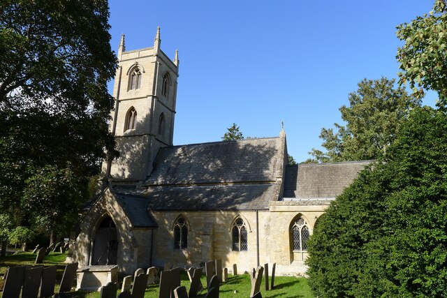
St Andrew's Church, Folkingham

The Church of St Andrew in Folkingham, Lincolnshire, England, is Grade I–listed Anglican church. Originating in the late 12th century, it was largely completed...

Newton, Lincolnshire

Newton is a hamlet in the North Kesteven district of Lincolnshire, England. The hamlet is situated approximately 8 miles (13 km) east from the town of...

Newton and Haceby

Newton and Haceby is a civil parish in North Kesteven, Lincolnshire, England. It includes the separate hamlets of Newton and Haceby. The population of...

Folkingham Castle

Folkingham Castle is located near the village of Folkingham, Lincolnshire, England. The castle was the caput baroniae of the barony of Folkingham. A motte...

Folkingham

Folkingham ( FOK-ing-əm) is a village and civil parish in the South Kesteven district of Lincolnshire, England. It lies on the A15 road 11 miles (18 km...

Threekingham Bar

Threekingham Bar is the name given to interception of the A52 (Grantham to Boston) and A15 (Peterborough to Lincoln and Hull) roads, 1 mile (1.6 km) to...

Pickworth, Lincolnshire

Pickworth is a village and civil parish in the South Kesteven district of Lincolnshire, England. The population of the civil parish including Braceby and...

Related Videos

Day 3 Macmillan Cross Britain Way Impassable Right of way Sempringham Folkingham Prison Wild camping

Filmed on the 17/08/2017 since then my video skills and equipment has improved alot :) I ended up camping in a fenced of area at ...

S01EP04 | THE REDLION PUB LINCOLNSHIRE | PARANORMAL INVESTIGATION

WELCOME TO LINCOLSHIRE PARANORMAL INVESTIGATORS IN THIS VIDEO WE DO A PARANORMAL INVESTIAGTION IN A ...

Thomas on the rings & Zoe on a swing

Thomas flip on the ring with Zoe watching on a swing.

Nearby Amenities

Located within 500m of 52.901677,-0.42658355
Walcot
Is In: Lincolnshire, England, UK
Place: hamlet
Lat/Long: 52.9031205/-0.424169
Bus Stop
The Green
Naptan AtcoCode: 270000008990
Naptan Bearing: SW
Naptan CommonName: The Green
Naptan Indicator: adj
Naptan Landmark: Telephone Box
Naptan NaptanCode: lingwmdp
Naptan Street: The Green
Naptan Verified: no
Source: naptan_import
Lat/Long: 52.9026128/-0.4258331
Bus Stop
The Green
Naptan AtcoCode: 270000008991
Naptan Bearing: NE
Naptan CommonName: The Green
Naptan Indicator: opp
Naptan Landmark: Telephone Box
Naptan NaptanCode: lingwmdt
Naptan Street: The Green
Naptan Verified: no
Source: naptan_import
Lat/Long: 52.9025804/-0.4261019
Laurel Farm
Place: farm
Source: Bing
Lat/Long: 52.9029844/-0.4229059
The Grange
Place: farm
Source: Bing
Lat/Long: 52.9031752/-0.4216985
Ford: yes
Lat/Long: 52.9002281/-0.4275792
Turning Loop
Lat/Long: 52.9030154/-0.4265125
The data included in this document is from www.openstreetmap.org. The data is made available under ODbL.

Have you been to The Green?

Leave your review of The Green below (or comments, questions and feedback).