Dunston Heath
Downs, Moorland in Lincolnshire North Kesteven
England
Dunston Heath

Dunston Heath is a picturesque area located in the county of Lincolnshire, England. It is situated on the eastern edge of the Lincolnshire Wolds, a designated Area of Outstanding Natural Beauty. The region is characterized by its rolling hills, expansive downs, and vast stretches of moorland, making it a haven for nature enthusiasts and outdoor adventurers.
Covering an area of approximately 10 square miles, Dunston Heath offers a diverse landscape that is home to a wide array of wildlife and plant species. The heathland itself is dominated by heather, gorse, and scattered birch trees, creating a unique and vibrant ecosystem. This habitat is particularly important for several bird species, including the rare stone curlew and nightjar, which can be spotted here.
The area is crisscrossed by a network of footpaths, providing ample opportunities for walking, hiking, and exploring the stunning surroundings. The tranquil ambiance and breathtaking views make Dunston Heath a popular destination for those seeking solace in nature.
The nearby villages of Dunston and Metheringham offer a range of amenities and services for visitors, including accommodation options, quaint pubs, and local shops. The region is also rich in historical and cultural heritage, with several ancient sites and landmarks scattered throughout the landscape.
Overall, Dunston Heath in Lincolnshire presents an idyllic countryside experience, with its downs, moorland, and stunning natural beauty, making it a must-visit destination for nature lovers and those seeking a peaceful retreat.
If you have any feedback on the listing, please let us know in the comments section below.
Dunston Heath Images
Images are sourced within 2km of 53.147096/-0.45399282 or Grid Reference TF0362. Thanks to Geograph Open Source API. All images are credited.


Dunston Heath is located at Grid Ref: TF0362 (Lat: 53.147096, Lng: -0.45399282)
Administrative County: Lincolnshire
District: North Kesteven
Police Authority: Lincolnshire
What 3 Words
///powers.tradition.takeovers. Near Metheringham, Lincolnshire
Nearby Locations
Related Wikis

Nocton Dairies controversy
Nocton Dairies is a British company which was formed by Devon farmer and cheese-maker Peter Willes and Lancashire milk producer David Barnes in order to...

Nocton rail crash
The Nocton rail crash was a rail accident that happened on 28 February 2002 near Nocton, Lincolnshire, England, after a vehicle smashed through a wall...

Nocton and Dunston railway station
Nocton and Dunston railway station served Nocton and Dunston in Lincolnshire which shared a GNR/GER Joint railway station until it was closed for passengers...

Lincolnshire potato railways
The Lincolnshire potato railways were a network of private, 1 ft 11+1⁄2 in (597 mm) narrow gauge farm railways which existed in the English county of Lincolnshire...
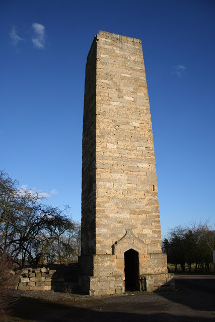
Dunston Pillar
Dunston Pillar is a Grade II listed stone tower in Lincolnshire, England and a former 'land lighthouse'. It stands beside the A15 road approximately 6...

Dunston, Lincolnshire
Dunston is a small village in the North Kesteven district of Lincolnshire, England. It is situated approximately 7 miles (11 km) south-east from the city...
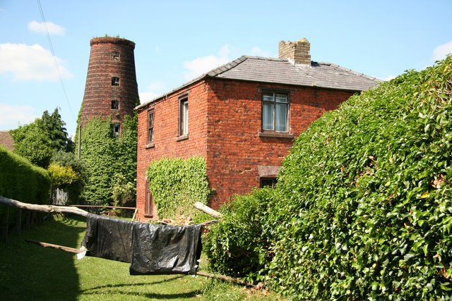
Metheringham Windmill
Metheringham Windmill, locally known as The Old Meg Flour Mill, was a six-storeyed, six-sailed, and tarred slender Lincolnshire type windmill with the...

Nocton
Nocton is a village and civil parish in the North Kesteven district of Lincolnshire, England. It is situated on the B1202 road, 7 miles (11 km) south-east...
Nearby Amenities
Located within 500m of 53.147096,-0.45399282Have you been to Dunston Heath?
Leave your review of Dunston Heath below (or comments, questions and feedback).