Abbey Moors

Downs, Moorland in Yorkshire Harrogate

England

Abbey Moors

Wilstrop Level Crossing
Wilstrop Level Crossing Credit: Roger W Haworth

Abbey Moors, located in Yorkshire, England, is a picturesque region characterized by its stunning landscapes and rich history. Spanning across both downs and moorland, this area offers a diverse range of natural and cultural attractions.

The downs of Abbey Moors are characterized by their rolling hills, lush green meadows, and scenic vistas. These open expanses are perfect for leisurely walks and picnics, offering visitors a chance to immerse themselves in the tranquil beauty of the countryside. The downs are also home to a variety of wildlife, including rare bird species, making it a popular spot for birdwatching enthusiasts.

In contrast, the moorland of Abbey Moors presents a more rugged and untamed environment. Here, visitors can explore vast stretches of heather-clad hills, rocky outcrops, and winding trails. The moorland is known for its unique ecosystem, supporting a range of plant and animal species specially adapted to this distinct habitat. It is also steeped in history, with ancient stone circles and burial sites dotting the landscape.

Abbey Moors is not only renowned for its natural beauty but also its historical significance. The region is home to several ancient abbeys and monastic ruins, providing a glimpse into its medieval past. Visitors can explore these fascinating architectural remnants, such as the ruins of Rievaulx Abbey, which was once one of the wealthiest monasteries in England.

Overall, Abbey Moors in Yorkshire offers a captivating blend of stunning downs, rugged moorland, and historical landmarks. Whether seeking tranquility in nature or delving into the area's rich heritage, this region promises an unforgettable experience for visitors.

If you have any feedback on the listing, please let us know in the comments section below.

Abbey Moors Images

Images are sourced within 2km of 53.993619/-1.2253865 or Grid Reference SE5055. Thanks to Geograph Open Source API. All images are credited.
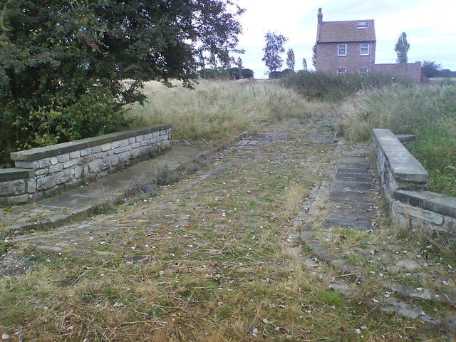
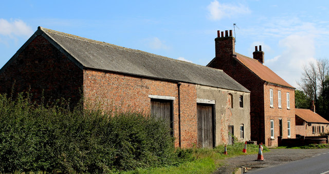
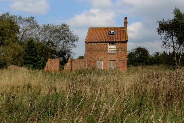
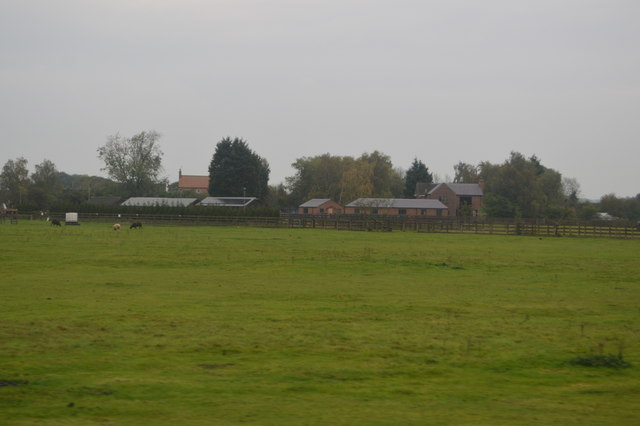
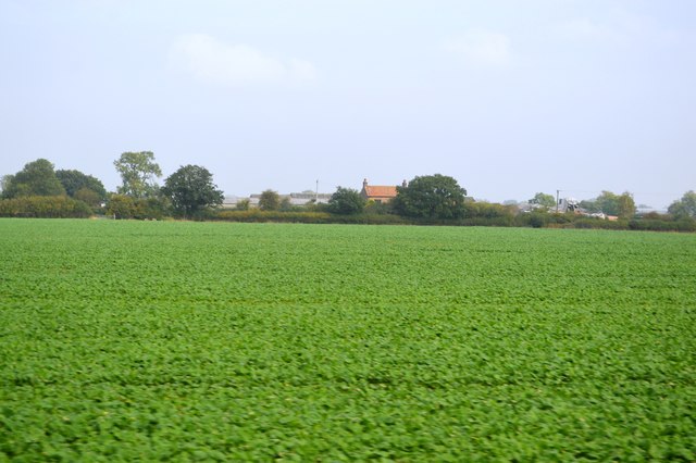
Wilstrop Level Crossing
Flooded section of Wilstop Lane Just off the A59 York Road.
Flooded section of Wilstop Lane
Just off the A59 York Road.
Trotters Farm Aptly named Pig Farm by the A59 York to Harrogate road.
Trotters Farm
Aptly named Pig Farm by the A59 York to Harrogate road.
Smart bridge and derelict house Residing in an overgrown field close to Trotters Farm this smart bridge forms part of the footpath from Wilstrop Lodge Farm.
Smart bridge and derelict house
Residing in an overgrown field close to Trotters Farm this smart bridge forms part of the footpath from Wilstrop Lodge Farm.
Track to Wilstrop Lodge Farm The helpful notice attached to the tree announces that this is a 'designated pig slurry and muck disposal area'. Best to hold your nose if walking through. The track is also a public footpath.
Track to Wilstrop Lodge Farm
The helpful notice attached to the tree announces that this is a 'designated pig slurry and muck disposal area'. Best to hold your nose if walking through. The track is also a public footpath.
Wilstrop Lodge Farm The title of 'farm' no longer applies as the run down buildings have been rebuilt and added to, and are now for sale as 'desirable country residences and barn conversions'. However, potential buyers might be put off by the sign on the approach road [see other photo in this square].
Wilstrop Lodge Farm
The title of 'farm' no longer applies as the run down buildings have been rebuilt and added to, and are now for sale as 'desirable country residences and barn conversions'. However, potential buyers might be put off by the sign on the approach road [see other photo in this square].
Skip Bridge Inn Farm Farming operation on the A59 Harrogate/York Road
Skip Bridge Inn Farm
Farming operation on the A59 Harrogate/York Road
Footpath heading North East from Skip Bridge Inn Farm Public footpath heading towards Moor Monkton
Footpath heading North East from Skip Bridge Inn Farm
Public footpath heading towards Moor Monkton
Public Footpath heading for Moor Monkton The footpath is not visible on the ground, but follows the fence on its journey between Skip Bridge and Moor Monkton.
Public Footpath heading for Moor Monkton
The footpath is not visible on the ground, but follows the fence on its journey between Skip Bridge and Moor Monkton.
Abandoned House near Trotters Farm Standing alone in an uncultivated field, dominated by thistles and with no apparent means of access, save a footpath.
Abandoned House near Trotters Farm
Standing alone in an uncultivated field, dominated by thistles and with no apparent means of access, save a footpath.
Single Track Railway between York and Harrogate
Access Lane from Wilstrop Lodge Farm Leading towards the lane at White Sike Bridge
Access Lane from Wilstrop Lodge Farm
Leading towards the lane at White Sike Bridge
Approaching Wilstrop Lodge Farm A public footpath has adopted the access drive leading into Wilstrop Lodge Farm - and continuing northwards utilises the garden to reach fields beyond.
Approaching Wilstrop Lodge Farm
A public footpath has adopted the access drive leading into Wilstrop Lodge Farm - and continuing northwards utilises the garden to reach fields beyond.
Skip Bridge Farm
Skip Bridge Farm
Field of crops
Field of crops
Rough grassland
Rough grassland
Trotters Farm
Trotters Farm
Show me another place!

Abbey Moors is located at Grid Ref: SE5055 (Lat: 53.993619, Lng: -1.2253865)

Division: West Riding

Administrative County: North Yorkshire

District: Harrogate

Police Authority: North Yorkshire

What 3 Words

///committed.embodied.moods. Near Nether Poppleton, North Yorkshire

Related Wikis

All Saints' Church, Moor Monkton

All Saints' Church is the parish church of Moor Monkton, a village north-west of York in England. The church dates from the 12th century, when the nave...

Marston Moor railway station

Marston Moor railway station served the village of Long Marston, North Yorkshire, England from 1848 to 1967 on the Harrogate line. == History == The station...

Moor Monkton

Moor Monkton is a village and civil parish in the former Harrogate District of North Yorkshire, England. It is situated on the River Nidd and 7 miles...

Wilstrop Siding railway station

Wilstrop railway station served Wilstrop and Skipbridge, North Yorkshire, England from 1865 to 1964 on the Harrogate line. == History == The station opened...

Wilstrop

Wilstrop is a civil parish about 8 miles (13 km) west of York, in the Harrogate district, in the county of North Yorkshire, England. In 2001 the parish...

Hessay railway station

Hessay railway station served the village of Hessay, North Yorkshire, England from 1849 to 1964 on the Harrogate line. == History == The station opened...

Nun Monkton

Nun Monkton is a village and civil parish in the Harrogate district of North Yorkshire, England. It is situated 8 miles (13 km) northwest of York at the...

River Nidd

The River Nidd is a tributary of the River Ouse in the English county of North Yorkshire. In its first few miles it is dammed three times to create Angram...

Nearby Amenities

Located within 500m of 53.993619,-1.2253865
Power: tower
Source: Bing
Lat/Long: 53.9938277/-1.2229282
Power: tower
Source: Bing
Lat/Long: 53.9912228/-1.2243536
Power: tower
Source: Bing
Lat/Long: 53.9963348/-1.2215369
Power: pole
Lat/Long: 53.9933653/-1.2188042
Line Management: branch
Material: wood
Power: pole
Lat/Long: 53.9933916/-1.2195129
Location Transition: yes
Material: wood
Power: pole
Switch: mechanical
Lat/Long: 53.9934094/-1.2198304
Location Transition: yes
Power: tower
Lat/Long: 53.993994/-1.219904
Material: wood
Power: tower
Transformer: distribution
Lat/Long: 53.9940233/-1.2199259
Location Transition: yes
Power: pole
Lat/Long: 53.99375/-1.2241044
Line Management: branch
Power: pole
Lat/Long: 53.9938804/-1.2249854
Power: pole
Lat/Long: 53.9941009/-1.2262003
Power: pole
Lat/Long: 53.9943155/-1.2275312
Power: pole
Lat/Long: 53.9945389/-1.2288446
Line Management: branch
Power: pole
Lat/Long: 53.9949543/-1.2300471
Power: pole
Lat/Long: 53.9944664/-1.2306693
Power: pole
Lat/Long: 53.9938224/-1.2314521
Power: pole
Lat/Long: 53.9932657/-1.2321313
Power: pole
Lat/Long: 53.9926994/-1.2328074
Power: pole
Lat/Long: 53.9905328/-1.2299081
Power: pole
Lat/Long: 53.9949841/-1.2241628
Power: pole
Lat/Long: 53.9957591/-1.2235768
Power: pole
Lat/Long: 53.996508/-1.2230272
Power: pole
Transformer: distribution
Lat/Long: 53.9971752/-1.2225428
Power: pole
Lat/Long: 53.9953936/-1.231282
The data included in this document is from www.openstreetmap.org. The data is made available under ODbL.

Have you been to Abbey Moors?

Leave your review of Abbey Moors below (or comments, questions and feedback).