Middlesbrough Osmotherley Moor

Downs, Moorland in Yorkshire Hambleton

England

Middlesbrough Osmotherley Moor

Moorland pond Rush fringed pond at the moorland edge. Smoke from heather burning rises in the distance.
Moorland pond Credit: Gordon Hatton

Middlesbrough Osmotherley Moor is a picturesque area located in Yorkshire, England. It forms a part of the beautiful North York Moors National Park, renowned for its stunning landscapes and diverse wildlife. This moorland is situated near the small village of Osmotherley and is easily accessible from Middlesbrough, which is approximately 20 miles away.

The moorland features rolling hills, vast open spaces, and heather-covered landscapes that stretch as far as the eye can see. It offers breathtaking views of the surrounding countryside and provides a tranquil escape for nature enthusiasts and hikers alike. The area is crisscrossed with well-marked trails and footpaths, making it an ideal destination for walkers and cyclists.

The wildlife on Osmotherley Moor is abundant, with sightings of various bird species, including curlews, lapwings, and red grouse, being common. The moorland is also home to other wildlife such as hares, deer, and even the occasional adder snake. The diverse flora and fauna of the area are protected and preserved by the national park authorities.

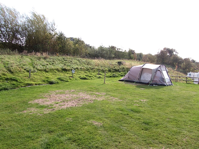
Visitors to Middlesbrough Osmotherley Moor can enjoy a range of recreational activities, including picnicking, birdwatching, and photography. The moorland is also a popular spot for nature study and conservation research. Additionally, there are designated camping areas and campsites for those who wish to spend more time exploring the beauty of the moorland.

Overall, Middlesbrough Osmotherley Moor offers a serene and picturesque escape from the hustle and bustle of everyday life. Its natural beauty, coupled with its accessibility and recreational opportunities, makes it a prime destination for nature lovers and outdoor enthusiasts.

If you have any feedback on the listing, please let us know in the comments section below.

Middlesbrough Osmotherley Moor Images

Images are sourced within 2km of 54.362368/-1.2724073 or Grid Reference SE4796. Thanks to Geograph Open Source API. All images are credited.

Moorland pond Rush fringed pond at the moorland edge. Smoke from heather burning rises in the distance.
Moorland pond
Rush fringed pond at the moorland edge. Smoke from heather burning rises in the distance.
Moorland track, Whitestones Ridge Shooting track on access land at the head of Ryedale. Smoke from controlled heather burning in the distance.
Moorland track, Whitestones Ridge
Shooting track on access land at the head of Ryedale. Smoke from controlled heather burning in the distance.
West End, Osmotherley in 1984 My Renault 4GTL is seen parked outside The Golden Lion public house
West End, Osmotherley in 1984
My Renault 4GTL is seen parked outside The Golden Lion public house
North End, Osmotherley An uphill view past a cafe.
North End, Osmotherley
An uphill view past a cafe.
Cote Ghyll camp site Camp sites are incredibly rare in the North York Moors. This one was completely full, this pitch being taken soon after the photograph was.
Cote Ghyll camp site
Camp sites are incredibly rare in the North York Moors. This one was completely full, this pitch being taken soon after the photograph was.
Cote Ghyll Caravan & Camping Park One of the infrequent caravan sites in the North York Moors.  The sector seems dominated by the clubs which is no use to infrequent visitors to England.
This site is very good with excellent facilities.
Cote Ghyll Caravan & Camping Park
One of the infrequent caravan sites in the North York Moors. The sector seems dominated by the clubs which is no use to infrequent visitors to England. This site is very good with excellent facilities.
Leystone Ridge A slight rise on Osmotherley Moor.
Leystone Ridge
A slight rise on Osmotherley Moor.
Osmotherley Moor A boulder breaks up the flat moorland landscape.
Osmotherley Moor
A boulder breaks up the flat moorland landscape.
Miley Pike Hill A gentle rise on Osmotherley Moor.
Miley Pike Hill
A gentle rise on Osmotherley Moor.
Road, Osmotherley Moor An estate road on Miley Pike Hill.
Road, Osmotherley Moor
An estate road on Miley Pike Hill.
Whitestones Ridge A moorland road above Osmotherley.
Whitestones Ridge
A moorland road above Osmotherley.
Miley Pike Hill A moorland road crossing Osmotherley and Whorlton Moor.
Miley Pike Hill
A moorland road crossing Osmotherley and Whorlton Moor.
Moorland road, Whitestones Ridge A view of Black Hambleton.
Moorland road, Whitestones Ridge
A view of Black Hambleton.
Moorland, Whitestones Ridge
Pond, Whitestones Ridge A roadside pond, set in a vast acreage of heather.
Pond, Whitestones Ridge
A roadside pond, set in a vast acreage of heather.
Osmotherley - Ryedale road, Robinson's Cross A minor road over the Hambleton Hills.
Osmotherley - Ryedale road, Robinson's Cross
A minor road over the Hambleton Hills.
Hambleton Street An unsurfaced hill road leads towards Black Hambleton.
Hambleton Street
An unsurfaced hill road leads towards Black Hambleton.
Path, Square Corner Square Corner is a right angled bend in the road over the Hambleton Hills from Osmotherley. It is also in the corner of a grid square.  The well surfaced path carries the Cleveland Way down to Osmotherley.
The signpost has lost its arms. <a href="https://www.geograph.org.uk/photo/1746999">SE4795 : High or low?</a>
Path, Square Corner
Square Corner is a right angled bend in the road over the Hambleton Hills from Osmotherley. It is also in the corner of a grid square. The well surfaced path carries the Cleveland Way down to Osmotherley. The signpost has lost its arms. SE4795 : High or low?
Show me another place!

Middlesbrough Osmotherley Moor is located at Grid Ref: SE4796 (Lat: 54.362368, Lng: -1.2724073)

Division: North Riding

Administrative County: North Yorkshire

District: Hambleton

Police Authority: North Yorkshire

What 3 Words

///contracts.meaty.lasts. Near Brompton, North Yorkshire

Related Wikis

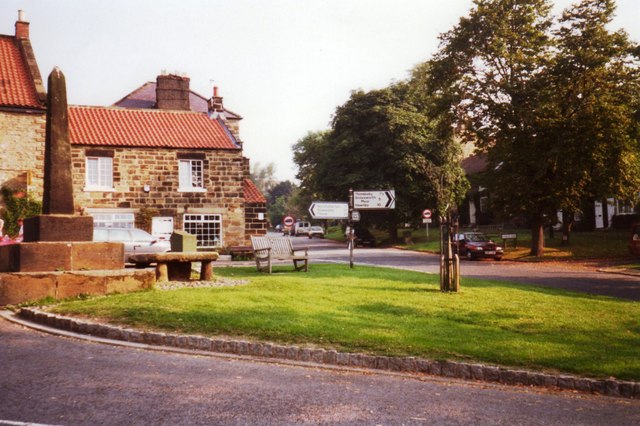
Osmotherley, North Yorkshire

Osmotherley is a village and civil parish in the Hambleton hills in North Yorkshire, six miles north-east of Northallerton. The village is at the western...

Osmotherley Friends Meeting House

Osmotherley Friends Meeting House is a Friends Meeting House of the Religious Society of Friends (Quakers), situated in the village of Osmotherley in North...

Cod Beck Reservoir

Cod Beck Reservoir is a man-made lake situated within the North York Moors National Park and near the village of Osmotherley in the English county of North...

Thimbleby, North Yorkshire

Thimbleby is a small village and civil parish in the Hambleton District of North Yorkshire, England, it is in the North Yorks Moors and close to the village...

Nearby Amenities

Located within 500m of 54.362368,-1.2724073
The Chequers
Tourism: guest_house
Lat/Long: 54.3666027/-1.2701319
Fixme: As of October 2019, there's more water in than this. Needs another survey
Lat/Long: 54.3586162/-1.2738336
Information: route_marker
Tourism: information
Lat/Long: 54.35849/-1.2713467
Fixme: Needs resurvey to confirm path and stream alignment here
Lat/Long: 54.3584901/-1.2713887
Ford: yes
Source: survey
Lat/Long: 54.3613639/-1.2649635
The data included in this document is from www.openstreetmap.org. The data is made available under ODbL.

Have you been to Middlesbrough Osmotherley Moor?

Leave your review of Middlesbrough Osmotherley Moor below (or comments, questions and feedback).