West Field

Downs, Moorland in Yorkshire

England

West Field

Perching gulls Beside the lake in Anglers Country Park.
Perching gulls Credit: Graham Hogg

West Field is a region located in Yorkshire, England, known for its diverse landscape encompassing downs and moorland. Situated in the western part of Yorkshire, West Field is characterized by its rolling hills, open grasslands, and vast stretches of heather-covered moorland.

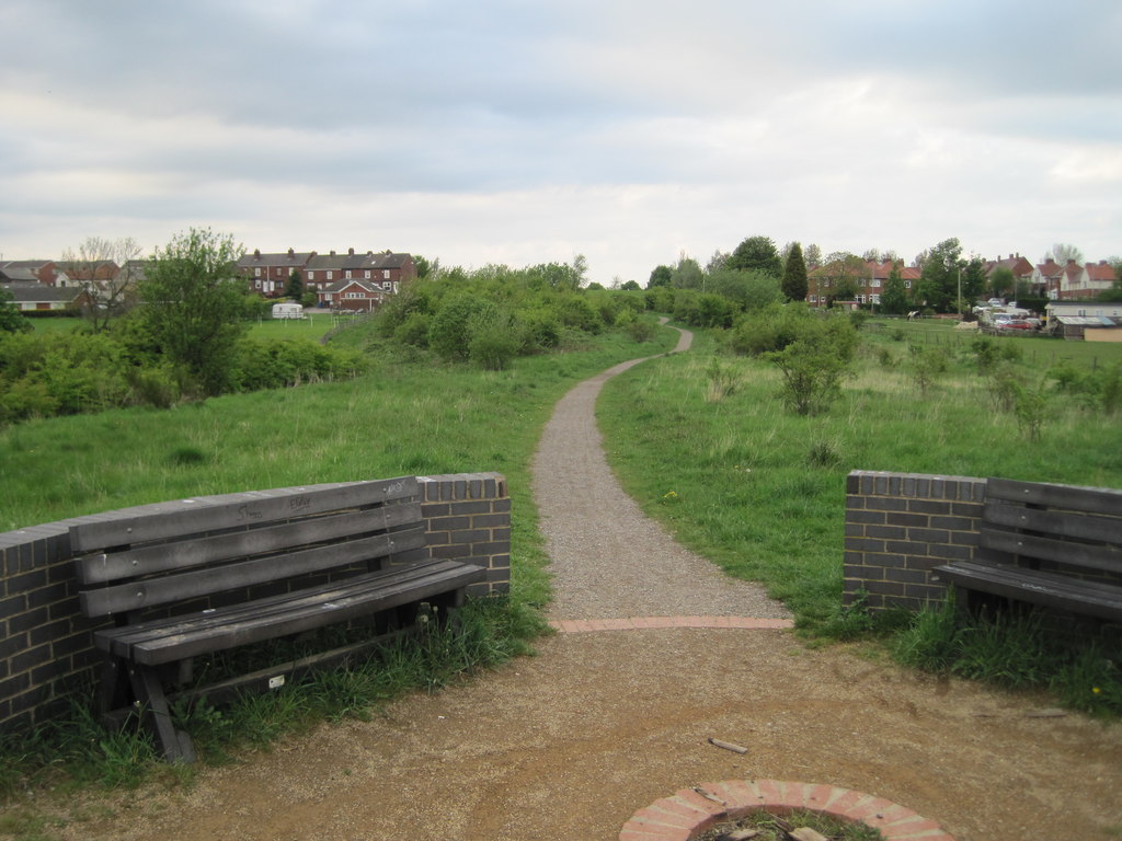
The downs in West Field feature gentle slopes and offer stunning panoramic views of the surrounding countryside. The landscape is dotted with small villages and scattered farmhouses, adding to the charm and tranquility of the area. The downs are known for their rich biodiversity, with a variety of plant species, including wildflowers and grasses, thriving in this unique environment.

Moving towards the moorland, the terrain becomes more rugged and wild. The moors, covered in a vibrant purple hue during the flowering season, are home to an array of wildlife, including grouse, curlew, and various bird species. The moorland is crisscrossed with streams and rivers, which not only contribute to the beauty of the landscape but also provide a habitat for aquatic animals and plants.

West Field is a popular destination for outdoor enthusiasts, offering ample opportunities for hiking, birdwatching, and photography. The region's vast open spaces and unspoiled nature make it an ideal location for those seeking solitude and a chance to immerse themselves in the beauty of the Yorkshire countryside.

In conclusion, West Field in Yorkshire, with its downs and moorland, provides a picturesque setting for nature lovers and adventurers alike. Its varied landscape, abundant wildlife, and serene atmosphere make it a captivating destination for anyone seeking a connection with nature.

If you have any feedback on the listing, please let us know in the comments section below.

West Field Images

Images are sourced within 2km of 53.619865/-1.4269799 or Grid Reference SE3813. Thanks to Geograph Open Source API. All images are credited.

Perching gulls Beside the lake in Anglers Country Park.
Perching gulls
Beside the lake in Anglers Country Park.
Peak & Northern Footpaths Society sign #364 One of several signs erected by the society on footpaths around Anglers Country Park. For detail see <a href="https://www.geograph.org.uk/photo/6923282">SE3715 : Peak & Northern Footpaths Society sign #364</a>]
Peak & Northern Footpaths Society sign #364
One of several signs erected by the society on footpaths around Anglers Country Park. For detail see SE3715 : Peak & Northern Footpaths Society sign #364]
Peak & Northern Footpaths Society sign #364 One of several signs erected by the society on footpaths around Anglers Country Park.
Peak & Northern Footpaths Society sign #364
One of several signs erected by the society on footpaths around Anglers Country Park.
Peak & Northern Footpaths Society sign #363 One of several signs erected by the society on footpaths around Anglers Country Park.
Peak & Northern Footpaths Society sign #363
One of several signs erected by the society on footpaths around Anglers Country Park.
Cold Hiendley Reservoir Looking west from the Wintersett Reservoir dam wall. The reservoir was built to serve the long abandoned Barnsley Canal.
Cold Hiendley Reservoir
Looking west from the Wintersett Reservoir dam wall. The reservoir was built to serve the long abandoned Barnsley Canal.
Wintersett Reservoir The reservoir was built to serve the long abandoned Barnsley Canal. It is now used mainly for leisure activities.
Wintersett Reservoir
The reservoir was built to serve the long abandoned Barnsley Canal. It is now used mainly for leisure activities.
Wintersett Reservoir The reservoir was built to serve the long abandoned Barnsley Canal. It is now used mainly for leisure activities.
Wintersett Reservoir
The reservoir was built to serve the long abandoned Barnsley Canal. It is now used mainly for leisure activities.
Wooden mushrooms beside the lake at Anglers Country Park The country park was created in 1986 on the site of one of the UK's deepest open cast coal mines.
Wooden mushrooms beside the lake at Anglers Country Park
The country park was created in 1986 on the site of one of the UK's deepest open cast coal mines.
Trees along a field boundary, south of Haw Park This field boundary is shown on the large-scale OS map surveyed in 1849-51, but without trees.
Trees along a field boundary, south of Haw Park
This field boundary is shown on the large-scale OS map surveyed in 1849-51, but without trees.
Location map, Haw Park Wood One of several along the complex network of paths.
Location map, Haw Park Wood
One of several along the complex network of paths.
Entrance to the Wild Wood A pet cemetery between Haw Park Wood and Anglers Country Park.
Entrance to the Wild Wood
A pet cemetery between Haw Park Wood and Anglers Country Park.
The Wild Wood, south of Haw Park Wood A pet cemetery between Haw Park Wood and Anglers Country Park.
The Wild Wood, south of Haw Park Wood
A pet cemetery between Haw Park Wood and Anglers Country Park.
Arable land, Felkirk
Junction on the Trans-Pennine Trail, Walton
Bridleway to Haw Park, Walton This used to be woodland over a hundred years ago.
Bridleway to Haw Park, Walton
This used to be woodland over a hundred years ago.
Entrance to Wild Wood memorial woodland, Walton In here clients are able to scatter the ashes of their pets and, if they wish, erect a memorial plaque.
Entrance to Wild Wood memorial woodland, Walton
In here clients are able to scatter the ashes of their pets and, if they wish, erect a memorial plaque.
Haw Park Lane approaching a barrier, Wintersett Hoping I have remembered correctly the lane ends at the barrier and a bridleway continues to Haw Park and Walton.
Haw Park Lane approaching a barrier, Wintersett
Hoping I have remembered correctly the lane ends at the barrier and a bridleway continues to Haw Park and Walton.
Haw Park Lane, Wintersett
Show me another place!

West Field is located at Grid Ref: SE3813 (Lat: 53.619865, Lng: -1.4269799)

Division: West Riding

Unitary Authority: Wakefield

Police Authority: West Yorkshire

What 3 Words

///stars.egging.applauded. Near Ryhill, West Yorkshire

Related Wikis

Ryhill railway station

Ryhill railway station was situated on the Barnsley Coal Railway, later the MS&L, Great Central and London and North Eastern Railway. == History == The...

Ryhill Halt railway station

Ryhill Halt railway station in Ryhill, West Yorkshire, England was a small railway halt on the Dearne Valley Junction Railway, a branch of the Lancashire...
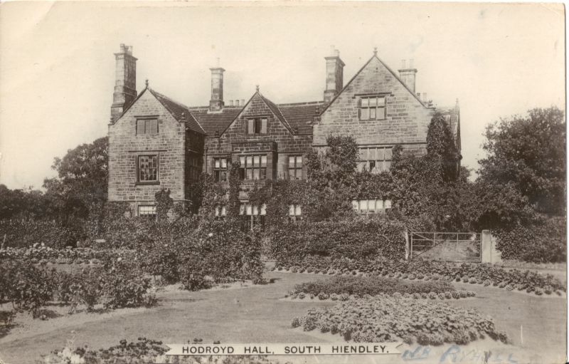
Hodroyd Hall

Hodroyd Hall at South Hiendley in the parish of Felkirk near Barnsley in West Yorkshire, England is an Elizabethan manor house currently used as 3 dwellings...
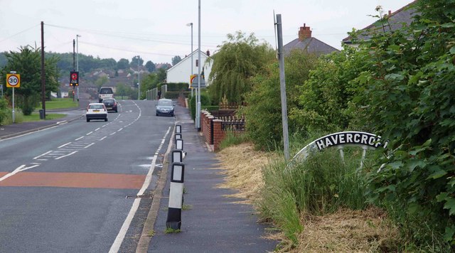
Havercroft

Havercroft is a small village situated on the B6428 in West Yorkshire, England, approximately 7 miles (11 km) south-east of the city of Wakefield. It forms...

Nearby Amenities

Located within 500m of 53.619865,-1.4269799
Power: pole
Lat/Long: 53.6156919/-1.429422
Power: pole
Lat/Long: 53.616605/-1.430712
Power: pole
Lat/Long: 53.6177454/-1.432325
Power: pole
Lat/Long: 53.6190601/-1.4322312
Power: pole
Lat/Long: 53.6199735/-1.4308558
Power: pole
Lat/Long: 53.62084/-1.429465
Power: pole
Lat/Long: 53.621431/-1.4285905
Power: pole
Lat/Long: 53.6224683/-1.4276097
Power: pole
Lat/Long: 53.6233043/-1.425424
Ryhill
Historic Railway: station
Railway: site
Wikidata: Q7385062
Wikipedia: en:Ryhill railway station
Lat/Long: 53.623396/-1.4255528
The data included in this document is from www.openstreetmap.org. The data is made available under ODbL.

Have you been to West Field?

Leave your review of West Field below (or comments, questions and feedback).