High Common

Downs, Moorland in Yorkshire Harrogate

England

High Common

Marton le Moor, 18 Whitegate The benchmark is cut into the south-east face of the property.
Marton le Moor, 18 Whitegate Credit: Mel Towler

High Common is a picturesque region situated in Yorkshire, England, encompassing both the Downs and Moorland landscapes. With its breathtaking natural beauty and diverse ecosystems, it attracts visitors from far and wide.

The Downs in High Common are characterized by their gently rolling hills, lush grasslands, and scattered woodlands. This area is known for its rich biodiversity, supporting a variety of plant and animal species. It provides a perfect habitat for various birds, including skylarks and meadow pipits, as well as small mammals like hares and rabbits. The Downs offer stunning panoramic views, making it a popular destination for hikers, nature enthusiasts, and photographers.

Adjacent to the Downs, the Moorland of High Common presents a stark contrast with its rugged terrain, heather-covered hills, and vast expanses of open space. This unique landscape is home to rare flora and fauna, such as bilberries and the elusive golden plover. The Moorland also boasts ancient archaeological sites, including stone circles and burial mounds, which provide a glimpse into the area's rich history.

High Common benefits from a temperate climate, with mild summers and cool winters. The region experiences frequent rainfall, which contributes to its lush greenery and vibrant flora. Local communities in High Common have embraced sustainable practices, preserving the area's natural resources and promoting eco-tourism.

Overall, High Common offers visitors a harmonious blend of natural beauty, cultural heritage, and outdoor activities, making it an ideal destination for those seeking tranquility and a connection with nature.

If you have any feedback on the listing, please let us know in the comments section below.

High Common Images

Images are sourced within 2km of 54.116081/-1.4305328 or Grid Reference SE3769. Thanks to Geograph Open Source API. All images are credited.

Marton le Moor, 18 Whitegate The benchmark is cut into the south-east face of the property.
Marton le Moor, 18 Whitegate
The benchmark is cut into the south-east face of the property.
Marton le Moor, 18 Whitegate There is a benchmark cut into the south-east face of the property. The gnomes are keeping it company.
Marton le Moor, 18 Whitegate
There is a benchmark cut into the south-east face of the property. The gnomes are keeping it company.
Marton le Moor, The Balk According to the OS benchmark database there was a benchmark cut into a wooden gatepost at this location. Today there is no field entrance and gateposts, although the hedge is thinner indicating a previous access point to the field.
Marton le Moor, The Balk
According to the OS benchmark database there was a benchmark cut into a wooden gatepost at this location. Today there is no field entrance and gateposts, although the hedge is thinner indicating a previous access point to the field.
Moor Lane Three roads run parallel to each other in this area. This is definitely the quietest.
Moor Lane
Three roads run parallel to each other in this area. This is definitely the quietest.
Skelton, Pasture Lane, Low Moor House The benchmark is cut into the gable end of a stone agricultural building and is to the left of a drainpipe. The cutmark is damaged.
Skelton, Pasture Lane, Low Moor House
The benchmark is cut into the gable end of a stone agricultural building and is to the left of a drainpipe. The cutmark is damaged.
Skelton, Pasture Lane, Low Moor House There is a benchmark cut into the gable end of the stone agricultural building and is to the left of the furthest left green drainpipe. The cutmark is damaged.
Skelton, Pasture Lane, Low Moor House
There is a benchmark cut into the gable end of the stone agricultural building and is to the left of the furthest left green drainpipe. The cutmark is damaged.
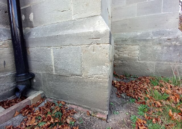
Skelton on Ure, old agricultural barn The benchmark is cut into the left cornerstones of this old farm building situated on the edge of the village.
Skelton on Ure, old agricultural barn
The benchmark is cut into the left cornerstones of this old farm building situated on the edge of the village.
Skelton on Ure, old agricultural building There is a benchmark cut into the left cornerstones of this old farm building which is situated on the edge of the village and road junction.
Skelton on Ure, old agricultural building
There is a benchmark cut into the left cornerstones of this old farm building which is situated on the edge of the village and road junction.
Skelton on Ure, converted Methodist church The OS Flush Bracket S6737 is embedded in the south facing wall of the converted Methodist church.
Skelton on Ure, converted Methodist church
The OS Flush Bracket S6737 is embedded in the south facing wall of the converted Methodist church.
Skelton on Ure, converted Methodist church There is OS Flush Bracket S6737 embedded into the south facing wall of the converted Methodist church.
Skelton on Ure, converted Methodist church
There is OS Flush Bracket S6737 embedded into the south facing wall of the converted Methodist church.
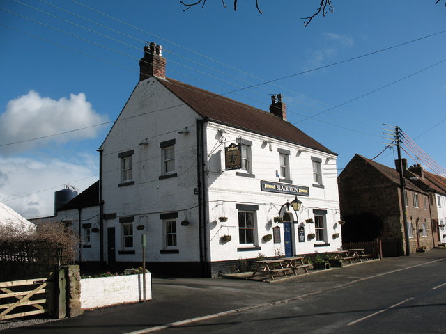
Skelton on Ure, Black Lion PH The benchmark is cut across 2 courses of bricks on the left hand side of the road facing wall.
Skelton on Ure, Black Lion PH
The benchmark is cut across 2 courses of bricks on the left hand side of the road facing wall.
Skelton on Ure, closed Black Lion PH There is a benchmark cut across 2 courses of bricks on the left hand side of the road facing wall. Another closed and boarded up village pub.
Skelton on Ure, closed Black Lion PH
There is a benchmark cut across 2 courses of bricks on the left hand side of the road facing wall. Another closed and boarded up village pub.
Skelton on Ure, Christ the Consoler The benchmark is cut into the north-east facing wall, directly under a marvellous rose shaped stained glass window.
Skelton on Ure, Christ the Consoler
The benchmark is cut into the north-east facing wall, directly under a marvellous rose shaped stained glass window.
Skelton on Ure, Christ the Consoler There is a benchmark cut into the north-east facing wall, directly under the marvellous rose shaped stained glass window.
Skelton on Ure, Christ the Consoler
There is a benchmark cut into the north-east facing wall, directly under the marvellous rose shaped stained glass window.
Skelton on Ure, Christ the Consoler This is the 2nd benchmark cut into the church wall, and is on the south east facing wall.
Skelton on Ure, Christ the Consoler
This is the 2nd benchmark cut into the church wall, and is on the south east facing wall.
Skelton on Ure, Christ the Consoler There is a 2nd benchmark cut into the church wall, and this one is cut into the south east facing wall.
Skelton on Ure, Christ the Consoler
There is a 2nd benchmark cut into the church wall, and this one is cut into the south east facing wall.
Skelton on Ure, 18 Main Street The benchmark is cut into the right side of the road facing wall of this house.
Skelton on Ure, 18 Main Street
The benchmark is cut into the right side of the road facing wall of this house.
Skelton on Ure, 18 Main Street There is a benchmark cut into the right side of the road facing wall of this house. The mark is about 18 inches from ground level and is slightly damaged.
Skelton on Ure, 18 Main Street
There is a benchmark cut into the right side of the road facing wall of this house. The mark is about 18 inches from ground level and is slightly damaged.
Show me another place!

High Common is located at Grid Ref: SE3769 (Lat: 54.116081, Lng: -1.4305328)

Division: West Riding

Administrative County: North Yorkshire

District: Harrogate

Police Authority: North Yorkshire

What 3 Words

///ombudsman.resonates.whips. Near Boroughbridge, North Yorkshire

Nearby Locations

High Common

Related Wikis

Vale of York services

The Vale of York services (also known as Kirby Hill services) is a future motorway service area (MSA) on the A1(M) in North Yorkshire, England. The MSA...

Skelton-on-Ure

Skelton-on-Ure or Skelton is a village and civil parish in the district and county of North Yorkshire, England. It is situated 1.9 miles (3 km) west of...

Church of Christ the Consoler

The Church of Christ the Consoler is a Victorian Gothic Revival church built in the Early English style by William Burges. It is located in the grounds...

Spectre of Newby Church

The Spectre of Newby Church (or the Newby Monk) is the name given to a figure found in a photograph taken in the Church of Christ the Consoler, on the...

Marton-le-Moor

Marton-le-Moor is a village and civil parish in the Harrogate district of North Yorkshire, England. It is very near the A1(M) motorway, 4 miles (6.4 km...

Kirby-on-the-Moor

Kirby-on-the-Moor, also called Kirby, is a village in the Kirby Hill civil parish about 1 mile (1.6 km) north of the market town of Boroughbridge, in...

Langthorpe

Langthorpe is a village and civil parish in the Harrogate district of North Yorkshire, England. The population of the civil parish taken at the 2011 Census...

Dishforth Airfield

Dishforth Airfield (ICAO: EGXD) is a former Royal Air Force and current British Army station in North Yorkshire, England. It was previously an Army Air...

Nearby Amenities

Located within 500m of 54.116081,-1.4305328
Kirby Mill
Addr Place: Skelton-on-Ure
Addr Postcode: YO51 9DP
Alt Name: Skelton Windmill
Building: windmill
Functional: no
Loc Name: The Old Mill
Man Made: windmill
Wikidata: Q26542803
Windmill Disused: yes
Windmill Type: tower
Windmill Vanes: no
Lat/Long: 54.1196626/-1.4267424
The data included in this document is from www.openstreetmap.org. The data is made available under ODbL.

Have you been to High Common?

Leave your review of High Common below (or comments, questions and feedback).