Brearton Moor
Downs, Moorland in Yorkshire Harrogate
England
Brearton Moor
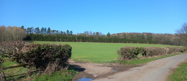
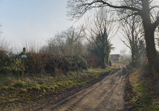
Brearton Moor is a picturesque area located in Yorkshire, England. Situated in the beautiful Nidderdale Valley, it is a part of the Yorkshire Dales National Park and covers an expanse of rolling hills and moorland. The moor is characterized by its unique combination of vast open spaces, heather-covered hills, and scattered patches of woodland.
Brearton Moor offers visitors a chance to immerse themselves in the natural beauty of the Yorkshire Downs. The moorland is home to a variety of flora and fauna, including heather, bilberry, and cotton grass, which create a vibrant and colorful landscape, especially during the summer months. The area is also inhabited by several bird species, such as curlews, lapwings, and red grouse, making it a popular spot for birdwatchers.
For outdoor enthusiasts, Brearton Moor provides ample opportunities for walking, hiking, and cycling. The network of footpaths and trails allows visitors to explore the moor at their own pace, providing stunning views of the surrounding countryside. Additionally, there are several designated picnic areas where visitors can relax and enjoy the tranquility of the moorland.
Brearton Moor is steeped in history, with evidence of ancient settlements and burial mounds dating back thousands of years. The area is also dotted with remnants of lead mining, showcasing its industrial past. Visitors can learn more about the history and heritage of the moor through the various information boards and interpretive signs placed throughout the area.
In conclusion, Brearton Moor in Yorkshire is a captivating destination for nature lovers and history enthusiasts alike. With its breathtaking scenery, diverse wildlife, and rich cultural heritage, it offers a truly immersive experience in the heart of the Yorkshire Downs.
If you have any feedback on the listing, please let us know in the comments section below.
Brearton Moor Images
Images are sourced within 2km of 54.039263/-1.5122529 or Grid Reference SE3260. Thanks to Geograph Open Source API. All images are credited.


Brearton Moor is located at Grid Ref: SE3260 (Lat: 54.039263, Lng: -1.5122529)
Division: West Riding
Administrative County: North Yorkshire
District: Harrogate
Police Authority: North Yorkshire
What 3 Words
///forest.compelled.card. Near Knaresborough, North Yorkshire
Nearby Locations
Related Wikis
Brearton
Brearton is a village and civil parish in the Harrogate borough of North Yorkshire, England, situated about 3 miles (4.8 km) north of Knaresborough. The...

Scotton, Harrogate
Scotton is a small village and civil parish in the Harrogate district of North Yorkshire, England with a population of 524 in the 2001 census, increasing...

Nidd
Nidd is a small village and civil parish in the Harrogate district of North Yorkshire, England. The population of the village taken at the 2011 census...

Farnham Mires
Farnham Mires is a Site of Special Scientific Interest, or SSSI, to the east of the village of Farnham, North Yorkshire, England. It consists of a spring...

Nidd Hall
Nidd Hall was a 19th-century country house, now a hotel, in the village of Nidd, North Yorkshire, England. It is a Grade II listed building. It is constructed...
Nidd Bridge railway station
Nidd Bridge railway station served the village of Nidd, North Yorkshire, England from 1848 to 1964 on the Leeds-Northallerton Railway. == History == The...

Nidderdale Greenway
The Nidderdale Greenway is a 4-mile (6.4 km) path that runs between Harrogate and Ripley in North Yorkshire, England. It uses a former railway line that...

Oak Beck
Oak Beck is a watercourse that flows eastwards across the northern part of Harrogate in North Yorkshire, England. The beck flows through a broad V-shaped...
Nearby Amenities
Located within 500m of 54.039263,-1.5122529Have you been to Brearton Moor?
Leave your review of Brearton Moor below (or comments, questions and feedback).