Ashley Down

Downs, Moorland in Berkshire

England

Ashley Down

Shalbourne Gliding Club Despite a public right of way crossing the grass strip used by Shalbourne Gliding Club, instructions are given to walkers on what to do if flying is taking place.  See: <span class="nowrap"><a title="http://shalbournegliding.co.uk" rel="nofollow ugc noopener" href="http://shalbournegliding.co.uk">Link</a><img style="margin-left:2px;" alt="External link" title="External link - shift click to open in new window" src="https://s1.geograph.org.uk/img/external.png" width="10" height="10"/></span>
Shalbourne Gliding Club Credit: James Harrison

Ashley Down, Berkshire, also known as the Ashley Downs or Moorland, is a picturesque area located in the county of Berkshire, England. It is situated within the larger region of the Berkshire Downs, an area renowned for its natural beauty and rich history.

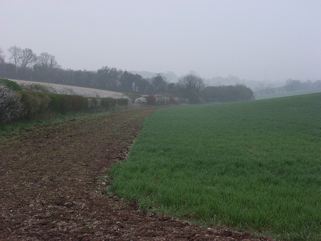
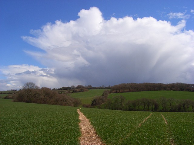
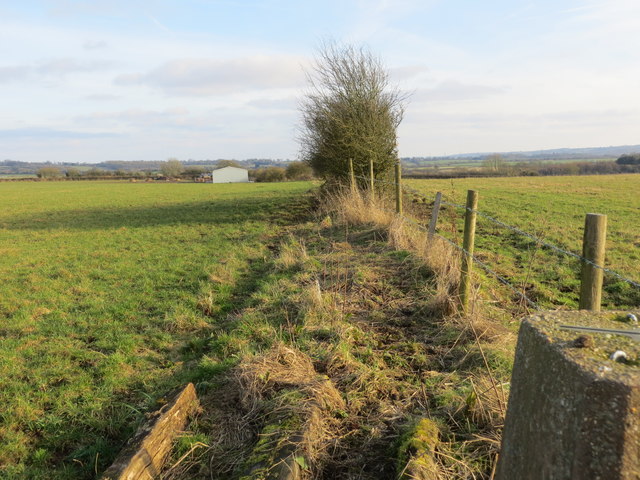
Ashley Down is characterized by its rolling hills, vast meadows, and stunning views of the surrounding countryside. The landscape is predominantly rural, with a patchwork of fields, woodlands, and small villages dotted throughout the area. The downs themselves are known for their chalky soil and lush grasslands, which provide excellent grazing for livestock.

The area is also home to a variety of wildlife, including birds, small mammals, and reptiles. The downs are particularly notable for their diverse bird population, with species such as skylarks, lapwings, and kestrels commonly spotted in the area.

In addition to its natural beauty, Ashley Down has a rich history that dates back centuries. The downs have been inhabited since prehistoric times, and evidence of ancient settlements can still be found in the form of burial mounds and earthworks. The area also played a significant role during the Roman occupation of Britain, with several Roman roads passing through the downs.

Today, Ashley Down is a popular destination for outdoor enthusiasts, offering an array of walking and cycling routes that allow visitors to explore the stunning countryside. The area's tranquil atmosphere and breathtaking scenery make it an ideal escape from the hustle and bustle of city life.

If you have any feedback on the listing, please let us know in the comments section below.

Ashley Down Images

Images are sourced within 2km of 51.351582/-1.5416786 or Grid Reference SU3261. Thanks to Geograph Open Source API. All images are credited.

Shalbourne Gliding Club Despite a public right of way crossing the grass strip used by Shalbourne Gliding Club, instructions are given to walkers on what to do if flying is taking place.  See: <span class="nowrap"><a title="http://shalbournegliding.co.uk" rel="nofollow ugc noopener" href="http://shalbournegliding.co.uk">Link</a><img style="margin-left:2px;" alt="External link" title="External link - shift click to open in new window" src="https://s1.geograph.org.uk/img/external.png" width="10" height="10"/></span>
Shalbourne Gliding Club
Despite a public right of way crossing the grass strip used by Shalbourne Gliding Club, instructions are given to walkers on what to do if flying is taking place. See: LinkExternal link
Un-named lane southwest of Moordown Farm
Un-named lane junction with Ashley Drove
Shalbourne Soaring Society - southern end of field About 1Km north of here is a static winch for launching gliders. The aircraft use the updraught from the nearby Rivar Hill and its associated ridge.
Shalbourne Soaring Society - southern end of field
About 1Km north of here is a static winch for launching gliders. The aircraft use the updraught from the nearby Rivar Hill and its associated ridge.
Farmland, Henley Looking down the dry valley from Ashley Drove. The hillside to the left has a white appearance due to the chalk and flints in the ploughed soil.
Farmland, Henley
Looking down the dry valley from Ashley Drove. The hillside to the left has a white appearance due to the chalk and flints in the ploughed soil.
Misty farmland near Oxenwood The view from the road near Cross Droves, the name of which reveals that this would previously have been sheep country.
Misty farmland near Oxenwood
The view from the road near Cross Droves, the name of which reveals that this would previously have been sheep country.
Farmland, Henley Looking down from the footpath south of Moordown Farm. The fields meet at a road junction on Ashley Drove.
Farmland, Henley
Looking down from the footpath south of Moordown Farm. The fields meet at a road junction on Ashley Drove.
Footpath through wheat, Henley The route of the path heading ENE from Moordown Farm is, unlike some locally, clearly marked. The path soon heads out of the grid-square on its way towards Buttermere such that the copse to the left is outside of the grid-square though most of the hedgerow in the valley is within it.
Footpath through wheat, Henley
The route of the path heading ENE from Moordown Farm is, unlike some locally, clearly marked. The path soon heads out of the grid-square on its way towards Buttermere such that the copse to the left is outside of the grid-square though most of the hedgerow in the valley is within it.
Bridleway near Rivar The bridleway takes riders and walkers from Ashley Drove to Rivar.
Bridleway near Rivar
The bridleway takes riders and walkers from Ashley Drove to Rivar.
Byway near Oxenwood The byway crosses Smay Down.
Byway near Oxenwood
The byway crosses Smay Down.
Dodge Ram 150 pickup, Shalbourne Classic Car Show 2016 Not all the vehicles on display at this year's show were in 'showroom' condition. This 1985 pickup truck is showing signs of having had a hard life. Very handy for trips to one's local Waitrose. None but the brave would park anywhere near this monster.
Dodge Ram 150 pickup, Shalbourne Classic Car Show 2016
Not all the vehicles on display at this year's show were in 'showroom' condition. This 1985 pickup truck is showing signs of having had a hard life. Very handy for trips to one's local Waitrose. None but the brave would park anywhere near this monster.
Road junction at the top of Rivar Bank Looking north-eastward.
Road junction at the top of Rivar Bank
Looking north-eastward.
Fence and hedge-line view from Botley Down Triangulation Pillar Looking south-eastward.
Fence and hedge-line view from Botley Down Triangulation Pillar
Looking south-eastward.
The junction of Burr Lane, Kingston Road and Rivar Road in Shalbourne Looking north-eastward.
The junction of Burr Lane, Kingston Road and Rivar Road in Shalbourne
Looking north-eastward.
Old Direction Sign - Signpost on village green, Spray Road, Ham Pawn finial - 3 arms; by the UC road, in parish of Ham (Kennet District), junction of Spray Road with Cutting Hill, on village green, by wooden bench.

To be surveyed

Milestone Society National ID: WI_SU3363
Old Direction Sign - Signpost on village green, Spray Road, Ham
Pawn finial - 3 arms; by the UC road, in parish of Ham (Kennet District), junction of Spray Road with Cutting Hill, on village green, by wooden bench. To be surveyed Milestone Society National ID: WI_SU3363
Farmland, Shalbourne Recently cultivated fields to the west of Ashley Drove, high up on the downs.
Farmland, Shalbourne
Recently cultivated fields to the west of Ashley Drove, high up on the downs.
Farmland, Shalbourne Recently cultivated fields on the dip slope of the downs to the south of Rivar.
Farmland, Shalbourne
Recently cultivated fields on the dip slope of the downs to the south of Rivar.
Farmland, Shalbourne A view towards Rivar Hill and Rivar Farm from the A338 above the village.
Farmland, Shalbourne
A view towards Rivar Hill and Rivar Farm from the A338 above the village.
Show me another place!

Ashley Down is located at Grid Ref: SU3261 (Lat: 51.351582, Lng: -1.5416786)

Unitary Authority: Wiltshire

Police Authority: Wiltshire

What 3 Words

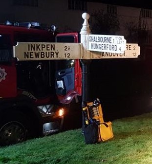
///visits.stag.rockets. Near Shalbourne, Wiltshire

Related Wikis

Ham Hill, Wiltshire

Ham Hill is a hill and area of chalk downland in Wiltshire, England, on the steep banks running alongside the road from the village of Ham to Buttermere...

Ham, Wiltshire

Ham is a small village and civil parish in Wiltshire, England. The parish borders the county of Berkshire, and the village lies about 3+1⁄4 miles (5.2...

Shalbourne

Shalbourne is a village and civil parish in the English county of Wiltshire, about 3 miles (4.8 km) southwest of Hungerford, Berkshire. The parish has...

Buttermere, Wiltshire

Buttermere is a small village and civil parish on the eastern boundary of Wiltshire, England, about 4.5 miles (7 km) south of Hungerford and 10 miles...

Fosbury House

Fosbury House is a Grade II listed country house northwest of the village of Fosbury in Wiltshire, England, about 11 miles (18 km) southeast of Marlborough...

Botley Down

Botley Down (grid reference SU292598) is a biological Site of Special Scientific Interest in Wiltshire, notified in 1989. == Sources == Natural England...

Fosbury

Fosbury is a small village in Wiltshire, England, on the eastern edge of the county, near Hampshire. It lies about 11 miles (18 km) southeast of Marlborough...

Inkpen Hill

Inkpen Hill is a summit in Berkshire, England, with a maximum elevation of 291 m (955 ft). The hill is about 7 miles (11 km) southwest of Newbury on the...

Nearby Amenities

Located within 500m of 51.351582,-1.5416786
Rivar
Place: locality
Source: OS OpenData StreetView
Lat/Long: 51.3530912/-1.5442461
Rivar Hill
Ele: 226
Natural: peak
Source: OS OpenData StreetView
Lat/Long: 51.3497849/-1.5441477
Post Box
Collection Times: Mo-Fr 09:00; Sa 07:00
Operator: Royal Mail
Operator Wikidata: Q638098
Post Box Type: lamp
Ref: SN8 113D
Royal Cypher: EIIR
Lat/Long: 51.3536193/-1.5449186
The data included in this document is from www.openstreetmap.org. The data is made available under ODbL.

Have you been to Ashley Down?

Leave your review of Ashley Down below (or comments, questions and feedback).