Bulford Down
Downs, Moorland in Wiltshire
England
Bulford Down

Bulford Down is a vast expanse of open land, located in the county of Wiltshire, England. It is situated in the northern part of Salisbury Plain, a chalk plateau renowned for its unique landscape and historical significance. Covering an area of approximately 2,000 acres, Bulford Down is characterized by its rolling hills, vast moorlands, and captivating views of the surrounding countryside.
The Down is primarily made up of chalk grassland, featuring a diverse range of flora and fauna. The slopes are dotted with patches of wildflowers, including buttercups, cowslips, and orchids, providing a vibrant burst of color during the spring and summer months. It is also home to various species of birds, such as skylarks, stonechats, and buzzards, making it a popular destination for birdwatching enthusiasts.
In addition to its natural beauty, Bulford Down has a rich historical heritage. Traces of prehistoric settlements, including burial mounds and earthworks, can be found throughout the area, indicating human activity dating back thousands of years. The Down also played a significant role during World War I and World War II, serving as a training ground for the military due to its remote location and expansive terrain.
Today, Bulford Down continues to be an important site for military training exercises, with the British Army often utilizing the area for training purposes. It is also a cherished recreational space for locals and visitors alike, offering opportunities for walking, hiking, and enjoying the breathtaking scenery.
If you have any feedback on the listing, please let us know in the comments section below.
Bulford Down Images
Images are sourced within 2km of 51.196665/-1.7086994 or Grid Reference SU2044. Thanks to Geograph Open Source API. All images are credited.


Bulford Down is located at Grid Ref: SU2044 (Lat: 51.196665, Lng: -1.7086994)
Unitary Authority: Wiltshire
Police Authority: Wiltshire
What 3 Words
///scared.burden.pictured. Near Bulford, Wiltshire
Nearby Locations
Related Wikis
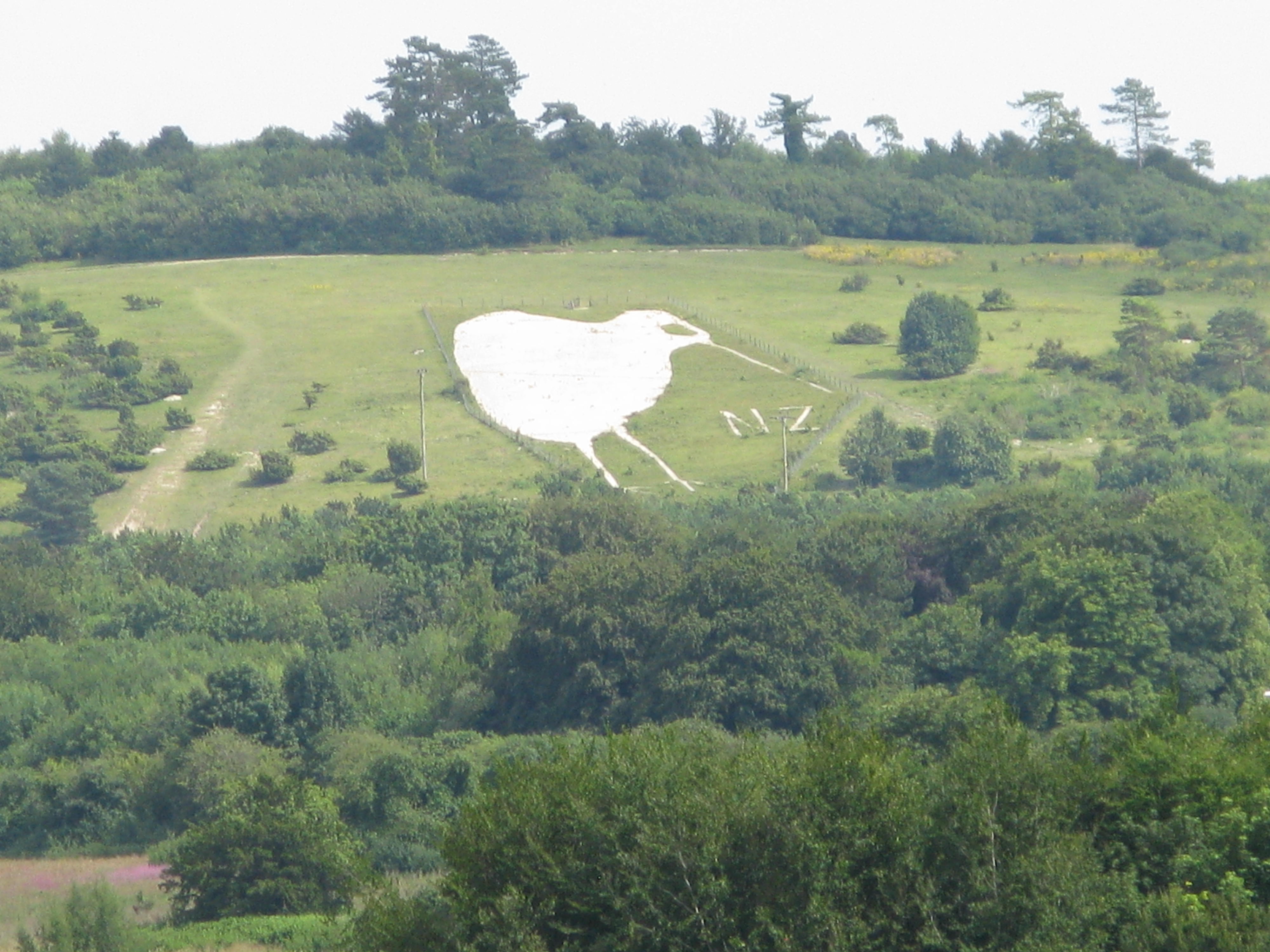
Bulford Kiwi
The Bulford Kiwi is a large depiction of a kiwi, carved in the chalk on Beacon Hill above the military town of Bulford on Salisbury Plain in Wiltshire...

Sling Camp
Sling Camp was a World War I camp occupied by New Zealand soldiers beside the then-military town of Bulford on the Salisbury Plain in Wiltshire, England...
Bulford Camp
Bulford Camp is a military camp on Salisbury Plain in Wiltshire, England. Established in 1897, the site continues in use as a large British Army base....

Cholderton
Cholderton, or more properly West Cholderton, is a village and civil parish in the Bourne Valley of Wiltshire, England. The village is about 4 miles (6...
Battle of the Beanfield
The Battle of the Beanfield took place over several hours on 1 June 1985, when Wiltshire Police prevented The Peace Convoy, a convoy of several hundred...

Shipton Bellinger
Shipton Bellinger is a village and civil parish in Hampshire, England. Shipton Bellinger is about 5 miles (8 km) north-east of the town of Amesbury and...
Wilbury House
Wilbury House or Wilbury Park is an 18th-century Neo-Palladian country house in the parish of Newton Tony, Wiltshire in South West England, about 8.7 miles...

A338 road
The A338 is a major primary route in southern England, that runs from the junction with the A35 at Poole in Dorset to the junction with the A420 at Besselsleigh...
Nearby Amenities
Located within 500m of 51.196665,-1.7086994Have you been to Bulford Down?
Leave your review of Bulford Down below (or comments, questions and feedback).