Haxton Down

Downs, Moorland in Wiltshire

England

Haxton Down

Weather Hill, Wiltshire Summer wild flowers on Salisbury Plain in the vicinity of Weather Hill.
Weather Hill, Wiltshire Credit: Rebecca A Wills

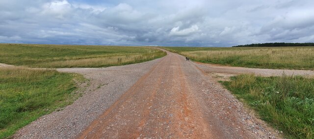
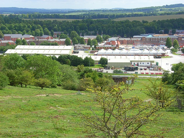
Haxton Down, located in the county of Wiltshire, England, is a picturesque area situated on the edge of Salisbury Plain. Covering an expanse of moorland and rolling hills, it is a part of the larger Salisbury Plain Training Area, which is utilized by the British Army for military training purposes.

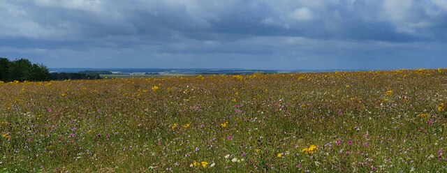
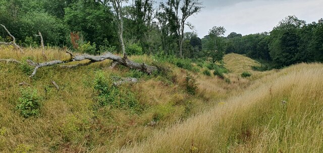
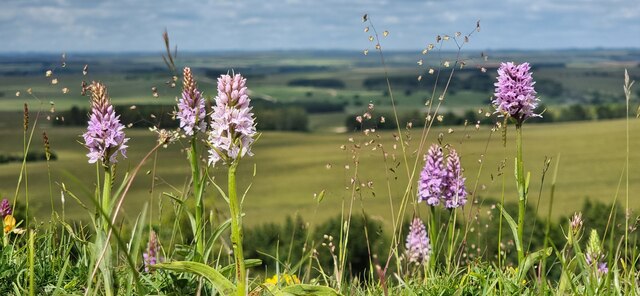
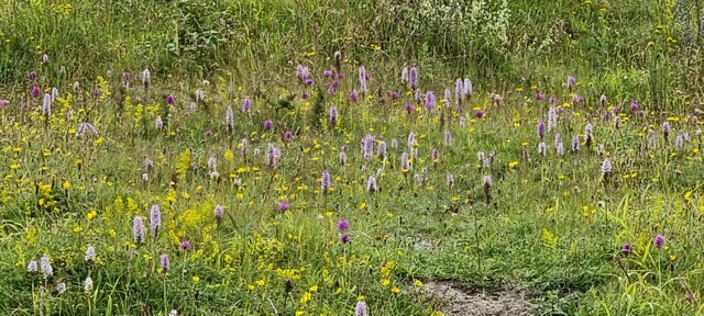
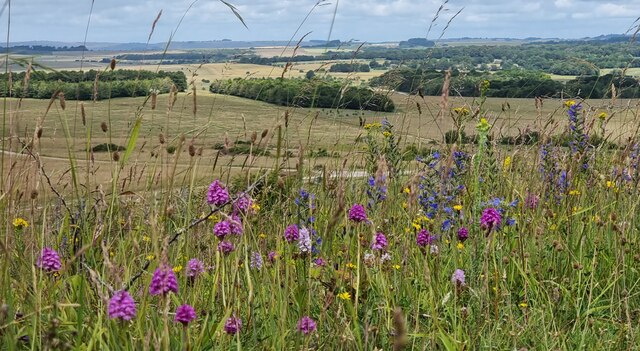
The landscape of Haxton Down is characterized by undulating hills covered with a mixture of grasses, heather, and gorse. The area is known for its outstanding natural beauty and is a popular destination for nature lovers, hikers, and birdwatchers. The open vistas offer breathtaking views of the surrounding countryside, making it a haven for outdoor enthusiasts.

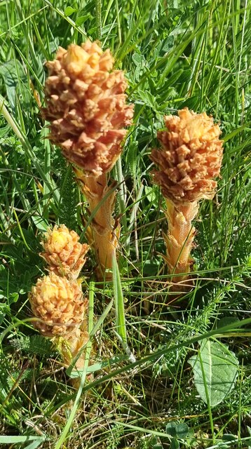
Haxton Down is home to a diverse range of flora and fauna. The heathland supports a variety of wildlife, including deer, rabbits, and numerous species of birds, including skylarks and stonechats. It also serves as a habitat for several rare and protected species, such as the silver-studded blue butterfly and the nightjar.

The area is rich in history, with archaeological sites dating back to the prehistoric period. The nearby Stonehenge, a world-famous UNESCO World Heritage Site, is a testament to the ancient past of this region.

Access to Haxton Down is generally unrestricted for visitors, allowing them to explore and appreciate the beauty of the area. However, it is important to respect any military exercises or training activities that may be taking place within the Salisbury Plain Training Area and adhere to any safety guidelines or restrictions in place.

If you have any feedback on the listing, please let us know in the comments section below.

Haxton Down Images

Images are sourced within 2km of 51.257608/-1.7109515 or Grid Reference SU2050. Thanks to Geograph Open Source API. All images are credited.

Weather Hill, Wiltshire Summer wild flowers on Salisbury Plain in the vicinity of Weather Hill.
Weather Hill, Wiltshire
Summer wild flowers on Salisbury Plain in the vicinity of Weather Hill.
Weather Hill, Wiltshire Wild flowers on Salisbury Plain in the vicinity of Weather Hill.
Weather Hill, Wiltshire
Wild flowers on Salisbury Plain in the vicinity of Weather Hill.
Snail Down, Wiltshire Summer grassland and showers on Salisbury Plain!
Snail Down, Wiltshire
Summer grassland and showers on Salisbury Plain!
Sidbury Hill, Wiltshire The southern defensive ditch of Sidbury Hillfort.
Sidbury Hill, Wiltshire
The southern defensive ditch of Sidbury Hillfort.
Haxton Down, Wiltshire Looking west along a bridleway from the Old Marlborough Road on Haxton Down. This area is within the military Salisbury Plain Training Area.
Haxton Down, Wiltshire
Looking west along a bridleway from the Old Marlborough Road on Haxton Down. This area is within the military Salisbury Plain Training Area.
Weather Hill, Wiltshire A group of Knapweed Broomrapes. They are parasitic and also contain no chlorophyll, which explains the absence of green pigmentation. They are a relatively common sight on Salisbury Plain.
Weather Hill, Wiltshire
A group of Knapweed Broomrapes. They are parasitic and also contain no chlorophyll, which explains the absence of green pigmentation. They are a relatively common sight on Salisbury Plain.
Sidbury Hill, Wiltshire Common spotted orchids on the western defensive slopes of Sidbury Hillfort.
Sidbury Hill, Wiltshire
Common spotted orchids on the western defensive slopes of Sidbury Hillfort.
Snail Down, Wiltshire A common sight at this time of year - the vibrant five spot burnet moth feeding on viper's bugloss.
Snail Down, Wiltshire
A common sight at this time of year - the vibrant five spot burnet moth feeding on viper's bugloss.
Sidbury Hillfort Common Spotted and Pyramidal Orchids on the defensive ditches of Sidbury Hillfort.
Sidbury Hillfort
Common Spotted and Pyramidal Orchids on the defensive ditches of Sidbury Hillfort.
Sidbury Hillfort Common Spotted and Pyramidal Orchids on the western defensive ditches of Sidbury Hillfort.
Sidbury Hillfort
Common Spotted and Pyramidal Orchids on the western defensive ditches of Sidbury Hillfort.
Haxton Down, Wiltshire Tank tracks on Haxton Down, an area within the MoD Salisbury Plain Training Area.
Haxton Down, Wiltshire
Tank tracks on Haxton Down, an area within the MoD Salisbury Plain Training Area.
Downland, Collingbourne Ducis A more open landscape to the north associated with the Everleigh parachute drop-zone has given way to rougher grassland and scrubby woodland.
Downland, Collingbourne Ducis
A more open landscape to the north associated with the Everleigh parachute drop-zone has given way to rougher grassland and scrubby woodland.
Haxton O, Wiltshire Looking north over grassland from Haxton O. This area is within the military Salisbury Plain Training Area.
Haxton O, Wiltshire
Looking north over grassland from Haxton O. This area is within the military Salisbury Plain Training Area.
Sun Plantation, Wiltshire Looking north over a bridleway crossroads, on the Old Marlborough Road, in the vicinity of Sun Plantation. This area is within the military Salisbury Plain Training Area.
Sun Plantation, Wiltshire
Looking north over a bridleway crossroads, on the Old Marlborough Road, in the vicinity of Sun Plantation. This area is within the military Salisbury Plain Training Area.
Old Milestone by Old Marlborough Road on Figheldean Down Salisbury Roman stone by the bridleway, in parish of Figheldean (Salisbury District), Figheldean Down; opposite fenced off tumuli, 12m from road and marked by 4 wooden posts.

Inscription reads:-
To
Salisbury
XIII Miles
To
Marlbro
XIV

Wiltshire and Swindon HER.
HER Number: MWI17707 <span class="nowrap"><a title="https://www.heritagegateway.org.uk/Gateway/Results_Single.aspx?uid=MWI17707&resourceID=1047" rel="nofollow ugc noopener" href="https://www.heritagegateway.org.uk/Gateway/Results_Single.aspx?uid=MWI17707&resourceID=1047">Link</a><img style="margin-left:2px;" alt="External link" title="External link - shift click to open in new window" src="https://s1.geograph.org.uk/img/external.png" width="10" height="10"/></span>

Surveyed but may be destroyed by tank Nov 2014

Milestone Society National ID: WI_MLSA14
Old Milestone by Old Marlborough Road on Figheldean Down
Salisbury Roman stone by the bridleway, in parish of Figheldean (Salisbury District), Figheldean Down; opposite fenced off tumuli, 12m from road and marked by 4 wooden posts. Inscription reads:- To Salisbury XIII Miles To Marlbro XIV Wiltshire and Swindon HER. HER Number: MWI17707 LinkExternal link Surveyed but may be destroyed by tank Nov 2014 Milestone Society National ID: WI_MLSA14
Downland and plantations, Fittleton An unnamed group of conifers and Sun Plantation to the south-west of Sidbury Hill.
Downland and plantations, Fittleton
An unnamed group of conifers and Sun Plantation to the south-west of Sidbury Hill.
Sidbury Hill Plantation Leaf litter in Sidbury Hill Plantation.
Sidbury Hill Plantation
Leaf litter in Sidbury Hill Plantation.
Sidbury from the west A view of Sidbury hillfort from a range of slightly less than 3km.  For me, this distant view shows just how well-chosen Sidbury was as a defensible site.  The OS gives a spot-height for Sidbury of 223m, whereas my photo was taken from an elevation of about 125m - a fairly typical height for the high plain.

The clump of woodland in the dip (and in shade) is known as Haxton O.  The track is one of the many MoD tracks in the Salisbury Plain training area.
Sidbury from the west
A view of Sidbury hillfort from a range of slightly less than 3km. For me, this distant view shows just how well-chosen Sidbury was as a defensible site. The OS gives a spot-height for Sidbury of 223m, whereas my photo was taken from an elevation of about 125m - a fairly typical height for the high plain. The clump of woodland in the dip (and in shade) is known as Haxton O. The track is one of the many MoD tracks in the Salisbury Plain training area.
Show me another place!

Haxton Down is located at Grid Ref: SU2050 (Lat: 51.257608, Lng: -1.7109515)

Unitary Authority: Wiltshire

Police Authority: Wiltshire

What 3 Words

///community.thank.refilled. Near Tidworth, Wiltshire

Nearby Locations

Haxton Down

Related Wikis

Sidbury Hill

Sidbury Hill, or Sidbury Camp, is the site of an Iron Age bivallate hillfort on the eastern edge of Salisbury Plain in Wiltshire, England. The site is...

Everleigh, Wiltshire

Everleigh, pronounced and also sometimes spelt Everley, is a village and civil parish in east Wiltshire, England, about 4+1⁄2 miles (7 km) southeast of...

St Peter's Church, Everleigh

St Peter's Church, in Everleigh, Wiltshire, England was built in 1813 by John Morlidge for F.D. Astley. It is recorded in the National Heritage List for...

Netheravon Airfield

Netheravon Airfield is a Ministry of Defence grass strip airfield on Salisbury Plain, in Wiltshire, England. Established in 1913 by the Royal Flying Corps...

Tidworth Camp

Tidworth Camp is a military installation at Tidworth in Wiltshire, England. It forms part of the Tidworth, Netheravon and Bulford (TidNBul) Garrison....

The Wellington Academy

The Wellington Academy, founded in 2009, is an 11–19 non-selective state-funded school near Ludgershall, Wiltshire, England. The school has academy status...

Tidworth

Tidworth is a garrison town and civil parish in south-east Wiltshire, England, on the eastern edge of Salisbury Plain. Lying on both sides of the A338...

Tedworth House

Tedworth House, also known as South Tidworth House, is a 19th-century country house in Tidworth, Wiltshire, England. It is a Grade II* listed building...

Nearby Amenities

Located within 500m of 51.257608,-1.7109515
Archaeological Site: tumulus
Historic: archaeological_site
Lat/Long: 51.2605954/-1.7147992
Archaeological Site: tumulus
Historic: archaeological_site
Lat/Long: 51.2598753/-1.7145095
Archaeological Site: tumulus
Historic: archaeological_site
Lat/Long: 51.2606089/-1.7086302
Archaeological Site: tumulus
Historic: archaeological_site
Lat/Long: 51.2602584/-1.7054168
Archaeological Site: tumulus
Historic: archaeological_site
Lat/Long: 51.2570302/-1.7061759
Archaeological Site: tumulus
Historic: archaeological_site
Lat/Long: 51.2605435/-1.7151367
Archaeological Site: tumulus
Historic: archaeological_site
Lat/Long: 51.2598396/-1.7150641
Archaeological Site: tumulus
Historic: archaeological_site
Lat/Long: 51.2601023/-1.7145302
The data included in this document is from www.openstreetmap.org. The data is made available under ODbL.

Have you been to Haxton Down?

Leave your review of Haxton Down below (or comments, questions and feedback).