Shirley Common

Downs, Moorland in Hampshire New Forest

England

Shirley Common

New Forest ponies by Forest Road
New Forest ponies by Forest Road Credit: Rod Allday

Shirley Common is a picturesque area located in Hampshire, England. Situated in the heart of the county, it covers a vast expanse of land, encompassing both downs and moorland. The common is known for its outstanding natural beauty and is a popular destination for outdoor enthusiasts and nature lovers alike.

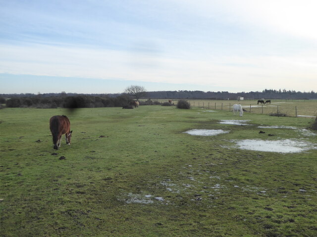
The downs of Shirley Common are characterized by their rolling hills and expansive grasslands. This area provides a haven for various species of plants and wildlife, including rare and protected species such as orchids and butterflies. The views from the downs are breathtaking, offering panoramic vistas of the surrounding countryside.

In contrast, the moorland of Shirley Common offers a different landscape altogether. Here, visitors can expect to find vast stretches of open heathland, punctuated by patches of gorse and heather. This unique ecosystem is home to a diverse range of wildlife, including birds such as skylarks, stonechats, and kestrels.

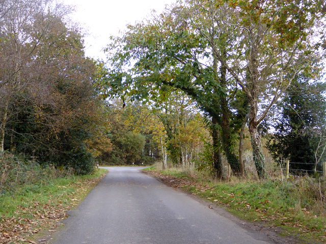
The common is crisscrossed with a network of footpaths and bridleways, making it a paradise for walkers and cyclists. It also offers ample opportunities for horse riding, with designated trails for equestrian activities. The common is well-maintained, with fences and gates in place to protect the sensitive habitats and ensure the safety of visitors.

Shirley Common is easily accessible, with nearby parking facilities and regular public transport connections. It provides a tranquil escape from the hustle and bustle of everyday life, with ample opportunities for relaxation, exploration, and immersing oneself in the natural beauty of Hampshire.

If you have any feedback on the listing, please let us know in the comments section below.

Shirley Common Images

Images are sourced within 2km of 50.796163/-1.7293271 or Grid Reference SZ1999. Thanks to Geograph Open Source API. All images are credited.

New Forest ponies by Forest Road
Common at Pigsty Hill
Pasture at Pigsty Hill
Braggers Lane Heading towards Thorney Hill.
Braggers Lane
Heading towards Thorney Hill.
Cattle grid on Braggers Lane
Pasture on Whitefield Hill
Avon Tyrrell - Stable Block Grade II listed stable block in 'Arts and Crafts' style by W R Lethaby in 1892 for Lord Manners.
Avon Tyrrell - Stable Block
Grade II listed stable block in 'Arts and Crafts' style by W R Lethaby in 1892 for Lord Manners.
Pond near Lugden Bottom
View across pond near Lugden Bottom
Former gateposts into Dur Hill Inclosure Most of the inclosure is no longer gated and fenced.
Former gateposts into Dur Hill Inclosure
Most of the inclosure is no longer gated and fenced.
Trig point in Dur Hill Inclosure Presumably set up when there were open views, subsequently surrounded by trees as the inclosure was established, and now out in the open again.
Trig point in Dur Hill Inclosure
Presumably set up when there were open views, subsequently surrounded by trees as the inclosure was established, and now out in the open again.
Near Cross Ways Undulating heathland to the north west of the crossroads north of Thorney Hill
Near Cross Ways
Undulating heathland to the north west of the crossroads north of Thorney Hill
Thorney Hill crossroads A substantial array of street furniture on show at this crossroads and the 30 sign is probably obscuring the Give Way sign.
Thorney Hill crossroads
A substantial array of street furniture on show at this crossroads and the 30 sign is probably obscuring the Give Way sign.
Braggers Lane The apparently quieter arm of the crossroads
Braggers Lane
The apparently quieter arm of the crossroads
WWII Hampshire - RAF Holmsley South airfield: Battle HQ (1) -
Airfield Battle Headquarters: DoB ID: e11366

Best described as the 'site of' as it's in very poor condition with its brick built cupola removed along with the entrance. The underground bunker has been sealed and backfilled, and the emergency exit concreted over (the upper section of its exit ladder is still visible).

Holmsley South was an RAF Coastal Command airfield that opened in September 1942 with 547 Squadron equipped with Mk VIII Wellingtons; they were later reinforced with the B24 Liberators of the USAAF. After Operation Torch had successfully concluded, Armstrong Whitley, and Handley Page Halifax bombers were based here, the latter becoming a familiar sight in the skies over the New Forest throughout the rest of the war. 

The build-up to D-Day saw the arrival of Canadian Spitfires in March, and in April, rocket firing Typhoons, and 418 Sqdn Mosquitoes, the former leaving in June, the latter in July. Further information: <span class="nowrap"><a title="https://nfknowledge.org/contributions/holmsley-south-airfield-overview/#map=10/-1.7/50.79/0/24:0:0.6" rel="nofollow ugc noopener" href="https://nfknowledge.org/contributions/holmsley-south-airfield-overview/#map=10/-1.7/50.79/0/24:0:0.6">Link</a><img style="margin-left:2px;" alt="External link" title="External link - shift click to open in new window" src="https://s1.geograph.org.uk/img/external.png" width="10" height="10"/></span>

<a href="https://www.geograph.org.uk/photo/5047212">SZ2099 : WWII Hampshire - RAF Holmsley South airfield: Battle HQ (2)</a>
WWII Hampshire - RAF Holmsley South airfield: Battle HQ (1)
- Airfield Battle Headquarters: DoB ID: e11366 Best described as the 'site of' as it's in very poor condition with its brick built cupola removed along with the entrance. The underground bunker has been sealed and backfilled, and the emergency exit concreted over (the upper section of its exit ladder is still visible). Holmsley South was an RAF Coastal Command airfield that opened in September 1942 with 547 Squadron equipped with Mk VIII Wellingtons; they were later reinforced with the B24 Liberators of the USAAF. After Operation Torch had successfully concluded, Armstrong Whitley, and Handley Page Halifax bombers were based here, the latter becoming a familiar sight in the skies over the New Forest throughout the rest of the war. The build-up to D-Day saw the arrival of Canadian Spitfires in March, and in April, rocket firing Typhoons, and 418 Sqdn Mosquitoes, the former leaving in June, the latter in July. Further information: LinkExternal link SZ2099 : WWII Hampshire - RAF Holmsley South airfield: Battle HQ (2)
WWII Hampshire - RAF Holmsley South airfield: Battle HQ (2) -
Airfield Battle Headquarters: DoB ID: e11366

<a href="https://www.geograph.org.uk/photo/6844108">SZ2198 : WWII Hampshire: RAF Holmsley South airfield - Cloud Height Projector plinth (1)</a>
WWII Hampshire - RAF Holmsley South airfield: Battle HQ (2)
Stream course under trees, New Forest Towards the head of what, combined with other sources, becomes the Avon Water lower down.
Stream course under trees, New Forest
Towards the head of what, combined with other sources, becomes the Avon Water lower down.
Forest Road Here the boundary of the unenclosed New Forest, which is to the left.
Forest Road
Here the boundary of the unenclosed New Forest, which is to the left.
Show me another place!

Shirley Common is located at Grid Ref: SZ1999 (Lat: 50.796163, Lng: -1.7293271)

Administrative County: Hampshire

District: New Forest

Police Authority: Hampshire

What 3 Words

///cape.saved.dumps. Near Bransgore, Hampshire

Related Wikis

All Saints' Church, Thorney Hill

All Saints' Church is a Church of England church in Thorney Hill, Hampshire, England. It was built in 1905–06 and has been a Grade I listed building since...

Avon Tyrrell House

Avon Tyrrell is an historic manor within the parish of Sopley, Hampshire. It is situated within the New Forest, near Christchurch. The present manor house...

Bransgore

Bransgore is a village and civil parish within the New Forest District, Hampshire, England. The village developed in the 19th century when a church and...

RAF Holmsley South

Royal Air Force Holmsley South or more simply RAF Holmsley South is a former Royal Air Force station in Hampshire, England. The airfield is located approximately...

RAF Winkton

Royal Air Force Winkton, or more simply RAF Winkton, is a former Royal Air Force Advanced Landing Ground previously in Hampshire but now, due to County...

RAF Sopley

RAF Sopley was a World War II station, codenamed Starlight, near the village of Sopley in Hampshire. The Radar Station was opened in December 1940. In...

Sandford, Hampshire

Sandford is a small hamlet in the New Forest National Park of Hampshire, England. The nearest town to Sandford is Ringwood, which is approximately 2.6...

Bagnum

Bagnum is a hamlet in the English county of Hampshire. The settlement is within the civil parish of Ringwood (where the 2011 Census was included), and...

Have you been to Shirley Common?

Leave your review of Shirley Common below (or comments, questions and feedback).