Burnt Heath

Downs, Moorland in Yorkshire Harrogate

England

Burnt Heath

Mechanised Shepherd, Dallow Moor Modern shepherd herding his sheep off the moor, and following this track to Harper Hill
Mechanised Shepherd, Dallow Moor Credit: Chris Heaton

Burnt Heath is a picturesque area located in Yorkshire, England, known for its stunning natural beauty and diverse landscapes. Situated on the Yorkshire Downs, Burnt Heath encompasses both moorland and rolling hills, offering visitors a unique and captivating experience.

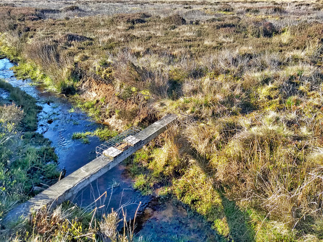
The heath is characterized by its expansive stretches of heather, which provide a vibrant purple hue to the landscape during the summer months. This creates a stunning contrast against the deep green of the surrounding grasslands and the blue skies overhead. The area is a haven for wildlife, with numerous species of birds, mammals, and insects calling it home.

The Yorkshire Downs within Burnt Heath offer breathtaking panoramic views of the surrounding countryside. The undulating hills and valleys create a sense of tranquility and isolation, making it a popular destination for hikers, nature enthusiasts, and photographers.

Moorland also forms a significant part of Burnt Heath's landscape, with vast expanses of open space and rugged terrain. The moors are adorned with patches of cotton grass and gorse bushes, adding to the area's charm and diversity. Visitors can often see herds of grazing sheep or the occasional deer roaming freely.

Walkers can explore the numerous footpaths and trails that wind their way through Burnt Heath, providing access to some of the most stunning vistas in the region. The area is also a popular destination for birdwatching, with a variety of species, including curlews and lapwings, making their nests here.

Overall, Burnt Heath in Yorkshire is a haven for nature lovers, offering a serene escape from the bustling cities and a chance to immerse oneself in the natural wonders of the Yorkshire countryside.

If you have any feedback on the listing, please let us know in the comments section below.

Burnt Heath Images

Images are sourced within 2km of 54.110026/-1.7188781 or Grid Reference SE1868. Thanks to Geograph Open Source API. All images are credited.

Mechanised Shepherd, Dallow Moor Modern shepherd herding his sheep off the moor, and following this track to Harper Hill
Mechanised Shepherd, Dallow Moor
Modern shepherd herding his sheep off the moor, and following this track to Harper Hill
Tractor parked on the moor A rather old and battered tractor parked on the moor near to Long Rod standing stone. Kettlestang Shooting House can be seen in the distance close to the small stand of trees.
Tractor parked on the moor
A rather old and battered tractor parked on the moor near to Long Rod standing stone. Kettlestang Shooting House can be seen in the distance close to the small stand of trees.
Old Wife on the moor This short standing stone is known as 'Old Wife', for what reason I'm unsure. It appears to stand in the middle of nowhere between a modern 4X4 track and a line of grouse butts, but if one looks at OS maps of the 19thC the reason for its existence appears clearer as a footpath or track is shown crossing the moor roughly east to west passing both this stone and that of Long Rod some 700m further west. Both stones may well have been waymarkers on an ancient route, now lost, between Nidderdale and Dallow etc. Grouse butts on this moor appear to have names, the small sign in the background naming this area as 'Jonathan's Line'.
Old Wife on the moor
This short standing stone is known as 'Old Wife', for what reason I'm unsure. It appears to stand in the middle of nowhere between a modern 4X4 track and a line of grouse butts, but if one looks at OS maps of the 19thC the reason for its existence appears clearer as a footpath or track is shown crossing the moor roughly east to west passing both this stone and that of Long Rod some 700m further west. Both stones may well have been waymarkers on an ancient route, now lost, between Nidderdale and Dallow etc. Grouse butts on this moor appear to have names, the small sign in the background naming this area as 'Jonathan's Line'.
Old Wife I think. Not quite in the same location as the map according to the GPS on my phone. And I could nothing else likely.
Old Wife
I think. Not quite in the same location as the map according to the GPS on my phone. And I could nothing else likely.
A boulder
A boulder
Fenn trap, Dallow Moor
Jonathon's Row
Jonathon's Row
Skell Gill Woods Looking over to Skell Gill Woods from the Land Rover track.
Skell Gill Woods
Looking over to Skell Gill Woods from the Land Rover track.
North Oaks
North Oaks
The noisy cow Kingstone Farm in the background
The noisy cow
Kingstone Farm in the background
Moor Top Junction & Cattle Grid
Bishop's Moor An "entry point" as part of the new right to roam onto the moor on High Bishopside.
Bishop's Moor
An "entry point" as part of the new right to roam onto the moor on High Bishopside.
Skell Gill Bridge
Skell Gill Bridge
The Blazefield Road from Above North Oaks On Pateley Moor, looking SSW along the minor road to Blazefield from just above North Oaks towards Combs Ridge. The crossroads is clearly visible ahead.
The Blazefield Road from Above North Oaks
On Pateley Moor, looking SSW along the minor road to Blazefield from just above North Oaks towards Combs Ridge. The crossroads is clearly visible ahead.
Skell Gill Looking south-east along Skell Gill from Skell Gill Bridge. Just beyond the tree square SE1968 begins.
Skell Gill
Looking south-east along Skell Gill from Skell Gill Bridge. Just beyond the tree square SE1968 begins.
Skell Gill Bridge Looking west to Skell Gill Bridge and Bishop's Moor <a href="https://www.geograph.org.uk/gridref/SE1768">SE1768</a> beyond.
Skell Gill Bridge
Looking west to Skell Gill Bridge and Bishop's Moor SE1768 beyond.
Most of North Yorkshire Looking slightly east of south, this photograph covers many squares, from <a href="https://www.geograph.org.uk/gridref/SE1867">SE1867</a> (where I'm standing) to RAF Menwith Hill at <a href="https://www.geograph.org.uk/gridref/SE2057">SE2057</a> and the radio mast on the hill at <a href="https://www.geograph.org.uk/gridref/SE2151">SE2151</a>.
Most of North Yorkshire
Looking slightly east of south, this photograph covers many squares, from SE1867 (where I'm standing) to RAF Menwith Hill at SE2057 and the radio mast on the hill at SE2151.
Road at Skell Gill Bank This road connects Pateley Bridge to Kirkby Malzeard and Masham - at this point it crosses Dallow Moor, very near to its crossing of Skell Gill
Road at Skell Gill Bank
This road connects Pateley Bridge to Kirkby Malzeard and Masham - at this point it crosses Dallow Moor, very near to its crossing of Skell Gill
Show me another place!

Burnt Heath is located at Grid Ref: SE1868 (Lat: 54.110026, Lng: -1.7188781)

Division: West Riding

Administrative County: North Yorkshire

District: Harrogate

Police Authority: North Yorkshire

What 3 Words

///fonts.fabric.meatball. Near Pateley Bridge, North Yorkshire

Nearby Locations

Hell Hole Burnt Heath

Related Wikis

High and Low Bishopside

High and Low Bishopside is a civil parish in Nidderdale in the Harrogate district, in the county of North Yorkshire, England. It includes the town of Pateley...

Nidderdale Museum

Nidderdale Museum is a local and social history museum in the market town of Pateley Bridge in Nidderdale, one of the Yorkshire Dales, in North Yorkshire...

Nidderdale AONB

The Nidderdale AONB is an Area of Outstanding Natural Beauty in North Yorkshire, England, bordering the Yorkshire Dales National Park to the east and south...

Nidderdale

Nidderdale, historically also known as Netherdale, is one of the Yorkshire Dales (although outside the Yorkshire Dales National Park) in North Yorkshire...

Pateley Playhouse

The Pateley Playhouse is a small amateur-run theatre in the town of Pateley Bridge in Nidderdale, North Yorkshire, England. The building was initially...

Wath-in-Nidderdale

Wath, sometimes known as Wath-in-Nidderdale to distinguish it from other places named Wath, is a village in the Harrogate district of North Yorkshire,...

Wilsill

Wilsill is a village in Nidderdale in the Harrogate district of North Yorkshire, England. It is about 2 miles (3 km) east of Pateley Bridge on the B6165...

Pateley Bridge railway station (Nidd Valley Light Railway)

Pateley Bridge railway station (NVLR) was a railway station serving the southern terminus of the Nidd Valley Light Railway, in Pateley Bridge, North Yorkshire...

Have you been to Burnt Heath?

Leave your review of Burnt Heath below (or comments, questions and feedback).