Haddon Grove

Downs, Moorland in Derbyshire Derbyshire Dales

England

Haddon Grove

Magpie Mine in the Mist, Derbyshire The ruins of the Magpie Mine appearing out of the mist on a winter afternoon in the Derbyshire Peak District.
Magpie Mine in the Mist, Derbyshire Credit: Andrew Tryon

Haddon Grove is a picturesque village nestled in the heart of Derbyshire, England. Situated in the serene surroundings of the Derbyshire Dales, it offers a tranquil getaway for nature lovers and outdoor enthusiasts alike. The village is located within close proximity to the stunning Peak District National Park, making it an ideal base for exploring the region's natural beauty.

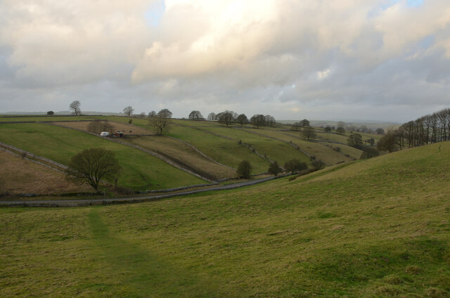
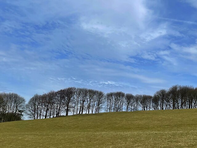
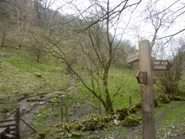
One of the prominent features of Haddon Grove is its downs and moorland. The area boasts expansive stretches of rolling hills and open grasslands, providing breathtaking views of the surrounding countryside. Hikers and walkers can take advantage of the numerous trails that wind through the downs, offering opportunities to discover hidden gems, ancient ruins, and diverse wildlife.

The village itself is known for its charming stone cottages, which add to its traditional English countryside appeal. It offers a range of accommodation options, including cozy bed and breakfasts and self-catering cottages, ensuring visitors have a comfortable and enjoyable stay.

For history enthusiasts, nearby attractions such as Haddon Hall and Chatsworth House offer a glimpse into the area's rich heritage and architectural splendor. These stately homes are renowned for their grandeur and have been featured in several films and television shows.

In addition to its natural and historical attractions, Haddon Grove benefits from its close proximity to the town of Bakewell, famous for its delectable Bakewell tarts. Visitors can indulge in these sweet treats and explore the town's charming streets lined with boutique shops and cafes.

Overall, Haddon Grove, Derbyshire, offers a perfect combination of natural beauty, historical significance, and quaint village charm, making it an idyllic destination for those seeking a peaceful and authentic English countryside experience.

If you have any feedback on the listing, please let us know in the comments section below.

Haddon Grove Images

Images are sourced within 2km of 53.195062/-1.7343836 or Grid Reference SK1766. Thanks to Geograph Open Source API. All images are credited.

Magpie Mine in the Mist, Derbyshire The ruins of the Magpie Mine appearing out of the mist on a winter afternoon in the Derbyshire Peak District.
Magpie Mine in the Mist, Derbyshire
The ruins of the Magpie Mine appearing out of the mist on a winter afternoon in the Derbyshire Peak District.
View of Kirk Dale, near Bakewell, Derbyshire
Public Footpath in Upper Kirk Dale, Derbyshire The footpath from Sheldon towards Over Haddon, where it crosses through Kirk Dale, in the Derbyshire Peak District.
Public Footpath in Upper Kirk Dale, Derbyshire
The footpath from Sheldon towards Over Haddon, where it crosses through Kirk Dale, in the Derbyshire Peak District.
Stile at the corner of Four Fields, Derbyshire A typical stone stile on a public footpath in the Derbyshire Peak District, at Melbourne Farm, near Bakewell.
Stile at the corner of Four Fields, Derbyshire
A typical stone stile on a public footpath in the Derbyshire Peak District, at Melbourne Farm, near Bakewell.
Grass fields and drystone walls A typical White Peak landscape near Bole Hill Farm
Grass fields and drystone walls
A typical White Peak landscape near Bole Hill Farm
Approaching Magpie Mine Magpie Mine is a well-preserved disused lead mine near the village of Sheldon  There were five lead mines here (Magpie Mine, Dirty Red Soil, Great Red Soil, Maypit and Horsesteps) and the site is a protected Scheduled Monument.
<span class="nowrap"><a title="https://en.wikipedia.org/wiki/Magpie_Mine" rel="nofollow ugc noopener" href="https://en.wikipedia.org/wiki/Magpie_Mine">Link</a><img style="margin-left:2px;" alt="External link" title="External link - shift click to open in new window" src="https://s1.geograph.org.uk/img/external.png" width="10" height="10"/></span>
Approaching Magpie Mine
Magpie Mine is a well-preserved disused lead mine near the village of Sheldon There were five lead mines here (Magpie Mine, Dirty Red Soil, Great Red Soil, Maypit and Horsesteps) and the site is a protected Scheduled Monument. LinkExternal link
Magpie Mine Magpie Mine is a well-preserved disused lead mine near the village of Sheldon. The site had five lead mines (Magpie Mine, Dirty Red Soil, Great Red Soil, Maypit and Horsesteps) and is a protected Scheduled Monument.
<span class="nowrap"><a title="https://en.wikipedia.org/wiki/Magpie_Mine" rel="nofollow ugc noopener" href="https://en.wikipedia.org/wiki/Magpie_Mine">Link</a><img style="margin-left:2px;" alt="External link" title="External link - shift click to open in new window" src="https://s1.geograph.org.uk/img/external.png" width="10" height="10"/></span>
Magpie Mine
Magpie Mine is a well-preserved disused lead mine near the village of Sheldon. The site had five lead mines (Magpie Mine, Dirty Red Soil, Great Red Soil, Maypit and Horsesteps) and is a protected Scheduled Monument. LinkExternal link
Replica Horse Gin at Magpie Mine Magpie Mine is a rare survivor of the Peak District lead mining industry and is a scheduled ancient monument. The horse gin is a replica of a horse powered machine that would have been used to bring the lead ore to the surface.
Photographed in better weather than my previous visit here in 2012. <a href="https://www.geograph.org.uk/photo/2951248">SK1768 : Replica horse gin at Magpie Mine</a>
<span class="nowrap"><a title="https://en.wikipedia.org/wiki/Magpie_Mine" rel="nofollow ugc noopener" href="https://en.wikipedia.org/wiki/Magpie_Mine">Link</a><img style="margin-left:2px;" alt="External link" title="External link - shift click to open in new window" src="https://s1.geograph.org.uk/img/external.png" width="10" height="10"/></span>
Replica Horse Gin at Magpie Mine
Magpie Mine is a rare survivor of the Peak District lead mining industry and is a scheduled ancient monument. The horse gin is a replica of a horse powered machine that would have been used to bring the lead ore to the surface. Photographed in better weather than my previous visit here in 2012. SK1768 : Replica horse gin at Magpie Mine LinkExternal link
Walled footpath near Magpie Mine
Winter trees on the skyline A narrow strip of woodland above Kirk Dale
Winter trees on the skyline
A narrow strip of woodland above Kirk Dale
Stile in a drystone wall On a hillside above Over Haddon
Stile in a drystone wall
On a hillside above Over Haddon
The Limestone Way A tree beside the Limestone Way near One Ash Grange Farm.
The Limestone Way
A tree beside the Limestone Way near One Ash Grange Farm.
Cattle in a field Cattle in a field above Cales Dale.  Lathkill Dales can be seen on the right.
Cattle in a field
Cattle in a field above Cales Dale. Lathkill Dales can be seen on the right.
Old pigsty at One Ash Grange Farm I last walked this footpath around twenty years ago and clearly remembered this ancient pigsty dating from the 28th century.  The pigsty is Grade II listed, see <span class="nowrap"><a title="https://historicengland.org.uk/listing/the-list/list-entry/1159150?section=official-list-entry" rel="nofollow ugc noopener" href="https://historicengland.org.uk/listing/the-list/list-entry/1159150?section=official-list-entry">Link</a><img style="margin-left:2px;" alt="External link" title="External link - shift click to open in new window" src="https://s1.geograph.org.uk/img/external.png" width="10" height="10"/></span>
Old pigsty at One Ash Grange Farm
I last walked this footpath around twenty years ago and clearly remembered this ancient pigsty dating from the 28th century. The pigsty is Grade II listed, see LinkExternal link
Peacock at One Ash Grange Farm Not a sight one normally expects to see in a farmyard.
Peacock at One Ash Grange Farm
Not a sight one normally expects to see in a farmyard.
Peacock tail feathers
Footpath in Fern Dale Footpath below a limestone scar in Fern Dale.
Footpath in Fern Dale
Footpath below a limestone scar in Fern Dale.
Show me another place!

Haddon Grove is located at Grid Ref: SK1766 (Lat: 53.195062, Lng: -1.7343836)

Administrative County: Derbyshire

District: Derbyshire Dales

Police Authority: Derbyshire

What 3 Words

///mermaids.typically.trailer. Near Youlgreave, Derbyshire

Nearby Locations

Haddon Grove

Related Wikis

Limey Way

The Limey Way is a 65-kilometre (40 mi) challenge walk through Derbyshire, England. It starts at Castleton and progresses through 15 major and 5 minor...

Cales Dale

Cales Dale is a short valley towards the head of Lathkill Dale near Monyash, Derbyshire in the Peak District of England. Cales Dale is included within...

Magpie Mine

Magpie Mine is a well-preserved disused lead mine near the village of Sheldon in Derbyshire, England, in the parish of Ashford in the Water. The walled...

Sheldon, Derbyshire

Sheldon is a village and civil parish in the Derbyshire Peak District, England, near Bakewell. It is best known for being the closest village to Magpie...

Nearby Amenities

Located within 500m of 53.195062,-1.7343836
Barrier: stile
Material: stone
Source: survey
Steps: 3
Stile: stepover
Lat/Long: 53.1933783/-1.7316191
Barrier: stile
Material: stone
Source: survey
Steps: 2
Stile: stepover
Lat/Long: 53.1984901/-1.7326156
Parking
Description: Layby
Parking: street_side
Lat/Long: 53.1981119/-1.7347294
Barrier: stile
Lat/Long: 53.1917249/-1.7381528
Note: no evidence of previously mapped stile here; wall ends before farm track
Source: survey
Lat/Long: 53.1941997/-1.7395362
Haddon Grove Farm Cottages
Source: Sign at south
Tourism: self_catering
Lat/Long: 53.1989777/-1.7326969
Power: pole
Source: Bing
Lat/Long: 53.1964215/-1.7315376
Power: pole
Source: Bing
Lat/Long: 53.1948773/-1.730808
Power: pole
Source: Bing
Lat/Long: 53.1956197/-1.7311487
Power: pole
Source: Bing
Lat/Long: 53.1972956/-1.7319587
Power: pole
Source: Bing
Lat/Long: 53.1949657/-1.7295179
Power: pole
Source: Bing
Lat/Long: 53.1981376/-1.7323664
Barrier: stile
Material: wood
Step Count: 2
Stile: stepover
Lat/Long: 53.1920336/-1.7306206
Barrier: stile
Material: stone
Step Count: 3
Stile: stepover
Lat/Long: 53.1944696/-1.7368629
Water Point
Lat/Long: 53.1923673/-1.7365238
The data included in this document is from www.openstreetmap.org. The data is made available under ODbL.

Have you been to Haddon Grove?

Leave your review of Haddon Grove below (or comments, questions and feedback).