St Margaret's Green

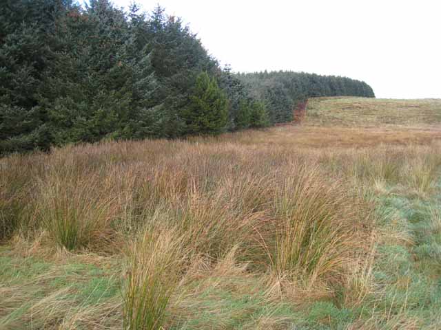
Downs, Moorland in Northumberland

England

St Margaret's Green

Deanmoor Heading south on the A1 (not driving)
Deanmoor Credit: Ray Byrne

St Margaret's Green is a picturesque village located in the Northumberland region of England. Nestled amidst the stunning landscape of downs and moorland, it offers a tranquil and idyllic setting for residents and visitors alike.

The village is known for its charming cottages, many of which date back several centuries, adding to its historical appeal. The architecture in St Margaret's Green is predominantly traditional, with stone buildings and thatched roofs, giving it a quintessential English countryside feel.

Surrounded by vast expanses of downs and moorland, the village provides ample opportunities for outdoor activities. Hiking and walking trails crisscross the surrounding countryside, allowing visitors to take in the breathtaking views of rolling hills and lush greenery. Wildlife enthusiasts will also find plenty to explore, as the area is home to a variety of bird species, including red grouse and curlews.

Despite its rural location, St Margaret's Green is not far from amenities and conveniences. The nearby town offers a range of shops, restaurants, and pubs, ensuring that residents have access to everyday necessities and entertainment options.

The community in St Margaret's Green is tight-knit and welcoming, with a strong sense of pride in their village. Regular events and festivals are held throughout the year, bringing residents together and fostering a sense of community spirit.

In summary, St Margaret's Green is a charming village set amidst the stunning landscape of downs and moorland in Northumberland. With its historical architecture, outdoor activities, and strong community, it is a truly delightful place to live or visit.

If you have any feedback on the listing, please let us know in the comments section below.

St Margaret's Green Images

Images are sourced within 2km of 55.38408/-1.7528834 or Grid Reference NU1510. Thanks to Geograph Open Source API. All images are credited.

Deanmoor Heading south on the A1 (not driving)
Deanmoor
Heading south on the A1 (not driving)
Old Rugley The lane to the A1 passes a side lane to Rugley House and drops past Old Rugley to the valley of the Firth Burn, after which it passes the plantation on the right.
Old Rugley
The lane to the A1 passes a side lane to Rugley House and drops past Old Rugley to the valley of the Firth Burn, after which it passes the plantation on the right.
Farmland south of St Margaret's Farm
Farmland at Freemans Hill
Freemans Hill This farm is sheltering just below the brow of the hill.
Freemans Hill
This farm is sheltering just below the brow of the hill.
St Margaret's Farm This farmhouse occupies a commanding position on Alnwick Moor.
St Margaret's Farm
This farmhouse occupies a commanding position on Alnwick Moor.
Fence and grass moorland on Thorny Knowe The belt of trees in the middle distance is at Freemans Hill <a href="https://www.geograph.org.uk/gridref/NU1508">NU1508</a>. The North Sea can be seen on the horizon.
Fence and grass moorland on Thorny Knowe
The belt of trees in the middle distance is at Freemans Hill NU1508. The North Sea can be seen on the horizon.
Moorland and plantation near Thorny Knowe
Alnwick Moor A summit on the grassy Alnwick Moor (250m) crowned by a trig pillar.
Alnwick Moor
A summit on the grassy Alnwick Moor (250m) crowned by a trig pillar.
Metalled road south of Snipe House The footpath from Snipe House crosses this Metalled road.
Metalled road south of Snipe House
The footpath from Snipe House crosses this Metalled road.
Freemanshill Moor trig OS name for the trig.
Freemanshill Moor trig
OS name for the trig.
Ruined barn at the top of Rugley Road This barn has lost its roof in the last five years - see <a href="https://www.geograph.org.uk/photo/3398706">NU1609 : Farm building / animal shelter</a>. Beyond the Northumbrian countryside stretches down to the sea.
Ruined barn at the top of Rugley Road
This barn has lost its roof in the last five years - see NU1609 : Farm building / animal shelter. Beyond the Northumbrian countryside stretches down to the sea.
Sheep and feeder Near Rugley Cottages.
Sheep and feeder
Near Rugley Cottages.
Trees by the Firth Burn
Field near the Great North Road
Tree beside the road to Whittingham Just off the Great North Road.
Tree beside the road to Whittingham
Just off the Great North Road.
Livestock feeder Beside the road to Whittingham.
Livestock feeder
Beside the road to Whittingham.
Snipe House Farm Cottages and Bungalow
Show me another place!

St Margaret's Green is located at Grid Ref: NU1510 (Lat: 55.38408, Lng: -1.7528834)

Unitary Authority: Northumberland

Police Authority: Northumbria

What 3 Words

///advancing.grant.credited. Near Shilbottle, Northumberland

Nearby Locations

St Margaret's Green

Related Wikis

Camphill Column, Alnwick

The Camphill Column in Alnwick, Northumberland, is a stone column erected in 1814, celebrating a number of British victories over the French and others...

Edlingham railway station

Edlingham railway station served the village of Edlingham, Northumberland, England from 1887 to 1953 on the Cornhill Branch. == History == The station...

The Duchess's Community High School

The Duchess's Community High School is a co-educational secondary school and sixth form located in Alnwick in the English county of Northumberland. It...

Lemmington Hall

Lemmington Hall is an 18th-century country mansion incorporating a 15th-century tower house, situated near Edlingham, Northumberland, England. It is a...

RRH Brizlee Wood

Remote Radar Head Brizlee Wood (or RRH Brizlee Wood), is an air defence radar station operated by the Royal Air Force located at Brizlee Wood, near Alnwick...

Alnwick Town A.F.C.

Alnwick Town Association Football Club is a football club based in Alnwick, Northumberland, England. They are currently members of the Northern Alliance...

Shilbottle

Shilbottle is a village in Northumberland, north-east England, 3 miles (4.8 km) south-east of Alnwick, and 5 miles (8 km) from the coast at Alnmouth, close...
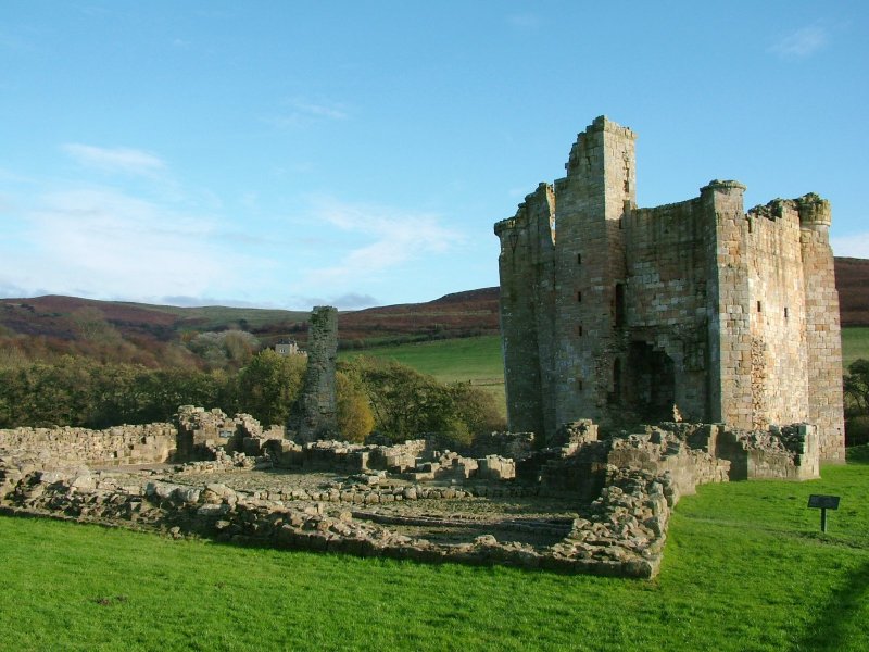
Edlingham Castle

Edlingham Castle is a small castle ruin, having scheduled monument and Grade I listed building status, in the care of English Heritage. It is located in...

Nearby Amenities

Located within 500m of 55.38408,-1.7528834
limekiln (dis)
Building: yes
Lat/Long: 55.3847817/-1.7480209
Power: pole
Source: Bing
Lat/Long: 55.3869926/-1.7527919
Power: pole
Source: Bing
Lat/Long: 55.3865116/-1.748818
Power: pole
Lat/Long: 55.3810361/-1.7550433
Power: pole
Source: Bing
Lat/Long: 55.3866562/-1.75011
Power: pole
Source: Bing
Lat/Long: 55.3864755/-1.7584982
Power: pole
Lat/Long: 55.38105/-1.7542492
Power: pole
Lat/Long: 55.3843505/-1.7525438
Power: pole
Source: Bing
Lat/Long: 55.3868953/-1.754035
Power: pole
Lat/Long: 55.3802624/-1.7537889
Power: pole
Lat/Long: 55.3862676/-1.751684
Power: pole
Source: Bing
Lat/Long: 55.3867785/-1.7552486
Power: pole
Lat/Long: 55.3807325/-1.755536
Power: pole
Source: Bing
Lat/Long: 55.3868258/-1.7514558
Power: pole
Source: Bing
Lat/Long: 55.3863782/-1.7595994
Power: pole
Lat/Long: 55.3853341/-1.7521075
Power: pole
Lat/Long: 55.3798599/-1.7539036
Power: pole
Source: Bing
Lat/Long: 55.38662/-1.7568783
Power: pole
Lat/Long: 55.3822788/-1.7532603
Power: pole
Source: Bing
Lat/Long: 55.3863309/-1.7474526
Power: pole
Source: Bing
Lat/Long: 55.3861892/-1.7461851
Power: pole
Lat/Long: 55.3811716/-1.7535272
The data included in this document is from www.openstreetmap.org. The data is made available under ODbL.

Have you been to St Margaret's Green?

Leave your review of St Margaret's Green below (or comments, questions and feedback).