White Earth

Downs, Moorland in Yorkshire Richmondshire

England

White Earth

Stile near Downholme Bridge The stile gives walkers access to the footpath that takes them initially beside the River Swale before heading west towards Cat Bank and Marske.
Stile near Downholme Bridge Credit: Maigheach-gheal

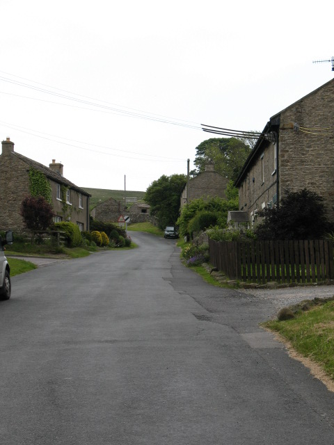
White Earth is a picturesque village located in the heart of Yorkshire, England. Situated on the edge of the beautiful Yorkshire Downs and surrounded by vast moorlands, it offers a serene and idyllic setting for residents and visitors alike.

The village is characterized by its charming stone cottages, dating back several centuries, that dot the landscape. The architecture reflects the traditional Yorkshire style, with their distinctive thatched roofs and quaint gardens. The streets are lined with vibrant flowers and well-maintained hedges, adding to the village's enchanting atmosphere.

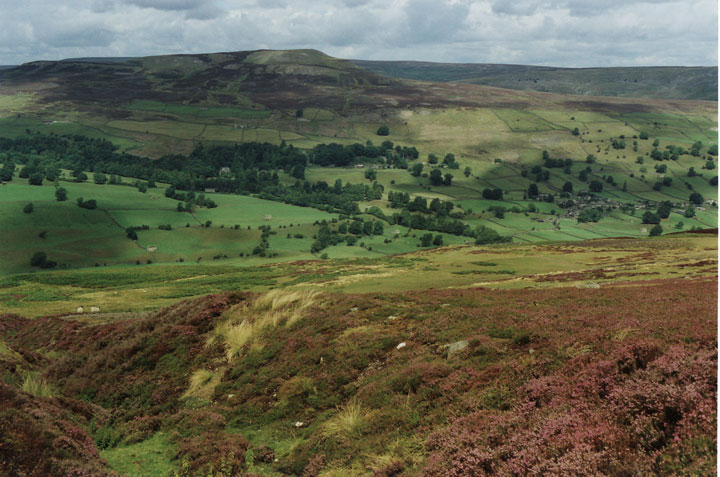
White Earth is known for its stunning natural beauty. The Yorkshire Downs, a short distance from the village, offer breathtaking views of rolling hills and lush green meadows. The moorlands, with their wild and rugged terrain, provide a haven for nature enthusiasts and hikers, with numerous trails to explore.

In the village center, there are a few local shops and amenities catering to the needs of the small but close-knit community. The village pub, The White Horse, is a popular gathering spot for locals and visitors, serving traditional Yorkshire fare and ales.

White Earth is also steeped in history, with several historical landmarks nearby. The ruins of a medieval castle, dating back to the 12th century, can be visited just a short drive away. Additionally, the village church, St. Mary's, is a beautiful example of Gothic architecture and holds regular services for the community.

Overall, White Earth, Yorkshire (Downs, Moorland) offers a perfect blend of natural beauty, historical charm, and a strong sense of community, making it an ideal destination for those seeking a peaceful and picturesque getaway.

If you have any feedback on the listing, please let us know in the comments section below.

White Earth Images

Images are sourced within 2km of 54.383305/-1.824533 or Grid Reference SE1198. Thanks to Geograph Open Source API. All images are credited.

Stile near Downholme Bridge The stile gives walkers access to the footpath that takes them initially beside the River Swale before heading west towards Cat Bank and Marske.
Stile near Downholme Bridge
The stile gives walkers access to the footpath that takes them initially beside the River Swale before heading west towards Cat Bank and Marske.
Downholme Bridge Late 17th century, Grade II listed bridge.  It is built of rubble with ashlar dressings.
Downholme Bridge
Late 17th century, Grade II listed bridge. It is built of rubble with ashlar dressings.
River Swale, Downholme Looking upstream from Downholme Bridge.

The River Swale is the northernmost tributary of the Yorkshire Ouse with its headwaters located in the eastern Yorkshire Dales, from where it flows in an easterly direction towards Richmond.
River Swale, Downholme
Looking upstream from Downholme Bridge. The River Swale is the northernmost tributary of the Yorkshire Ouse with its headwaters located in the eastern Yorkshire Dales, from where it flows in an easterly direction towards Richmond.
River Swale, Downholme Looking downstream from Downholme Bridge.
 
The River Swale is the northernmost tributary of the Yorkshire Ouse with its headwaters located in the eastern Yorkshire Dales, from where it flows in an easterly direction towards Richmond.
River Swale, Downholme
Looking downstream from Downholme Bridge. The River Swale is the northernmost tributary of the Yorkshire Ouse with its headwaters located in the eastern Yorkshire Dales, from where it flows in an easterly direction towards Richmond.
Grazing land, Downholme The field is currently being grazed by sheep, although cattle have also grazed the field recently.  The hay crib is designed to take large round bales.
Grazing land, Downholme
The field is currently being grazed by sheep, although cattle have also grazed the field recently. The hay crib is designed to take large round bales.
Bridleway to Hollins Farm The bridleway heads across grazing fields towards Hollins Farm which is about 1 mile away. Ewes and lambs graze this field.
Bridleway to Hollins Farm
The bridleway heads across grazing fields towards Hollins Farm which is about 1 mile away. Ewes and lambs graze this field.
Footpath near Marske The footpath crosses this small field as it takes walkers towards Low Hollins and Hollins Farm.
Footpath near Marske
The footpath crosses this small field as it takes walkers towards Low Hollins and Hollins Farm.
Gate over the hedge, Marske When the gate is fully open it swings over the dividing hedge of the fields.  The fields are at present being grazed by ewes and lambs.
Gate over the hedge, Marske
When the gate is fully open it swings over the dividing hedge of the fields. The fields are at present being grazed by ewes and lambs.
A6108 near Downholme Church
View of Lower Swaledale The picture was taken close to a newly constructed viewing point on the road which crosses Ministry of Defence land on Downholme Moor.
View of Lower Swaledale
The picture was taken close to a newly constructed viewing point on the road which crosses Ministry of Defence land on Downholme Moor.
Downholme Village Minor roads entering the village from the A6108
Downholme Village
Minor roads entering the village from the A6108
A6108, Downholme village
Cattle Grid, Coldstorms Farm Track leading from A6108 Walburnhead to the farm.
Cattle Grid, Coldstorms Farm
Track leading from A6108 Walburnhead to the farm.
Walburnhead, A6108 Near track to Coldstorms Farm.
Walburnhead, A6108
Near track to Coldstorms Farm.
Fields near Downholme View across sheep grazing land with Gill Beck on the immediate left leading to Swaledale.
Fields near Downholme
View across sheep grazing land with Gill Beck on the immediate left leading to Swaledale.
St. Michael and All Angels Church Near Downholme.
St. Michael and All Angels Church
Near Downholme.
Mole Hills near Downholme Side Bank Wood in the sun.
Mole Hills near Downholme
Side Bank Wood in the sun.
Large Lay by on A6108 Just north of Downholme Bridge
Large Lay by on A6108
Just north of Downholme Bridge
Show me another place!

White Earth is located at Grid Ref: SE1198 (Lat: 54.383305, Lng: -1.824533)

Division: North Riding

Administrative County: North Yorkshire

District: Richmondshire

Police Authority: North Yorkshire

What 3 Words

///folk.alleyway.parsnip. Near Richmond, North Yorkshire

Nearby Locations

White Earth

Related Wikis

Downholme

Downholme is a village and civil parish in North Yorkshire, England. It is situated approximately 4 miles (6 km) west from the market town of Richmond...

Marske, west North Yorkshire

Marske is a village and civil parish in the Richmondshire district of North Yorkshire, England, situated in lower Swaledale on the boundary of the Yorkshire...

Stainton, west North Yorkshire

Stainton is a hamlet and civil parish in the North Yorkshire district of North Yorkshire, England. It is located just outside the Yorkshire Dales National...

Swaledale

Swaledale is a valley in North Yorkshire, England. It is one of the Yorkshire Dales, which are part of the Pennines, and within the Yorkshire Dales National...

Nearby Amenities

Located within 500m of 54.383305,-1.824533
old shaft
Historic: mine_shaft
Source: OS 1:25k
Lat/Long: 54.3812212/-1.825784
old shaft
Historic: mine_shaft
Source: OS 1:25k
Lat/Long: 54.3814086/-1.8241747
old shaft
Historic: mine_shaft
Source: OS 1:25k
Lat/Long: 54.3814336/-1.8237026
Thorn Hill
Natural: peak
Source: OS 1:25k
Lat/Long: 54.3841578/-1.8190892
Downholme Viewing Point
Source: survey
Tourism: viewpoint
Lat/Long: 54.3850182/-1.8210101
The data included in this document is from www.openstreetmap.org. The data is made available under ODbL.

Have you been to White Earth?

Leave your review of White Earth below (or comments, questions and feedback).