Fenny Shaw
Downs, Moorland in Yorkshire
England
Fenny Shaw

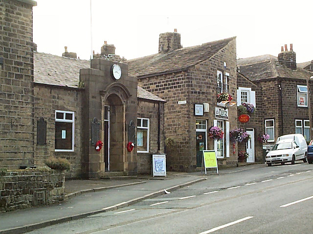
Fenny Shaw is a picturesque village nestled in the heart of Yorkshire, England. Located in the region known as the Yorkshire Downs, the village is surrounded by breathtaking landscapes of rolling green hills and picturesque moorland.
With a population of approximately 500 residents, Fenny Shaw offers a close-knit community feel. The village is known for its friendly locals and warm hospitality, making it an ideal place for those seeking a peaceful and welcoming atmosphere.
The village itself is characterized by its charming architecture, with traditional stone cottages lining the streets. These quaint buildings add to the village's idyllic charm and provide a glimpse into the area's rich history.
Nature enthusiasts will find themselves in heaven in Fenny Shaw. The Yorkshire Downs offer endless opportunities for outdoor activities, such as hiking, cycling, and horseback riding. The moorland, with its vast open spaces and heather-covered hills, provides a stunning backdrop for exploration and relaxation.
Fenny Shaw is also home to a variety of wildlife, including native bird species and small mammals. Nature lovers will appreciate the abundance of wildlife in the area and the opportunity to observe them in their natural habitats.
For those in search of a tranquil retreat, Fenny Shaw is the perfect destination. Its natural beauty, friendly community, and rich history make it a hidden gem in the Yorkshire countryside.
If you have any feedback on the listing, please let us know in the comments section below.
Fenny Shaw Images
Images are sourced within 2km of 53.888542/-1.8285561 or Grid Reference SE1143. Thanks to Geograph Open Source API. All images are credited.


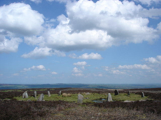
![The Dales Way Link Path, Bingley Moor Rombalds Moor covers about 90 sq.km. between Wharfedale and Airedale. The highest point is 402m above sea level (grid ref for this shared description). Parts of it also have local names referring to the nearest town, e.g. Hawksworth, Burley, Ilkley, Bingley and Morton Moors.
The moor is particularly rich in remains of prehistoric activity. The most numerous relics are the rock carvings which can be found on many of the boulders and outcrops scattered across the moor. Burial monuments stone circles and a range of enclosed settlements are also known. [source: Historic England, overall description covering several ancient monument sites]
There are several small reservoirs, originally built by local authorities, that collect water from the moors. The Rombalds Water Board was taken over by the Yorkshire Water Authority in 1973.](https://s3.geograph.org.uk/geophotos/07/45/24/7452423_0f0ff91f.jpg)
![The Dales Way Link Path, Bingley Moor Rombalds Moor covers about 90 sq.km. between Wharfedale and Airedale. The highest point is 402m above sea level (grid ref for this shared description). Parts of it also have local names referring to the nearest town, e.g. Hawksworth, Burley, Ilkley, Bingley and Morton Moors.
The moor is particularly rich in remains of prehistoric activity. The most numerous relics are the rock carvings which can be found on many of the boulders and outcrops scattered across the moor. Burial monuments stone circles and a range of enclosed settlements are also known. [source: Historic England, overall description covering several ancient monument sites]
There are several small reservoirs, originally built by local authorities, that collect water from the moors. The Rombalds Water Board was taken over by the Yorkshire Water Authority in 1973.](https://s3.geograph.org.uk/geophotos/07/45/24/7452427_2dc81e07.jpg)
![An old milestone, The Dales Way Link Path, Bingley Moor Rombalds Moor covers about 90 sq.km. between Wharfedale and Airedale. The highest point is 402m above sea level (grid ref for this shared description). Parts of it also have local names referring to the nearest town, e.g. Hawksworth, Burley, Ilkley, Bingley and Morton Moors.
The moor is particularly rich in remains of prehistoric activity. The most numerous relics are the rock carvings which can be found on many of the boulders and outcrops scattered across the moor. Burial monuments stone circles and a range of enclosed settlements are also known. [source: Historic England, overall description covering several ancient monument sites]
There are several small reservoirs, originally built by local authorities, that collect water from the moors. The Rombalds Water Board was taken over by the Yorkshire Water Authority in 1973.](https://s1.geograph.org.uk/geophotos/07/45/24/7452433_063b5374.jpg)
![The Dales Way Link Path, Bingley Moor Rombalds Moor covers about 90 sq.km. between Wharfedale and Airedale. The highest point is 402m above sea level (grid ref for this shared description). Parts of it also have local names referring to the nearest town, e.g. Hawksworth, Burley, Ilkley, Bingley and Morton Moors.
The moor is particularly rich in remains of prehistoric activity. The most numerous relics are the rock carvings which can be found on many of the boulders and outcrops scattered across the moor. Burial monuments stone circles and a range of enclosed settlements are also known. [source: Historic England, overall description covering several ancient monument sites]
There are several small reservoirs, originally built by local authorities, that collect water from the moors. The Rombalds Water Board was taken over by the Yorkshire Water Authority in 1973.](https://s0.geograph.org.uk/geophotos/07/45/25/7452592_ea0f6617.jpg)
![The Dales Way Link Path, Bingley Moor Rombalds Moor covers about 90 sq.km. between Wharfedale and Airedale. The highest point is 402m above sea level (grid ref for this shared description). Parts of it also have local names referring to the nearest town, e.g. Hawksworth, Burley, Ilkley, Bingley and Morton Moors.
The moor is particularly rich in remains of prehistoric activity. The most numerous relics are the rock carvings which can be found on many of the boulders and outcrops scattered across the moor. Burial monuments stone circles and a range of enclosed settlements are also known. [source: Historic England, overall description covering several ancient monument sites]
There are several small reservoirs, originally built by local authorities, that collect water from the moors. The Rombalds Water Board was taken over by the Yorkshire Water Authority in 1973.](https://s3.geograph.org.uk/geophotos/07/45/25/7452595_cffd0921.jpg)
![The Dales Way Link Path, Bingley Moor Rombalds Moor covers about 90 sq.km. between Wharfedale and Airedale. The highest point is 402m above sea level (grid ref for this shared description). Parts of it also have local names referring to the nearest town, e.g. Hawksworth, Burley, Ilkley, Bingley and Morton Moors.
The moor is particularly rich in remains of prehistoric activity. The most numerous relics are the rock carvings which can be found on many of the boulders and outcrops scattered across the moor. Burial monuments stone circles and a range of enclosed settlements are also known. [source: Historic England, overall description covering several ancient monument sites]
There are several small reservoirs, originally built by local authorities, that collect water from the moors. The Rombalds Water Board was taken over by the Yorkshire Water Authority in 1973.](https://s1.geograph.org.uk/geophotos/07/45/25/7452597_f4ff21ee.jpg)
![Sign on The Dales Way Link Path, Bingley Moor Rombalds Moor covers about 90 sq.km. between Wharfedale and Airedale. The highest point is 402m above sea level (grid ref for this shared description). Parts of it also have local names referring to the nearest town, e.g. Hawksworth, Burley, Ilkley, Bingley and Morton Moors.
The moor is particularly rich in remains of prehistoric activity. The most numerous relics are the rock carvings which can be found on many of the boulders and outcrops scattered across the moor. Burial monuments stone circles and a range of enclosed settlements are also known. [source: Historic England, overall description covering several ancient monument sites]
There are several small reservoirs, originally built by local authorities, that collect water from the moors. The Rombalds Water Board was taken over by the Yorkshire Water Authority in 1973.](https://s2.geograph.org.uk/geophotos/07/45/25/7452598_ba53c921.jpg)
![The Dales Way Link Path, Ilkley Moor Rombalds Moor covers about 90 sq.km. between Wharfedale and Airedale. The highest point is 402m above sea level (grid ref for this shared description). Parts of it also have local names referring to the nearest town, e.g. Hawksworth, Burley, Ilkley, Bingley and Morton Moors.
The moor is particularly rich in remains of prehistoric activity. The most numerous relics are the rock carvings which can be found on many of the boulders and outcrops scattered across the moor. Burial monuments stone circles and a range of enclosed settlements are also known. [source: Historic England, overall description covering several ancient monument sites]
There are several small reservoirs, originally built by local authorities, that collect water from the moors. The Rombalds Water Board was taken over by the Yorkshire Water Authority in 1973.](https://s0.geograph.org.uk/geophotos/07/45/26/7452600_a3c0ec68.jpg)
![The Dales Way Link Path, Ilkley Moor Rombalds Moor covers about 90 sq.km. between Wharfedale and Airedale. The highest point is 402m above sea level (grid ref for this shared description). Parts of it also have local names referring to the nearest town, e.g. Hawksworth, Burley, Ilkley, Bingley and Morton Moors.
The moor is particularly rich in remains of prehistoric activity. The most numerous relics are the rock carvings which can be found on many of the boulders and outcrops scattered across the moor. Burial monuments stone circles and a range of enclosed settlements are also known. [source: Historic England, overall description covering several ancient monument sites]
There are several small reservoirs, originally built by local authorities, that collect water from the moors. The Rombalds Water Board was taken over by the Yorkshire Water Authority in 1973.](https://s1.geograph.org.uk/geophotos/07/45/26/7452601_7cdf4210.jpg)
![Old milestone by The Dales Way Link Path, Ilkley Moor Rombalds Moor covers about 90 sq.km. between Wharfedale and Airedale. The highest point is 402m above sea level (grid ref for this shared description). Parts of it also have local names referring to the nearest town, e.g. Hawksworth, Burley, Ilkley, Bingley and Morton Moors.
The moor is particularly rich in remains of prehistoric activity. The most numerous relics are the rock carvings which can be found on many of the boulders and outcrops scattered across the moor. Burial monuments stone circles and a range of enclosed settlements are also known. [source: Historic England, overall description covering several ancient monument sites]
There are several small reservoirs, originally built by local authorities, that collect water from the moors. The Rombalds Water Board was taken over by the Yorkshire Water Authority in 1973.](https://s0.geograph.org.uk/geophotos/07/45/26/7452604_e0e72c75.jpg)
![The Dales Way Link Path, Ilkley Moor Rombalds Moor covers about 90 sq.km. between Wharfedale and Airedale. The highest point is 402m above sea level (grid ref for this shared description). Parts of it also have local names referring to the nearest town, e.g. Hawksworth, Burley, Ilkley, Bingley and Morton Moors.
The moor is particularly rich in remains of prehistoric activity. The most numerous relics are the rock carvings which can be found on many of the boulders and outcrops scattered across the moor. Burial monuments stone circles and a range of enclosed settlements are also known. [source: Historic England, overall description covering several ancient monument sites]
There are several small reservoirs, originally built by local authorities, that collect water from the moors. The Rombalds Water Board was taken over by the Yorkshire Water Authority in 1973.](https://s2.geograph.org.uk/geophotos/07/45/26/7452606_2060094a.jpg)
![The Dales Way Link Path, Ilkley Moor Rombalds Moor covers about 90 sq.km. between Wharfedale and Airedale. The highest point is 402m above sea level (grid ref for this shared description). Parts of it also have local names referring to the nearest town, e.g. Hawksworth, Burley, Ilkley, Bingley and Morton Moors.
The moor is particularly rich in remains of prehistoric activity. The most numerous relics are the rock carvings which can be found on many of the boulders and outcrops scattered across the moor. Burial monuments stone circles and a range of enclosed settlements are also known. [source: Historic England, overall description covering several ancient monument sites]
There are several small reservoirs, originally built by local authorities, that collect water from the moors. The Rombalds Water Board was taken over by the Yorkshire Water Authority in 1973.](https://s2.geograph.org.uk/geophotos/07/45/29/7452982_847dad42.jpg)
Fenny Shaw is located at Grid Ref: SE1143 (Lat: 53.888542, Lng: -1.8285561)
Division: West Riding
Unitary Authority: Bradford
Police Authority: West Yorkshire
What 3 Words
///pots.likewise.conductor. Near Ilkley, West Yorkshire
Nearby Locations
Related Wikis

Keighley (UK Parliament constituency)
Keighley is a constituency in West Yorkshire created in 1885 represented in the House of Commons of the UK Parliament since 2019 by Robbie Moore of the...
East Morton
East Morton is a small village which lies 2 miles (3 km) north of Bingley and 2.5 miles (4 km) east of Keighley, in the county of West Yorkshire, England...

Welcome Way
The Welcome Way is a 36-mile (58 km) walking route in West Yorkshire, England. It connects Otley, Baildon, Burley in Wharfedale and Bingley, and takes...
Twelve Apostles, West Yorkshire
The Twelve Apostles (grid reference SE12614506) is a stone circle near Ilkley and Burley in Wharfedale in West Yorkshire, England. == Location == Located...
Nearby Amenities
Located within 500m of 53.888542,-1.8285561Have you been to Fenny Shaw?
Leave your review of Fenny Shaw below (or comments, questions and feedback).