Addingham Middle Moor

Downs, Moorland in Yorkshire

England

Addingham Middle Moor

Back Beck Lane is closed But not to walkers. At the junction with Sugar Hill on the northern edge of Addingham.
Back Beck Lane is closed Credit: Christine Johnstone

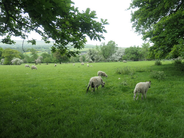
Addingham Middle Moor is a picturesque expanse of moorland located in the county of Yorkshire, England. Situated in the beautiful Yorkshire Dales National Park, it covers an area of approximately 2.5 square miles and sits at an elevation of around 300 meters above sea level.

The moorland is characterized by its rolling hills, heather-covered slopes, and vibrant wildlife. It offers breathtaking panoramic views of the surrounding countryside, with distant hills and valleys stretching as far as the eye can see. The area is also intersected by several small streams and dotted with patches of woodland, adding to its natural charm.

Addingham Middle Moor is a haven for nature enthusiasts and birdwatchers. It is home to a variety of bird species, including curlews, lapwings, and red grouse, which thrive in its open, heather-rich habitats. Visitors can often spot these birds as they soar through the skies or catch glimpses of them nesting among the moorland vegetation.

The moorland is crisscrossed by a network of footpaths and bridleways, making it a popular destination for walkers and hikers. It offers a range of routes catering to different abilities, from gentle strolls to challenging treks. Exploring the moorland on foot allows visitors to immerse themselves in the serene surroundings, breathe in the fresh air, and experience the tranquility of the Yorkshire countryside.

Addingham Middle Moor is a true gem within Yorkshire's natural landscape, offering a unique combination of stunning vistas, diverse wildlife, and opportunities for outdoor recreation. Its unspoiled beauty and peaceful ambiance make it an ideal destination for those seeking a retreat into nature.

If you have any feedback on the listing, please let us know in the comments section below.

Addingham Middle Moor Images

Images are sourced within 2km of 53.935861/-1.9095936 or Grid Reference SE0648. Thanks to Geograph Open Source API. All images are credited.

Back Beck Lane is closed But not to walkers. At the junction with Sugar Hill on the northern edge of Addingham.
Back Beck Lane is closed
But not to walkers. At the junction with Sugar Hill on the northern edge of Addingham.
Long Riddings, Addingham The white markers warn of a 30cm or more drop into a ditch, hidden by the plants alongside the concrete. This lane is marked and named on the large-scale OS map surveyed in 1850.
Long Riddings, Addingham
The white markers warn of a 30cm or more drop into a ditch, hidden by the plants alongside the concrete. This lane is marked and named on the large-scale OS map surveyed in 1850.
Wooded farmland near Walker Acre Just north of Addingham, at the northern edge of Bradford MDC and West Yorkshire.
Wooded farmland near Walker Acre
Just north of Addingham, at the northern edge of Bradford MDC and West Yorkshire.
Sheep and lambs, south of Riddings Farm The sheep has been shorn very recently.
Sheep and lambs, south of Riddings Farm
The sheep has been shorn very recently.
High Laithe, from the north This farm building is shown on the large-scale OS map surveyed in 1850. It is now next to Bracken Ghyll golf course [founded 1993].
High Laithe, from the north
This farm building is shown on the large-scale OS map surveyed in 1850. It is now next to Bracken Ghyll golf course [founded 1993].
Boundary marker, Addingham Low Moor Not lettered or numbered, but on the boundary between Addingham and Silsden civil parishes. Just within Bradford metropolitan district, the boundary of which runs along the first wall beyond the stone.
Boundary marker, Addingham Low Moor
Not lettered or numbered, but on the boundary between Addingham and Silsden civil parishes. Just within Bradford metropolitan district, the boundary of which runs along the first wall beyond the stone.
On the gentle summit of Counter Hill Looking north-east past Chelker reservoir. At 290 metres, this is a local high point, with fine views in most directions. No wonder that the land around the summit is full of prehistoric earthworks <a href="https://www.geograph.org.uk/photo/7621648">SE0549 : Prehistoric earthwork below Counter Hill</a> <a href="https://www.geograph.org.uk/photo/7622540">SE0550 : Round Dikes, Counter Hill, east side</a>.
On the gentle summit of Counter Hill
Looking north-east past Chelker reservoir. At 290 metres, this is a local high point, with fine views in most directions. No wonder that the land around the summit is full of prehistoric earthworks SE0549 : Prehistoric earthwork below Counter Hill SE0550 : Round Dikes, Counter Hill, east side.
Sheep on the summit of Counter Hill Looking towards Beamsley Beacon. At 290 metres, this is a local high point, with fine views in most directions. No wonder that the land around the summit is full of prehistoric earthworks <a href="https://www.geograph.org.uk/photo/7621648">SE0549 : Prehistoric earthwork below Counter Hill</a> <a href="https://www.geograph.org.uk/photo/7622540">SE0550 : Round Dikes, Counter Hill, east side</a>.
Sheep on the summit of Counter Hill
Looking towards Beamsley Beacon. At 290 metres, this is a local high point, with fine views in most directions. No wonder that the land around the summit is full of prehistoric earthworks SE0549 : Prehistoric earthwork below Counter Hill SE0550 : Round Dikes, Counter Hill, east side.
Round Dikes, Counter Hill, north-west side A large oval Iron Age enclosure, one of many prehistoric earthworks around this hill.
Round Dikes, Counter Hill, north-west side
A large oval Iron Age enclosure, one of many prehistoric earthworks around this hill.
Round Dikes, Counter Hill, north-east side A large oval Iron Age enclosure, one of many prehistoric earthworks around this hill.
Round Dikes, Counter Hill, north-east side
A large oval Iron Age enclosure, one of many prehistoric earthworks around this hill.
Round Dikes, Counter Hill, east side A large oval Iron Age enclosure, one of many prehistoric earthworks around this hill.
Round Dikes, Counter Hill, east side
A large oval Iron Age enclosure, one of many prehistoric earthworks around this hill.
'A solitary wooden signpost in the middle of the field' Landmark on Addingham Low Moor. Quoted from Don Barrett's 'Walk 8: Pre-Historic Addingham'.
'A solitary wooden signpost in the middle of the field'
Landmark on Addingham Low Moor. Quoted from Don Barrett's 'Walk 8: Pre-Historic Addingham'.
Step stile on a drystone wall On Addingham Low Moor, east of Counter Hill.
Step stile on a drystone wall
On Addingham Low Moor, east of Counter Hill.
Public footpath to Addingham Low Moor Near High Cross Bank. Work stopped as we passed.
Public footpath to Addingham Low Moor
Near High Cross Bank. Work stopped as we passed.
Ruined field barn, north of Cross Bank The barn is shown on the large scale OS map surveyed in 1850.
Ruined field barn, north of Cross Bank
The barn is shown on the large scale OS map surveyed in 1850.
Boundary Stone on Addingham Low Moor On top of a small hill, offering splendid views across Wharfedale towards Beamsley Beacon
Boundary Stone on Addingham Low Moor
On top of a small hill, offering splendid views across Wharfedale towards Beamsley Beacon
Jumble of Rocks, Boulders and Stones on Addingham Low Moor I dont know whether this is a natural formation or a jumble of stones gathered from a redundant dry stone wall
Jumble of Rocks, Boulders and Stones on Addingham Low Moor
I dont know whether this is a natural formation or a jumble of stones gathered from a redundant dry stone wall
A65 just north of Addingham
Show me another place!

Addingham Middle Moor is located at Grid Ref: SE0648 (Lat: 53.935861, Lng: -1.9095936)

Division: West Riding

Unitary Authority: Bradford

Police Authority: West Yorkshire

What 3 Words

///scarves.searching.live. Near Addingham, West Yorkshire

Related Wikis

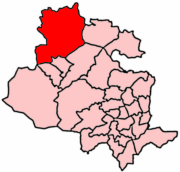
Craven (Bradford ward)

Craven is an electoral ward within the City of Bradford Metropolitan District Council, West Yorkshire, England. The population of the ward at the 2011...

Addingham

Addingham (formerly Haddincham c. 972, Odingehem 1086) is a village and civil parish in the City of Bradford in West Yorkshire, England. It is situated...

Addingham railway station

Addingham railway station was on the Midland Railway route from Skipton to Ilkley. It served the village of Addingham in West Yorkshire, England. ��2...

St Peter's Church, Addingham

St Peter's Church is a Church of England parish church in Addingham, West Yorkshire. It is a Grade I listed building, with the main structure dating to...

Nearby Amenities

Located within 500m of 53.935861,-1.9095936
Delf Hill
Natural: peak
Source: OS 1:25k
Lat/Long: 53.9351243/-1.9130521
Addingham Middle Moor
Natural: moor
Source: OS OpenData StreetView
Lat/Long: 53.9374123/-1.9132673
Power: pole
Source: Bing
Lat/Long: 53.9376288/-1.9096202
Power: pole
Source: Bing
Lat/Long: 53.9381594/-1.908215
Power: pole
Source: Bing
Lat/Long: 53.9366057/-1.914357
Power: pole
Source: Bing
Lat/Long: 53.9382905/-1.912171
Power: pole
Source: Bing
Lat/Long: 53.9398235/-1.9120154
Power: pole
Source: Bing
Lat/Long: 53.9391067/-1.9120664
Building: trailer
Roof Colour: white
Roof Levels: 1
Roof Material: metal
Roof Shape: flat
Lat/Long: 53.9368361/-1.906299
Building: garage
Lat/Long: 53.9370668/-1.9064069
Bench
Backrest: yes
Lat/Long: 53.9370203/-1.9060599
Building: house
Building Levels: 1
Building Use: leisure
Height: 3
Roof Colour: brown
Lat/Long: 53.9367372/-1.9061174
Street Lamp
Lamp Type: flood light
Lat/Long: 53.9372308/-1.9062867
Natural: water
Water: basin
Lat/Long: 53.9372068/-1.9059854
Camera Mount: wall
Camera Type: fixed
Man Made: surveillance
Surveillance: outdoor
Surveillance Type: camera
Surveillance Zone: building
Lat/Long: 53.937107/-1.9062047
Street Lamp
Addr Street: small road
Lat/Long: 53.9372123/-1.9063121
The data included in this document is from www.openstreetmap.org. The data is made available under ODbL.

Have you been to Addingham Middle Moor?

Leave your review of Addingham Middle Moor below (or comments, questions and feedback).