Appletreewick Pasture

Downs, Moorland in Yorkshire Craven

England

Appletreewick Pasture

Burnsall Bridge, from the south Burnsall Bridge, Burnsall, North Yorkshire, taken from beside the car park on the south side of the village.
Burnsall Bridge, from the south Credit: Carroll Pierce

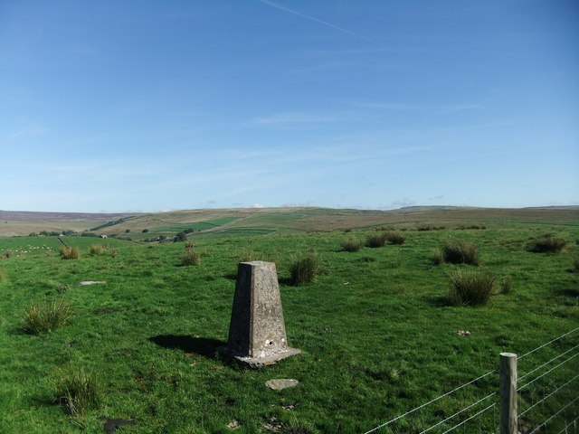
Appletreewick Pasture is a picturesque area located in Yorkshire, England. Nestled in between the stunning Yorkshire Downs and Moorland, this landscape is a haven for nature lovers and outdoor enthusiasts.

The pasture itself is a vast expanse of rolling green fields, dotted with ancient oak trees and bordered by dry-stone walls. The land is fertile, providing grazing grounds for local livestock, including sheep and cows. It is not uncommon to see these animals peacefully grazing, adding to the idyllic charm of the area.

Surrounding the pasture are the majestic Yorkshire Downs, with their gentle slopes and panoramic views. These hills are popular among hikers and walkers, who come to explore the numerous trails that crisscross the landscape. From the top, one can enjoy breathtaking vistas of the surrounding countryside, with its patchwork of fields and charming villages.

To the north of the pasture lies the vast moorland, with its rugged terrain and heather-covered hills. This area is home to a variety of wildlife, including grouse, curlews, and even the occasional deer. It is a popular spot for birdwatching and nature photography.

Appletreewick Pasture is not only a place of natural beauty but also has a rich history. The nearby village of Appletreewick itself dates back centuries, with its quaint stone cottages and historic church. Visitors can explore the local pubs and tea rooms, enjoying traditional Yorkshire fare and soaking up the relaxed atmosphere.

In conclusion, Appletreewick Pasture is a captivating destination that offers a harmonious blend of stunning landscapes, abundant wildlife, and rich history. Whether it's for a leisurely stroll, a challenging hike, or simply a moment of tranquility, this Yorkshire gem is sure to leave a lasting impression.

If you have any feedback on the listing, please let us know in the comments section below.

Appletreewick Pasture Images

Images are sourced within 2km of 54.053982/-1.9162424 or Grid Reference SE0562. Thanks to Geograph Open Source API. All images are credited.

Burnsall Bridge, from the south Burnsall Bridge, Burnsall, North Yorkshire, taken from beside the car park on the south side of the village.
Burnsall Bridge, from the south
Burnsall Bridge, Burnsall, North Yorkshire, taken from beside the car park on the south side of the village.
Langerton Hill Trig Pillar
Field footpath near Hartlington
B6265 east of Dibble's Bridge The road descends to cross the River Dibb before approaching Hebden.
B6265 east of Dibble's Bridge
The road descends to cross the River Dibb before approaching Hebden.
The Craven arms. The best pub in Appletreewick.
The Craven arms.
The best pub in Appletreewick.
The Church of St John the Baptist at Appletreewick Viewed from the south.
The Church of St John the Baptist at Appletreewick
Viewed from the south.
The Craven Arms and Cruck Barn
Sheep shelter among logs near a dew pond Dew pond on right of view seen on path up to Troller's Gill
Sheep shelter among logs near a dew pond
Dew pond on right of view seen on path up to Troller's Gill
Hartlington Hall viewed from Kail Lane
Track over Appletreewick pasture View towards the south
Track over Appletreewick pasture
View towards the south
The track nears the top of Appletreewick pasture
The stile for the path to Skyreholme The path leads past Troller's Gill
The stile for the path to Skyreholme
The path leads past Troller's Gill
The path to Skyreholme A lead mine can be seen in distance
The path to Skyreholme
A lead mine can be seen in distance
Old lead mine workings on path to Skyreholme
The path to Skyreholme near Trollers Gill
Parcevall Hall Gardens tea room Viewed from path beside Skyreholme Beck to Trollers Gill,
Parcevall Hall Gardens tea room
Viewed from path beside Skyreholme Beck to Trollers Gill,
Stone cottage at Skyreholme
Burnsall Primary School This is the Grade II listed primary school at Burnsall, North Yorkshire <span class="nowrap"><a title="https://en.wikipedia.org/wiki/Burnsall" rel="nofollow ugc noopener" href="https://en.wikipedia.org/wiki/Burnsall">Link</a><img style="margin-left:2px;" alt="External link" title="External link - shift click to open in new window" src="https://s1.geograph.org.uk/img/external.png" width="10" height="10"/></span> . Langerton Hill rises up across the River Wharfe beyond.
Burnsall Primary School
This is the Grade II listed primary school at Burnsall, North Yorkshire LinkExternal link . Langerton Hill rises up across the River Wharfe beyond.
Show me another place!

Appletreewick Pasture is located at Grid Ref: SE0562 (Lat: 54.053982, Lng: -1.9162424)

Division: West Riding

Administrative County: North Yorkshire

District: Craven

Police Authority: North Yorkshire

What 3 Words

///pile.compliant.claw. Near Grassington, North Yorkshire

Nearby Locations

Appletreewick Pasture

Related Wikis

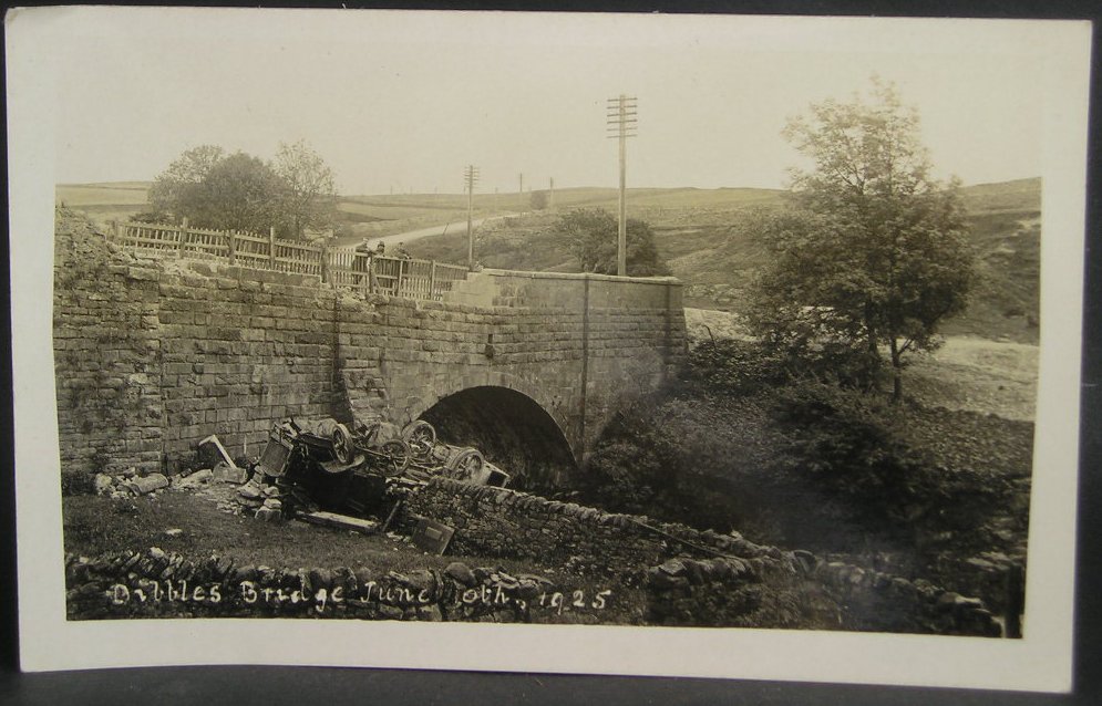
1925 Dibbles Bridge coach crash

On 10 June 1925, a coach crashed at the bottom of a steep hill at Dibbles Bridge, near Hebden in North Yorkshire, England. Seven people were killed and...

1975 Dibbles Bridge coach crash

On 27 May 1975, a coach carrying elderly passengers crashed at the bottom of a steep hill at Dibble's Bridge, near Hebden in North Yorkshire, England....

Trollers Gill

Trollers Gill is a limestone gill or gorge in North Yorkshire, England, close to the village of Skyreholme and 4.7 miles (7.5 km) south-east of Grassington...

Parcevall Hall

Parcevall Hall -- also known as Parceval Hall -- and its gardens are located at Skyreholme near Appletreewick village, Wharfedale, North Yorkshire, England...

Skyreholme

Skyreholme is a hamlet in Wharfedale in the Yorkshire Dales, North Yorkshire, England. It lies 1-mile (1.6 km) east of Appletreewick, in the small side...

Hartlington

Hartlington is a small village and civil parish in the Craven district of North Yorkshire, England. At the 2011 Census, the population of the parish was...

Appletreewick

Appletreewick is a village and civil parish in the Craven district of North Yorkshire, England, 6.5 miles (10.5 km) north-east of Skipton, 7 miles (11...

River Dibb

The River Dibb, also known as Barben Beck, is a small river located in North Yorkshire, England. It is a tributary of the River Wharfe. Grimwith Reservoir...

Nearby Amenities

Located within 500m of 54.053982,-1.9162424
Appletreewick Pasture
Natural: fell
Source: npe
Lat/Long: 54.0545754/-1.9111306
Historic: mine_shaft
Source: Bing
Lat/Long: 54.0520082/-1.9167278
Historic: mine_shaft
Source: Bing
Lat/Long: 54.0531641/-1.9150433
Historic: mine_shaft
Source: Bing
Lat/Long: 54.0520556/-1.9157997
Historic: mine_shaft
Source: Bing
Lat/Long: 54.0557935/-1.921427
Historic: mine_shaft
Source: Bing
Lat/Long: 54.0561619/-1.9209657
Historic: mine_shaft
Source: Bing
Lat/Long: 54.0551182/-1.9205907
Historic: mine_shaft
Source: Bing
Lat/Long: 54.0525563/-1.9188092
Historic: mine_shaft
Source: Bing
Lat/Long: 54.0542694/-1.9155476
Historic: mine_shaft
Source: Bing
Lat/Long: 54.0537561/-1.9158587
Historic: mine_shaft
Source: Bing
Lat/Long: 54.0545308/-1.9152418
Historic: mine_shaft
Source: Bing
Lat/Long: 54.053904/-1.9158534
Historic: mine_shaft
Source: Bing
Lat/Long: 54.052254/-1.9158534
Historic: mine_shaft
Source: Bing
Lat/Long: 54.0550365/-1.922656
Historic: mine_shaft
Source: Bing
Lat/Long: 54.0517753/-1.9154188
Historic: mine_shaft
Source: Bing
Lat/Long: 54.0524209/-1.9157568
Historic: mine_shaft
Source: Bing
Lat/Long: 54.0545465/-1.9163683
Historic: mine_shaft
Source: Bing
Lat/Long: 54.0553968/-1.9145391
Historic: mine_shaft
Source: Bing
Lat/Long: 54.0548791/-1.9213041
Historic: mine_shaft
Source: Bing
Lat/Long: 54.051876/-1.9157944
Historic: mine_shaft
Source: Bing
Lat/Long: 54.0551371/-1.9215455
Historic: mine_shaft
Source: Bing
Lat/Long: 54.0537719/-1.9152311
Historic: mine_shaft
Source: Bing
Lat/Long: 54.0521342/-1.9165025
Historic: mine_shaft
Source: Bing
Lat/Long: 54.0540994/-1.9157407
Historic: mine_shaft
Mineral: lead
Source: Bing
Lat/Long: 54.0549986/-1.9134715
Historic: mine_shaft
Source: Bing
Lat/Long: 54.0535312/-1.9154992
Historic: mine_shaft
Source: Bing
Lat/Long: 54.0547212/-1.9136539
Historic: mine_shaft
Source: Bing
Lat/Long: 54.0541484/-1.9159718
Historic: mine_shaft
Source: Bing
Lat/Long: 54.0532663/-1.9155636
Historic: mine_shaft
Mineral: lead
Source: Bing
Lat/Long: 54.0526368/-1.9136753
Historic: mine_shaft
Source: Bing
Lat/Long: 54.0535878/-1.9147589
Historic: mine_shaft
Source: Bing
Lat/Long: 54.053317/-1.9151774
Historic: mine_shaft
Source: Bing
Lat/Long: 54.0529577/-1.915231
Historic: mine_shaft
Source: Bing
Lat/Long: 54.0534304/-1.9155421
Historic: mine_shaft
Source: Bing
Lat/Long: 54.0543937/-1.9123128
Historic: mine_shaft
Mineral: lead
Source: Bing
Lat/Long: 54.0531715/-1.9087186
Historic: mine_shaft
Source: Bing
Lat/Long: 54.0531341/-1.9144907
Historic: mine_shaft
Source: Bing
Lat/Long: 54.0537642/-1.9113686
Historic: mine_shaft
Source: Bing
Lat/Long: 54.0517106/-1.9145873
Historic: mine_shaft
Source: Bing
Lat/Long: 54.0514149/-1.9136646
Historic: mine_shaft
Source: Bing
Lat/Long: 54.0535375/-1.9126668
Historic: mine_shaft
Source: Bing
Lat/Long: 54.0527565/-1.909534
Historic: mine_shaft
Source: Bing
Lat/Long: 54.0514212/-1.9159504
Historic: mine_shaft
Source: Bing
Lat/Long: 54.0535878/-1.9132676
Historic: mine_shaft
Source: Bing
Lat/Long: 54.0520319/-1.9106069
Historic: mine_shaft
Mineral: lead
Source: Bing
Lat/Long: 54.0546837/-1.9132033
Historic: mine_shaft
Mineral: lead
Source: Bing
Lat/Long: 54.053386/-1.9088259
Historic: mine_shaft
Source: Bing
Lat/Long: 54.0515784/-1.9136861
Historic: mine_shaft
Source: Bing
Lat/Long: 54.0542428/-1.9160684
Historic: mine_shaft
Mineral: lead
Source: Bing
Lat/Long: 54.0545637/-1.9128278
Historic: mine_shaft
Source: Bing
Lat/Long: 54.053972/-1.9159397
Historic: mine_shaft
Source: Bing
Lat/Long: 54.0538461/-1.9136002
Historic: mine_shaft
Mineral: lead
Source: Bing
Lat/Long: 54.0549167/-1.9138792
Historic: mine_shaft
Source: Bing
Lat/Long: 54.0523846/-1.9125703
Historic: mine_shaft
Source: Bing
Lat/Long: 54.0526242/-1.9145444
Historic: mine_shaft
Source: Bing
Lat/Long: 54.05195/-1.9129887
Historic: mine_shaft
Source: Bing
Lat/Long: 54.053676/-1.9154027
Historic: mine_shaft
Source: Bing
Lat/Long: 54.0522526/-1.9099953
Historic: mine_shaft
Source: Bing
Lat/Long: 54.0544696/-1.9138899
Historic: mine_shaft
Source: Bing
Lat/Long: 54.0543688/-1.9162401
Historic: mine_shaft
Mineral: lead
Source: Bing
Lat/Long: 54.0546333/-1.9130209
Historic: mine_shaft
Source: Bing
Lat/Long: 54.0541106/-1.9137719
Historic: mine_shaft
Source: Bing
Lat/Long: 54.051163/-1.912817
Historic: mine_shaft
Source: Bing
Lat/Long: 54.0535689/-1.9156065
Historic: mine_shaft
Source: Bing
Lat/Long: 54.0547593/-1.9137933
Historic: mine_shaft
Source: Bing
Lat/Long: 54.0530966/-1.9154349
Historic: mine_shaft
Source: Bing
Lat/Long: 54.053386/-1.9149091
Historic: mine_shaft
Source: Bing
Lat/Long: 54.0526368/-1.915113
Historic: mine_shaft
Source: Bing
Lat/Long: 54.0522715/-1.913096
Historic: mine_shaft
Source: Bing
Lat/Long: 54.0531533/-1.9146624
Historic: mine_shaft
Source: Bing
Lat/Long: 54.0529139/-1.9142118
Historic: mine_shaft
Source: Bing
Lat/Long: 54.0527877/-1.9152203
Historic: mine_shaft
Source: Bing
Lat/Long: 54.0515595/-1.9154885
Historic: mine_shaft
Source: Bing
Lat/Long: 54.0517106/-1.9155314
Historic: mine_shaft
Mineral: lead
Source: Bing
Lat/Long: 54.0532789/-1.9087615
Historic: mine_shaft
Source: Bing
Lat/Long: 54.0533674/-1.9104352
Historic: mine_shaft
Source: Bing
Lat/Long: 54.053676/-1.9111755
Historic: mine_shaft
Mineral: lead
Source: Bing
Lat/Long: 54.0544822/-1.9124415
Historic: mine_shaft
Mineral: lead
Source: Bing
Lat/Long: 54.0544885/-1.9125917
Historic: mine_shaft
Source: Bing
Lat/Long: 54.0537135/-1.9110682
Historic: mine_shaft
Source: Bing
Lat/Long: 54.0532348/-1.9153383
Historic: mine_shaft
Source: Bing
Lat/Long: 54.0540347/-1.9150486
Historic: mine_shaft
Source: Bing
Lat/Long: 54.0513959/-1.9145873
Historic: mine_shaft
Source: Bing
Lat/Long: 54.0514998/-1.915054
Historic: mine_shaft
Source: Bing
Lat/Long: 54.0517736/-1.9158747
Historic: mine_shaft
Source: Bing
Lat/Long: 54.0534838/-1.914834
Historic: mine_shaft
Source: Bing
Lat/Long: 54.0546521/-1.9142279
Historic: mine_shaft
Source: Bing
Lat/Long: 54.0521076/-1.9129511
Historic: mine_shaft
Source: Bing
Lat/Long: 54.0523123/-1.9124308
Historic: mine_shaft
Source: Bing
Lat/Long: 54.050218/-1.9181388
Historic: mine_shaft
Source: Bing
Lat/Long: 54.0514965/-1.9165241
Historic: mine_shaft
Source: Bing
Lat/Long: 54.0530931/-1.9186109
Historic: mine_shaft
Source: Bing
Lat/Long: 54.053175/-1.913332
Historic: mine_shaft
Source: Bing
Lat/Long: 54.051698/-1.9163363
Historic: mine_shaft
Source: Bing
Lat/Long: 54.0553291/-1.9160145
Historic: mine_shaft
Source: Bing
Lat/Long: 54.0520602/-1.9127526
Historic: mine_shaft
Source: Bing
Lat/Long: 54.0520005/-1.9126936
Historic: mine_shaft
Source: Bing
Lat/Long: 54.0528128/-1.9138148
Historic: mine_shaft
Source: Bing
Lat/Long: 54.0512164/-1.9189166
Historic: mine_shaft
Source: Bing
Lat/Long: 54.0562956/-1.9152954
Historic: mine_shaft
Source: Bing
Lat/Long: 54.0556786/-1.9156172
Historic: mine_shaft
Source: Bing
Lat/Long: 54.0514746/-1.9167601
Historic: mine_shaft
Source: Bing
Lat/Long: 54.0514998/-1.9170659
Historic: mine_shaft
Source: Bing
Lat/Long: 54.0530585/-1.9185519
Historic: mine_shaft
Source: Bing
Lat/Long: 54.052901/-1.9143512
Historic: mine_shaft
Source: Bing
Lat/Long: 54.0531592/-1.91264
Historic: mine_shaft
Source: Bing
Lat/Long: 54.0558674/-1.9164007
Historic: mine_shaft
Source: Bing
Lat/Long: 54.0514839/-1.9169962
Historic: mine_shaft
Source: Bing
Lat/Long: 54.0531939/-1.9114169
Historic: mine_shaft
Source: Bing
Lat/Long: 54.0515061/-1.9171464
Historic: mine_shaft
Source: Bing
Lat/Long: 54.0567207/-1.9165187
Historic: mine_shaft
Source: Bing
Lat/Long: 54.054334/-1.9142654
Historic: mine_shaft
Source: Bing
Lat/Long: 54.0516414/-1.9161754
Historic: mine_shaft
Source: Bing
Lat/Long: 54.0544253/-1.9142386
Historic: mine_shaft
Source: Bing
Lat/Long: 54.0522052/-1.9140294
Historic: mine_shaft
Source: Bing
Lat/Long: 54.0520572/-1.9129672
Historic: mine_shaft
Source: Bing
Lat/Long: 54.0522745/-1.9148448
Historic: mine_shaft
Source: Bing
Lat/Long: 54.0532444/-1.9121733
Historic: mine_shaft
Source: Bing
Lat/Long: 54.0553858/-1.9154992
Historic: mine_shaft
Source: Bing
Lat/Long: 54.05679/-1.9164007
Historic: mine_shaft
Source: Bing
Lat/Long: 54.0525924/-1.9128546
Historic: mine_shaft
Source: Bing
Lat/Long: 54.0520856/-1.914834
Historic: mine_shaft
Source: Bing
Lat/Long: 54.0532348/-1.9134071
Historic: mine_shaft
Source: Bing
Lat/Long: 54.0569569/-1.9162183
Historic: mine_shaft
Source: Bing
Lat/Long: 54.0509769/-1.9187986
Historic: mine_shaft
Source: Bing
Lat/Long: 54.0545322/-1.9142225
Historic: mine_shaft
Source: Bing
Lat/Long: 54.0568815/-1.9162934
Historic: mine_shaft
Source: Bing
Lat/Long: 54.0524194/-1.9129189
Historic: mine_shaft
Source: Bing
Lat/Long: 54.0516382/-1.9164705
Historic: mine_shaft
Source: Bing
Lat/Long: 54.0519186/-1.9165831
Historic: mine_shaft
Source: Bing
Lat/Long: 54.0516856/-1.9166528
Historic: mine_shaft
Source: Bing
Lat/Long: 54.0527563/-1.912581
Historic: mine_shaft
Source: Bing
Lat/Long: 54.0524697/-1.9146248
Historic: mine_shaft
Source: Bing
Lat/Long: 54.0531216/-1.9125113
Historic: mine_shaft
Source: Bing
Lat/Long: 54.055496/-1.9157245
Historic: mine_shaft
Source: Bing
Lat/Long: 54.0556281/-1.9163042
Historic: mine_shaft
Source: Bing
Lat/Long: 54.0522995/-1.9128224
Historic: mine_shaft
Source: Bing
Lat/Long: 54.0518177/-1.9169264
Historic: mine_shaft
Source: Bing
Lat/Long: 54.0526806/-1.9127848
Historic: mine_shaft
Source: Bing
Lat/Long: 54.0558361/-1.9159072
Historic: mine_shaft
Source: Bing
Lat/Long: 54.0532317/-1.9188898
Historic: mine_shaft
Source: Bing
Lat/Long: 54.0545732/-1.9151559
Historic: mine_shaft
Source: Bing
Lat/Long: 54.0522052/-1.9148072
Historic: mine_shaft
Source: Bing
Lat/Long: 54.0543183/-1.915113
Historic: mine_shaft
Source: Bing
Lat/Long: 54.0534806/-1.9128599
Historic: mine_shaft
Source: Bing
Lat/Long: 54.0522525/-1.9146195
Historic: mine_shaft
Source: Bing
Lat/Long: 54.0535593/-1.9148877
Historic: mine_shaft
Source: Bing
Lat/Long: 54.0516825/-1.9168942
Historic: mine_shaft
Source: Bing
Lat/Long: 54.0550646/-1.9148931
Historic: mine_shaft
Source: Bing
Lat/Long: 54.0505898/-1.9116798
The data included in this document is from www.openstreetmap.org. The data is made available under ODbL.

Have you been to Appletreewick Pasture?

Leave your review of Appletreewick Pasture below (or comments, questions and feedback).