Kilnsey Park
Downs, Moorland in Yorkshire Craven
England
Kilnsey Park

Kilnsey Park is a picturesque and scenic destination located in the heart of Yorkshire, England. Nestled amidst the stunning Yorkshire Downs and Moorland, it offers visitors a unique blend of natural beauty, outdoor activities, and educational experiences.
The park is renowned for its idyllic setting, with rolling hills and lush greenery stretching as far as the eye can see. It is a haven for nature lovers and outdoor enthusiasts, with an abundance of walking trails and cycling routes that allow visitors to explore the surrounding countryside. The park's diverse ecosystem is home to a wide range of flora and fauna, making it a popular spot for wildlife enthusiasts.
One of the main attractions of Kilnsey Park is its well-stocked fishing lakes. Anglers flock to the park to try their luck at catching trout, with both beginners and experienced fishermen catered for. The park also offers fishing lessons and equipment hire, ensuring that everyone can enjoy this popular pastime.
For those seeking a more educational experience, Kilnsey Park boasts a nature trail and a discovery trail, both offering interactive and informative displays about the local environment and wildlife. Visitors can learn about the area's geological history, explore its diverse habitats, and even try their hand at fossil hunting.
The park also features a charming café and a farm shop, where visitors can indulge in delicious homemade food and purchase locally sourced produce. The café boasts panoramic views of the surrounding countryside, providing the perfect setting for a relaxing meal or a cup of tea.
Overall, Kilnsey Park offers a delightful escape from the hustle and bustle of everyday life, allowing visitors to immerse themselves in the natural beauty of the Yorkshire Downs and Moorland.
If you have any feedback on the listing, please let us know in the comments section below.
Kilnsey Park Images
Images are sourced within 2km of 54.105403/-2.0415793 or Grid Reference SD9767. Thanks to Geograph Open Source API. All images are credited.

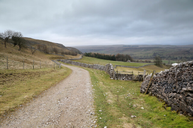
![A walk from Grassington to Kelber and return [51] Now known as Scot Gate Lane, the track descends steeply between rock outcrops.
After leaving the town, the walk crosses Grassington Moor via Bare House to Bycliffe Road. The road is followed past Kelber Gate towards Scot Gate Lane. The route then follows the long distance Dales Way back to Grassington. About 6½ miles.](https://s3.geograph.org.uk/geophotos/07/03/78/7037875_896b4227.jpg)
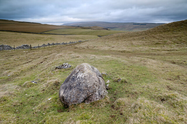
![A walk from Grassington to Kelber and return [52] A view of the incised and eroded small valley known as Dib, seen from the track.
After leaving the town, the walk crosses Grassington Moor via Bare House to Bycliffe Road. The road is followed past Kelber Gate towards Scot Gate Lane. The route then follows the long distance Dales Way back to Grassington. About 6½ miles.](https://s0.geograph.org.uk/geophotos/07/03/78/7037876_80188cca.jpg)
![A walk from Grassington to Kelber and return [53] At this point a footpath, part of the long distance Dales Way, crosses the bridleway, Scot Gate Lane.
After leaving the town, the walk crosses Grassington Moor via Bare House to Bycliffe Road. The road is followed past Kelber Gate towards Scot Gate Lane. The route then follows the long distance Dales Way back to Grassington. About 6½ miles.](https://s2.geograph.org.uk/geophotos/07/03/78/7037878_8684a2a0.jpg)
![A walk from Grassington to Kelber and return [54] From the junction, this footpath, part of the long distance Dales Way, heads towards Grassington.
After leaving the town, the walk crosses Grassington Moor via Bare House to Bycliffe Road. The road is followed past Kelber Gate towards Scot Gate Lane. The route then follows the long distance Dales Way back to Grassington. About 6½ miles.](https://s0.geograph.org.uk/geophotos/07/03/78/7037880_65d87271.jpg)
![A walk from Grassington to Kelber and return [55] There is a small stone flag bridge over a rivulet. Just beyond the gate, a footpath branches off to the right to descend into the incised valley known as Dib.
After leaving the town, the walk crosses Grassington Moor via Bare House to Bycliffe Road. The road is followed past Kelber Gate towards Scot Gate Lane. The route then follows the long distance Dales Way back to Grassington. About 6½ miles.](https://s1.geograph.org.uk/geophotos/07/03/78/7037881_13f3d565.jpg)
![A walk from Grassington to Kelber and return [56] A view down the incised valley known as Dib. Seen from the footpath.
After leaving the town, the walk crosses Grassington Moor via Bare House to Bycliffe Road. The road is followed past Kelber Gate towards Scot Gate Lane. The route then follows the long distance Dales Way back to Grassington. About 6½ miles.](https://s2.geograph.org.uk/geophotos/07/03/78/7037882_2711e8ca.jpg)
![A walk from Grassington to Kelber and return [57] The footpath, part of the long distance Dales Way, heads across the moorland towards Grassington.
After leaving the town, the walk crosses Grassington Moor via Bare House to Bycliffe Road. The road is followed past Kelber Gate towards Scot Gate Lane. The route then follows the long distance Dales Way back to Grassington. About 6½ miles.](https://s3.geograph.org.uk/geophotos/07/03/78/7037883_24940df1.jpg)
![A walk from Grassington to Kelber and return [58] Two footpaths cross at this point. The paths lead to Scot Gate Lane, Conistone, Bare House and Grassington.
After leaving the town, the walk crosses Grassington Moor via Bare House to Bycliffe Road. The road is followed past Kelber Gate towards Scot Gate Lane. The route then follows the long distance Dales Way back to Grassington. About 6½ miles.](https://s1.geograph.org.uk/geophotos/07/03/78/7037889_a8e1b32e.jpg)
![A walk from Grassington to Kelber and return [59] Two footpaths cross at this point. The paths lead to Scot Gate Lane, Conistone, Bare House and Grassington. This is the path to Scot Gate Lane.
After leaving the town, the walk crosses Grassington Moor via Bare House to Bycliffe Road. The road is followed past Kelber Gate towards Scot Gate Lane. The route then follows the long distance Dales Way back to Grassington. About 6½ miles.](https://s0.geograph.org.uk/geophotos/07/03/78/7037892_d686b27a.jpg)
![A walk from Grassington to Kelber and return [60] Two footpaths cross at this point. The paths lead to Scot Gate Lane, Conistone, Bare House and Grassington. This is the path to Conistone.
After leaving the town, the walk crosses Grassington Moor via Bare House to Bycliffe Road. The road is followed past Kelber Gate towards Scot Gate Lane. The route then follows the long distance Dales Way back to Grassington. About 6½ miles.](https://s1.geograph.org.uk/geophotos/07/03/78/7037893_52c6e732.jpg)
![A walk from Grassington to Kelber and return [62] Two footpaths cross at this point. The paths lead to Scot Gate Lane, Conistone, Bare House and Grassington. This is the path, part of the long distance Dales Way, towards Grassington.
After leaving the town, the walk crosses Grassington Moor via Bare House to Bycliffe Road. The road is followed past Kelber Gate towards Scot Gate Lane. The route then follows the long distance Dales Way back to Grassington. About 6½ miles.](https://s3.geograph.org.uk/geophotos/07/03/78/7037895_d67962c5.jpg)


Kilnsey Park is located at Grid Ref: SD9767 (Lat: 54.105403, Lng: -2.0415793)
Division: West Riding
Administrative County: North Yorkshire
District: Craven
Police Authority: North Yorkshire
What 3 Words
///pausing.blog.petrified. Near Grassington, North Yorkshire
Nearby Locations
Related Wikis
Kilnsey
Kilnsey is a small village in Wharfedale, North Yorkshire, England. It lies on the B6160 road, between the villages of Grassington and Kettlewell, near...

St Mary's Church, Conistone
St Mary's Church is in the village of Conistone, North Yorkshire, England. It is an active Anglican parish church in the deanery of Skipton, the archdeaconry...

Conistone
Conistone is a small village in the Craven district of North Yorkshire, England. It lies 3 miles (5 km) north of Grassington, 3 miles (5 km) south of Kettlewell...

Conistone with Kilnsey
Conistone with Kilnsey is a civil parish in Wharfedale in the district of Craven, North Yorkshire, England. It contains the villages of Kilnsey and Conistone...
Nearby Amenities
Located within 500m of 54.105403,-2.0415793Have you been to Kilnsey Park?
Leave your review of Kilnsey Park below (or comments, questions and feedback).