Dale Head Common

Downs, Moorland in Yorkshire Richmondshire

England

Dale Head Common

Eroding sandstone on Scargill High Moor The prominent escarpment  at the top of Scargill High Moor is formed in the unnamed sandstone that lies just below the Little Limestone, towards the bottom of the Stainmore Group, of Pendleian age in the Carboniferous. It's part of what older ones among us will remember as being the Millstone Grit series. At the top of the slope, blocks of sandstone are weathering out, and have little or no peat drift covering them. Just back from the edge, a path links lines of grouse butts, making for surprisingly easy and pleasant walking. Even beyond the last grouse butt (some way to the west) the path continues as a gamekeeper's access, somewhat narrower but still giving mostly easy footing.
Eroding sandstone on Scargill High Moor Credit: Andy Waddington

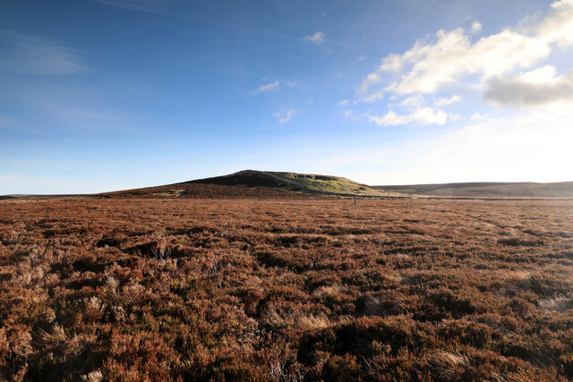
Dale Head Common is a picturesque expanse of land located in the county of Yorkshire, England. Nestled within the Yorkshire Dales, this common offers visitors a unique mix of stunning downs and moorland landscapes. Covering an area of approximately 500 acres, Dale Head Common is a haven for nature enthusiasts and outdoor adventurers alike.

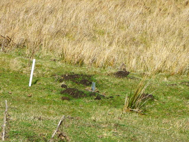
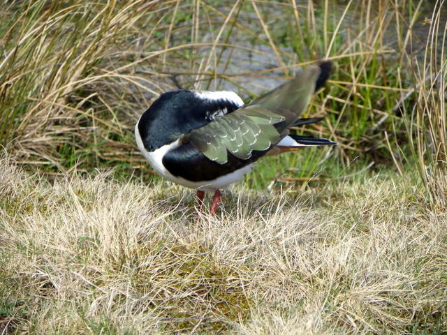
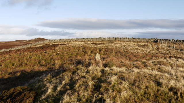
The common is characterized by its rolling hills, lush green pastures, and heather-covered moorlands. These diverse habitats provide a home to a wide array of plant and animal species, making it a popular destination for wildlife enthusiasts. Visitors may spot iconic species such as red grouse, curlew, and lapwing, as well as a variety of wildflowers and mosses.

Dale Head Common boasts several walking trails that meander through its captivating landscapes. These paths offer breathtaking views of the surrounding countryside, including the nearby Wharfedale and Nidderdale valleys. The common also provides ample opportunities for birdwatching, photography, and picnicking.

For those seeking a more immersive experience, camping is permitted in designated areas, allowing visitors to spend a night under the starry Yorkshire sky. However, it is important to note that open fires are strictly prohibited to protect the delicate ecosystems.

Dale Head Common is easily accessible by car, with a nearby parking area available for visitors. The common is open year-round, though the best time to visit is during the summer months when the landscape is in full bloom. Whether one seeks solitude in nature, a scenic walk, or a chance to observe wildlife, Dale Head Common offers a quintessential Yorkshire experience.

If you have any feedback on the listing, please let us know in the comments section below.

Dale Head Common Images

Images are sourced within 2km of 54.466641/-2.0502782 or Grid Reference NY9607. Thanks to Geograph Open Source API. All images are credited.

Eroding sandstone on Scargill High Moor The prominent escarpment  at the top of Scargill High Moor is formed in the unnamed sandstone that lies just below the Little Limestone, towards the bottom of the Stainmore Group, of Pendleian age in the Carboniferous. It's part of what older ones among us will remember as being the Millstone Grit series. At the top of the slope, blocks of sandstone are weathering out, and have little or no peat drift covering them. Just back from the edge, a path links lines of grouse butts, making for surprisingly easy and pleasant walking. Even beyond the last grouse butt (some way to the west) the path continues as a gamekeeper's access, somewhat narrower but still giving mostly easy footing.
Eroding sandstone on Scargill High Moor
The prominent escarpment at the top of Scargill High Moor is formed in the unnamed sandstone that lies just below the Little Limestone, towards the bottom of the Stainmore Group, of Pendleian age in the Carboniferous. It's part of what older ones among us will remember as being the Millstone Grit series. At the top of the slope, blocks of sandstone are weathering out, and have little or no peat drift covering them. Just back from the edge, a path links lines of grouse butts, making for surprisingly easy and pleasant walking. Even beyond the last grouse butt (some way to the west) the path continues as a gamekeeper's access, somewhat narrower but still giving mostly easy footing.
North towards Citron Seat From the Gilmonby road, a bridleway heads south as a good track, and where it splits, the branch to Citron Seat (the small dark-topped hill right on centre in this view) continues very clear, though, like the southern branch, it ends very abruptly at no particularly obvious destination (just at a change of local authority administering the definitive rights of way map). The southern branch passes through this view just at the foot of the slope, though you'd hardly know it. Since it terminates abruptly at the boundary wall and fails to enter the Yorkshire Dales National park, its original destination is unclear, but somewhere in upper Arkengarthdale seems likely, perhaps joining the public footpath which also started life as a bridleway until it hit the National Park frontier. One suspects some severe laxity in recording the rights of way after the 1949 Countryside Act.
North towards Citron Seat
From the Gilmonby road, a bridleway heads south as a good track, and where it splits, the branch to Citron Seat (the small dark-topped hill right on centre in this view) continues very clear, though, like the southern branch, it ends very abruptly at no particularly obvious destination (just at a change of local authority administering the definitive rights of way map). The southern branch passes through this view just at the foot of the slope, though you'd hardly know it. Since it terminates abruptly at the boundary wall and fails to enter the Yorkshire Dales National park, its original destination is unclear, but somewhere in upper Arkengarthdale seems likely, perhaps joining the public footpath which also started life as a bridleway until it hit the National Park frontier. One suspects some severe laxity in recording the rights of way after the 1949 Countryside Act.
Tarnhow Hill Although apparently a very minor eminence on the map, Tarnhow Hill seems quite prominent across the otherwise rather flat bit of moorland above Bleakhow Edge (itself a rather over-grandiose name for a short steep slope with a few sandstone boulders). There's a small crag or perhaps a quarry, which I would have guessed was formed in the Little Limestone, but BGS sheet 41 (Kirkby Stephen) shows it as Richmond Chert, a little above the limestone. It also shows Tarnhow Hill covered in drift with no actual bedrock showing, which is clearly not the case, so I withhold judgement on which bed is outcropping, as I suspect that the mappers, like myself today, may not have trekked over to the hill and examined it in detail. The drystone wall which crosses its shoulder, marks the post-1974 border between North Yorkshire and County Durham (prior to that, the boundary was along the River Tees, further north) and is also the frontier of the Yorkshire Dales National Park. A number of rights of way either change status to lesser rights, or terminate abruptly on that border, suggesting that within the Park (in 1949 it was all the North Riding) recording of existing paths was far more lax than outside on the definitive map. Given the time it took for the 1949 Act to result in these definitive maps, it is possible that the discrepancy lay between the post-1974 county authorities.
Tarnhow Hill
Although apparently a very minor eminence on the map, Tarnhow Hill seems quite prominent across the otherwise rather flat bit of moorland above Bleakhow Edge (itself a rather over-grandiose name for a short steep slope with a few sandstone boulders). There's a small crag or perhaps a quarry, which I would have guessed was formed in the Little Limestone, but BGS sheet 41 (Kirkby Stephen) shows it as Richmond Chert, a little above the limestone. It also shows Tarnhow Hill covered in drift with no actual bedrock showing, which is clearly not the case, so I withhold judgement on which bed is outcropping, as I suspect that the mappers, like myself today, may not have trekked over to the hill and examined it in detail. The drystone wall which crosses its shoulder, marks the post-1974 border between North Yorkshire and County Durham (prior to that, the boundary was along the River Tees, further north) and is also the frontier of the Yorkshire Dales National Park. A number of rights of way either change status to lesser rights, or terminate abruptly on that border, suggesting that within the Park (in 1949 it was all the North Riding) recording of existing paths was far more lax than outside on the definitive map. Given the time it took for the 1949 Act to result in these definitive maps, it is possible that the discrepancy lay between the post-1974 county authorities.
Sheep grazing land, White Hill This area of upland grazing is made up of rough grasses.  The white stick in the lower left hand corner of the image indicates the presence of a mole trap.
Sheep grazing land, White Hill
This area of upland grazing is made up of rough grasses. The white stick in the lower left hand corner of the image indicates the presence of a mole trap.
Mole trap, White Hill There two main types of mole trap available on the British market, the scissor trap and the tunnel trap (also known as the half tunnel or Duffus Trap, after its inventor).  For a wider view <a href="https://www.geograph.org.uk/photo/2402173">NY9606 : Sheep grazing land, White Hill</a>.
Mole trap, White Hill
There two main types of mole trap available on the British market, the scissor trap and the tunnel trap (also known as the half tunnel or Duffus Trap, after its inventor). For a wider view NY9606 : Sheep grazing land, White Hill.
Bridleway, Leading Stead Bottom The bridleway takes riders and walkers across Leading Stead Bottom towards Coney Seat Hill.
Bridleway, Leading Stead Bottom
The bridleway takes riders and walkers across Leading Stead Bottom towards Coney Seat Hill.
Preening Lapwing, Leading Stead Bottom Lapwing (Vanellus vanellus)

This broad-winged bird of damp field, ploughed land and damp moorland flickers black and white in flight.  On the ground it runs and stops to tilt forward, then run on again, searching for insects and larvae, its call is a mournful 'peewit'.
Preening Lapwing, Leading Stead Bottom
Lapwing (Vanellus vanellus) This broad-winged bird of damp field, ploughed land and damp moorland flickers black and white in flight. On the ground it runs and stops to tilt forward, then run on again, searching for insects and larvae, its call is a mournful 'peewit'.
Lapwing (Vanellus vanellus) Lapwings (often known as peewits, due to their distinctive, plaintive 'peewit' calls) are one of our handsome birds, and the exuberant aerobatics of their nuptial flights are an exhilarating spring spectacle.  Although by nature a wader of wetlands, lapwings now nest in a variety of other habitats, including moorland.
Lapwing (Vanellus vanellus)
Lapwings (often known as peewits, due to their distinctive, plaintive 'peewit' calls) are one of our handsome birds, and the exuberant aerobatics of their nuptial flights are an exhilarating spring spectacle. Although by nature a wader of wetlands, lapwings now nest in a variety of other habitats, including moorland.
Lapwing (Vanellus vanellus) Lapwing eggs are pear-shaped and the nest may be hidden among grass, crops or furrows.  This particular bird is enjoying a good preen.
Lapwing (Vanellus vanellus)
Lapwing eggs are pear-shaped and the nest may be hidden among grass, crops or furrows. This particular bird is enjoying a good preen.
Lapwing (Vanellus vanellus) The lapwing has many local names, reflecting the affection with which they are held by many – Pee Wit, Pie Wipe, Toppyup,  and Peasiewheep are among them.

In British folklore they have a dark reputation. One legend says they flew over the cross crying 'Pine Him! Pine Him!' (Make him suffer) and were cursed for this.

In Scotland their call is said to have betrayed persecuted Covenanters, hiding out on the moors.
Lapwing (Vanellus vanellus)
The lapwing has many local names, reflecting the affection with which they are held by many – Pee Wit, Pie Wipe, Toppyup, and Peasiewheep are among them. In British folklore they have a dark reputation. One legend says they flew over the cross crying 'Pine Him! Pine Him!' (Make him suffer) and were cursed for this. In Scotland their call is said to have betrayed persecuted Covenanters, hiding out on the moors.
Lapwing (Vanellus vanellus) The wader has a long crest and is apparently black and white, but on closer inspection the black is metallic green with black markings, and the legs are reddish. It has a relatively slow flapping flight but is capable of great aerobatics particularly in breeding season.
Lapwing (Vanellus vanellus)
The wader has a long crest and is apparently black and white, but on closer inspection the black is metallic green with black markings, and the legs are reddish. It has a relatively slow flapping flight but is capable of great aerobatics particularly in breeding season.
Sheepfold, Leading Stead Bottom The circular pound is a sheepfold.
Sheepfold, Leading Stead Bottom
The circular pound is a sheepfold.
Boundary stone on Stony Hill The boundary stone in the centre of the image has a white-painted letter B on the face towards the camera. It's one of a series of similar stones along a fence line running generally south-west and seen at the right side of the image; this stone is unusual in being located off the fence line. At the wall/fence junction in view there's a boulder embedded in the ground bearing a chiselled letter B. The conical hill to the left side of the photograph is Citron Seat.
Boundary stone on Stony Hill
The boundary stone in the centre of the image has a white-painted letter B on the face towards the camera. It's one of a series of similar stones along a fence line running generally south-west and seen at the right side of the image; this stone is unusual in being located off the fence line. At the wall/fence junction in view there's a boulder embedded in the ground bearing a chiselled letter B. The conical hill to the left side of the photograph is Citron Seat.
Gate in fence south of Charity Pasture The image was recorded close to the most northerly point of the Yorkshire Dales National Park; in fact the park begins at the fence and lies on the other side of it. The gate allows the passage of a bridleway through the fence to ground on the camera side known as Charity Pasture - extremely wet! Cleasby Hill is the rise beyond the gate.
Gate in fence south of Charity Pasture
The image was recorded close to the most northerly point of the Yorkshire Dales National Park; in fact the park begins at the fence and lies on the other side of it. The gate allows the passage of a bridleway through the fence to ground on the camera side known as Charity Pasture - extremely wet! Cleasby Hill is the rise beyond the gate.
Fence corner at Bow Hills Low emminences qualify for naming as hills in this part of the Yorkshire Dales National Park. Bow Hills are very minor affairs, as is Stony Hill which is the rise seen along the fence line. (Stony Hill is in fact the most northerly point of the national park, the fence line here being the boundary itself.) Citron Seat is the conical hill on the skyline left of Stony Hill; it lies outside the national park.
Fence corner at Bow Hills
Low emminences qualify for naming as hills in this part of the Yorkshire Dales National Park. Bow Hills are very minor affairs, as is Stony Hill which is the rise seen along the fence line. (Stony Hill is in fact the most northerly point of the national park, the fence line here being the boundary itself.) Citron Seat is the conical hill on the skyline left of Stony Hill; it lies outside the national park.
Footpath to Coney Seat Hill There is no footpath but a direct line will take you to the bridge over Beck Crooks.
Footpath to Coney Seat Hill
There is no footpath but a direct line will take you to the bridge over Beck Crooks.
Bridge over Beck Crooks
Ancient bridge over one of the feeders to Arkle Beck
Show me another place!

Dale Head Common is located at Grid Ref: NY9607 (Lat: 54.466641, Lng: -2.0502782)

Division: North Riding

Administrative County: North Yorkshire

District: Richmondshire

Police Authority: North Yorkshire

What 3 Words

///comply.working.orange. Near Bowes, Co. Durham

Related Wikis

Sleightholme

Sleightholme is a secluded hamlet on a dead end road in County Durham, England. It lies beside Sleightholme Beck, a tributary of the River Greta. The...

Walney to Wear and Whitby Cycle Route

The Walney to Wear and Whitby Cycle Route (or W2W) is the name of a cross-country cycle route in Northern England. It runs from Walney Island in Cumbria...

National Cycle Route 70

National Cycle Network (NCN) Route 70 is a Sustrans National Route that runs from Walney Island in Cumbria to Sunderland. The route is fully open and signed...

Whaw

Whaw is a hamlet in Arkengarthdale in North Yorkshire, England. It is one of few settlements in the dale and is one of the smallest. Its name derives from...

Have you been to Dale Head Common?

Leave your review of Dale Head Common below (or comments, questions and feedback).