Winterings Moss

Downs, Moorland in Yorkshire Richmondshire

England

Winterings Moss

Old Rake Hush Relic of the long dead lead mining industry that once thrived in this location. The use of damming up water and releasing it violently, to strip away vegetation and scour land to reveal the ore beneath.
The Coast to Coast Walk runs parallel to this feature.
Old Rake Hush Credit: Chris Heaton

Winterings Moss is a captivating and picturesque area located in the scenic region of Yorkshire, England. Nestled amidst the stunning Yorkshire Downs and Moorland, this tranquil landscape offers a unique blend of natural beauty and rich history.

The moss is characterized by its vast expanse of rolling meadows, heather-covered hills, and scattered patches of dense woodland. The area experiences a typically cold and wet climate during winter, enhancing its enchanting allure. Snow blankets the landscape, transforming it into a winter wonderland, while frost delicately adorns the branches of trees, creating a magical atmosphere.

The moss is home to a diverse array of wildlife, including various species of birds, mammals, and insects. Birdwatchers flock to the area to catch a glimpse of the resident species, such as red grouse, curlews, and golden plovers. The moorland also supports a rich population of sheep, which graze peacefully on the lush grasslands.

The history of Winterings Moss is deeply rooted in the region's heritage. Ancient archaeological remains, like burial mounds and stone circles, provide evidence of human habitation in the area dating back thousands of years. These historical sites attract archaeology enthusiasts and history buffs alike.

Visitors to Winterings Moss can enjoy a range of outdoor activities, including hiking, cycling, and photography. The area boasts an extensive network of well-maintained trails that lead adventurers through the captivating landscape, offering breathtaking views of the surrounding countryside.

In conclusion, Winterings Moss is a captivating destination that showcases the natural beauty and rich history of Yorkshire. Its picturesque scenery, diverse wildlife, and abundance of outdoor activities make it a must-visit location for nature enthusiasts and history lovers alike.

If you have any feedback on the listing, please let us know in the comments section below.

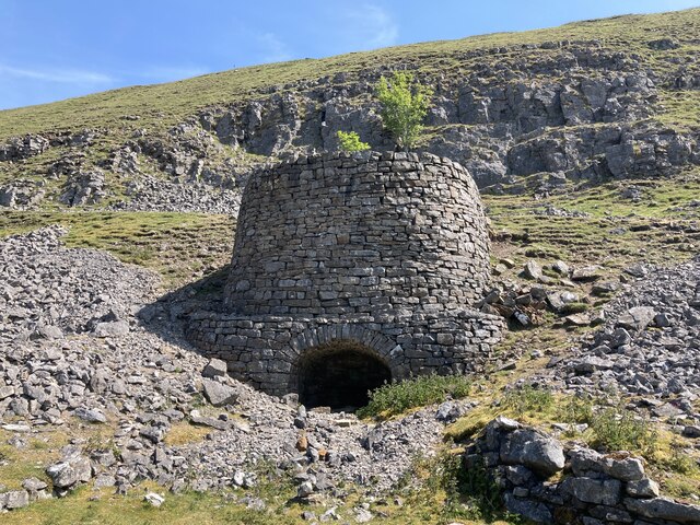
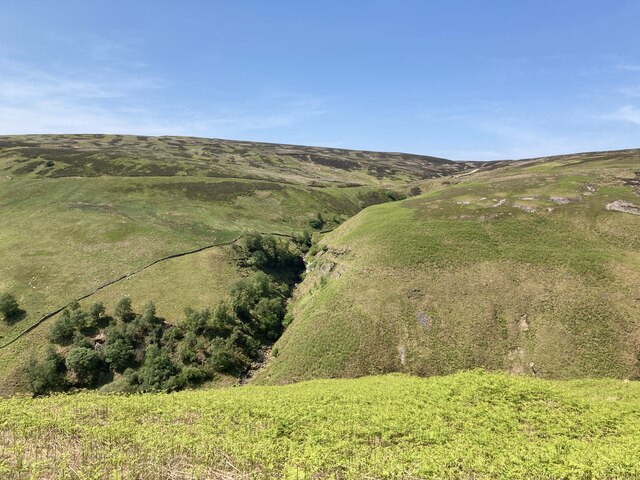
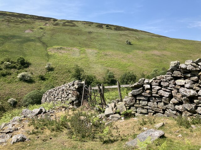
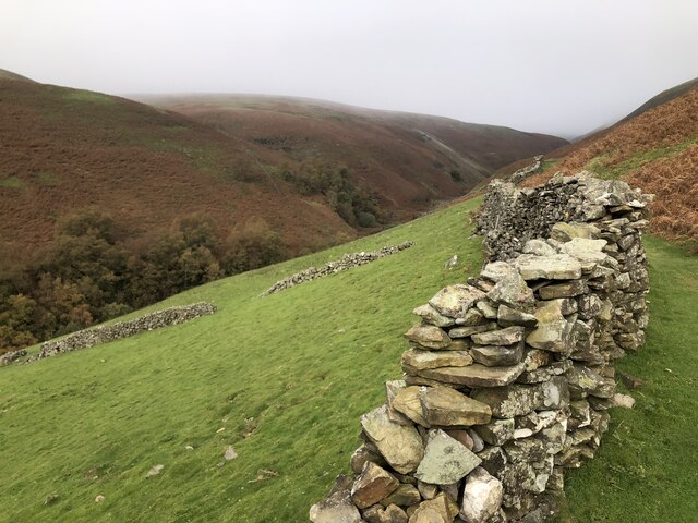
Winterings Moss Images

Images are sourced within 2km of 54.396022/-2.0826582 or Grid Reference NY9400. Thanks to Geograph Open Source API. All images are credited.

Old Rake Hush Relic of the long dead lead mining industry that once thrived in this location. The use of damming up water and releasing it violently, to strip away vegetation and scour land to reveal the ore beneath.
The Coast to Coast Walk runs parallel to this feature.
Old Rake Hush
Relic of the long dead lead mining industry that once thrived in this location. The use of damming up water and releasing it violently, to strip away vegetation and scour land to reveal the ore beneath. The Coast to Coast Walk runs parallel to this feature.
Wainwright's Coast to Coast Walk approaching Melbecks Moor Track was probably originally engineered to give access to the Old Gang Lead Mines, traces of which can still be seen in the landscape today - a place of spoil heaps, shafts and ruined buildings.
Now the preserve of shooters, walkers and hikers attempting the Coast to Coast crossing between St. Bees Head and Robin Hoods Bay.
Wainwright's Coast to Coast Walk approaching Melbecks Moor
Track was probably originally engineered to give access to the Old Gang Lead Mines, traces of which can still be seen in the landscape today - a place of spoil heaps, shafts and ruined buildings. Now the preserve of shooters, walkers and hikers attempting the Coast to Coast crossing between St. Bees Head and Robin Hoods Bay.
Old limekiln at Middle Bank
Looking up Gunnerside Gill Showing the remains of old lead mine workings on both sides
Looking up Gunnerside Gill
Showing the remains of old lead mine workings on both sides
The path up Gunnerside Gill at Swina Bank
Botcher Gill
Botcher Gill
Entrance to Bunton Level lead mine
Ruined buildings at Bunton Level lead mine
Old lead mining area in Gunnerside Gill The North Hush and Lownathwaite Lead Mine
Old lead mining area in Gunnerside Gill
The North Hush and Lownathwaite Lead Mine
Drystone wall at Middle Bank
Formerly enclosed pasture at Middle Bank
Dolly Lead Level The stone entrance to the Dolly Lead Level can be seen sitting above the mining waste tumbling into the Gunnerside valley as if spewed from the mouth of the level.
Dolly Lead Level
The stone entrance to the Dolly Lead Level can be seen sitting above the mining waste tumbling into the Gunnerside valley as if spewed from the mouth of the level.
Bunton Level and Bunton Hush Bunton level is one of many levels and shafts associated with Friarfold Lead Mine. There are also three hushes in close proximity around the mine site. Hushes were created by the damming and releasing of water to sweep away the upper layers of vegetation and expose the veins of ore.
Bunton Level and Bunton Hush
Bunton level is one of many levels and shafts associated with Friarfold Lead Mine. There are also three hushes in close proximity around the mine site. Hushes were created by the damming and releasing of water to sweep away the upper layers of vegetation and expose the veins of ore.
Mine Buildings, Bunton Level, and Bunton Hush Buildings, level, and hush associated with the Friarfold lead mine.
Mine Buildings, Bunton Level, and Bunton Hush
Buildings, level, and hush associated with the Friarfold lead mine.
Ruins of Blakethwaite Smelting Mill Lead ore was smelted here from 1821. The closure date is disputed, with 1878 being the most often quoted year. The lead was smelted using peat with a little coal. The arched building in the foreground was probably for peat storage, the furnace was part of the ruin seen at the base of the hill, with the route of the flue traceable up the hillside to a now demolished chimney. Just behind and above the furnace ruin is a lime kiln, most likely built to provide the mortar for constructing  the rest of the buildings on the site.
Ruins of Blakethwaite Smelting Mill
Lead ore was smelted here from 1821. The closure date is disputed, with 1878 being the most often quoted year. The lead was smelted using peat with a little coal. The arched building in the foreground was probably for peat storage, the furnace was part of the ruin seen at the base of the hill, with the route of the flue traceable up the hillside to a now demolished chimney. Just behind and above the furnace ruin is a lime kiln, most likely built to provide the mortar for constructing the rest of the buildings on the site.
Entrance to Bunton Level I've taken the 8-figure grid reference for this by comparison with Andy Waddington's photo <a href="https://www.geograph.org.uk/photo/4702388">NY9401 : Bunton Hush above the entrance to Bunton Level</a> slightly adjusted from looking at aerial mapping.
Entrance to Bunton Level
I've taken the 8-figure grid reference for this by comparison with Andy Waddington's photo NY9401 : Bunton Hush above the entrance to Bunton Level slightly adjusted from looking at aerial mapping.
Fingerpost, Gunnerside Gill Marooned in a sea of waste from the old lead workings. Surrender Bridge lies across the moor, the next objective for Coast-to-Coast walkers.
Fingerpost, Gunnerside Gill
Marooned in a sea of waste from the old lead workings. Surrender Bridge lies across the moor, the next objective for Coast-to-Coast walkers.
Show me another place!

Winterings Moss is located at Grid Ref: NY9400 (Lat: 54.396022, Lng: -2.0826582)

Division: North Riding

Administrative County: North Yorkshire

District: Richmondshire

Police Authority: North Yorkshire

What 3 Words

///tightest.hurls.functions. Near Bowes, Co. Durham

Nearby Locations

Winterings Moss

Related Wikis

Gunnerside Gill

Gunnerside Gill (or Ghyll) is a small valley in the Yorkshire Dales, England, which branches off Swaledale into moorland to the north of Gunnerside. The...

Melbecks

Melbecks is a civil parish in North Yorkshire, England. It is located in upper Swaledale and covers the settlements of Gunnerside, Low Row, Feetham and...

Gunnerside

Gunnerside is a village in North Yorkshire, England. It is situated in Swaledale, on the B6270 road, 3 miles (5 km) east of Muker and 6 miles (10 km) west...

Ivelet

Ivelet is a hamlet in the Yorkshire Dales, North Yorkshire, England about a mile west of Gunnerside in Swaledale. Ivelet Bridge crosses the River Swale...

Satron

Satron is a hamlet in Swaledale, North Yorkshire, England. It lies 0.6 miles (1 km) south west of Gunnerside on the opposite bank of the River Swale. It...

Arkengarthdale Gunnerside and Reeth Moors

Arkengarthdale Gunnerside and Reeth Moors (grid reference NY935070 and SD970990) is a 7,634.72 hectares (18,865.8 acres) biological Site of Special Scientific...

Arn Gill (North Yorkshire)

Arn Gill is a ravine or gully containing a beck of the same name, near the village of Muker in Swaledale, North Yorkshire, England. The ravine and beck...

Low Row

Low Row is a village in Swaledale, in the Yorkshire Dales, North Yorkshire, England. It lies about 3 miles west of Reeth and is between Healaugh and Gunnerside...

Nearby Amenities

Located within 500m of 54.396022,-2.0826582
Barrier: entrance
Lat/Long: 54.3928049/-2.086021
Winterings Pastures
Place: locality
Source: OS OpenData StreetView (April 2016)
Lat/Long: 54.393143/-2.0868653
The data included in this document is from www.openstreetmap.org. The data is made available under ODbL.

Have you been to Winterings Moss?

Leave your review of Winterings Moss below (or comments, questions and feedback).