Crooks o' Green Fell

Downs, Moorland in Yorkshire

England

Crooks o' Green Fell

Wall and fence east of Green Fell A fence has run along the ridge line east-south-east from Green Fell to this point where a wall continues in the same direction. Unusually, from the same point there's a parallel fence close to the wall, some two or three metres from it. The fence was clearly put in place long after the wall and the wall is in good condition.  The fence has been erected for some reason; it's hard to fathom what.
Wall and fence east of Green Fell Credit: Trevor Littlewood

Crooks o' Green Fell is a captivating area nestled within the picturesque county of Yorkshire, England. Located amidst the rolling hills of the Yorkshire Downs, this region offers a stunning blend of rugged moorland and lush greenery. Spanning over an expansive area, Crooks o' Green Fell is a haven for nature enthusiasts and those seeking tranquility away from the bustling city life.

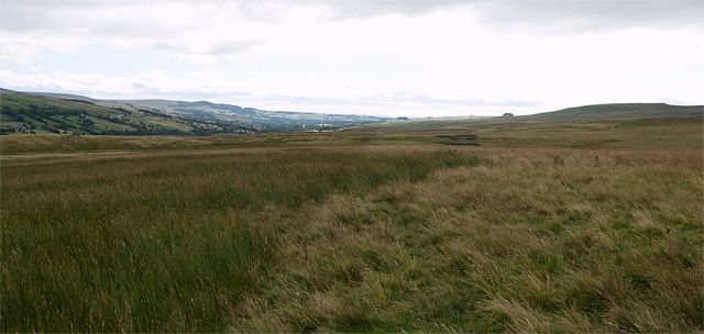
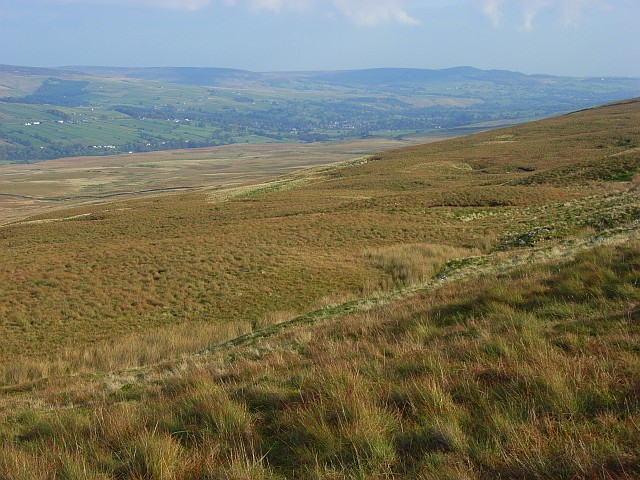
The landscape of Crooks o' Green Fell is characterized by its undulating hills, heather-covered moorlands, and scattered patches of woodland. The area is renowned for its breathtaking views, with vistas stretching as far as the eye can see. Nature lovers can revel in the abundance of wildlife that call this place home, including deer, grouse, and various bird species.

For those looking to explore the region, Crooks o' Green Fell offers an extensive network of walking trails and footpaths that wind through its diverse terrain. These trails provide an opportunity to immerse oneself in the beauty of the countryside, with each step revealing a new panorama or hidden gem.

Crooks o' Green Fell is also steeped in history, with ancient stone formations and ruins scattered across the landscape. Visitors can discover prehistoric burial mounds and remnants of old settlements, providing a glimpse into the area's rich heritage.

In addition to its natural and historical attractions, Crooks o' Green Fell boasts a warm and welcoming community. The nearby villages offer charming accommodations, traditional pubs, and local shops, where visitors can experience the authentic Yorkshire hospitality.

Overall, Crooks o' Green Fell is a captivating destination that showcases the beauty and charm of Yorkshire's countryside. Its stunning landscapes, diverse wildlife, and rich history make it an ideal retreat for both nature enthusiasts and those seeking a tranquil escape.

If you have any feedback on the listing, please let us know in the comments section below.

Crooks o' Green Fell Images

Images are sourced within 2km of 54.620183/-2.1545517 or Grid Reference NY9025. Thanks to Geograph Open Source API. All images are credited.

Wall and fence east of Green Fell A fence has run along the ridge line east-south-east from Green Fell to this point where a wall continues in the same direction. Unusually, from the same point there's a parallel fence close to the wall, some two or three metres from it. The fence was clearly put in place long after the wall and the wall is in good condition.  The fence has been erected for some reason; it's hard to fathom what.
Wall and fence east of Green Fell
A fence has run along the ridge line east-south-east from Green Fell to this point where a wall continues in the same direction. Unusually, from the same point there's a parallel fence close to the wall, some two or three metres from it. The fence was clearly put in place long after the wall and the wall is in good condition. The fence has been erected for some reason; it's hard to fathom what.
The wall on Crossthwaite Common
Tarn on Green Fell
Tarn on Green Fell
Upper Wemmergill Beck Sheepfolds by the beck
Upper Wemmergill Beck
Sheepfolds by the beck
Snow-filled gullies on Green Fell Very hard going in soft snow!
Snow-filled gullies on Green Fell
Very hard going in soft snow!
Slopes towards Green Fell Green Fell lies on the southern hill slopes of Teesdale and is part of the greater hill, Bink Moss. Upper Teesdale is seen in the distance.
Slopes towards Green Fell
Green Fell lies on the southern hill slopes of Teesdale and is part of the greater hill, Bink Moss. Upper Teesdale is seen in the distance.
Wall with 'hogg hole' above Wemmergill Beck The term 'hogg hole' is perhaps more properly a Lake District one than from Teesdale where the image was recorded. It refers to a hole through a dry stone wall at ground level which can allow sheep of a certain size to pass from one side to the other; holes can be closed with slabs of stone as in this case.
The distant slopes rise to Green Fell which is part of the greater hill, Bink Moss. Wemmergill Beck lies to the south (left in the photo) which drains the eastern side of Bink Moss.
(Note: Hogg is an abreviation for hogget which Wikipedia defines as... "a sheep of either sex having no more than two permanent incisors in wear". Nothing to do with pigs!)
Wall with 'hogg hole' above Wemmergill Beck
The term 'hogg hole' is perhaps more properly a Lake District one than from Teesdale where the image was recorded. It refers to a hole through a dry stone wall at ground level which can allow sheep of a certain size to pass from one side to the other; holes can be closed with slabs of stone as in this case. The distant slopes rise to Green Fell which is part of the greater hill, Bink Moss. Wemmergill Beck lies to the south (left in the photo) which drains the eastern side of Bink Moss. (Note: Hogg is an abreviation for hogget which Wikipedia defines as... "a sheep of either sex having no more than two permanent incisors in wear". Nothing to do with pigs!)
Valley of Wemmergill Beck Wemmergill Beck and its tributaries drain Lune Moor, a name given more prominence on OS maps at 1:50 000 than at larger scales. White tubes such as the one among rocks in the foreground are used by gamekeepers to mark positions where they lay trays of grit for grouse.
Valley of Wemmergill Beck
Wemmergill Beck and its tributaries drain Lune Moor, a name given more prominence on OS maps at 1:50 000 than at larger scales. White tubes such as the one among rocks in the foreground are used by gamekeepers to mark positions where they lay trays of grit for grouse.
View southeast from Hawk Rigg 2 photos stitched together.
Kirkcarrion can be seen on the horizon at right of centre.
View southeast from Hawk Rigg
2 photos stitched together. Kirkcarrion can be seen on the horizon at right of centre.
Wemmergill Beck An old sheepfold and mine building either side of the beck which can be seen cascading behind.
Wemmergill Beck
An old sheepfold and mine building either side of the beck which can be seen cascading behind.
Wemmergill Beck Looking downstream beside the two old sheepfolds.
Wemmergill Beck
Looking downstream beside the two old sheepfolds.
Lune Moor Looking across the valley of Wemmergill Beck to Scarset Rigg and How Top.
Lune Moor
Looking across the valley of Wemmergill Beck to Scarset Rigg and How Top.
Pool, Lune Moor In a shake hole and in an area where there are many large shake holes. They show the presence of limestone.
Pool, Lune Moor
In a shake hole and in an area where there are many large shake holes. They show the presence of limestone.
Lune Moor Looking across Green Fell with Teesdale beyond.
Lune Moor
Looking across Green Fell with Teesdale beyond.
The upper reaches of Wemmergill Beck Various streams gather together in this clough.
The upper reaches of Wemmergill Beck
Various streams gather together in this clough.
Lune Moor Vegetation is a mixture of heather, burnt and unburnt, and grass. An old sheepfold is just about visible in the middle distance.
Lune Moor
Vegetation is a mixture of heather, burnt and unburnt, and grass. An old sheepfold is just about visible in the middle distance.
Wall on Green Fell Looking towards Harter Fell with Teesdale on the left.
Wall on Green Fell
Looking towards Harter Fell with Teesdale on the left.
Lingy Hills An ironically grassy slope.
Lingy Hills
An ironically grassy slope.
Show me another place!

Crooks o' Green Fell is located at Grid Ref: NY9025 (Lat: 54.620183, Lng: -2.1545517)

Division: North Riding

Unitary Authority: County Durham

Police Authority: Durham

What 3 Words

///explained.lows.ages. Near Holwick, Co. Durham

Related Wikis

Holwick

Holwick is a small village in Teesdale, County Durham (district), England. Located in the Pennine hills, it consists of a few houses spread along a road...

Park End Wood

Park End Wood is a Site of Special Scientific Interest in the Teesdale district of west County Durham, England. The site occupies a low hill of Whin Sill...

Newbiggin, Teesdale

Newbiggin is a village and civil parish in County Durham, England. At the 2011 census the parish had a population of 146. It is situated on the north side...

Harter Fell, Lunedale

Harter Fell is an area of upland heath in west County Durham, England. It lies on the watershed between the River Tees to the north-east and the River...

Low Force

Low Force is an 18-foot (5.5m) high set of falls on the River Tees, England, UK. Further upstream is the High Force waterfall. Low Force is also the site...

Middle Crossthwaite

Middle Crossthwaite is a Site of Special Scientific Interest in the Teesdale district of County Durham, England. It is situated on the south bank of the...

Bowlees

Bowlees is a small village in County Durham, England. It is situated near Newbiggin, on the other side of Teesdale from Holwick. The visitor centre in...

Middle Side and Stonygill Meadows

Middle Side and Stonygill Meadows is a Site of Special Scientific Interest in the Teesdale district of County Durham, England. It consists of two separate...

Nearby Amenities

Located within 500m of 54.620183,-2.1545517
Stone Houses
Place: locality
Source: NPE
Lat/Long: 54.6230499/-2.1517121
Natural: shake_hole
Source: NLS-OS-NatGrid-110k-1940-60
Lat/Long: 54.6213885/-2.1582105
Natural: shake_hole
Source: NLS-OS-NatGrid-110k-1940-60
Lat/Long: 54.6208301/-2.1591117
Natural: shakehole
Source: NLS-OS-NatGrid-110k-1940-60
Lat/Long: 54.6181216/-2.1576097
Natural: shakehole
Source: NLS-OS-NatGrid-110k-1940-60
Lat/Long: 54.6163194/-2.1581247
Natural: shake_hole
Source: NLS-OS-NatGrid-110k-1940-60
Lat/Long: 54.6205692/-2.1580174
Natural: shake_hole
Source: NLS-OS-NatGrid-110k-1940-60
Lat/Long: 54.6194634/-2.1612575
Natural: shake_hole
Source: NLS-OS-NatGrid-110k-1940-60
Lat/Long: 54.6213146/-2.1598842
Natural: shake_hole
Source: NLS-OS-NatGrid-110k-1940-60
Lat/Long: 54.6202586/-2.1594336
Natural: shake_hole
Source: NLS-OS-NatGrid-110k-1940-60
Lat/Long: 54.6217618/-2.1613004
Natural: shake_hole
Source: NLS-OS-NatGrid-110k-1940-60
Lat/Long: 54.6209785/-2.158747
Natural: shake_hole
Source: NLS-OS-NatGrid-110k-1940-60
Lat/Long: 54.6212028/-2.1600559
Natural: shake_hole
Source: NLS-OS-NatGrid-110k-1940-60
Lat/Long: 54.6203704/-2.1583178
Natural: shake_hole
Source: NLS-OS-NatGrid-110k-1940-60
Lat/Long: 54.6211282/-2.1599271
Natural: shake_hole
Source: NLS-OS-NatGrid-110k-1940-60
Lat/Long: 54.6211158/-2.1597555
Natural: shake_hole
Source: NLS-OS-NatGrid-110k-1940-60
Lat/Long: 54.6218606/-2.1616223
Natural: shake_hole
Source: NLS-OS-NatGrid-110k-1940-60
Lat/Long: 54.6211903/-2.1587684
Natural: shake_hole
Source: NLS-OS-NatGrid-110k-1940-60
Lat/Long: 54.6206561/-2.1585324
Natural: shake_hole
Source: NLS-OS-NatGrid-110k-1940-60
Lat/Long: 54.6216127/-2.1600988
Natural: shake_hole
Source: NLS-OS-NatGrid-110k-1940-60
Lat/Long: 54.6203828/-2.1585324
Natural: shake_hole
Source: NLS-OS-NatGrid-110k-1940-60
Lat/Long: 54.621327/-2.1603134
Natural: shake_hole
Source: NLS-OS-NatGrid-110k-1940-60
Lat/Long: 54.6210288/-2.1592619
Natural: shake_hole
Source: NLS-OS-NatGrid-110k-1940-60
Lat/Long: 54.6217991/-2.1588972
Natural: shake_hole
Source: NLS-OS-NatGrid-110k-1940-60
Lat/Long: 54.6208673/-2.1582534
Natural: shake_hole
Source: NLS-OS-NatGrid-110k-1940-60
Lat/Long: 54.6211779/-2.1593049
The data included in this document is from www.openstreetmap.org. The data is made available under ODbL.

Have you been to Crooks o' Green Fell?

Leave your review of Crooks o' Green Fell below (or comments, questions and feedback).