Burtersett Low Pasture

Downs, Moorland in Yorkshire Richmondshire

England

Burtersett Low Pasture

Crag Side Road Crag Side Road leads from Countersett up on to the moors above Wensleydale. The Roman Cam High Road is just a short distance ahead.
Crag Side Road Credit: Marathon

Burtersett Low Pasture is a picturesque area located in the Yorkshire Dales, specifically in Yorkshire, England. It is situated amidst the stunning landscape of downs and moorland. The area is known for its natural beauty and is a popular destination for tourists and nature enthusiasts.

The low pasture itself is a vast expanse of rolling hills, covered in lush green grass and scattered with wildflowers. It offers breathtaking views of the surrounding moorland and distant hills, creating a serene and idyllic atmosphere. The landscape is dotted with dry stone walls and grazing sheep, adding to its charm.

The area is home to a diverse range of flora and fauna, with various species of plants and animals thriving in the fertile soil. Rare wildflowers, such as orchids and heather, can be found here, adding bursts of vibrant colors to the landscape.

Burtersett Low Pasture is also a haven for birdwatchers, as it attracts a wide variety of bird species. Visitors can spot birds such as curlews, lapwings, and skylarks soaring through the sky or nesting in the grassy areas.

Hiking and walking trails crisscross the low pasture, allowing visitors to explore its beauty up close. These trails offer opportunities to witness the stunning views, experience the tranquility of the surroundings, and discover hidden gems along the way.

Overall, Burtersett Low Pasture is a captivating location in Yorkshire, offering a blend of downs and moorland scenery. Its natural beauty, diverse wildlife, and peaceful ambiance make it a must-visit for those seeking an escape into nature.

If you have any feedback on the listing, please let us know in the comments section below.

Burtersett Low Pasture Images

Images are sourced within 2km of 54.300143/-2.1584039 or Grid Reference SD8989. Thanks to Geograph Open Source API. All images are credited.
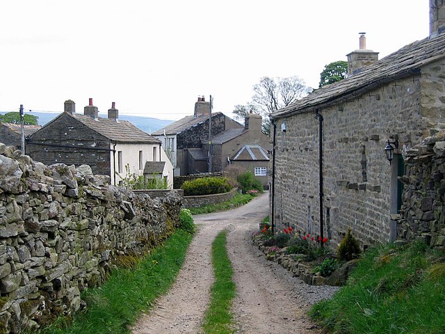
Crag Side Road Crag Side Road leads from Countersett up on to the moors above Wensleydale. The Roman Cam High Road is just a short distance ahead.
Crag Side Road
Crag Side Road leads from Countersett up on to the moors above Wensleydale. The Roman Cam High Road is just a short distance ahead.
Footpath from Crag Side Road Crag Side Road leads from Countersett up on to the moors above Wensleydale. The Roman Cam High Road is just a short distance to the left see also <a title="https://www.geograph.org.uk/photo/7327706" href="https://www.geograph.org.uk/photo/7327706">Link</a>
Footpath from Crag Side Road
Crag Side Road leads from Countersett up on to the moors above Wensleydale. The Roman Cam High Road is just a short distance to the left see also Link
Cam High Road Looking uphill.
Cam High Road
Looking uphill.
Cam High Road 2 Looking down towards Bainbridge.
Cam High Road 2
Looking down towards Bainbridge.
Crag Side Road Descending towards Countersett. Semerwater is hidden, but the view extends across Raydale to the fells beyond.
Crag Side Road
Descending towards Countersett. Semerwater is hidden, but the view extends across Raydale to the fells beyond.
Road at  Hawes End The road is from Countersett towards Burtersett and at this point appears to be heading straight towards the limestone capped bluff of Yorburgh, a twin of Addlebrough a few miles to the east.
Road at Hawes End
The road is from Countersett towards Burtersett and at this point appears to be heading straight towards the limestone capped bluff of Yorburgh, a twin of Addlebrough a few miles to the east.
Rural Wensleydale Wensleydale is generally wider and more lush than other valleys in the Yorkshire Dales. Here are flocks of sheep, but the accent here is more on cattle, particularly dairy herds which provide the raw material for the Hawes Creamery, home of authentic Wensleydale cheese.
Rural Wensleydale
Wensleydale is generally wider and more lush than other valleys in the Yorkshire Dales. Here are flocks of sheep, but the accent here is more on cattle, particularly dairy herds which provide the raw material for the Hawes Creamery, home of authentic Wensleydale cheese.
Small cairn beside bridleway above Raydale
Broken dry stone wall The wall is on Burtersett High Pasture, west of Yorburgh and close to a hill road descending to the village at Burtersett.
The two distant hills are Great Shunner Fell and Lovely Seat.
Broken dry stone wall
The wall is on Burtersett High Pasture, west of Yorburgh and close to a hill road descending to the village at Burtersett. The two distant hills are Great Shunner Fell and Lovely Seat.
Near New Bridge Looking NW, New Bridge is the only corner for miles on Cam High Road.
Near New Bridge
Looking NW, New Bridge is the only corner for miles on Cam High Road.
Green Scar Looking SE up at Green Scar.
Green Scar
Looking SE up at Green Scar.
High Lane into Burtersett On the right is the first house on this approach along High Lane. Mire Bank Lane, which is hidden from view joins High Lane a hundred metres or so ahead.
High Lane into Burtersett
On the right is the first house on this approach along High Lane. Mire Bank Lane, which is hidden from view joins High Lane a hundred metres or so ahead.
Burtersett village No need for a 30mph limit here as the narrowness of the village street makes half that speed seem risky. Burtersett was an old stone quarrying/mining settlement which a thousand years ago must have been the site of a Viking summer farm [sett/seter]. The current name was previously Beurtresate, meaning the seter by the elder trees [circa 1200]
Burtersett village
No need for a 30mph limit here as the narrowness of the village street makes half that speed seem risky. Burtersett was an old stone quarrying/mining settlement which a thousand years ago must have been the site of a Viking summer farm [sett/seter]. The current name was previously Beurtresate, meaning the seter by the elder trees [circa 1200]
Field gateway on south side of rural road east of Mile House Farm There is an Ordnance Survey benchmark <a href="https://www.geograph.org.uk/photo/1961039">SD8890 : Benchmark on gateway pier</a> on the left hand wall pier on the right hand side of the wooden post
Field gateway on south side of rural road east of Mile House Farm
There is an Ordnance Survey benchmark SD8890 : Benchmark on gateway pier on the left hand wall pier on the right hand side of the wooden post
Cows and barn in field on north side of road east of Long Shaw There is an Ordnance Survey benchmark <a href="https://www.geograph.org.uk/photo/1961068">SD8990 : Dry stone wall near Browna Paddocks</a>  on a stone in the roadside wall at the middle of the image
Cows and barn in field on north side of road east of Long Shaw
There is an Ordnance Survey benchmark SD8990 : Dry stone wall near Browna Paddocks on a stone in the roadside wall at the middle of the image
Stream in field west of Browna Paddocks
Buildings on south side of road at Browna Paddocks There is an Ordnance Survey benchmark <a href="https://www.geograph.org.uk/photo/1961117">SD8990 : Benchmark on outbuilding at Browna Paddocks</a>  at the junction of the large barn and the wall beyond it
Buildings on south side of road at Browna Paddocks
There is an Ordnance Survey benchmark SD8990 : Benchmark on outbuilding at Browna Paddocks at the junction of the large barn and the wall beyond it
Rural road heading east east of Browna Paddocks On the left hand verge (against the dry stone wall)  are an ancient milestone inscribed A(skrigg) 3 (miles) <a href="https://www.geograph.org.uk/photo/1960058">SD8990 : Milestone 17 miles to Sedbergh</a>  and a newer milepost <a href="https://www.geograph.org.uk/photo/6737380">SD8990 : Old milepost</a>.
Rural road heading east east of Browna Paddocks
On the left hand verge (against the dry stone wall) are an ancient milestone inscribed A(skrigg) 3 (miles) SD8990 : Milestone 17 miles to Sedbergh and a newer milepost SD8990 : Old milepost.
Show me another place!

Burtersett Low Pasture is located at Grid Ref: SD8989 (Lat: 54.300143, Lng: -2.1584039)

Division: North Riding

Administrative County: North Yorkshire

District: Richmondshire

Police Authority: North Yorkshire

What 3 Words

///field.elder.hospitals. Near Leyburn, North Yorkshire

Related Wikis

Burtersett

Burtersett is a small village in the Yorkshire Dales, North Yorkshire, England. It lies approximately 1 mile (1.6 km) east from Hawes and Gayle. The village...

Wensleydale

Wensleydale is a valley in North Yorkshire, England. It is one of the Yorkshire Dales, which are part of the Pennines. The dale is named after the village...

Sedbusk

Sedbusk is a hamlet near Hawes and Hardraw Force within the Yorkshire Dales in North Yorkshire, England. The hamlet is 1 mile (1.5 km) north of the town...

Dales Countryside Museum

The Dales Countryside Museum is a local museum for the Yorkshire Dales National Park in Northern England. Run by the National Park Authority, it tells...

Nearby Amenities

Located within 500m of 54.300143,-2.1584039
Natural: sinkhole
Source: OS_OpenData_Streetview
Lat/Long: 54.2980354/-2.1532828
Natural: spring
Source: OS_OpenData_Streetview
Lat/Long: 54.297923/-2.1531803
Barrier: stile
Material: stone
Source: survey;gps
Stile: squeezer
Lat/Long: 54.2996143/-2.1658529
Barrier: stile
Material: stone
Source: survey;gps
Stile: stepover
Lat/Long: 54.2996969/-2.1653984
Barrier: stile
Material: stone
Source: survey;gps
Stile: squeezer
Lat/Long: 54.3004588/-2.1646401
Barrier: stile
Material: stone
Source: survey;gps
Stile: squeezer
Lat/Long: 54.3006285/-2.1655782
Barrier: stile
Material: stone
Source: survey;gps
Stile: squeezer
Lat/Long: 54.3017018/-2.1651607
Barrier: stile
Material: stone
Source: survey;gps
Stile: squeezer
Lat/Long: 54.2981025/-2.1609295
Barrier: stile
Material: wood
Source: survey;gps
Stile: stepover
Lat/Long: 54.2990027/-2.1620499
Barrier: stile
Material: stone
Source: survey;gps
Stile: stepover
Lat/Long: 54.3001178/-2.1634136
Barrier: stile
Material: stone
Source: survey;gps
Stile: squeezer
Lat/Long: 54.3001992/-2.1634507
Barrier: entrance
Source: survey;gps
Lat/Long: 54.3007805/-2.1639089
Barrier: stile
Material: stone
Source: survey;gps
Stile: squeezer
Lat/Long: 54.3020548/-2.1644789
Access: yes
Barrier: cattle_grid
Lat/Long: 54.3028705/-2.1575037
Power: pole
Lat/Long: 54.3014805/-2.1651059
Power: pole
Lat/Long: 54.3015071/-2.1622279
Power: pole
Lat/Long: 54.3015399/-2.1606669
Power: pole
Lat/Long: 54.3015337/-2.1595055
Power: pole
Lat/Long: 54.3015665/-2.1579605
Power: pole
Lat/Long: 54.3015681/-2.1566087
Power: pole
Lat/Long: 54.3015822/-2.155222
Power: pole
Lat/Long: 54.3016088/-2.1538058
Power: pole
Lat/Long: 54.3016307/-2.1523547
Power: pole
Lat/Long: 54.3045777/-2.1579438
Power: pole
Lat/Long: 54.3034994/-2.1577352
Power: pole
Lat/Long: 54.3027208/-2.1575877
Power: pole
Lat/Long: 54.3019476/-2.1578331
Power: pole
Lat/Long: 54.3014886/-2.1642242
The data included in this document is from www.openstreetmap.org. The data is made available under ODbL.

Have you been to Burtersett Low Pasture?

Leave your review of Burtersett Low Pasture below (or comments, questions and feedback).